Our Mission
Our Office - Office Team
The United States Weather Bureau opened a weather office in the Aberdeen, South Dakota Airport Terminal building in June 1964. The office provided full-time services, including surface and upper air observations, to the Aberdeen Airport and surrounding communities. Budget reductions in 1978 led to staff and operations cuts. In July 1978, the Weather Service Office (WSO) Aberdeen staff of eight people was reduced to four and services were provided on a limited duty basis. WSO Aberdeen closed in September 1981 and the office was reopened a year later for 24-hour-a-day service during the week and limited duty on weekends. The station once again became a part-time, limited duty station in July 1986 with a staff of four people. WSO Aberdeen remained a limited duty station until the National Weather Service modernization of the 1990s. In February 1994, WSO Aberdeen resumed full-time, 24-hour operations in the Airport Terminal. The staff increased to 10 people to handle the increased responsibility.
In November 1994, the new modernized Weather Forecast Office building was completed on the east side of Aberdeen Regional Airport. WSO Aberdeen began operations in the new facility and as part of the agency’s nationwide modernization effort. In the fall of 1998, WSO Aberdeen became a full-fledged forecast office and was renamed Weather Forecast Office (WFO) Aberdeen South Dakota. This is the current-day structure. A fully-staffed office contains 23 employees: 14 operational meteorologists, two electronic technicians, a facilities technician, an information technology officer, an administrative support assistant, an electronic systems analyst, a science and operations officer, a warning coordination meteorologist, a data acquisition program manager, and a meteorologist-in-charge. The current-day County Warning and Forecast Area (CWA) covers 26 counties in two time zones (central and mountain) across central and northeastern South Dakota, and 2 counties in west-central Minnesota. We serve a population of about 185,000 people CWA-wide, including those in the capital of South Dakota, Pierre.
NWS Aberdeen and bordering NWS offices' county warning areas. National map here.

WFO Aberdeen produces weather warnings and advisories, daily forecasts, and digital or gridded forecasts for use by emergency managers, law enforcement, fire departments, land managers, aviation, media, and the public. The WFO staff also takes twice-daily upper air observations and collects surface and remotely-sensed weather data. All of these data streams are provided to the public via the WFO Aberdeen web page, and to the National Centers for Environmental Prediction for use in the national meteorological forecast models. We are also on Facebook (US National Weather Service Aberdeen South Dakota), Twitter (@NWSAberdeen) and Youtube.
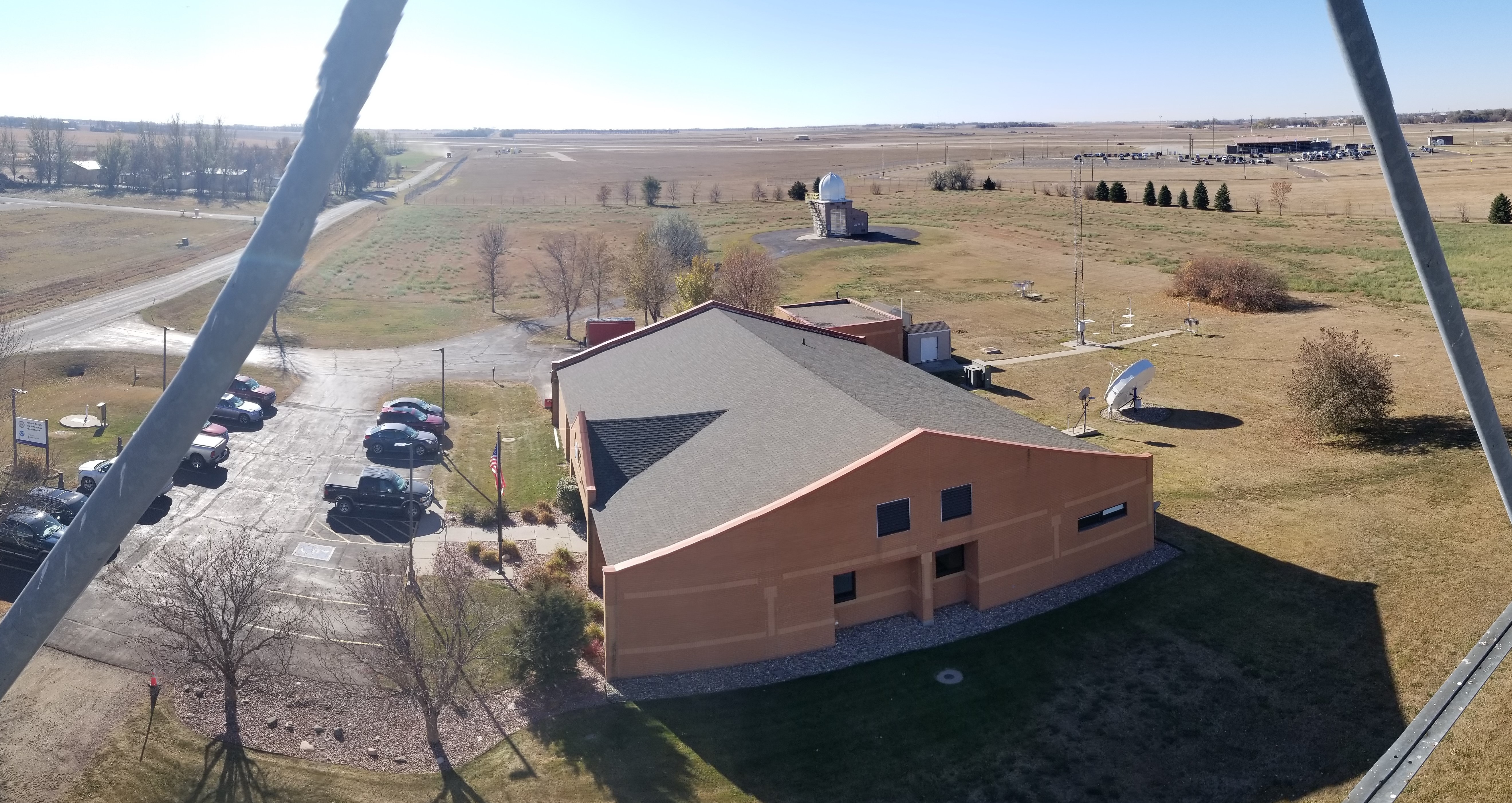
View of the NWS in Aberdeen, looking south from the radar tower in late October 2022.

Our Community
In its earliest years, Aberdeen was nicknamed the “Hub City” because it served as an important intersection for many busy railroad lines. The city’s name honors Aberdeen, Scotland, hometown of a railroad president who helped settle the community. Today’s “Hub City” has grown into a regional trade center that serves as an important crossroads for commerce, culture, government and healthcare. Situated in the fertile James River Valley, agriculture is one of Aberdeen's backbone industries, but new business and developments in healthcare, banking, construction and retail merchandising reveal the ongoing evolution. Some of the largest establishments in town are 3M, Aberdeen public schools, Avera St. Luke's Hospital, Walmart Supercenter, etc. (full top 10 list). Nonetheless, residents can still hear the sound of train whistles.
About 29,000 people call Aberdeen, South Dakota's 3rd largest city, their home. It's a small progressive city that hasn’t lost its warm, welcoming appeal and Midwestern hospitality. Tree-lined streets and comfortable, quiet neighborhoods characterize the community’s residential areas. Country residential options include hobby farms and homes/sites on the nearby Richmond and Mina Lakes. The cost of housing in Aberdeen is considerably lower than national averages, and homes in all price ranges are available. Additionally, the state of South Dakota doesn’t have a personal property tax or a state income tax. The Aberdeen regional airport offers twice daily Delta flights, and Lyft, Ride Line, and taxi companies operate in town. Interstate 29 traverses far eastern SD, and Interstate 90 southern SD.
Aberdeen has both fantastic public and private school systems. Northern State University offers degrees at the masters, baccalaureate, and associate levels in business, education, and most of the liberal arts programs. Presentation College, operated by the Catholic Presentation Sisters, is noted for high quality preparation in the health fields as well as business, education, social services, and computer science. Aberdeen is also the home of the South Dakota School for the Visually Handicapped.
Recreation-wise, there are a number of city parks and state rec areas, which provide opportunities for walking/jogging, biking, baseball and softball, swimming, volleyball, horseshoe, disc golf, basketball, tennis, fishing, water and cross-country skiing, sailing, camping. Golfing and bowling are also popular. Special attractions include the Dacotah Prairie Museum and Wylie Park, a 200-acre park which contains family entertainment with a small swimming lake, small zoo and among other things, Storybook Land which is an ode to various nursery rhymes and other stories including the Wizard of Oz (the author of which, L. Frank Baum, lived in Aberdeen during the late 1800s). Small and big game hunting is a prime pastime for many residents as well, with a large whitetail deer population (mule deer, elk and antelope west of the Missouri River), and world-renowned pheasant and waterfowl hunting.
Aberdeen city limits and NWS Aberdeen location
Our Weather and Climate
Four distinct seasons bring a wide range of weather across our area, from sweltering summer days to bitterly cold winter nights. The official Köppen-Geiger climate classifications across the County Warning Area are Dfa/Dfb (majority of area) and BSk (portions of central SD), which translates to "humid continental" and "mid-latitude steppe" respectively. Furthermore, due to our geographic position near the middle of the continent (north of Bismarck, ND) and far away from the moderating effects of the ocean, we observe some of the most variable weather in the country. For example, Aberdeen has recorded an air temperature range of 161° F (-46° F in 1912 and 1895, and 115° F in 1936), and an apparent temperature range of 178° F (-59° F wind chill in 1968, and 119° F heat index in 2011). Aberdeen's average annual apparent temperature range is 140-150° F. Furthermore, both the hottest and coldest temperatures on record in South Dakota were measured in our forecast area: 120° F in Fort Pierre and Gann Valley on July 15, 2006 and July 5th, 1936 respectively, and -58° F in McIntosh on February 17th, 1936. Aberdeen's average high temperature in July, its hottest month, is 84.9° F, and the average low temperature in January, its coldest month, is 1.9° F. Annually, Aberdeen receives a total of 21.82" of precipitation on average, June being the wettest with 3.76", and a total of 42.7" of snow, February being the snowiest with an average of 8.6". These are the climatologically norms, but as forecasters here can attest, "normal" here is seemingly just an average of the extremes.
Climate normals for precipitation and temperatures through the year at Aberdeen, SD.

A variety of airmasses across the High Plains and their interactions can result in a wide range of extreme and hazardous weather as well. During the cold season, powerful and deep low pressure systems can track east after developing off the front range of the Rocky Mountains, and impact our area with heavy snows in excess of two feet. Alberta Clippers, low pressure systems that come from the northwest, can bring bouts of snow and strong winds, resulting in blizzards. An infamous storm known as the Children's Blizzard resulted in the loss of over 200 lives across the region on January 12th, 1888, many of them children due to the storm's tragic timing. During the warm season, moisture streaming north from the Gulf of America in combination with evapotranspiration from mature corn crops helps to provide the instability needed for thunderstorm development. When other environmental ingredients are in place, heavy rains and flooding, severe winds, large hail and tornadoes occur. About 75% of homes in Aberdeen had at least some water in basements following 9.00" of rain from May 5th-6th in 2007. Aberdeen was also impacted at the start of a 32-mile long path F3 tornado on May 31st, 1996. On July 23rd, 2010, a hailstone measuring 8.0" in diameter, 18.625" in circumference, and 1.9375 pounds fell in Vivian, SD and became the largest hailstone in United States recorded history in terms of both diameter and weight. This area is susceptible to droughts as well, most notably during the Dust Bowl of the 1930's. Many other significant events, mostly recent in history, from our forecast area can be found here.
Topography can play an important role in our weather as well. With an elevation of 1,302 feet MSL, Aberdeen is positioned in the middle of the James River Valley, a virtually flat plain with uninterrupted views from horizon to horizon. Following a remarkably snowy end to the 2018-2019 cold season and wet 2019 spring, the James River began on April 3rd what became 546 consecutive days of flooding at the river gauge at Stratford, ending on September 30th, 2020 (national record). Conversely, the Coteau des Prairie, commonly referred to as the Prairie Coteau, extends roughly 800 feet above the surrounding plains and is the result of glacial activity. When southwesterly winds blow across this feature, they can accelerate down the eastern slope given certain atmospheric conditions. This can lead to localized blowing snow and even blizzard conditions during the wintertime. The extra elevation can also lead to a slight decrease in temperature that, in certain circumstances, makes the difference between a cold rain and an ice storm. Lake-effect snow can develop from Lake Oahe and other portions of the Missouri River as well.
Topography in and around NWS Aberdeen's County Warning Area.
