 |
| Photo by Leah Robertson |
|
|
|
|
The term monsoon generally refers to the seasonal reversal in atmospheric low-level circulations, particularly the surface winds and associated precipitation, resulting in a pattern of wet summers and dry winters. Monsoon circulations are present over many regions of the globe including Asia, Australia, North and South America and Africa. Many years ago, these monsoons were considered to be regional in scale. However, it is now known that monsoons are an important component of the large-scale global circulation. In terms of "weather", the monsoon is associated with a dramatic in increase in summer precipitation, mostly in the form of thunderstorms. The basic forcing of the monsoons is derived from a seasonal contrast in the heating of the land continent versus the ocean. New Mexico is impacted by the North American Monsoon System (NAMS), which is also referred to as the Southwest Monsoon. While precipitation increases in New Mexico associated with the monsoon are generally noted in July, development of the system takes place over Mexico during May and June. The animation below depicts the mean pressure pattern at 500 mb (middle tropospheric levels) for the months May through September. Note that in May, the pressure distribution is nearly zonal with westerly flow at most latitudes. By June, pressure increases over northern Mexico such that a high pressure cell (red shading), or a monsoon high, is readily apparent. This strengthening and northward movement of the high is one sign of the development of the North American Monsoon. By July and into August, the monsoon high migrates north with a mean position over New Mexico. |
|
|
|
|
|
Both upper level and surface circulations associated with the North American Monsoon transport moisture from the Pacific Ocean, the Gulf of California and the Gulf of America into Mexico and the Southwest U.S. As the upper level ridge shifts to the north, the prevailing winds change from westerly to south or southeasterly over much of Mexico and the southwest U.S. While this switch is dramatic across much of Mexico, it is also evident in vertical wind profile at Albuquerque. |
|
 |
A "typical" monsoon pattern is illustrated in the satellite image to the left. Thunderstorms are represented by areas of red, pink and blue. With upper level high pressure situated east of New Mexico, the clockwise flow around the high results in a south to north transport of moisture from Mexico into portions of New Mexico and Arizona. Thunderstorms that form under this regime will move from south to north or southwest to northeast. However, once monsoon moisture is in place, a number of synoptic patterns can support frequent rounds of thunderstorms. |
|
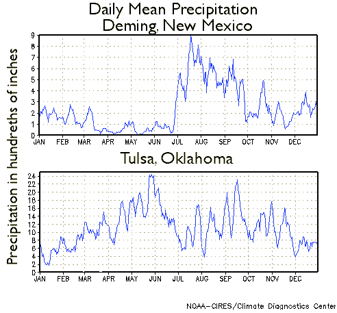
The evolution of the monsoon from Mexico to the United States is noted by the northward progression of convective precipitation from southern Mexico in early June that spreads northward into the southwest U.S. by early July. The onset of the NAMS in New Mexico varies, but average onset occurs around July 3 for the southwest corner of the state and around July 9 for the central Rio Grande valley, including Albuquerque. The daily mean precipitation plot for Deming, in southwest New Mexico (shown below), depicts the rather dramatic increase in precipitation in early July associated with the migration of the upper level high and monsoon onset. Similar mean precipitation data is also shown for Tulsa, OK, and illustrates a corresponding decrease in precipitation over the Great Plains in July. While portions of Mexico receive as much as 70% of their annual precipitation in July, August and September, the southwest corner of New Mexico receives about 50 to 60% of their annual precipitation for the same period with a decrease to 40 to 50% across the central and northern portions of the state. |
|
|
|
|
| |
|
|
Although a large scale circulation change supports the monsoon with an increase of atmospheric moisture, once onset occurs there is considerable variability in the day to day precipitation. Active periods of precipitation are known as monsoon "bursts", and are separated by drier, less active monsoon "breaks". The bursts are supported by a variety of patterns of low level moisture surges while the breaks often occur with an increase in westerly winds. An example is shown below, with 2008 summer precipitation for Deming clearly illustrating active or wet "burst" periods followed by dry "break" episodes. |
|
|
|
|
|
|
|
|
Interannual variability of the North American Monsoon System is controlled by both ocean and land conditions, including sea surface temperature, soil moisture and snow cover. |
|
|
As illustrated in the graph below, New Mexico precipitation for the 2-month period of July through August shows substantial variability from year to year. While the average from 1950 through 2010 is 4.83 inches, nearly double that amount was received in 2006 and the state averaged only 2.30 inches in 2003. The variability noted in New Mexico is common for all areas affected by the North American Monsoon System and has long been a topic of research. |
|
 |
|
|
Several studies have shown an inverse relationship with winter precipitation and monsoon precipitation for the following season. The figure below depicts the distribution of a precipitation index for Arizona and New Mexico for seasons starting with a wet winter (dashed line) versus a dry winter (dotted line) with a comparison to the mean value for all years (solid line). This study, published in 1998 was one of the first to document the inverse relationship such that wet winters are often followed by a drier than normal monsoon while dry winters are associated with a wetter than normal monsoon. |
|
|
|
|
|
Statistics using local New Mexico snowpack data for more recent years supports this relationship. The map below shows the average percent of the long-term average precipitation by climate division for monsoons following dry winters. Winters with snow pack less than 50% are generally followed by summers with above average precipitation. In fact, our recent record wettest monsoon (summer of 2006) followed an exceptionally dry winter. |
|
|
|
|
|
|
|
|
Field experiments, often supported by an enhanced platform of observations, can provide an opportunity for researchers to investigate ocean-atmospheric phenomenon. The North American Monsoon Experiment, or NAME, was an international effort designed to better understand the key physical processes associated with monsoon. A major component of NAME was a field campaign during the summer of 2004. This effort supplied a basis for recent research supporting the monitoring, diagnostics and modeling of the North American Monsoon. You can track the monsoon at the WFO Tucson site. More details regarding the science of the North American Monsoon System, including research on the variability of the monsoon, are also available. |
|


