 |
| Near Wallatowa, Photo by J. Brent Wachter |
 |
|
|
The two to three week period leading up to the moist onset of the Monsoon is one of the most critical periods for Southwest wildland managers in a calendar year. It is during this period that fuel conditions (grasses, tree canopy, shrubs, etc.) are usually the driest. It is also during this period that atmospheric moisture increases resulting in scattered thunderstorm activity.
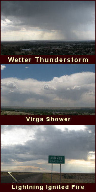
Some of the thunderstorms can be considered wet (upper right), in the sense that it rains hard or long enough to moisten the fuel bed, but often times the thunderstorms during this period produce lighter amounts of precipitation or just virga (middle right).
Due to the susceptibility of the fuel bed and to a lesser extent the drier nature of the thunderstorms, lightning ignited fires usually result (bottom right). Gusty and variable winds also accompany these thunderstorms and can help promote rapid and unpredictable fire spread for short durations. This leads to dangerous situations not only to wildland managers and firefighters but also to the public. About half of all wildfires reported in the Southwest region in the past 10 years have been lightning caused. |
|
|
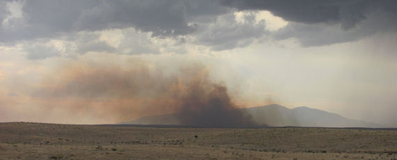
Jim Tucker, Chaves County Skywarn Coordinator, captured this image of a large grass fire that was started by lightning from a severe storm west-northwest of Roswell in early June 2011. Extremely dry conditions this year will contribute to the threat of wild fires due to lightning. |
|
|
|
|
 |
|
| Keeping a situational awareness is an important safety aspect.
There are various products that can alert you to the potential of lightning fire outbreaks, and these are listed below. Keep in mind though that it can only take one thunderstorm and one cloud to ground lightning strike to produce a catastrophic fire. There are various safety messages to adhere to during this critical fire period: |
|
 |
|
|
|
|
 |
|
|
In the fire agency world, large lightning based fire outbreaks are also known as “lightning busts”. These lightning busts can lead to multiple fire ignitions that can overwhelm local firefighting resources. Sometimes fires ignited from one of these thunderstorm patterns can lay undetected and smolder for several days. Often times this occurs in thick canopy forest such as found across the northern mountains. These fires are known as “sleepers” and can flare up under specific atmospheric conditions such as periods of low humidity, breezes, warm temperatures and an unstable atmosphere. More information can be found in two new fire weather features below: Dry Thunderstorms
|
|