| 2016 Weather Highlights | Hydrology/Drought Status | Fire Weather | Records and Extremes | Monthly Highlights | Severe Weather |
|
Review of Severe Weather Across New Mexico in 2016
|
|
Severe weather typically occurs across central and eastern New Mexico, however, there are occasionally reports west of the mountains, and many times those are flash flood reports. The map below shows the spatial variation of severe weather reports for 2016. Click on an individual balloon for more details on the event. |
|||||||||||||||||||||||||
|
|
|||||||||||||||||||||||||
|
Severe weather is defined as hail greater than or equal to 1 inch, thunderstorm wind gusts greater than or equal to 58 mph, a flash flood or a tornado. However, prior to January 5, 2010, the criteria for severe hail was 3/4 inch. For consistency, the table below, as well as the map above, includes all severe weather reports, including hail reports as small as 3/4 inch. This year, the National Weather Service in Albuquerque received 150 severe weather reports. The total number of severe weather reports across the state as a whole was 222. These totals do not include wind gusts greater than or equal to 58 mph that occurred from non-thunderstorm wind events. The table below shows the breakdown of reports received.
It should be noted, however, that winds less than 58 mph can blow over high profile vehicles, toss trampolines and cause tree damage to unhealthy trees.
|
|||||||||||||||||||||||||
|
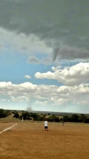
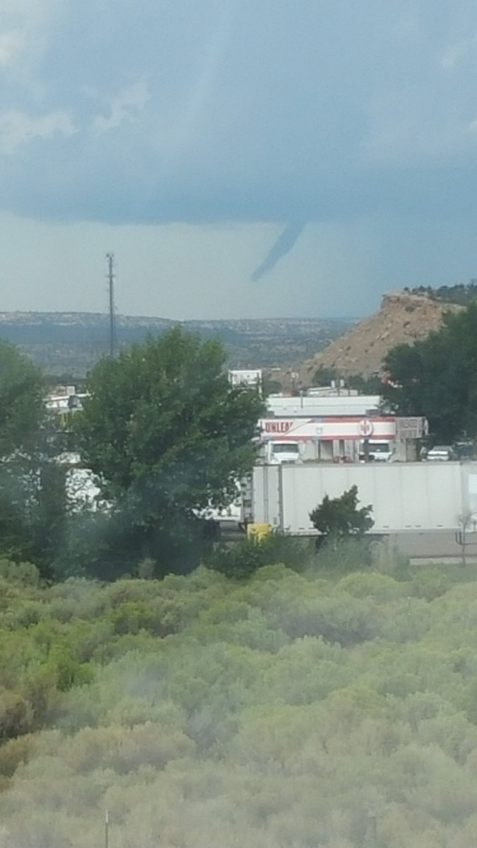
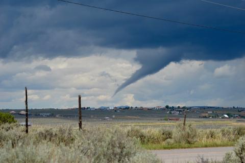
There were far fewer severe weather reports this year than in 2015. In 2015, there was a total of 398 reports across the state, nearly double this years total. Here are the top severe weather events that occurred in chronological order. January 26th: Though winter storms aren't typically thought of as a traditional severe weather event, they certainly can be "severe" in their own right. On the night of January 25th into the early morning hours of the 26th, intense snowfall rates of 2 to 3 inches per hour dumped between 24 and 30 inches of snowfall in the area between Chacon, Mora, Gascon and Ledoux, with higher amounts suspected at elevations above these areas. Outside of this area that spans no more than 20 miles, generally less than 10 inches of snow was reported. This extremely localized heavy snow event along the east slopes of the Sangre de Cristo Mountains left the citizens in these areas digging out for quite some time. Approximately 24 inches of snow near Mora on January 26th. Photos courtesy of Frieda Bustos. Various Dates May through August: There were many funnel cloud and landspout tornado reports this year, but fortunately, damage did not occur from any of them. Tornadoes and funnel clouds most often develop across eastern New Mexico from supercell thunderstorms, but they can and do occasional form west of the Central Mountain Chain. On May 18th, a spotter caught a picture of a well-developed funnel cloud near Datil, once again dispelling the myth that funnel clouds and tornadoes can't occur near mountainous terrain. Later in the year, on August 13th two landspout tornadoes developed on opposite sides of the state. One formed on a mesa near Capulin Volcano National Monument, while another formed near Ojo Encino which caught the attention of many people at a baseball field. Other well-developed funnel clouds were reported on July 2nd near Taos and August 28th near Gallup. Once again, both of these funnel clouds were west of the Central Mountain Chain!
Left: Funnel cloud southeast of Datil on May 18th. Photo courtesy of Jessica Murphey. Right: Landspout tornado near Capulin Volcano National Monument on August 13th. Photo courtesy of Jeffrey Bezore.    Left: Landspout Tornado near Ojo Encino on August 13th. Photo courtesy of Glenyall Herschel. Center: Funnel Cloud near Gallup on August 28th, courtesy of Sam Fry. Right: Funnel Cloud near Taos on July 2nd courtesy of Elizabeth Mason.
August 5th: A devastating flash flood event occurred the night of August 5th near Shiprock. Heavy rain fell upstream of Shiprock on Salt Creek Wash. Hours later, a wall of water surged downstream and caused major damage to a community near Mesa Farm Road. Three to four homes were severely damaged and one home was destroyed. Several vehicles, motorcycles, and recreational vehicles were washed into the creek and destroyed. Folks in this area were rescued from their rooftop. Remarkably, no one was killed.
After a raging torrent of water raced through Salt Wash, these photos show the damage it left in its wake. Photos courtesy of Steve Lewis, Farmington Daily Times. August 22nd: An otherwise benign day of isolated to scattered showers and thunderstorms across New Mexico was disrupted by life threatening flash flooding over far southeastern Rio Arriba County. Thunderstorms repeatedly developed and shifted eastward over Hernandez, Chamita, and Alcalde. Hail and torrential rainfall were reported for several hours. Emergency management estimated up to 30 homes were inundated with water and mud. Many vehicles were overturned in flood waters and at least three water rescues took place. The most significant damage occurred along Highway 74 where a mobile home was washed off its foundation over 50 feet downstream. Numerous roads were impassable. Local DOT officials said for the first time the main arroyo that crosses under U.S. Highway 285 at Hernandez topped the roadway by up to 4 inches. Locals in the area said this was the worst flood they have observed in several decades.
Top: Flooding aftermath near Hernandez, a small community off Highway 285 10 miles north of Espanola. Bottom: Pea to dime size hail piled up along the side of an arroyo in Hernandez approximately 3 to 4 feet high. The brown area, debris from the flood, was mainly on the surface. Those surveying the damage did not have to dig far to reach the hail accumulation. Photos by Kerry Jones. August 29th: Impressive flash flooding occurred over the Dog Head burn scar in the Manzano Mountains during the afternoon of August 29th. An upper level low pressure system nearly stationary over the Four Corners and an upper high level pressure system over the lower Mississippi River Valley generated a deep tap of very rich moisture across central and eastern New Mexico. A line of slow-moving thunderstorms dumped 1 to 3 inches of rainfall along the Highway 337 corridor from near Tajique north to the Chilili area. Many folks captured footage of arroyos out of their banks, culverts at maximum capacity, and large areas of standing water. At peak, approximately 3 to 4 feet of water was flowing over Highway 337 near Tajique. Fortunately no injuries or significant damage occurred.
Dog Head burn scar flash flooding. Photos courtesy of Ashley Krystal (left) and Bill Simms (right). September 15th: Arguably one of the most active severe weather days of the year, September 15th started with a tornado developing just after midnight near Melrose. A nearby resident reported a loud, distant roaring sound over the Melrose Bombing Range when radar indicated very intense rotation. A storm survey of this extremely remote location later revealed a 2000 pound mobile office trailer that was bolted and strapped down was lifted and moved eight to ten inches. Later that afternoon, another round of severe weather developed. Several supercell thunderstorms developed by early afternoon and moved east across the plains. A funnel cloud was reported just after the noon hour near Vaughn, but the most active and persistent area of thunderstorms was across eastern Lincoln and southwest Chaves counties. Supercells with near continuous rotation churned over this area for much of the afternoon. Though much of this area is rural, we did receive reports of nickel to quarter size hail in the area around Tinnie, Picacho, and Dunken. Also, a tornado and golf ball size hail were then spotted over rural ranch lands to the northeast of Dunken.
Top: Radar reflectivity at 1205am on September 15th near the time of the Melrose tornado. Bottom left: Funnel Cloud 5 miles south of Vaughn around 1205pm. Photo by Razi Nasrullah. Bottom Right: Tornado on U.S. 82 near Picacho Road at 215pm. Photos by Christopher Holman. November 5th: For the first time in recorded history, severe hail was recorded in Bernalillo County in November. Penny to half dollar size hail fell across eastern portions of Albuquerque. A severe storm quickly developed and moved north during the evening hours.
Severe hail fell across much of eastern Albuquerque, including these stones in Uptown. Photo by Todd Kurtz, KOAT. |
|||||||||||||||||||||||||
|
Other notables: Seven of the eight tornadoes across New Mexico were rated EF-0, while one tornado in Hidalgo County was not rated since a survey team could not get out to the area to assess the damage, though it is suspected that there was not any. The largest reported hail size this year was in Eddy County near Seven Rivers where a 4 inch hailstone fell on September 15th. The hail dented a vehicle and broke its windshield. The strongest thunderstorm wind gust that was reported was estimated to be around 80 mph near Bingham on May 31st which was associated with a downburst. The highest non-thunderstorm wind gust was a whopping 110 mph at San Augustine Pass in southern New Mexico on December 17th, though not far behind was a 105 mph wind gust at Taos Ski Valley's Kachina Peak on Christmas day. |
|||||||||||||||||||||||||
|
How does 2016 compare to normal? Since 1950, the average number of tornadoes reported in the state is 8 to 9, which makes 2016 right about average. At least one tornado has been reported each year since 1953, and before that it is likely that most tornadoes went unreported. The highest number of tornadoes ever reported was in 1991, when 31 tornadoes devastated parts of the state, especially Eddy and Lea counties. The average number of hail reports has steadily increased since 1950 due to increased awareness, and today the average number of events is near 130. Thus makes the number of severe hail reports this year right about normal as well. Complete flash flooding records only date back to 1993, however since then, the average number of flash flooding events is around 40 per year. In 2016, there were about 1.5 times the normal number of flash flood events. Reported thunderstorm wind events were below the average number of 35 events per year.
|
|||||||||||||||||||||||||
|
The graph on the left shows the distribution of New Mexico severe weather events by month. New Mexico's primary severe weather season is in the spring, though a secondary season often occurs in the fall. This is primarily illustrated by the hail events this year. This graph also shows that flash flooding in New Mexico is most frequent during monsoon season. Click on the graph for a larger image. |
|||||||||||||||||||||||||
| (Return to the main page) | |||||||||||||||||||||||||