WSR-88D MESOCYCLONE CHARACTERISTICS OF SELECTED THUNDERSTORMS DURING THE SOUTHWEST GEORGIA TORNADO OUTBREAK ON 13-14 FEBRUARY 2000
T. J. Turnage*
NOAA / National Weather Service, Tallahassee FL
Robert R. Lee
NOAA / Operational Support Facility, Norman, Oklahoma
E. Dewayne Mitchell
NOAA / National Severe Storms Laboratory, Norman, Oklahoma
1. INTRODUCTION
On 13-14 February 2000, at least four strong tornadoes swept across portions of southwest Georgia. The hardest hit community was Camilla, which was struck by a tornado estimated to be of F3 intensity on the Fujita scale (see Fig. 1 in Gould et al. 2000 in this Preprint volume). This tornado produced 10 fatalities. Approximately 45 minutes later, another supercell thunderstorm produced a tornado with an identical track to the first, and resulted in an additional fatality in Camilla. Yet another supercell later produced two tornadoes 40 minutes apart in Grady County and along the Colquitt/Tift County line near Omega (Fig. 1 in Gould et al. 2000). Detailed aerial surveys allowed the tornado tracks to be resolved accurately. These mesocyclones occurred at ranges from the Tallahassee WSR-88D Doppler radar (KTLH WSR-88D) that varied from 70 km for the Grady County tornado to 127 km for the Omega tornado.
This paper will investigate trends of depth, rotational velocity, and shear of these tornadic mesocyclones as depicted by the KTLH WSR-88D. Selected output parameters from the NSSL Mesocyclone Detection Algorithm (MDA; Stumpf et al. 1998) will then be assessed to determine which parameters, if any, could be effective predictors of tornadoes for these events. Finally, the WSR-88D Build 10 Tornado Detection Algorithm (TDA; Mitchell et al. 1998) will be scored using procedures developed by the Operational Support Facility (OSF) and the National Severe Storms Laboratory (NSSL), and an adaptable parameter set optimized for this severe weather episode will be developed and discussed.
2. METHODOLOGY
KTLH WSR-88D Archive level II data were collected and analyzed using WATADS version 10.2 (NSSL 2000). The pertinent mesocyclones were identified in reflectivity and storm-relative velocity product animations. The mesocyclone tracks were correlated by location and by WSR-88D volume scan times with the specific damage tracks assessed from aerial surveys. Once tornado occurrence times were determined in this way, time-height trends of mesocyclone rotational velocity, gate-to-gate velocity, shear, and diameter were plotted using the WATADS trend feature. Finally, the TDA was scored using procedures highlighted in the WSR-88D Algorithm Scoring Procedures (OSF 1999).
3. RESULTS
The first mesocyclone analyzed was associated with the first Camilla tornado. The WSR-88D depicted a steady increase in mesocyclone depth prior to the tornado, with a steady decrease in depth during the tornado's lifetime (not shown). Around 0421 (all times UTC), about 20 minutes before the Camilla tornado, there was a maximum of rotational velocities > 35 m/s that appeared simultaneously in the lowest elevation slices (Fig. 1). Damage surveys were not taken of the area the mesocyclone passed over at this time, so it is possible that these higher rotational velocities were associated with an unreported tornado.
Figure 1 also shows that slightly higher rotational velocities appeared to descend from the 1.5 degree elevation slice at 0436 just prior to touchdown of the Camilla tornado. However, improperly dealiased velocities were depicted by the WSR-88D at this slice and time (not shown), so it is theorized that the descent was falsely implied by this dealiasing problem.
This theory is corroborated in Figure 2, which indicates an abrupt and simultaneous increase of gate-to-gate velocities in the lowest two elevation slices. Shear trends (Fig. 3) show values peaking in the lowest elevation slice at the onset of the Camilla tornado, although in the earlier strong circulation occurring around 0421, a descent of higher shear values is evident.
Next, the second tornadic Camilla mesocyclone was investigated. Aerial and ground surveys were unable to resolve an individual damage track with this tornado because it overlapped the track of the first. Starting and ending times for this second Camilla tornado therefore remain uncertain; however, rotational and gate-to-gate velocity trends (Figs. 4 and 5) strongly suggest a tornado was on the ground by 0525, about 15 minutes prior to the final fatality in Camilla.
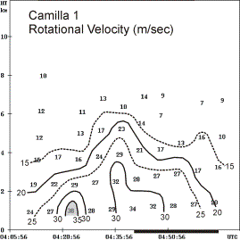
Figure 1. Time series plot of WSR-88D detected rotational velocity in m / s.
Mesocyclone depth rapidly fluctuated prior to and during the probable time of this tornado (not shown), and Figures 4 and 5 show that the detected mesocyclone base dropped dramatically around 0510. These figures also show stronger and deeper rotation compared to the first Camilla tornado. With a track virtually identical to the first tornado, the second Camilla tornado should have been sampled by the WSR-88D equally well. As in the case of the first tornado, rotational and gate-to-gate velocities increased simultaneously in the lowest elevation slices, most notably in the lowest 4 slices of Figure 5. Unlike the first Camilla tornado, the highest shear and lowest diameter values remained aloft in the second and third elevation slices while lowest diameters were correspondingly greater (Figs. 6 and 7).

Figure 2. Same as Figure 1, but for gate-to-gate velocity.

Figure 3. Same as Figure 2, but for shear.
Next, the mesocyclone that produced a tornado in northern Grady County was analyzed. Figure 8 shows higher rotational velocities at the 1.5 degree elevation slice lasting for three volume scans prior to tornado touchdown. High gate-to-gate velocities of at least 50 m/s similarly spread down from the 1.5 degree slice (not shown). Figures 9 and 10 show a descent of high shear and small diameter immediately before the tornado. In fact, the mesocyclone diameter at the 0.5 degree elevation slice shrank from 8 km to 3 km just prior to the tornado. This descent of tightening circulation was pronounced enough to cause a corresponding (increase, decrease) in MDA derived (depth, base height) just prior to the tornado (Fig. 11).

Figure 4. Same as Fig. 1, but for the second Camilla tornado. The estimated time of the additional damage and fatality in Camilla is labeled with a bar.

Figure 5. Same as Fig. 4, but for gate-to-gate velocity.
The supercell that produced the Grady County tornado produced another tornado near Omega from 0642 to 0648. The last 0.5 degree slice of the associated mesocyclone was detected by the WSR-88D MDA at 0633. At 0645, the MDA assigned a new mesocyclone identifier to the circulation responsible for the Grady County tornado, despite the fact velocity data showed a persistent rotational couplet this whole time. The MDA’s problem with mesocyclone continuity greFFCy hindered the effectiveness of the trend feature for this tornado. This effect was noted with other mesocyclones for this event when increasing range or multiple mesocyclone detections played a role.
Finally, a Tornado Detection Algorithm (TDA) adaptable parameter set (APS) was optimized for this tornadic outbreak. Each APS consists of a combination of thresholds for the Tornado Vortex Signature (TVS) depth, Low-Level Delta-Velocity (LLDV), and Maximum Delta-Velocity (MXDV) detected within the TVS.
Table 1 compares the four operationally approved APSs with the one optimized for this event. The high event thresholds (bottom row) emphasize the large and strong nature of the circulations that occurred. In fact, thresholds for this outbreak even exceed those for the Isolated Supercell set (labeled Super in Table 1).
The Default and Squall Line/Tropical APSs (Def and Squall, respectively, in Table 1) both had an identically high Probability of Detection (POD) for this event, but because thresholds were too low, each False Alarm Rate (FAR) was higher, resulting in a lower Critical Skill Index (CSI) and Heidke Skill Score (HSS) compared to the optimized APS. It is interesting to note how similarly these two APSs performed. Even for this strong event, the Minimized set (Min in Table 1) had thresholds set too high, as evidenced by a very low POD, CSI, and HSS.

Figure 6. Same as Fig. 4, but for shear.
4. CONCLUSIONS
WSR-88D algorithm-derived trends of depth, shear, and rotational velocity were investigated for three mesocyclones. The best predictor for tornado occurrence was rotational velocity exceeding 35 m s-1 in the lowest elevation slice. This predictor was corroborated by the TDA APS optimized for this event. For both Camilla tornadoes, rotational velocities increased abruptly and simultaneously in the lowest elevation slices, which would have resulted in late warnings had this predictor been used alone.

Figure 7. Same as Fig. 4, but for diameter.
The rapid development of the Camilla tornadoes in the lowest elevation slices suggests a boundary layer mechanism strongly contributed to tornadogenesis. The Grady County tornado showed a more classic descent of higher rotational velocities and a well-defined increase of shear in the lowest elevation slice corresponding to a significant decrease in mesocyclone diameter. Surface mesoanalyses of southwest Georgia during the event revealed an outflow boundary the mesocyclones crossed prior to tornadogenesis (not shown; Fournier 2000). Such boundary interactions leading to tornadogenesis have been documented in other studies (e.g., Maddox 1980, Rasmussen 2000).

Figure 8. Same as Fig. 1, but for the Grady County tornado.
Mesocyclone depth trends varied prior to tornadogenesis for each case, so depth alone was not a good predictor of tornadoes; however a gradual decrease in depth was noted in all cases while the tornadoes occurred.
The APS optimized for this event suggests the tornadic circulations that occurred were qualitatively comparable to those found with isolated supercells of the Great Plains. Use of this optimized APS would likely result in a low POD for the types of tornadoes that normally occur in the Tallahassee County Warning Area. Future work will focus on developing an APS that represents a broader spectrum of local cases.
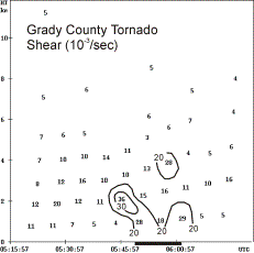
Figure 9. Same as Fig. 6, but for the Grady County tornado.
Overall, the WATADS trend feature for this outbreak was very useful, but mesocyclone continuity problems were noticed with mesocyclones poorly defined by increased range or multiple detections. Real-time use of this feature in the Warning Decision Support System (NSSL 2000) would likely help severe weather operations significantly.
Acknowledgments: A special thanks to Irv Watson (NWS Tallahassee SOO) for his assistance with the figures and helpful suggestions.
5. REFERENCES
Available on request.

Figure 10. Same as Fig. 7, but for the Grady County tornado.

Figure 11. Mesocyclone base height and depth for the Grady County tornado.
|
Parameters |
Scores |
||||||
|
APS |
Depth (km) |
LLDV (m/s) |
MXDV (m/s) |
POD |
FAR |
CSI |
HSS |
|
Min |
5.0 |
56 |
74 |
.13 |
.25 |
.13 |
.18 |
|
Def |
1.5 |
25 |
36 |
.91 |
.56 |
.42 |
.41 |
|
Squall |
1.6 |
27 |
27 |
.91 |
.58 |
.40 |
.39 |
|
Super |
3.1 |
27 |
30 |
.86 |
.54 |
.43 |
.43 |
|
Event |
3.2 |
39 |
43 |
.78 |
.31 |
.58 |
.65 |
Table 1. WSR-88D TDA Adaptable Parameter Set Comparison.
* Corresponding author address: T. J. Turnage, National Weather Service, 3300 Capital Cir. SW, Tallahassee, FL 32310; e-mail: Thomas.Turnage@noaa.gov


 Follow us on YouTube