UTILIZING RADAR DATA TO IMPROVE STREAMFLOW FORECASTS
Keith Stellman¹, Henry Fuelberg², Reggina Garza³ and Mary Mullusky³
¹National Weather Service/Florida State University, Tallahassee, Florida
²Florida State University, Tallahassee, Florida
³Southeast River Forecast Center, Peachtree City, Georgia
1. INTRODUCTION
In a typical year flooding kills more people in the United States than any other weather phenomena. Major efforts have been underway for several years to improve flood forecasts. For example, technology has advanced the skill of river forecasting by allowing streamflow models to be run on local computers at river forecast centers. Shortage of observations from sparse rain gage networks has been a limitation; however, today’s forecasters have more available data, including observations at both a greater spatial and temporal resolution. Forecasters now are beginning to test fine scale radar derived rainfall data which could prove to be a great advantage in river forecasting.
The National Weather Service River Forecast System (NWSRFS) is a comprehensive set of models and hydrologic techniques used by the National Weather Service River Forecast Centers to forecast streamflow during both flooding and non-flooding conditions. This paper examines the simulated and observed streamflow at Culloden GA., a forecast point within the Southeast River Forecast Center (SERFC) area of responsibility. Precipitation and streamflow data from various types of observing stations are needed as input to the NWSRFS. This data is obtained for the Culloden basin from gages operated by agencies such as the United States Geological Survey (USGS) and the National Weather Service (NWS). This paper will compare simulated streamflow within the calibration mode of NWSRFS.
The current procedure for simulating streamflow utilizes rainfall expressed as a single 6-hour Mean Areal Precipitation (MAP) value over the river basin. MAP is calculated from rain gage data, and the resulting MAP value is used for the entire basin regardless of its size, shape, and topography. It has been shown that utilizing 1-hour radar-derived rainfall data over small watersheds (< 200 mi2) increases the lead time for forecasting in flash flood events (Davis and Jendrowski, 1993). The use of fine scale rainfall data from the WSR-88D Doppler Radar to improve streamflow forecasts has also been investigated by Mike Smith, at the NWS Office of Hydrology (OH) (Smith et al., 1996a).
This paper investigates the potential for obtaining improvements in river streamflow simulations by taking advantage of finer scale radar-derived precipitation data with smaller river basins.
2. OBJECTIVES
The current study examines the potential improvements in streamflow simulation by using finer scale rainfall input, i.e. radar derived MAP with semi-distributed hydrologic models. The study consists of two components. The first is a statistical analysis of radar-derived mean areal precipitation (MAPX) and rain gage based mean areal precipitation (MAP). The second component uses NWSRFS with MAP forcing to compare simulated streamflow for a total basin with simulated streamflow for the basin divided into sub-basins. This process is repeated using MAPX. Finally, the streamflow simulations are compared to the observed streamflow. This research is an extension of that proposed by Smith et al., 1998. Our hypothesis is that by dividing a lumped basin into semi-distributed basins, and using either MAP or MAPX, a more accurate streamflow forecast should be produced.
3. METHODOLOGY
The river basin selected for this study corresponds to the headwater of the Flint River, GA, specifically the Flint River at Culloden (Fig. 1). The basin was chosen because of the heterogeneity, it includes large urban regions in the northern portion as well as sparsely populated agricultural areas in the southern region. The Culloden basin has been divided into six sub-basins according to topography and data availability from the USGS.
A composite of radar-derived rainfall estimates and rain gage data on a 4 x 4 km grid at an hourly time step has been used to generate a time series of basin and sub-basin MAPX at 6-hour intervals.
Since the NWSRFS will be used to simulate streamflow for the basin and sub-basins, the different operations comprising the system must be defined. The rainfall/runoff model and unit hydrograph define basic hydrologic operations for any basin or sub-basin. To move a sub-basin outlet hydrograph to a point downstream, routing is employed.
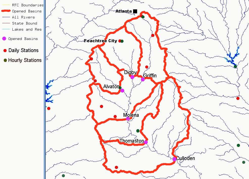
Figure 1. Sub-basins and rain gages for the Flint River at Culloden.
Rainfall/runoff models are used to compute the amount of rainfall that reaches the stream. Most River Forecast Centers (RFCs) currently use the Sacramento Soil Moisture Accounting model (SACSMA) to compute runoff for a lumped basin (McIntire et al., 1998). Numerous parameters within SACSMA must be specified for a given basin before a streamflow forecast can be produced. These parameters represent characteristics such as percentage of impervious areas, vegetation cover, and percolation rates, which must be defined for each basin.
This study utilizes the SACSMA rainfall/runoff model by calibrating the SACSMA parameters for the lumped basin and maintaining those same parameters for the sub-divided basins, where historical data is not available for calibration.
Unit hydrographs are used to convert runoff, generated with the rainfall/runoff model, to a direct runoff hydrograph. Unit hydrographs can be developed using streamflow data, synthetic methods, or conceptual analysis. Synthetic unit hydrographs usually are derived from characteristics of the basin when historical streamflow data does not exist. Synthetic unit hydrographs will be derived for the six sub-basins. A software package called the Integrated Hydrologic Automated Basin Boundary System (IHABBS) will be used to generate synthetic unit hydrographs for the sub-basins (NWS-OH et al., 1998). This tool utilizes high resolution topographic maps and offers several methods of generation. The Soil Conservation Service (SCS) method of generating synthetic hydrographs will be used for this study due to its physically based parameterization and the availability of soil and land use maps.
Routing methods will be defined for each of the sub-basins to move the sub-basin outlet hydrograph to Culloden. Many routing methods are available, but those most commonly used within NWSRFS are storage routing models, including the Muskingum model, Lag and K, and Layered coefficient routing (Fread, 1985). These models are based on conservation of mass and an approximate relation between flow and storage. Due to the lack of streamflow data in the sub-basins, routing parameters will be defined using the Muskingum-Cunge method. Muskingum-Cunge uses physical characteristics of the basin to determine the routing parameters that other methods determine from historical data (Viessman, 1996). Although NWSRFS does not support Muskingum-Cunge, the routing parameters may be used in the NWSRFS Muskingum operation.
Once the basin is defined in NWSRFS, the model will be run for 42 years (1955-1996) using 6-hour MAP to calibrate the SACSMA parameters. Beginning in June 1996, MAPX and MAP at 6-hour intervals will be used separately to simulate streamflow. Specifically, lumped and semi-distributed MAP and MAPX will be used to calculate separate estimates of simulated streamflow at the Culloden river gage. Simulated stream flows from both the entire basin, and that derived from the sub-basins, will be compared to observed data at the Culloden river gage. This comparison should identify whether a greater spatial resolution provided by the semi-distributed approach produces a more accurate streamflow simulation.
4. RESULTS
4.1 Statistical Analysis of MAPX and MAP
MAPX was compared to MAP for a summer season (June-August) when convective activity is predominant, and a winter season (November-February) when stratiform precipitation is expected, as well as for the entire period (June 96-July 98). This was done for the whole basin as well as for each sub-basin to see if basin size has a role in the differences. It was found that MAPX underestimated rainfall by about half during the winter months (Figure 2). However, the correlation between MAP and MAPX was the highest during these months. This implies that the radars are capturing the precipitation but are underestimating it. The opposite was found when comparing the two during the summer season. The MAPX means are slightly higher during this season, but the correlations are lower (Figure 3). This is especially true for the smaller sub-basins where there is no significant correlation between MAP and MAPX. These results should be expected in summer due to the sparcity of the rain gage network and the spatial variability of convective events.
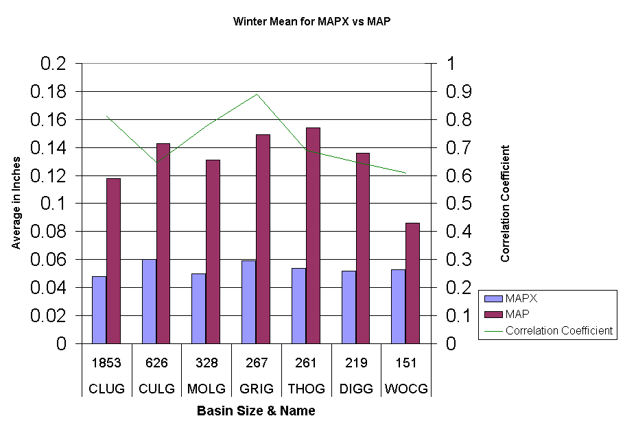
Figure 2: Mean MAPX and MAP for the winter season by basin and sub-basins.
MAPX and MAP were summed up over the entire period (June 96-July 98) to see any differences in total rainfall. These sums were compared to sums for a daily (Talbotton) and an hourly (ATL-NWS) rain gage stations (Figure 4). MAPX underestimated rainfall by about 40 inches for the two-year period as compared to the individual gages and MAP. Since the mean MAPX and MAP were similar during the summer, the deficit appears to come from the winter season.
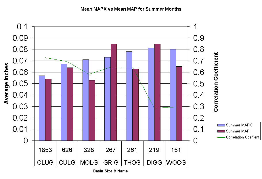
Figure 3: Mean MAPX and MAP for the summer season by basin and sub-basins.
An example of this was seen during the week of March 6, 1998 which is the largest event that occurred during the two year span. This was a widespread stratiform rainfall event caused by isentropic lift with only a few convective type storms occurring. MAP calculated just over 6 inches during the 3-day event whereas MAPX estimated only 2 inches of rainfall. These kinds of discrepancies would have large adverse effects on the model trying to simulate streamflow.
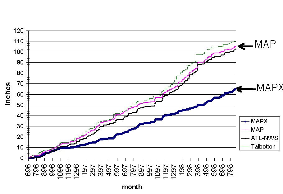
Figure 4: Cumulative sum of MAPX and MAP for Culloden, and a daily rain gage site (Talbotton), and one hourly rainfall rain gage site ( ATL-NWS) .4.2 Streamflow Simulation
Streamflow simulations using MAPX and MAP for the whole basin have been completed. It has already been established that MAPX is underestimating rainfall when compared to the gages and MAP; therefore, one would expect an underestimation of the resulting streamflow. However, preliminary results for the lumped simulation using MAPX for the selected period (June 96-July 98), showed very little and sometimes no visible response. However, these values must be looked at with caution since the model results are based on SACSMA parameters determined by calibration of the lumped model using MAP, not MAPX.
5. CONCLUSIONS AND RECOMMENDATIONS
Preliminary results suggest that MAPX cannot be used without calibrating the model using MAPX. Although it has been shown that at least 8 years of data are needed to calibrate the model properly, the 2 years of MAPX data will be used to calibrate the SACSMA parameters. Otherwise, the use of MAPX for streamflow prediction would be inadequate.
Results also show that, in the Southeast US, the radar underestimates precipitation amounts, especially in winter when stratiform type precipitation is most common. The semi-distributed streamflow simulations have not been completed at the time this paper was written. These results and conclusions comparing the lumped and semi-distributed streamflow simulation at the Culloden gage site will be presented at the conference.
6. ACKNOWLEDGMENTS
We appreciate the suggestions and assistance of several individuals: Judi Bradberry and Wylie Quillian at the Southeast River Forecast Center, Mike Smith and Victor Koren at the Office of Hydrology, Dave Reed at the Lower Mississippi River Forecast Center, and Irv Watson and Joel Lanier at the National Weather Service in Tallahassee. This research is partially supported by the National Weather Service through the Florida State University Cooperative Institute for Tropical Meteorology.
7. REFERENCES
Davis, R. S. and P. Jendrowski, 1993: "The Operational Areal Mean Basin Estimated Rainfall (AMBER) Module". National Weather Service Forecast Office Pittsburgh, PA.
Fread, D. L., 1985: "Channel Routing", Hydrological Forecasting. Hydrologic Research Laboratory, National Weather Service.
McIntire, B., B. Finnerty, P. Sin, and B. Jackson, February 1998: "National Weather Service River Forecast System" on the World Wide Web.
NWS-Office of Hydrology, Hydrologic Research Laboratory, and National Operational Hydrologic Remote Sensing Center, December 1998. "Unit Hydrograph (UHG) Technical Manual" on the World Wide Web.
Smith, M. B., D-J. Seo, B. D. Finnerty, and V. Koren, 1996a: "Distributed Parameter Hydrologic Modeling and NEXRAD for River Forecasting: Scale Issues Facing the National Weather Service", ASCE Conference North American Water and Environment Congress ‘96 Anaheim, California.
Smith, M. B., D-J. Seo, B. D. Finnerty, V. Koren, and G. Moglen, 1996b: "Sensitivity of the Sacramento Soil Moisture Accounting Model to Space-Time Scale Precipitation Inputs from NEXRAD".
Smith, M. B., V. Koren, D. Johnson, and B. Finnerty, December 1998: "Distributed Modeling: Phase 1 Results". Technical Report, HRL-NWS.
Viessman, W. and G. L. Lewis, 1996. "Introduction to Hydrology" Fourth Edition. Harper Collins College Publishers. New York, NY. Pp.760.


 Follow us on YouTube