National Weather Service
Tallahassee, Florida
Peter P. Dodge
Atlantic Oceanographic and Meteorological Laboratory
Hurricane Research Division
Miami, Florida
1. INTRODUCTION
The Hourly Digital Precipitation (HDP) product is produced once per hour by most WSR-88Ds. After generation, the HDP product is disseminated over AFOS, where it is predominantly used by the regional River Forecast Centers (RFCs) in operational flood and river forecasting. Compared to Archive II data, the HDP data are quite coarse, having a spatial scale of 4 km x 4 km. However, files are relatively small, never exceeding 50K bytes. Therefore, these files are very manageable, and months or even years of this dataset can be maintained online on the smallest of workstations.
The NWS Tallahassee has found several uses for this product. The objective of this paper is to demonstrate applications of HDP data in local NWS office operations.
2. DATA PROCESSING
The HDP software was obtained from the Hurricane Research Division (HRD) of the Atlantic Oceanographic and Meteorological Laboratory. The code was originally written by Paul Tilles of the Hydrological Research Laboratory. The software was modified to sum HDP radar-derived precipitation for multiple images. In one of the following figures, more than 2000 images were included in the HDP composite.
3. APPLICATIONS OF THE HDP PRODUCT
3.1 Seabreeze Climatology
Awareness of the patterns of local convection are very important for the forecaster, especially during the summer in coastal regions. This is very true along the complex coastline of the Florida Big Bend and Panhandle. The NWS Tallahassee and the Meteorology Department at Florida State University have conducted previous convective studies using visible satellite and lightning data (Gould and Fuelberg 1996; Camp et al 1998). It is our intent to use HDP radar data to detail the diurnal patterns of convection during the summer under various low-level wind regimes. Previous radar studies by other researchers, examining Florida convection by means of radar, have been tedious exercises taking years to compile either by hand or by computer. Using HDP data, it may take only a few days to build a three or 4-year climatology. The greatest time involved is the determination of regime days. The only limitation to this dataset is the relatively short period of time that the HDP data have been archived. For the NWS WSR-88D in Tallahassee, the archive began in 1995.
Since we are mainly interested in the summertime patterns which in Florida are controlled by the low-level wind (Gentry and Moore 1954), the dataset has been divided according to synoptic wind regimes. This study follows previous Florida studies (Blanchard and Lopez 1985; Watson and Blanchard 1984) by grouping together those days having similar low-level flow. The authors used the mean layer vector wind (MLVW) from 1000 ft to 700 mb as the best representation of the influence of the low-level synoptic flow on the seabreeze.
Gould and Fuelberg (1996) used visible satellite imagery to build a seabreeze climatology across the Florida panhandle. They defined 11 wind regimes based on MLVW and are as follows:
1. Light and variable or light SE
2. Light to moderate E to NE
3. Strong (> 10 kts) E to NE
4. Light to moderate W to SW
5. Strong W to SW
6. Moderate (6 to 10 kts) SE to S
7. Strong SE to S
8. Light to moderate N to NW
9. Strong N to NW
10. Completely suppressed
11. Completely disturbed
The selection of synoptic wind regimes is based in part on the location of the 'Bermuda High', the most common synoptic feature that controls weather patterns in the southeast U.S. during the summer. Light to moderate MLVW is separated from strong flow since increasing flow has a very dramatic effect on the development, evolution, and movement of the seabreeze. Finally, convectively suppressed days and disturbed days in which the seabreeze may be inhibited in its development are filtered from the sample.
For the sake of space and brevity, we will restrict our presentation to only two cases: regime 8 (light to moderate N to NW flow) and the 'ALL' case, i.e., the entire sample.
3.1.a Regime 8 - Light to Moderate N to NW Flow
Based on the wind regime, the diurnal locations of convective development can be anticipated. Light to moderate N to NW flow is somewhat dry with a slight low-level capping inversion. NW flow will restrict the northward movement and inland penetration of the seabreeze. The capping inversion will inhibit the development of convection until later in the afternoon. The maximum convective time (Fig. 1) is at approximately 2200 UTC (1800 EDT). This sample contains 22 days during the 3-yr period. Notice that the principal convective development is limited to near the coast in the panhandle of Florida west of Tallahassee, and from the coastal region of the Big Bend region east of Tallahassee into the interior of northern Florida.
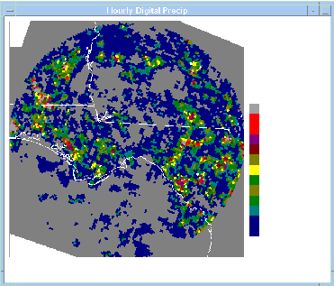
Figure 2 contains all hours from Regime 8. In summary, Regime 8 limits convective development to northern Florida mainly east of Tallahassee, and also confines it to very near the coastline west of Tallahassee. Little activity is found in the offshore waters.
3.1.b All Regimes
This sample contains 276 days using all the days in June - August of 1996 - 1998. Of course, there are some missing hours here and there. For this case, we will show time of convective minimum, maximum offshore development, seabreeze initiation, and convective maximum.
Figure 3 shows the time of minimum convective development at 0500 UTC (0100 EDT). The land breeze is probably just getting underway and convection over land has mostly dissipated. Maximum offshore development is depicted in Fig. 4 which occurs around 1400 UTC (1000 EDT). The activity is strikingly restricted to the Gulf of Mexico. Just a few hours later (Fig. 5), at 1700 UTC (1300 EDT), convection is beginning along most of the northwest Florida Gulf coast. Very little development is found in Alabama or Georgia. Finally, Fig. 6 shows development at 2000 UTC (1600 EDT); activity at its maximum. The seabreeze is active all along the coast and has migrated inland considerably in some places. Notice the lack of activity near Tallahassee which may be, in part, due to HDP hybrid scan strategy near the radar, but also due to the concave coastline which causes a weakened seabreeze due to the diffluent flow pattern. Florida State University students over the years have coined the phrase, the 'Tallahassee Effect', i.e., Tallahassee never seems to get its share of convection.
3.2 Beam Blockage
Radar Beam blockage problems associated with mountainous terrain are well known. This is a common problem with WSR-88Ds located in the western U.S. While assembling the mean radar maps using HDP data for the summers of 1996 and 1997, a quadrant of reduced radar-derived precipitation was found across southwest Georgia.
Figure 7 is the HDP composite for the Tallahassee WSR-88D for the period January through March 1998 for all hours and all days. Wintertime precipitation is predominantly stratiform, which produces a 'bright band' ring around the radar site. However, the complete northeast quadrant of the Tallahassee radar is significantly blocked. The 22-story Florida State Capitol building is observed with a spike at approximately 50 degrees.
It was determined that hills within 3 to 4 nm of the radar were providing a significant beam blockage problem at 0.5 degrees elevation. It has been estimated that as much as 40% of the power transmitted at 0.5 degrees may be blocked and absorbed by the nearby hills.
A certain amount of beam blockage is found on all WSR-88D radars. Another example of beam blockage is shown in Fig. 8 from the Jackson, MS WSR-88D radar. This example is a two-month wintertime sample from 1998. Significant beam blockage is found in the entire eastern semicircle.
3.3 Forecast Verification
National Weather Service public zone forecasts are issued twice per day with updates and amendments as needed. These public forecasts contain predictions for sky condition, temperature, winds, and a probability of precipitation (POP). The definition of POP is the average point (location) probability of a measurable amount of precipitation for the local area (or zone) during the time periods of the forecasts (Hughes 1980). However, precipitation is measured at only a few discrete locations in the forecast area. Also, summertime precipitation is not uniform across a region. It can be shown that point probability of precipitation is almost always smaller than the areal probability; it can never be larger, and they are equal only when the expected areal coverage is one, i.e., 100% (Hughes 1980 and others). For verifications purposes, we can assume that point coverage and areal coverage are approximately equal.
Therefore, HDP daily composites can be used for this purpose. By summing the hourly HDP radar-derived precipitation for the forecast period, it is possible to calculate an areal percentage of activity and verify against the forecast POP.
4. SUMMARY
This paper has shown examples of the realm of possibilities that exist with HDP data. Only by constructing the composite images did we discover the range blockage problem on the Tallahassee WSR-88D. We are currently working with the Operational Support Facility (OSF) in Norman, OK to minimize this effect.
Offices, with the cooperation of their associated RFCs, can obtain their 88D's HDP data and prepare radar climatologies as described in this paper. Given the software, the time involved is little compared to the pay backs in forecaster awareness and understanding of local convective climatology.
5. REFERENCES
Blanchard, D.O., and R.E. Lopez, 1985: Spatial patterns of convection in south Florida, Mon. Wea. Rev., 113, 1282-1299.
Camp, J.P., A.I. Watson, and H.E. Fuelberg, 1998: The diurnal distribution of lightning over north Florida and its relation to the prevailing low-level flow, Wea. Forecasting, 13, 729-739.
Gentry, R.C., and P.L. Moore, 1954: Relation of local and general wind interaction near the sea coast to time and location of airmass showers, J. Meteor., 11, 507-511.
Gould, K.J., and H.E. Fuelberg, 1996: The use of GOES-8 imagery and RAMSDIS to develop a sea breeze climatology over the Florida panhandle, Proceedings, Eight Conference on Satellite Meteorology and Oceanography, Jan-Feb 1996, Atlanta, GA, Amer. Meteor. Soc., 100-104.
Hughes, L.A., 1980: Probability forecasting - reasons, procedures, problems, NOAA Tech. Memo. NWS FCST 24, Meteorological Services Division, Silver Spring MD, 92pp.
Watson, A.I., and D.O. Blanchard, 1984: The relationship between total area divergence and convective precipitation in south Florida, Mon. Wea. Rev., 112, 673-685.
Fig 1. Regime 8 composite image for 2200 UTC for the period 1996-1998.
Fig 2. Regime 8 composite image for all hours for the period 1996-1998.
Fig 3. Composite image for entire sample at 0500 UTC (0100 EDT) for the period 1996-1998.
Fig 4. Composite image for entire sample at 1400 UTC (1000 EDT) for the period 1996-1998.
Fig 5. Composite image for entire sample at 1700 UTC (1300 EDT) for the period 1996-1998.
Fig. 6. Composite image for the entire sample at 2000 UTC (1600 EDT)
Fig. 7. Composite HDP image for the Tallahassee WSR-88D radar for the period, January - March 1998.
Fig. 8. Composite HDP image for the Jackson, MS WSR-88D radar for the period, January and February 1998.


 Follow us on YouTube