Andrew I. Watson*, Todd P. Lericos, Jeffery D. Fournier,
NOAA/National Weather Service
Tallahassee, Florida
and
Edward J. Szoke
NOAA/Forecast Systems Laboratory
Boulder, Colorado
1. INTRODUCTION
Quasi-geostrophic (QG) Theory is one of the most important concepts, put forth in the late 1940s (Charney 1948), for interpreting the present state of the atmosphere, and evaluating short-term tendencies of synoptic scale systems. It is elegant in its simplicity and usefulness, though in its simplicity also lies drawbacks and problems. In spite of these drawbacks, QG Theory is still very useful, especially to the new student of atmospheric processes.
The Forecast System Laboratory (FSL), in cooperation with the National Weather Service (NWS), has developed the Display 3-Dimensional workstation (D3D). D3D allows users to view real-time meteorological model data in a three-dimensional interactive display. D3D has evolved from the WFO-Advanced D2D system, which is currently the operational interactive display software on the Advanced Weather Interactive Processing System (AWIPS) installed in all NWS forecast offices (WFOs).
Since atmospheric processes are inherently three-dimensional, it was natural for FSL to extend its D2D and WFO-Advanced system to three dimensions. At the core of D3D capability is the Vis5D software developed at the University of Wisconsin.
The NWS has begun establishing D3D test sites at several WFOs in the NWS Southern Region, including WFO Tallahassee, as well as Regional Centers. D3D was developed primarily on HP workstations, but now has been ported to PC/Linux platforms, a convenient and low-cost workstation.
This paper will show how D3D can be used in a training environment. The terms in the QG omega equation, such as temperature advection and vorticity advection, can be visualized and related to vertical motion (omega). Other quantities such as potential vorticity will also be examined.
2. QG THEORY
In QG Theory, the primary horizontal circulation is defined by the geostrophic wind, which remains in hydrostatic and thermal wind balance. The secondary ageostrophic circulation is composed of both a horizontal component (an order of magnitude weaker than the geostrophic wind) and a vertical component. Assumptions in QG Theory are: synoptic scale motions, hydrostatic balance, geostrophic wind, advection by the geostrophic wind, no friction or terrain, a constant Coriolis parameter, adiabatic motion (no radiation, latent heat or sensible heat release), the ageostrophic wind is much less than geostrophic wind, and parcel accelerations are approximated by geostrophic accelerations. QG Theory reduces the governing equations to a set of easily understood equations, which are applicable to forecasting the weather, and which provide a method for understanding some of the complexities of the atmosphere.
3. QG OMEGA EQUATION
One form of the QG Omega equation is:
![]() (1)
(1)
Vertical motion is forced by vertical variations of geostrophic vorticity advection, and horizontal variations in geostrophic temperature advection. In the following sections, we will show how D3D can be used, in both operational and training environments, to visualize terms such as temperature advection and vorticity advection in the QG Omega equation.
4. CASE STUDY: 4 May 1999
To fully appreciate the advantages of D3D, we focus our attention on 4 May 1999, the day after the devastating tornado outbreak on the Southern Plains. A strong jet streak has moved into the southern Rockies, with the nose of the jet moving through the base of the trough producing a strong surface low pressure system in the central Great Plains.
We will use D3D to analyze this situation, illustrating how it could be used in a training situation. Numerical model data can be selected using the 3D Volume Browser window (Fig. 1). Following the selection of the model desired, various fields can be examined as 3-dimensional surfaces, cross sections, or plan views. Three dimensional rendering can be obtained by selecting isosurface in the 3D Volume Browser. An isosurface is the 3D contour surface of a field at a particular value. It depicts the volume bounded by that value, allowing one to visually depict the field’s 3D structure at any desired viewing angle. Isosurface skin values and presentation colors can easily be modified.
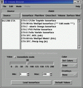
Figure 1. D3D Volume Browser window showing model source and available fields.
Planview permits viewing of a horizontal section of data. Cross section allows vertical cross sections of data to be viewed. Volume rendering is a technique for displaying a 3D field as a semi-transparent colored fog. Surface allows viewing data on the 3D topography surface, and wind allows viewing of horizontal and vertical cross sections of wind data in both the 3D volume and at the surface.
The Eta 80-kt jet streak isosurfaces are shown in Figs. 2 and 3 for 1200 UTC 4 May 1999. Since it is very difficult to get a perspective of a 3D surface on a 2D sheet of paper, especially using only shades of gray, a top quarter view (Fig. 2) and a view from the south (Fig. 3) are provided for comparison. Since the jet streak is aloft, some parallax error is introduced. However, the 80 kt jet streak is a significant volume of air, moving southeastward into the trough located in the southern Rockies. To show surface features, sea-level pressure is plotted at 1-mb increments. Notice that the Gulf of Mexico is open, with moderate southerly flow pushing warm moist air northward into Canada. An elongated low pressure system is situated in the Upper Plains, defining the boundary between warm moist Gulf air and Pacific maritime air spilling across the Rockies. The depth of the 80-kt jet streak is evident in Fig. 3, dipping as low as 500 mb. The vertical coordinate is pressure, (not the log of pressure). The top of the volume is 100 mb in all displays.
According to QG Theory, both differential horizontal warm air advection and vertical differential positive vorticity advection contribute to upward vertical motion. In equation (1), a LaPlacian operator acts on the temperature advection term, which complicates the situation. However, we can examine the simple quantities of warm air temperature advection and positive vorticity advection.
The associated Eta warm air advection is shown in Fig. 4, while Fig. 5 illustrates positive vorticity advection. Warm air advection is concentrated on the eastern extension of the jet streak, and extends from Mexico to Canada. Vorticity advection (Fig. 5) covers much the same area.
Having seen the results of the thermal and vorticity advection terms, we look at upward vertical motion. Figure 6 shows the large region of upward vertical motion (omega) associated with the deepening surface low and jet streak. Eta ascent exceeding –4 :bar s-1 covers much of Plains States.
5. POTENTIAL VORTICITY
From the divergent vorticity equation, it can be shown that
![]()
(2)
where 0 = absolute vorticity and,
M2/Mp = static stability.
From the above equation, the most common form of Isentropic Potential Vorticity (IPV) is:
![]()
(3)
Since IPV is a conservative property, parcels that descend from the stratosphere into the less stable troposphere must increase their absolute vorticity to conserve potential vorticity.
Figure 7 depicts an IPV anomaly, a stratospheric intrusion into the troposphere. The IPV isosurface of 2 units or greater is shown. Potential vorticity advection into the troposphere, can precede the increase in relative vorticity and cyclogenesis by 12 hours or more.
6. SUMMARY
A presentation in a preprint volume cannot adequately depict this visually powerful tool. With the use of a mouse, any perspective can be examined and shifted fluidly and continuously to another perspective. The forecaster can look around corners, zoom in, zoom out, loop, change colors, change parameter settings, and even change the opaqueness of a field.
Only a small portion of the 3D Volume Browser has been examined in this paper. Cross section and plan views can be easily shifted from one level to another. Other sampling techniques include a sounding and hodograph viewing mode. Selecting the probe mode makes it possible to inspect data values at any location in the grid. Finally, wind trajectories can trace air motions in time through the 3D volume.
The NWS Tallahassee has placed the D3D PC/Linux machine in a prominent place in the operations area. It has been found to be more useful during the winter and transition months. It has not become a replacement for D2D, but is used as a complement to D2D. We look forward to integrating D3D into office operations and hope to see D3D as an option on all of the WFO AWIPS workstations in the very near future.
7. REFERENCES
Charney, J.G., 1948: On the scale of atmospheric motion. Geofys. Publ., 17, No 2.
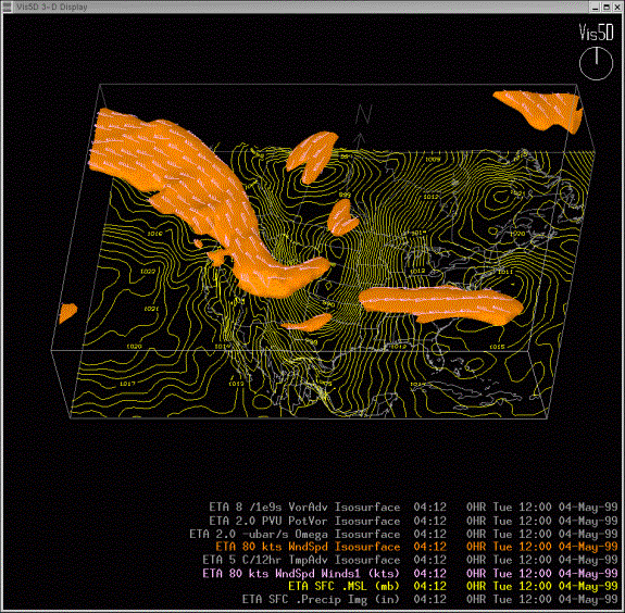
Figure 2. D3D rendering of the Eta 80-kt jet streak isosurface at 1200 UTC 4 May 1999. Surface pressure contours at 1-mb increments are also shown.

Figure 3. Same as Fig. 2, except looking north into the volume. Topography is shown at bottom of figure.
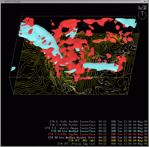
Figure 4. Same as Fig. 2, except with the addition of the Eta 7º C/12 h or greater temperature advection isosurface (red).
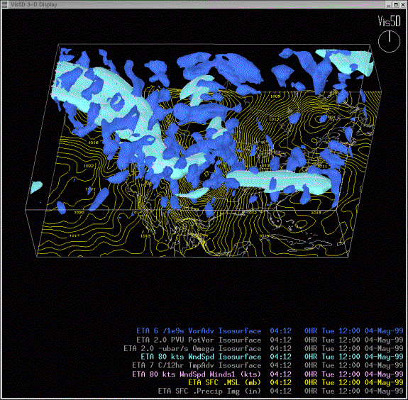
Figure 5. Same as Fig. 2, except with the addition of the Eta 4 x 10⁻⁹ m s-1 or less vorticity advection isosurface (blue).
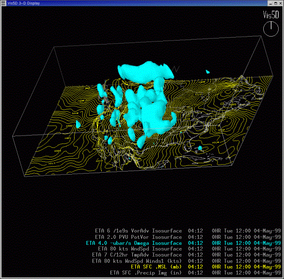
Figure 6. D3D rendering of the Eta ascent exceeding -4 ubar s-1 omega isosurface at 1200 UTC 4 May 1999.
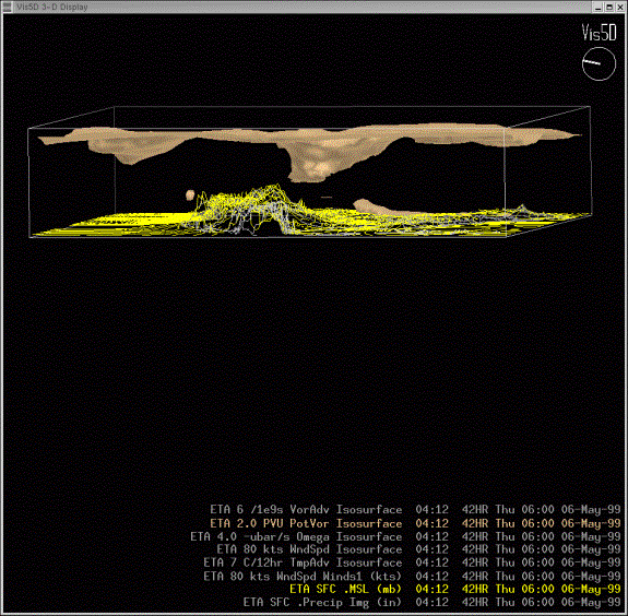
Figure 7. D3D rendering of the 2 and greater potential vorticity units (PVU) isosurface for the 42-hr forecast at 0600 UTC 6 May 1999.


 Follow us on YouTube