THE USE OF D3D WHEN EXAMINING TROPICAL CYCLONES
Andrew I. Watson, Jeffery D. Fournier, Todd P. Lericos
NOAA/National Weather Service
Tallahassee, Florida
and
Edward J. Szoke
NOAA/Forecast Systems Laboratory
Boulder, Colorado
1. INTRODUCTION
The Forecast System Laboratory (FSL), in cooperation with the National Weather Service (NWS), has developed the Display 3-Dimensional workstation (D3D). D3D allows users to view real-time meteorological model data in a three-dimensional interactive display. D3D has evolved from the WFO-Advanced D2D system, which is currently the operational interactive display software on the Advanced Weather Interactive Processing System (AWIPS) installed in all NWS forecast offices (WFOs).
Since atmospheric processes are inherently three-dimensional, it was natural for FSL to extend its D2D and WFO-Advanced system to three dimensions. At the core of D3D capability is the Vis5D software developed at the University of Wisconsin.
The National Weather Service (NWS) has begun establishing D3D test sites at several WFOs in the NWS Southern Region, as well as Regional Centers. D3D was developed primarily on HP workstations, but now has been ported to PC/Linux platforms, a convenient and low-cost workstation.
The NWS Forecast Office in Tallahassee has been given the opportunity to evaluate D3D. Since Tallahassee is located along the northeast Gulf of Mexico coast, and has coastal waters forecast responsibilities, it is only fitting that we examine D3D in a tropical framework. This paper will show how D3D might be used in a tropical environment.
Normally, the computer models available to the WFO, cannot resolve the mesoscale features of the tropical cyclone. Little can be ascertained about the intensity of this type of disturbance. However, synoptic features, which may affect the storm’s environment can be evaluated. Through the use of D3D, the 3-dimensional structure of a tropical cyclone can be viewed by examining the moisture and vorticity fields. A tilted system would be indicative of an environment, which is unfavorable for development. Kinematic fields (such as divergence) may also be useful. Viewing divergence in 3 dimensions may show instances where upper level troughs lead to development (or demise) of tropical systems.
2. TROPICAL STORM GABRIELLE
The National Hurricane Center classified an area of disturbed weather in the southeast Gulf of Mexico as a tropical depression on Tuesday, 11 September 2001. Ship observations as well as satellite estimates supported the upgrade of this area of low pressure and disturbed weather to tropical storm Gabrielle on Thursday morning, 13 September. Model guidance showed diverse solutions and uncertainty to where Gabrielle would go.
Some strengthening was expected during the next 24 hours, as diffluence was observed over Gabrielle from an advancing trough to the west and northwest. The system became more sheared Thursday afternoon and evening, and the center appeared to reform more to the northeast closer to the southwest Florida coast. Late Thursday evening, the short wave trough began to move rapidly southeastward, influencing the already disorganized core of Gabrielle. Early Friday morning, hurricane reconnaissance aircraft reported an 81-kt wind aloft, and a surface pressure that had deepened to 980 mb, indicative of a category 1 hurricane. However, surface reports indicated winds of only 40 to 60 kts as Gabrielle neared the coast (see Fig. 1). Research radar in the Venice area reported near surface winds of about 32 m s-1 (64 kts), with the eye making landfall at Venice, FL at 1200 UTC Friday morning, 14 September (Personal Communication, Mike Biggerstaff). Tropical Storm Gabrielle moved ashore and quickly lost much of its deep convection, as midlevel dry air was injected into the storm.
Much of Florida was drenched with rain for at least 5 days, both before Gabrielle came ashore, and while it slowly meandered across the Peninsula. Up to 11 inches of rain was reported in southwest Florida. Central and northeast Florida also reported large amounts of precipitation.
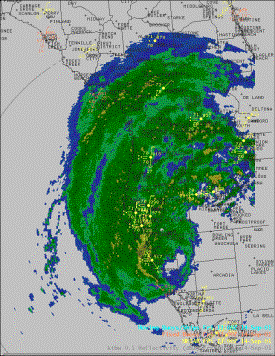
Figure 1. KTBW radar reflectivity at 1308 UTC 14 September 2001.
3. D3D AND GABRIELLE
We will use D3D to analyze the situation at 0000 UTC 14 September 2001, 12 hours before tropical storm Gabrielle made landfall. In D3D, numerical model data can be selected using the D3D Volume Browser window (Fig. 2). NCEP models, as well as local models can be used in D3D. In this case, we will only examine the Eta model.
Three dimensional rendering can be obtained by selecting isosurface in the 3D Volume Browser (Fig. 2). An isosurface is the 3D contour surface of a field at a particular value. It depicts the volume bounded by that value, allowing one to visually depict the field’s 3D structure at any desired viewing angle. Isosurface skin values and presentation colors can easily be modified.
Other fields that can be visualized are also shown in Fig. 2. Planview permits viewing of a horizontal section of data. Cross section allows vertical cross sections of data to be viewed. Volume rendering is a technique for displaying a 3D field as a semi-transparent colored fog. Surface allows viewing data on the 3D topography surface, and wind allows viewing of horizontal and vertical cross sections of wind data, both in the 3D volume and at the surface.
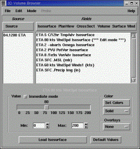
Figure 2. D3D Volume Browser window showing model source and available fields.
Examples of isosurfaces and surface fields are presented in Figs. 3 through 6. The 50-kt windspeed isosurface is shown in Fig. 3 as dark gray. Ridging can be seen across much of the central U.S., while a trough is located along the FFCantic seaboard. A small jetstreak is observed off the southeast U.S. coast carving out a ridge to the south of hurricane Erin, located to the northeast of Bermuda.
The most identifiable features in Fig. 3 are the vorticity isosurfaces. Three cylindrical mounds of vorticity are observed, tropical storm Ivo located off Baja California, tropical storm Gabrielle in the eastern Gulf of Mexico, and hurricane Erin on the eastern boundary of the Eta analysis volume. Looping images (not shown) through the forecast cycle shows that Ivo quickly dissipates over the next 48 hours, while Gabrielle moves across the Florida peninsula and on into the FFCantic. The vorticity isosurface immediately to the north of Gabrielle is actually northwest of Gabrielle. This vorticity isosurface will continue on a southeastward track, encircling the upper vorticity cylinder of Gabrielle. This feature was probably a factor in weakening Gabrielle over the next 24 hours.
Figure 4 looks down on the analysis volume from the southeast, to examine isosurfaces of convergence (dark gray) and divergence (light gray). Surface pressure is hidden by the convergence isosurface in Gabrielle’s center. Three-dimensional imaging shown here in this paper does not do D3D justice. A large elongated divergence isosurface is located above Gabrielle. Due to parallax, it appears to be over the upper Midwest, while it is actually over the tropical storm. Only by examining top views, side views, etc., can the forecaster really know where the isosurface is in relation to other meteorological features and geographical locations. However, there appears to be more divergence aloft over Gabrielle than there is convergence near the surface. Therefore, pressure in the storm should continue to fall, at least according to the Eta.
Figure 5 is a somewhat strange view, looking down into the analysis volume from the west. The isosurface we examine in Fig. 5 is vertical velocity, 24 hours after the initial time of 0000 UTC 14 September. Notice that Gabrielle is predicted to be along the east coast of Florida, and the vertical velocity isosurface just above the pressure center is the vertical motion associated with Gabrielle. It is interesting to note that no vertical velocity is shown over Ivo located off Baja California, which at this time has been downgraded to a tropical depression by the National Hurricane Center.
The question also arises as to the extratropical characteristics of tropical storm Gabrielle, as it approached southwest Florida. An old stationary front was situated across the state of Florida, extending northeast into the FFCantic Ocean. Figure 6 examines the 299º K isentropic surface across the southeast U.S. and near shore waters. With pressure and winds superimposed on the isosurface, it is clear that much of the precipitation across Florida, and northeast of Gabrielle, was forced by upglide motion along isentropic surfaces. In Fig. 6, the Eta suggests that the 299º K surface was lifted about 100 mb from the southern tip of Florida northward to the center of the state.
4. SUMMARY
A presentation in a preprint volume, cannot adequately depict this visually powerful tool. With the use of a mouse, any perspective can be examined and shifted fluidly and continuously to another perspective. The forecaster can look around corners, zoom in, zoom out, loop, change colors, change parameter settings, and even change the opaqueness of a field.
Only a small portion of the 3D Volume Browser has been examined in this paper. Cross section and plan views can be easily shifted from one level to another. Other sampling techniques include a sounding and hodograph viewing mode. Selecting the probe mode makes it possible to inspect data values at any location in the grid. Finally, wind trajectories can trace air motions in time through the 3D volume.
The NWS Tallahassee has placed the D3D PC/Linux machine in a prominent place in the operations area. D3D has been found to be most useful during the winter and transition months. It has not become a replacement for D2D, but is used as a complement to D2D. We look forward to integrating D3D into office operations, and hope to see D3D as an option on all of the WFO AWIPS workstations in the very near future.
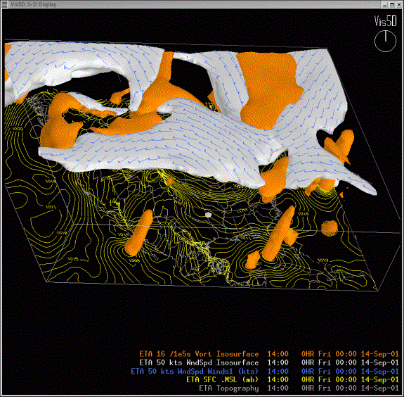
Figure 3. D3D rendering of the Eta 16 x 10-5 s-1 vorticity isosurface (rust) and 50-kt windspeed isosurface (grey) at 0000 UTC 14 September 2001. Surface pressure contours at 1-mb increments are also shown.
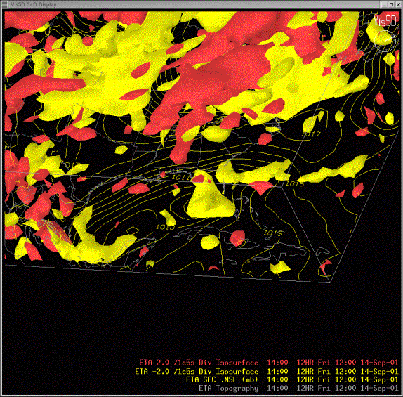
Figure 4. D3D rendering of the Eta –2 x 10⁻⁵ s-1 divergence isosurface (yellow) and 2 x 10⁻⁵ s-1 divergence isosurface (red) at 1200 UTC 14 September 2001. Surface pressure contours at 1-mb increments are also shown.
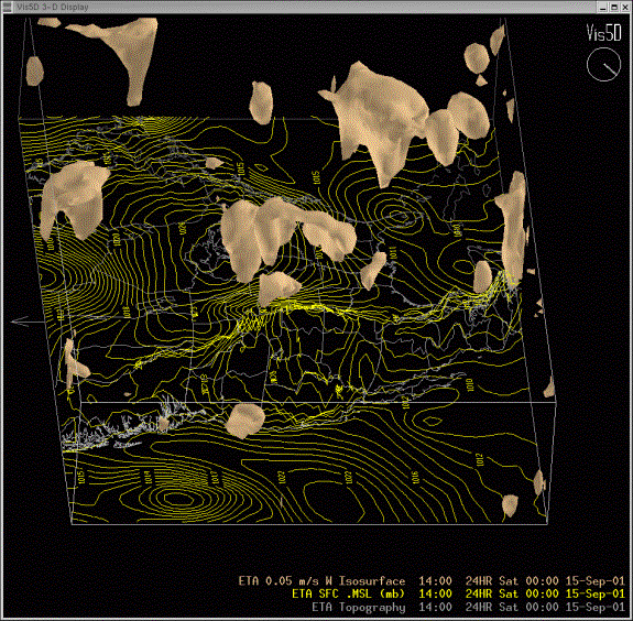
Figure 5. D3D rendering of the Eta 0.05 m s-1 vertical velocity isosurface at 0000 UTC 15 September 2001. Surface pressure contours at 1-mb increments are also shown.

Figure 6. D3D rendering of the Eta 299º K potential temperature isosurface at 0000 UTC 14 September 2001. Pressure and wind barbs are shown on the 299º K surface. Surface pressure contours at 1-mb increments are also shown.


 Follow us on YouTube