The Tallahassee National Weather Service Office has warning responsibility for 47 counties in northwest Florida, southwest Georgia, and extreme southeast Alabama. Figure 1 shows the Tallahassee county warning area (CWA) with WSR-88D radar locations and main cities. Coffee County, Alabama is approximately 115 nm northwest of the National Weather Service (NWS) WSR-88D (KTLH) in Tallahassee. Ben Hill County, Georgia is approximately the same distance to the north. However, the NWS office in Tallahassee enjoys the luxury of having an Associated Principal User Processor (APUP) from the Eglin AFB, Florida (KEVX) Department of Defense (DoD) WSR-88D located 84 nm west of KTLH. Two additional DoD radars are located in the KTLH CWA; the Fort Rucker (KEOX) radar north of Dothan, Alabama, 84 nm northwest of KTLH, and the Moody AFB (KVAX) radar near Valdosta, Georgia, 74 nm east-northeast of KTLH.
During January 1997, two severe weather events occurred near Dothan, Alabama which exemplified the importance of coordination and use of all the available WSR-88Ds in the region. This paper briefly describes the two convective events and discusses the coordination agreements undertaken by the NWS and DoD installations in this area.
The WSR-88D Algorithm Testing and Display System (WATADS), developed by the National Severe Storms Laboratory (NSSL) and the WSR-88D Operational Support Facility (OSF), was used to analyze and display these events (Staff 1997).
During January 1997, several severe convective weather systems moved across southeast Alabama and the Florida panhandle. An F2 tornado was reported on 5 January destroying several homes and barns, producing a 6-mile damage path near Newville, Alabama (see path in Fig. 1 east of KEOX). The same storm system produced a bow-echo structure which ripped through Geneva (west of Dothan) and Houston Counties, and across the Dothan metropolitan area. Damaging straight-line winds knocked down countless trees, powerlines, and damaged homes and businesses.
On the evening of 24 January, another storm system moved across Dothan again, causing significant wind damage. The Fort Rucker WSR-88D showed a classic hook echo structure including a Tornado Vortex Signature (TVS) with this storm. There were no reports of a tornado touchdown with this event.
Severe convective cells developed in a squall line which moved across extreme southeast Alabama in advance of a polar front of Pacific origin in the early morning hours of Sunday, January 5, 1997. A persistent mesocyclone was observed across Geneva County, prompting a severe thunderstorm warning to be issued by NWS KTLH. The nearby Fort Rucker radar was inoperative during this event. The situation as of 1246 UTC is shown in Fig. 2. At this time, the tornado was probably on the ground in the echo north of Dothan. Additionally, just west of Dothan was another weakly rotating cell with a bow-echo structure. Operationally on this day, the KEVX (Eglin AFB radar) was used since it is 50 nm south of the action. However, no Archive-II data were recorded from this radar.
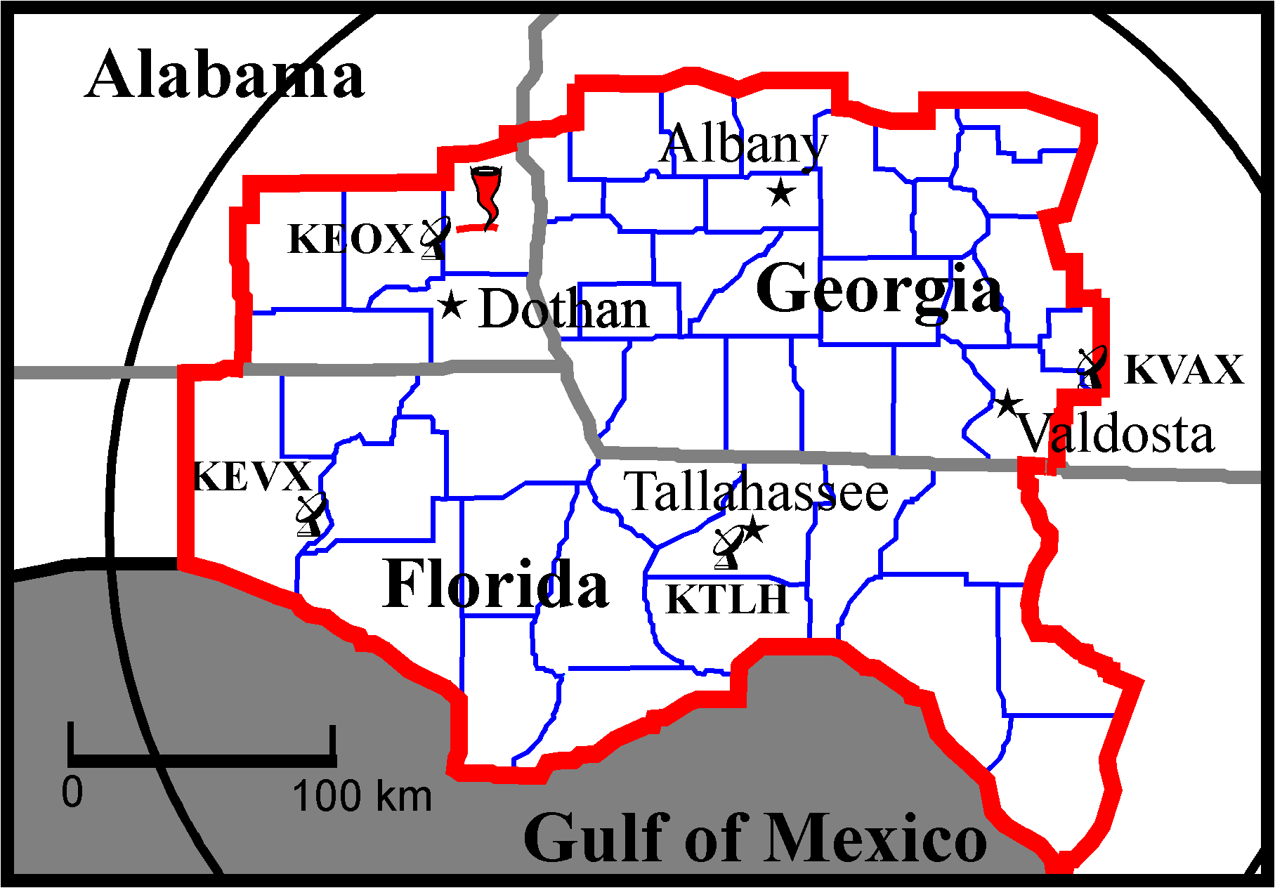
Figure 1. Tallahassee NWSO County Warning Area with locations of WSR-88D radars, cities, and tornado of 5 January 1997.
A rapidly moving long-wave trough, and a low-latitude short-wave coupled with rapidly developing low pressure in the midwest provided the environment for an intense squall line to develop across Alabama, northwest Florida, and Georgia. Several storms spawned mesocyclones within this line of convection. One particular mesocyclone moved across the Fort Rucker military reservation, and again through the Dothan metropolitan area. At 0305 UTC, the KEOX (Fort Rucker) radar (Fig. 3a) showed a hook echo structure containing a moderate mesocyclone and weak meso-anticyclone. A TVS was also detected. Figure 3b is a reflectivity image from the KTLH radar at the same time showing, a much less intense and different structure. A mesocyclone was detected, along with an inflow notch, but the echo was blurred by beam filling.
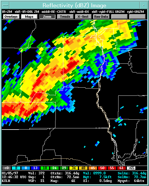
Figure 2. KTLH WSR-88D reflectivity image for 5 January 1997 at 1246 UTC.
Cases such as the ones discussed here serve to remind NWS offices with warning responsibility that one radar view of a given storm may not be enough. To properly diagnose the potential for severe weather, it should be standard practice to obtain real time data from adjacent WSR-88Ds. The storm of January 24-25 is a case in point. While the KEVX radar gave a number of indications of the storm’s severity, it did not show critical details of the storm structure, as did the KEOX radar. The Tallahassee (KTLH) radar was just too far away.
The January 5th case did not allow for such comparison of radars. However, it is clear that the availability of KEVX radar data can make a critical difference in the decision making for the NWS forecaster.
The NEXRAD system was intended to jointly serve the broad needs of the NWS, the DoD, and the FAA. While the roles of each of these organizations are distinct, it is obvious that cases will occur where cooperation may be of great benefit in the services provided by each. To this end, efforts have been made to increase the coordination between the NWSO in Tallahassee and the responsible DoD weather offices.
NWS Tallahassee management has, on several occasions, met with weather personnel from these installations to discuss improvements in operational coordination. Specifically, there is agreement that the NWSO will coordinate as much as possible with the Base Weather Stations when considering or issuing warnings. At Fort Rucker and Eglin AFB, there is now a heightened understanding of the needs of the NWSO. Likewise, the NWSOs must be aware of and sensitive to the weather needs of the DoD bases within the CWA. Most importantly, efforts must be continued to improve the frequency and timeliness of coordination between the NWSO and the DoD staffs.
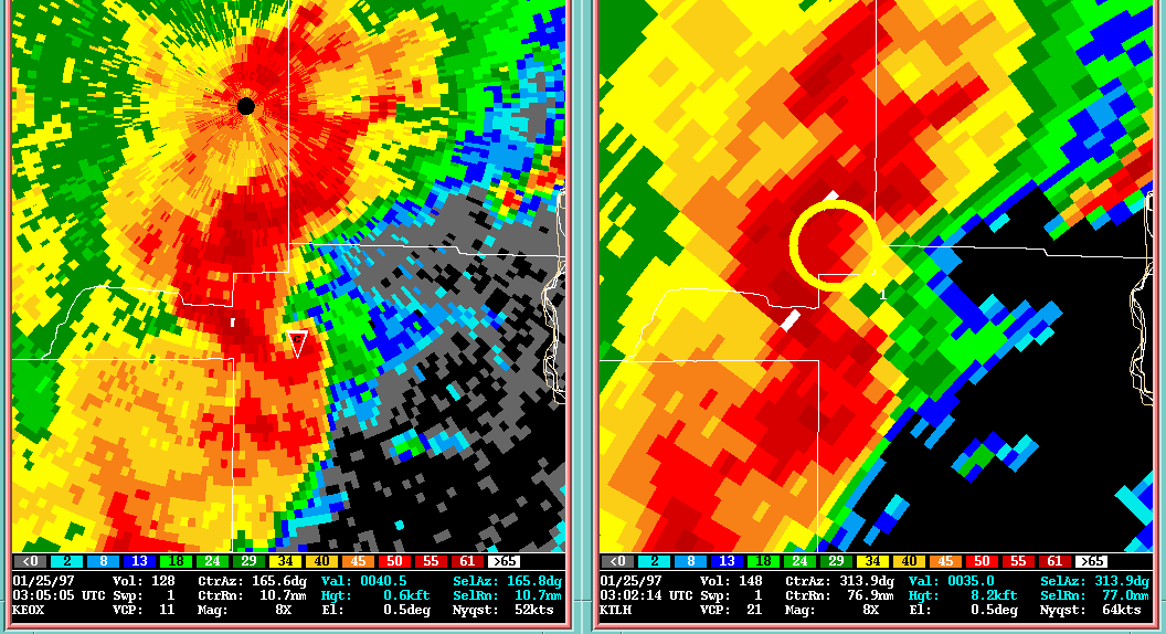
Figure 3a (left). Fort Rucker (KEOX) reflectivity image at 0305 UTC, 25 January 1997.
Figure 3b (right). Tallahassee (KTLH) WSR-88D reflectivity image at 0302 UTC, 25 January 1997.
Staff, Stormscale Research and Applications Division, 1997: WSR-88D Algorithm Testing and Display System (WATADS) Reference Guide. National Severe Storms Laboratory (NSSL), Norman, OK.


 Follow us on YouTube