National Weather Service United States Department of Commerce
Precipitation and Flash Flood Climatology of the WFO Morristown Hydrological Service Area
by
David M. Gaffin and David G. Hotz
 

1. Introduction


As a result of the Modernization and Associated Restructuring (MAR) of the National Weather Service (NWS), a new Warning and Forecast Office (WFO) was established at Morristown, Tennessee in 1995. This new weather office is responsible for issuing public forecasts and severe weather warnings for its County Warning Area (CWA) and hydrological forecasts and warnings for its Hydrological Service Area (HSA), which includes most of east Tennessee, parts of southwest Virginia and parts of extreme southwest North Carolina (Fig. 1). In addition, forecasters at WFO Morristown are responsible for issuing quantitative precipitation forecasts (QPF) for the river basins (Table 1) of the HSA, which includes all of east Tennessee and parts of southwest Virginia, western North Carolina, and northern Georgia (Fig. 2). To support the local flash flood warning program, local forecasters have access to the Integrated Flood Observing and Warning System (IFLOWS), which is a network of river and rain gauges (Fig. 3, Table 2) which helps forecasters monitor smaller streams across the CWA which flood quickly during heavy rains.


Since WFO Morristown was not a pre-established weather forecast office, little, if any, knowledge of the local and regional weather variations were known. The southern Appalachian mountains, with peaks around 6500 feet MSL, create a significant impact on the local precipitation patterns and on the local temperatures as well (Gaffin, 1999). To help forecasters gain a fundamental understanding of the unique forecast problems of the local area, a precipitation and flash flood climatology is compiled here for the WFO Morristown HSA, similar to the Gaffin and Lowery (1996) study of the NWSFO Memphis CWA. This climatology includes a study of the local topography, spatial distribution of normal precipitation, local flash flood statistics, frequency of heavy rain, and the synoptic patterns and mesoscale parameters which are typical of heavy rain events across the local area.


2. Data and Analysis
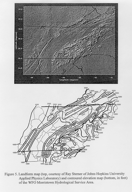
 

Most of the data used in this study were obtained from the National Climatic Data Center (NCDC) in Asheville, North Carolina. Flash flood statistics were compiled between 1960 and 1997 from reports in Storm Data published by NCDC. Precipitation 'normals' (thirty year averages from 1960-1990) for most of the cooperative stations across the WFO Morristown HSA (Fig. 4) were obtained from the Climatography of the United States (No. 81) series published by NCDC. These normals were used to construct the maps of the spatial distribution of monthly precipitation across the HSA.


The Solar and Meteorological Surface Observation Network CD-ROM and Hourly United States Weather Observations CD-ROM from NCDC were used to extract the hourly precipitation data from 1960 through 1995 which were then used to determine heavy rainfall events across the HSA. Using these dates, Daily Weather Maps, which show synoptic surface and 500 millibar features, were then obtained from the Climate Analysis Center in order to analyze and classify the synoptic patterns which created the heavy rain events across the HSA. Additional parameters of these heavy rain events were extracted from area soundings which were archived on the Radiosonde Data of North America CD-ROM produced by NCDC.


3. Topography


The topography across the WFO Morristown HSA varies significantly and has a major impact on the precipitation climatology and flash flooding threat (Fig. 5). Mountainous terrain (with several peaks above 6000 feet MSL comprising the southern Appalachian chain) can be found across the eastern-most counties of the HSA along the Tennessee/North Carolina border. Despite the high elevations, several rivers in the HSA begin in western North Carolina and flow into east Tennessee. These rivers include the Nolichucky, French Broad, Pigeon, Little Tennessee, Hiwassee and Watauga rivers.


Just west of the Appalachian mountains lies the Great Tennessee Valley, which stretches from northwest Georgia northeast across east Tennessee into southwest Virginia. The elevation of this valley ranges from 800-1000 feet across southeast Tennessee and northwest Georgia to 1500-2000 feet across northeast Tennessee and southwest Virginia. Numerous ridges can be found in the valley with elevations up to 3000 feet. The main population centers of the HSA, including Chattanooga, Knoxville and the Tri-Cities, are located in the Great Tennessee Valley.


The terrain across southwest Virginia is mountainous with peaks over 4000 feet and valleys around 2200 feet. The Clinch and Powell mountains are narrow mountain ranges which stretch from northeast Tennessee into southwest Virginia and separate the watersheds of the Clinch and Powell rivers. Over the western section of the HSA lies the Cumberland Plateau, where the elevation generally rises around 500 to 1000 feet above the valley floor. The Sequatchie River Valley cuts through the Cumberland Plateau in the southwestern portion of the HSA with elevations generally around 1000 feet across the valley.


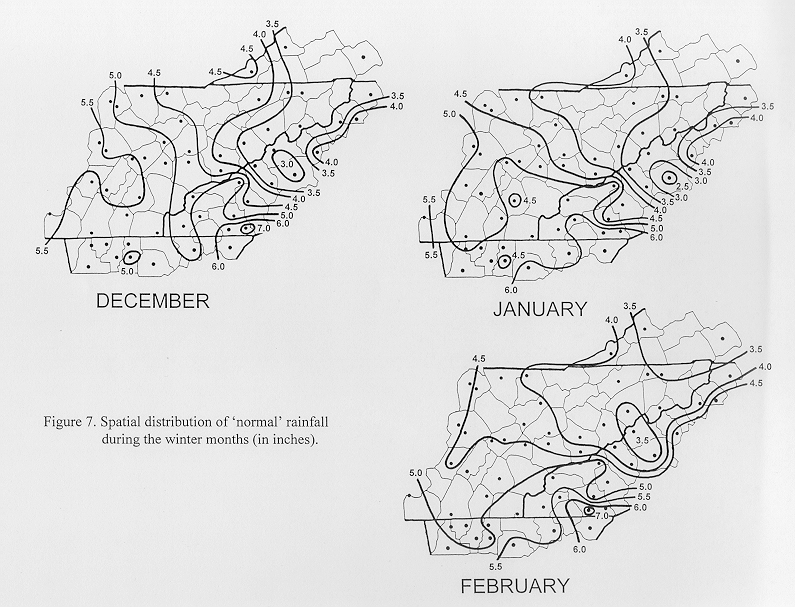
4. Normal Precipitation Distribution


A temporal distribution analysis was compiled for the WFO Morristown HSA by averaging the normals (30 year averages) from five stations that spatially represented the HSA: Chattanooga TN, Knoxville TN, Bristol TN, Oneida TN and Murphy NC. The results of this analysis (Fig. 6) revealed that March is the wettest month of the year across the HSA while October is the driest month. A secondary peak of rainfall can be seen in July when warm, moist air and orographical effects produce frequent thunderstorms over the area.


The annual normal precipitation map (Fig. 6) reveals a large variance in precipitation across the HSA, which is due in most part to the mountainous terrain of the southern Appalachian region. Southerly winds predominate across the southern Appalachians, bringing abundant moisture from the Gulf of Mexico and the Atlantic Ocean. Since the upslope flow of these southerly winds is greatest along and east of the spine of the Appalachian mountains, the annual precipitation is greatest across the far southeastern counties of the HSA in southwest North Carolina. Southerly winds are also generally upslope onto the Cumberland Plateau in the western portion of the HSA, which explains the higher annual precipitation amounts across the Plateau, especially near Monteagle in the southwestern corner of the HSA.


The lowest amount of annual precipitation occurs across northeast Tennessee and southwest Virginia (northern sections of the Great Tennessee Valley) as well as across portions of western North Carolina near Asheville. These areas are most affected by downsloping southerly winds into the Great Tennessee Valley off the spine of the Appalachian mountains. Also, the Asheville area is situated in the French Broad River Valley where downslope winds prevail throughout the year. This stabilizing downslope wind effect is also seen across the southern sections of the Great Tennessee Valley, where lower annual precipitation amounts are found around the Chattanooga area.


The analysis of normal monthly precipitation during the winter months (Fig. 7) and the spring months (Fig. 8) reveals that a large gradient exists from southwestern North Carolina and northeast Georgia into northeast Tennessee and southwest Virginia. This can be attributed to the typical storm track being farther south during the winter and early spring months. These synoptic systems produce a stronger southerly upslope flow into the mountains, while advecting abundant moisture northward from both the Gulf of Mexico and the Atlantic Ocean. Also, downslope flow from these stronger southerly winds occurs across northeast Tennessee and southwest Virginia, contributing to the lower precipitation amounts observed there.


During the summer months (Fig. 9), the highest elevations of east Tennessee, western North Carolina, and the Cumberland Plateau reveal a more pronounced higher average rainfall compared to the adjacent valleys across the HSA. This is likely due to the fact that synoptic systems primarily remain north of the area during the summer months with a weaker overall wind field observed. The weak upslope flow into the mountains and the elevated heating source of the mountains likely act as the dominant triggering mechanisms for thunderstorm development during the summer months. It is interesting to note that the wettest month for most of southwest Virginia and northeast Tennessee is July. This can be attributed to the weakening of the wind field and associated lessening of the downslope effects in the northern sections of the Great Tennessee Valley. Also, subtropical moisture finally spreads northward into the valley, allowing for heavier convective rains to occur.


The autumn months (Fig. 10) are typically the driest months of the year across the HSA. October is the driest month, when a large part of the northern and central sections of the Great Tennessee Valley generally have less than 3 inches of rain. High pressure systems usually dominate, bringing cool, dry conditions. However, precipitation can be highly variable during the autumn months. Land-falling tropical systems occasionally affect the southern Appalachians during the autumn months, bringing large rainfall amounts.


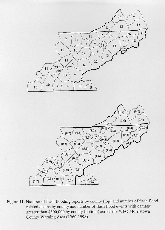
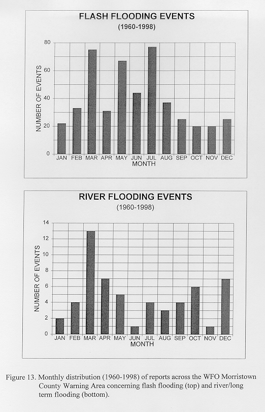
5. Flash Flood Statistics


Because of the mountainous terrain across the WFO Morristown CWA, flash flooding (defined by the National Weather Service as flooding that occurs in less than six hours) is a major concern for local forecasters. Flash flood statistics were compiled for the CWA between the years 1960 and 1998 using reports from Storm Data (published monthly by NCDC). A report from a single county was treated as a single separate report even though multiple counties may have been affected by the same thunderstorm or synoptic system. This was considered acceptable since multiple county reports were usually the result of significant synoptic-scale systems which deserve more emphasis in the statistics than isolated flash flooding created by a single pulse thunderstorm. Minor urban flooding reports were ignored, since this type of flooding can easily occur with minimal rain amounts due to man-made circumstances, such as clogged water drainages.


Figure 11 shows that flash flood reports are biased toward the populated areas of the CWA, as the top three counties reporting flash flooding contained the cities of Chattanooga, Knoxville, and the Tri-Cities. Hamilton county reported the most number of flash flood events across the CWA, which is likely due to urban development concentrated along the South Chickamauga Creek in Chattanooga. Also, Hamilton county reported the most number of flash flood events in the CWA with damage greater than 500,000 dollars (Fig. 11). In fact, two of these eight events in Hamilton county had damage estimates in excess of 5 million dollars.


There is also a bias toward mountainous areas. Wise county in southwest Virginia reported the third highest number of flash flood reports in the CWA with twenty-three. Also, Wise county had the second highest number (seven) of flash flood events with damage in excess of 500,000 dollars (Fig. 11). Carter county in northeast Tennessee (another mountainous county) had one of the more memorable flash flooding events. On January 7, 1998, seven people were killed and damages totaled in excess of 5 million dollars. The most destructive flash flooding event in the CWA occurred in Lee county Virginia where greater than 50 million dollars of damage was reported. Several flash flooding events in Sevier and Blount counties had damage estimates in excess of 5 million dollars, which is attributable to the large populated tourist areas at the entrance of the Smoky mountains.


In general, flash flood reports have increased the past decade (Fig. 12), due to an increased emphasis by the National Weather Service on volunteer spotter networks and warning verification. Also, the majority of flash flooding was reported during the afternoon and evening hours (Fig. 12), which is expected of convectively driven events. This bias toward convectively driven events can also be seen in the monthly statistics (Fig. 13). Flash flooding reaches a peak across the CWA during the late spring and summer months, with July being the most active month.


River or long-term (in excess of six hours) flooding statistics were also compiled from Storm Data to verify the monthly time period that this type of flooding usually occurs. Long-term flooding was usually only reported in Storm Data if it had a major impact on multiple counties. For this study, long-term flooding reports that affected multiple counties were tabulated as a single occurrence if they occurred with the same storm system during the same time period, instead of the county by county basis that was used with the flash flooding statistics. It was found that long-term flooding across the HSA occurs mainly during the winter and early spring months. This is likely due to the combination of snow melt and heavy long-term rainfall from synoptic-scale systems. Also, the loss of vegetation and low evaporation rates during the late fall months through the early spring months contribute to create higher rainfall runoff rates.


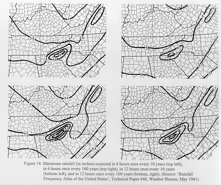
6. Frequency of Heavy Rain


Rainfall frequency information for the WFO Morristown HSA was obtained from the Rainfall Frequency Atlas of the United States, which was published by the Weather Bureau in 1961. While this publication is nearly 40 years old, it is the most current information available and is assumed to still be representative. Across the HSA, maximum rainfall amounts vary from 1.5" in three hours once every year to 10" in 24 hours once every one hundred years at any one given location (Table 3). The spatial distribution of the maximum expected rainfall (Fig. 14) shows that southwest North Carolina receives the most rainfall of any other area across the HSA. This is in agreement with the spatial distribution of normal rainfall across the HSA (Figs. 6-10), and is the result of topography creating upslope flow of moisture from the Gulf of Mexico and the Atlantic Ocean.


7. Synoptic Patterns of Heavy Rainfall


An important aspect of forecasting heavy rain events is recognition of the synoptic patterns that can create heavy rain for a given area. A heavy rain was defined for the WFO Morristown HSA as one that produced 3" or more in a 6 hour period or less and/or 4" or more in a 12 hour period or less. This is roughly the maximum amount of rainfall expected once every ten years at any given location across the HSA, according to the Rainfall Frequency Atlas of the United States. Thirty-five years of hourly precipitation data (1960-1995) were analyzed to determine the heavy rain dates from four stations, Chattanooga, Knoxville, Tri-Cities and Asheville, which spatially represent the HSA. A total of nineteen heavy rain events (Table 4) from three of the four stations were found to satisfy the heavy rain criteria, with the Tri-Cities airport not reporting a single heavy rain date. This was not unexpected since, as seen earlier with the spatial distribution of normal precipitation, the Tri-Cities area typically receives the least amount of rainfall across the HSA (due to the stabilizing downslope effects of the prevailing southerly winds).


The surface synoptic features and 500 mb patterns of each heavy rain event were then analyzed, using the Daily Weather Maps publication, in order to classify each event into one of four categories: synoptic, frontal, meso-high or tropical. This classification system was first defined by Maddox et al. (1979) where flash flood events across the United States were categorized into four categories: synoptic, frontal, meso-high and western. Since the 'western' category concerns flash flood events found in the western United States, this category was replaced by a 'tropical' category to account for flash flood events that were the direct result of tropical systems.


According to Maddox et al. (1979), 'synoptic' events were associated with an intense synoptic scale cyclone or frontal system and strong tropospheric wind fields. 'Synoptic' events normally developed in association with a quasi-stationary or slow-moving front, usually oriented from southwest to northeast, with a strong 500 mb trough moving east to northeast. Heavy rains occurred in the warm sector ahead of the front. 'Frontal' events were associated with a quasi-stationary or very slow-moving front, generally oriented west to east, embedded within weak large-scale patterns. Heavy rains occurred in the cool sector behind the surface front, which is in contrast to 'synoptic' events, and usually occurred near the 500 mb ridge position. 'Meso-high' events were associated with quasi-stationary, cool-air outflow boundaries which were generated by previous thunderstorm activity. The heaviest rains usually occurred near the 500 mb large scale ridge position and on the cool side of the surface boundary, usually to the south or southwest of the meso-high pressure center. 'Meso-high' events were the most numerous in the study by Maddox et al. (1979) comprising roughly a third of their sample.


In this study of the southern Appalachian region, eight 'synoptic' events, five 'meso-high' events, three 'frontal' events and three 'tropical' events were identified. The winter months of December, January and February experienced no heavy rain events while the summer months of June, July and August had the most number of heavy rain events with eight. Also, the spring months of March, April and May experienced only 'synoptic' heavy rain events (six of the eight total 'synoptic' events occurred during these months). Two of the three 'frontal' events identified occurred during the summer months. All five of the 'meso-high' events identified occurred during the summer months while all three of the 'tropical' events occurred during the autumn months.


Maddox et al. (1979) also found that most flash flood events across the United States occurred at night, especially with 'frontal' and 'meso-high' events. Wallace (1975) also found that a nighttime maximum in 'heavy' precipitation events occurred from November through March over much of the northern and eastern part of the United States. Hoxit et al. (1978) theorized that the nocturnal maxima in thunderstorm activity is due to the radiation budget near the tops of middle and high level clouds, diurnal cycle of boundary layer wind speeds, and the typical evolution of mesoscale pressure systems. In this study, nighttime and daytime heavy rain events were nearly equally distributed with nine nighttime events identified and ten daytime events. This is in agreement with Muller and Maddox (1979) who found that heavy rain events can occur anytime during the day or night in Tennessee, but that the heavier events have a higher probability of occurring during the morning hours. Three of the four heavy rain events in this study during the November through March time period were classified as nighttime events, which is in agreement with similar findings by Wallace (1975). The spring months experienced the greatest number of nighttime events with five while the summer months had the greatest number of daytime events with six. All of the 'meso-high' events in this study were found to have occurred during the day with most of the 'frontal' events occurring during the day as well. Most of the 'synoptic' and 'tropical' events were found to have occurred at night.


The surface dewpoint temperatures were obtained from the Daily Weather Maps using the only two reporting stations available from this publication in the study area: Chattanooga and Knoxville. The Daily Weather Maps publication reports the surface dewpoint temperature for each station at only 7 am for each date. This gives a good general idea of the dewpoint temperature prior to the heavy rain event, but doesn't account for any strong moisture advection which may have occurred prior to the onset of heavy rain. Eighteen of the nineteen heavy rain events in this study had surface dewpoint temperatures of 600 F or greater with most of the summer events in the lower 70s. The only exception was on March 20, 1980 when surface dewpoint temperatures were in the 40s at 7 am. However, dewpoints in the 60s were reported south of a northward moving warm front located over central Georgia at 7 am. It is likely that these dewpoints in the 60s advected into the Chattanooga area before the onset of the heavy rain observed there during the afternoon hours.


8. Sounding Parameters of Heavy Rainfall


Several parameters were extracted from three area sounding sites (Nashville, TN, Athens, GA and Greensboro, NC) from the nineteen heavy rain dates. The parameters evaluated include those which measure instability (K-index; lifted-index; CAPE), moisture content (precipitable water; surface/850/700 mb dewpoint temperatures), wind shear between surface and 500 mb, and low level advection (850 mb wind speed and direction). In order to obtain the most representative instability parameters, the morning soundings (12 UTC) were modified using the observed high temperature of the day from the sites where the heavy rain was reported. Soundings were evaluated if they were launched prior to the onset or during the time of heavy rain, and if they were considered representative of the airmass which produced the heavy rain. A total of 38 soundings were evaluated for this study.


The K-index was evaluated in this study since it is calculated using the vertical temperature lapse rate between 850 and 500 mb, moisture content of the lower atmosphere (using 850 mb dewpoint temperature) and the vertical extent of the moist layer (using 700 mb temperature/dewpoint depression). The K-index from the 38 soundings in this study was typically in the 30s with 3 soundings in the lower 40s and 5 soundings in the 20s. This indicates that a deep layer of moisture was usually in place over the region before each heavy rain event. The K-index was highest for meso-high events, typically in the 35 to 40 range. This was not too unusual since the meso-high events were exclusively found during the summer months when a sub-tropical airmass is typically in place over the region. The lifted index (which measures the temperature difference between the lifted air parcel and the environmental temperature at 500 mb) was typically a negative number which indicates that an unstable airmass was in place. However, a few (3) slightly positive numbers were observed during the fall and spring. The highest negative numbers were observed during the summer months and also with the meso-high events. The Convective Available Potential Energy (CAPE) values exhibited a wide variation between events with the only positive relationship noted with the meso-high events which typically exhibited values above 1500 J/kg. Konrad (1997) also found that the magnitude of CAPE values did not effectively discriminate extremely heavy rainfall events from more modest events over the interior southeast United States.


Concerning the moisture content of the airmass, the precipitable water values were always above 1.30 inches with the vast majority (31 out of 38 soundings) above 1.50 inches. Surface dewpoint temperatures were always above 600 F with the vast majority (33 out of 38) above 650 F. The 850 mb temperature was typically observed above 130 C (550 F) (37 out of 38) and above 170 C (630 F) during the summer (15 out of 19). The 850 mb dewpoint temperature was typically observed above 100 C (500 F) (34 out of 38) and above 140 C (570 F) during the summer (13 out of 19). The 700 mb temperature was usually above 50 C (370 F) during the fall and spring (15 out of 19) and above 60 C (430 F) during the summer (16 out of 19). The 700 mb dewpoint temperature was typically above 20 C (430 F) (21 out of 28) during the spring and summer and above 40 C (390 F) (8 out of 10) during the fall.


Concerning the wind shear between the surface and 500 mb, most soundings exhibited a unidirectional wind field from the southwest with wind speeds usually less than 20 knots. This finding supports the idea that echo 'training' contributes to most heavy rain events. Meso-high events were exclusively uni-directional (W-SW) with wind speeds less than 20 knots. Some veering profiles in the lowest levels below 850 mb were observed with the synoptic events, but most synoptic events were unidirectional. Wind speeds with synoptic and tropical events tended to be stronger than meso-high and frontal events with wind speeds between 30 and 60 knots typically observed above 900 mb. Soundings during the summer months typically exhibited weak wind fields (5 to 15 knots), while the spring months exhibiting the strongest wind fields (30 to 60 knots). At 850 mb, the wind direction was usually from the south-southwest (all except five soundings). The 850 mb wind speeds were usually between 10 and 15 knots for meso-high and frontal events and between 30 and 50 knots for synoptic and tropical events.


9. Conclusions


This study indicated that the WFO Morristown HSA has large precipitation variations, mainly attributable to differences in terrain across the region, but also to a smaller degree, latitude. The prevailing southerly winds across the southern Appalachian region bring moisture from the Gulf of Mexico and Atlantic Ocean which, combined with orographical lifting, create a significant flash flooding problem in the area. Upslope flow across the southeastern side of the Appalachians combined with downslope flow across the northwestern side of the Appalachians produces a large precipitation gradient across the HSA, especially during the winter and spring months. Forecasters will need to have a good knowledge of these terrain-induced effects and their seasonal variations when composing quantitative precipitation forecasts.


While March was the wettest month of the year across the HSA, flash flooding was found to reach a maximum in July due to convective storms. River or long-term flooding is usually a problem during the winter and spring months. While October is the driest month of the year, river or long-term flooding remains a problem during this month due to the influence of tropical systems.


Heavy rain events, which were defined as those producing three (four) or more inches in six (twelve) hours or less, were found to occur mainly during the summer months, while the winter months experienced none. 'Synoptic' events were the most frequent and usually occurred during the spring months. No nighttime maximum of heavy rain, which is typically found across the Plains states and Mid West, was found in this study, as heavy rain events were nearly equally distributed between daytime and nighttime hours.


Common mesoscale features of the heavy rain events in this study were the occurrence of surface dewpoints at or above 600 F, 850 mb temperatures above 130 C and dewpoint temperatures above 100 C, 700 mb temperatures above 50 C and dewpoint temperatures above 20 C, and weak unidirectional wind fields prior to the onset of the heavy rains.


Although this study revealed the typical synoptic patterns and thresholds of sounding-derived parameters from previous heavy rain events across the HSA, forecasters should not accept these findings as conclusive because other heavy rain events may not match any of the previous documented events in this study. Also, this study does not provide a complete documentation of heavy rain events in the southern Appalachians since other heavy rain events, which produced locally heavy rain at remote locations and not at the four selected observing sites, were likely overlooked. However, this study does give the local forecaster a good basis with which to judge and compare future heavy rain events across the HSA. Later precipitation studies will need to focus on smaller scale variations of precipitation which will require higher density data and more detailed maps of the HSA.


Acknowledgments


The authors would like to acknowledge the assistance of John Kopman of the Climate Prediction Center in providing numerous copies of Daily Weather Maps used to analyze the heavy rainfall synoptic patterns. Also, thanks to Scott Stephens at NCDC for his assistance in obtaining the flash flooding reports from Storm Data and to Ray Sterner of Johns Hopkins University Applied Physics Laboratory for producing the landform map used in this study. Thanks to Brian Boyd (MRX service hydrologist) for his assistance in compiling information for the river basin and IFLOWS gauge identifier maps and tables. And last but not least, thanks to Stephen Parker (MRX Science and Operations Officer) for his proof-reading of this document.


References


Gaffin, D. M., 1999: Significant warming induced by downslope winds near the Smoky mountains. NOAA Technical Attachment SR/SSD 99-6, 7 pp.


Gaffin, D. M., and J. C. Lowery, 1996: A rainfall climatology of the NWSFO Memphis county warning area. NOAA Technical Memorandum NWS SR-175, 22 pp.


Hoxit, L. R., R. A. Maddox, and C. F. Chappell, 1978: On the nocturnal maximum of flash floods in the central and eastern U.S. Preprints, Conference on Weather and Forecasting and Analysis and Aviation Meteorology, Silver Springs, MD, Amer. Meteor. Soc., 52-57.


Konrad C. E., 1997: Synoptic-scale features associated with warm season heavy rainfall over the interior southeastern United States. Wea. Forecasting, 12, 557-571.


Maddox, R. A., C. F. Chappell, and L. R. Hoxit, 1979: Synoptic and meso-alpha scale aspects of flash flood events. Bull. Amer. Meteor. Soc., 60, 115-123.


Muller, B. M., and R. A. Maddox, 1979: A climatological comparison of heavy precipitation and flash flooding. Preprints, Eleventh Conference on Severe Local Storms. Amer. Meteor. Soc., 249-256.


Wallace, J. M., 1975: Diurnal variations in precipitation and thunderstorm frequency over the conterminous United States. Mon. Wea. Rev., 103, 406-419.


Table 1. WFO Morristown HSA River Basins and Identifiers.


ALCT1 - Little River at Alcoa, TN


ARTT1 - Powell River near Arthur, TN


BOOT1 - South Fork of the Holston River at Boone Dam, TN


CALT1 - Little Tennessee River at Calderwood Dam, TN


CHAT1 - Tennessee River at Chattanooga, TN


CHKT1 - South Chickamauga Creek near Chickamauga, TN


CKDT1 - Tennessee River at Chickamauga Dam, TN


CLTT1 - Little Tennessee River at Chilhowee Dam, TN


CLVV2 - Clinch River at Cleveland, VA


CPHT1 - Ocoee River at Copperhill, TN


CRKT1 - Holston River at Cherokee Dam, TN


DOET1 - Doe River at Elizabethton, TN


DUGT1 - French Broad River at Douglas Dam, TN


EMBT1 - Nolichucky River at Embreeville, TN


FLDT1 - Tennessee River at Fort Loudon Dam, TN


FPHT1 - South Fork of the Holston River at Fort Patrick Henry Dam, TN


FTCT1 - Fighting Town Creek at Copperhill, TN


GATV2 - North Fork of the Holston River near Gate City, VA


JAST1 - Sequatchie River near Jasper, TN


JNSV2 - Powell River near Jonesville, VA


JSST1 - Holston River at John Sevier Dam, TN


KGTT1 - Tennessee River at Kingston, TN


KNOT1 - Tennessee River at Knoxville, TN


LLDT1 - Nolichucky River at Lowland, TN


MHDT1 - Clinch River at Melton Hill Dam, TN


MYVT1 - Little River near Maryville, TN


NKJT1 - Tennessee River at Nickajack Dam, TN


NOLT1 - Nolichucky River at Nolichucky, TN


NPTT1 - Pigeon River at Newport, TN


NRST1 - Clinch River at Norris Dam, TN


NWPT1 - French Broad River near Newport, TN


OAKT1 - Emory River at Oakdale, TN


OCAT1 - Ocoee River at Dam #1, TN


OCBT1 - Ocoee River at Dam #2, TN


OCCT1 - Ocoee River at Dam #3, TN


SEET1 - Sewee Creek near Decatur, TN


SEVT1 - Little Pigeon River at Sevierville, TN


SFYV2 - Clinch River at Speers Ferry, VA


SGWN7 - Watauga River at Sugar Grove, NC


SHDT1 - South Fork of the Holston River at South Holston Dam, TN


TAZT1 - Clinch River above Tazewell, TN


TDTT1 - Little Tennessee River at Tellico Dam, TN


TLLT1 - Tellico River at Tellico Plains, TN


TURT1 - Hiwassee River at Apalachia Dam, TN


TWNT1 - Little River above Townsend, TN


VSTV2 - South Fork of the Holston River at Damascus, VA


WBOT1 - Tennessee River at Watts Bar Dam, TN


WHTT1 - Sequatchie River at Whitwell, TN


WTGT1 - Watauga River at Watauga Dam, TN


9CLT1 - Hiwassee River at Charleston, TN


Table 2. IFLOWS rain gauge locations across the WFO Morristown HSA.


IN SOUTHWEST VIRGINIA:


BCDV2 - Big Cherry Dam, VA


BDTV2 - Benedict, VA


BFSV2 - Belfast, VA


BKHV2 - Black Hollow, VA


BKMV2 - Black Mountain, VA


BNHV2 - Ben Hur, VA


BRIV2 - Bristol, VA


BYBV2 - Bonny Blue, VA


CPRV2 - Camp Rock, VA


DLLV2 - Drill, VA


DMCV2 - Damascus, VA


DRGV2 - Divide Ridge, VA


DTKV2 - Duty Knob, VA


FSPV2 - Flat Spur, VA


FXGV2 - Fox Gap, VA


GATV2 - Gate City, VA


HLHV2 - Hall Hollow, VA


HNVV2 - Hansonville, VA


IGPV2 - Indian Gap, VA


LTDV2 - Little Duck, VA


MGPV2 - Maple Gap, VA


PGPV2 - Pound Gap, VA


PKCV2 - Puckett Creek, VA


PMTV2 - Powell Mountain, VA


PSRV2 - Purchase Ridge, VA


PTGV2 - Pistol Gap, VA


RBCV2 - Robbins Chapel, VA


RBKV2 - Robinson Knob, VA


RDAV2 - Roda, VA


SFYV2 - Speers Ferry, VA


STLV2 - Stickleyville, VA


SYRV2 - Sandy Ridge, VA


WTMV2 - Whitetop, Mountain, VA


IN EAST TENNESSEE:


BALT1 - Baileytown, TN


BAMT1 - Bays Mountain, TN


BLTT1 - Blountville, TN


BMCT1 - Bumpas Cove, TN


BRST1 - Bristol Speedway, TN


BULT1 - Buladeen, TN


CPAT1 - Chimneys Picnic Area, TN


CSMT1 - Cross Mountain, TN


DNVT1 - Dennis Cove, TN


ETST1 - East TN State Univ, TN


FRDT1 - Fordtown, TN


GIFT1 - Cherokee Orchard, TN


GRAT1 - Gray, TN


GRNT1 - Greeneville Airport, TN


GTLT1 - Smoky Mtn Park Hdqs, TN


HAMT1 - Hampton, TN


HEAT1 - Heath, TN


HLMT1 - Holston, TN


HSMT1 - High Spur, TN


IRMT1 - Iron Mountain, TN


JELT1 - Jellico, TN


KNBT1 - Beaver Ridge, TN


KOST1 - Sharps Ridge, TN


LFOT1 - La Follette, TN


MRBT1 - Mooresburg, TN


NFGT1 - Newfound Gap, TN


ONDT1 - Oneida, TN


PAUT1 - Big Ridge, TN


PNMT1 - Pinnacle Mountain, TN


RFKT1 - Grotto Falls, TN


RMPT1 - Roan Mtn State Park, TN


RMTT1 - Roan Mountain, TN


RPST1 - Ripshin Lake, TN


SNBT1 - Jones Knob, TN


SNET1 - Sneedville, TN


SPGT1 - Spivey Gap, TN


STVT1 - Stanley Valley, TN


SVLT1 - Shady Valley, TN


TAWT1 - Tazewell, TN


TRDT1 - Trade, TN


UPWT1 - Buffalo Mountain, TN


VKMT1 - Viking Mountain, TN


WLMT1 - Walnut Mountain, TN


WLST1 - Wills, TN


IN SOUTHWEST NORTH CAROLINA:


CHGN7 - Chunky Gal, NC


JOBN7 - Joanna Bald, NC


MRBN7 - Beaver Creek, NC


PCHN7 - Hayth, NC


WLFN7 - Wolf Mountain, NC


YHAG1 - West of Young Harris, GA


Table 3. Maximum expected rainfall (in inches) across the WFO Morristown HSA.
RETURN PERIOD
RAIN DURATION 1 Year 2 Year 5 Year 10 Year 25 Year 50 Year 100 Year
3 Hour 1.5-2.0 1.8-2.5 2.3-3.0 2.7-3.6 3.2-4.0 3.4-4.5 3.7-5.0
6 Hour 1.8-2.8 2.2-3.2 2.7-4.0 3.2-4.8 3.7-5.3 4.0-5.8 4.6-6.8
12 Hour 2.2-3.4 2.5-3.7 3.2-5.2 3.7-5.5 4.3-6.8 4.7-6.8 5.4-7.8
24 Hour 2.4-3.8 2.7-4.7 3.7-5.7 4.2-7.2 4.8-7.8 5.5-8.5 5.8-9.8

Source: 'Rainfall Frequency Atlas of the United States', Technical Paper #40, Weather Bureau, May 1961.


Table 4. Dates and types of past 'heavy rain' events across the WFO Morristown HSA.
Date of Events Surface Features 500-mb Pattern Classification
March 11-12, 1963
(Nighttime event)
Warm front (W-E) over TN valley w/ approaching low pressure and associated cold front (N-S) Strong southwest flow (70 knots) ahead of trough over Plains states Synoptic
October 4, 1964
(Daytime event)
Slow moving cold front (SW-NE) w/ strong tropical low pressure ('Milda') over lower MS valley Weak southwest flow (20 knots) Synoptic
July 27, 1969
(Daytime event)
Outflow boundaries located over southern Appalachians Weak southwest flow (20 knots) w/ closed low over Great Lakes region Meso-high
August 4, 1969
(Nighttime event)
Weak stationary front (SW-NE) over southern Appalachians Trough over TN valley w/ weak southwest flow (20 knots) Frontal
May 27-28, 1973
(Nighttime event)
Quasi-stationary front (N-S) over southern Appalachians w/ prefrontal squall line approaching from west Closed low over Plains states w/ strong southwest flow (60 knots) Synoptic
August 13, 1973
(Daytime event)
Outflow boundaries over southern Appalachians w/ stationary front (W-E) over Ohio valley Weak short wave over southern Appalachians w/ west flow (30 knots) Meso-high
September 13, 1973
(Daytime event)
Weak stationary front (W-E) w/ weak tropical low pressure over lower MS valley Weak southwest flow (20 knots) w/ weak ridge over Mid Atlantic states Frontal
May 22-23, 1974
(Nighttime event)
Prefrontal trough (SW-NE) w/ weakening cold front (SW-NE) over Ohio valley Deepening trough over TN valley w/ southwest flow (30 knots) Synoptic
May 28-29, 1976
(Nighttime event)
Strong, slow moving low pressure over west TN w/ occluded front (NW-SE) extending over southern Appalachians Closed low over mid MS valley w/ south flow (30 knots) Synoptic
July 27, 1976
(Daytime event)
Outflow boundaries located over southern Appalachians w/ prefrontal trough (W-E) over the Ohio valley Weak southwest flow (15 knots) w/ weak ridge over Mid Atlantic states Meso-high
September 7, 1977
(Daytime event)
Weakening tropical low pressure over AL approaching stationary front (W-E) over southern Appalachians Weak trough w/ southwest flow (25 knots) Tropical
('Babe')
November 5-6, 1977
(Nighttime event)
Weakening tropical low pressure over GA w/ trough (NW-SE) over southern Appalachians Closed low over AL w/ strong southeast flow (40 knots) Tropical
(Unnamed)
July 20, 1979
(Daytime event)
Weak stationary front (W-E) over TN valley Weak trough over mid MS valley w/ weak southwest flow (20 knots) Frontal
March 20, 1980
(Daytime event)
Warm front (W-E) moving north w/ approaching low pressure and associated cold front (N-S) Deepening trough over Plains w/ strong southwest flow (40 knots) and weak ridge over Mid Atlantic states Synoptic
June 1, 1987
(Daytime event)
Outflow boundaries over southern Appalachians Weak short wave trough over mid MS valley w/ southwest flow (25 knots) and ridge over Mid Atlantic states Meso-high
August 21-22, 1990
(Daytime event)
Outflow boundary (W-E) located near quasi-stationary front (N-S) over southern Appalachians Weak trough w/ weak west flow (15 knots) Meso-high
March 27, 1994
(Nighttime event)
Surface trough (W-E) located ahead of approaching strong cold front (SW-NE) Strong southwest flow (75 knots) ahead of strong trough over Plains Synoptic
June 26, 1994
(Nighttime event)
Prefrontal trough (SW-NE) over TN and Ohio valleys ahead of approaching cold front (N-S) Deepening trough over TN valley w/ strong southwest flow (50 knots) Synoptic
October 4-5, 1995
(Nighttime event)
Strong tropical low pressure approaching stationary front (SW-NE) over TN valley Closed low over AL w/ strong south flow (50 knots) Tropical
('Opal')


Counties in the WFO Morristown County Warning Area and Hydrological Service Area.


River basins across the WFO Morristown Hydrological Service Area.


Location of IFLOWS gauges across the WFO Morristown County Warning Area.


Location of cooperative stations reporting monthly precipitation normals used for the study.


Landform map and contoured elevation map of the WFO Morristown Hydrological Service Area.


Monthly distribution of rainfall and spatial distribution of annual rainfall across the WFO Morristown Hydrological Service Area.


Spatial distribution of 'normal' rainfall during the winter months across the WFO Morristown Hydrological Service Area.


Spatial distribution of 'normal' rainfall during the spring months across the WFO Morristown Hydrological Service Area.


Spatial distribution of 'normal' rainfall during the summer months across the WFO Morristown Hydrological Service Area.


Spatial distribution of 'normal' rainfall during the autumn months across the WFO Morristown Hydrological Service Area.


Number of flash flooding reports by county and number of flash flood related deaths by county and number of flash flood events with damage greater than $500,000 by county across the WFO Morristown County Warning Area (1960-1998).


Flash flood reports (1960-1998) across the WFO Morristown County Warning Area by year and by hour.


Monthly distribution (1960-1998) of reports across the WFO Morristown County Warning Area concerning flash flooding and river/long-term flooding.


Maximum rainfall expected in 6 hours once every 10 years, in 6 hours once every 100 years, in 12 hours once every 10 years, and in 12 hours once every 100 years.