*New*: Fire Weather Dashboard (experimental...availability not guaranteed)
The default location is Knoxville, TN. Click anywhere on the map to change location.
Computed 10 Hour FM Haines


| Radar | ||
|
Latest Fire Weather Forecast
|
||
000
FNUS54 KMRX 011841
FWFMRX
Fire Weather Planning Forecast for East Tennessee...Southwest
Virginia...and Extreme Southwest North Carolina
National Weather Service Morristown TN
241 PM EDT Wed May 1 2024
.DISCUSSION...
Dry and warm weather continues for today and Thursday, before
another chance of showers returns on Friday. An unsettled pattern
will keep rain chances in the forecast through the weekend and into
early next week.
VAZ001-021945-
Lee-
Including the city of Rose Hill
241 PM EDT Wed May 1 2024
Tonight Thu Thu Night Fri
Cloud Cover Mclear Mclear Pcldy Mcldy
Temp (24h trend) 52-57 (-1) 82-87 (+6) 56-61 76-81
RH % (24h trend) 88-93 (-9) 27-32 (-8) 86-91 47-52
RH Recovery Excellent Excellent
AM 20FT Wnd (mph) SE 5 S 8
PM 20FT Wnd (mph) Lgt/Var S 6 SE 6 SW 9
Transport Wnd (mph) E 6 S 7 SE 6 SW 12
Mixing Hgt(ft-agl) 380 7210 140 3730
Vent Rate (mph-ft) 2280 50470 840 44760
Max Dispersion Early 2 Very Poor 31 Fair 3 Very Poor 35 Fair
Max Dispersion Late 2 Very Poor 43 Gen Good 3 Very Poor 28 Fair
Category Day 1 3 1 3
Haines Index 5 5 5 4
Max LVORI Early 4 5 3 5
Max LVORI Late 6 2 6 3
Precip Chance (%) 0 0 0 50
Precip Type None None None Tstms
Precip Duration 1
Precip Amount 0.00 0.00 0.00 0.02
Precip Begin 8 AM
Precip End Continuing
LAL 1 1 1 3
Remarks...None.
.FORECAST FOR DAYS 3 THROUGH 7...
.FRIDAY NIGHT...Mostly cloudy with showers likely and a chance of
thunderstorms. Lows around 60. South winds less than 10 mph.
.SATURDAY...Showers and a chance of thunderstorms. Highs in the
mid 70s. Minimum RH 64 percent. South winds less than 10 mph.
.SATURDAY NIGHT...Mostly cloudy with a chance of showers and
thunderstorms. Lows around 60. South winds less than 10 mph.
.SUNDAY...Mostly sunny with showers likely and a chance of
thunderstorms. Highs in the upper 70s. Minimum RH 52 percent.
South winds less than 10 mph.
.SUNDAY NIGHT...Mostly cloudy with a chance of showers and
thunderstorms. Lows around 60. Southwest winds less than 10 mph.
.MONDAY...Partly sunny with showers likely and a chance of
thunderstorms. Highs in the mid 70s. Minimum RH 58 percent.
Southwest winds 5 to 15 mph.
.MONDAY NIGHT...Partly cloudy with a chance of showers and
thunderstorms. Lows around 60. South winds less than 10 mph.
.TUESDAY...Mostly sunny with a chance of showers and
thunderstorms. Highs in the lower 80s. Minimum RH 48 percent.
Southwest winds 5 to 15 mph.
.TUESDAY NIGHT...Mostly cloudy with a chance of showers and a
slight chance of thunderstorms. Lows in the lower 60s. Southwest
winds 5 to 15 mph.
.WEDNESDAY...Mostly sunny with a chance of showers and
thunderstorms. Highs in the lower 80s. Minimum RH 0 percent.
Southwest winds 5 to 15 mph.
*The AGL Mixing Height is calculated from an average elevation for
the entire Forecast Zone and should only be used as a guide.
For a specific AGL Mixing Height a Spot Forecast will be needed.
$$
VAZ002-021945-
Wise-
Including the cities of Big Stone Gap, Norton, Wise, Coeburn,
Appalachia, and Pardee
241 PM EDT Wed May 1 2024
Tonight Thu Thu Night Fri
Cloud Cover Mclear Mclear Pcldy Mcldy
Temp (24h trend) 53-58 (+4) 79-84 (+5) 57-62 75-80
RH % (24h trend) 77-82 (-19) 26-31 (-6) 75-80 42-47
RH Recovery Excellent Excellent
AM 20FT Wnd (mph) SE 6 S 11
PM 20FT Wnd (mph) W 5 S 6 S 10 SW 11
Transport Wnd (mph) E 5 S 6 S 8 SW 12
Mixing Hgt(ft-agl) 380 7770 70 5480
Vent Rate (mph-ft) 1900 46620 560 65760
Max Dispersion Early 2 Very Poor 32 Fair 4 Very Poor 56 Gen Good
Max Dispersion Late 2 Very Poor 39 Fair 4 Very Poor 54 Gen Good
Category Day 1 3 1 4
Haines Index 5 6 5 4
Max LVORI Early 3 3 3 3
Max LVORI Late 4 2 4 3
Precip Chance (%) 0 0 0 40
Precip Type None None None Tstms
Precip Duration 1
Precip Amount 0.00 0.00 0.00 0.01
Precip Begin 2 PM
Precip End Continuing
LAL 1 1 1 3
Remarks...None.
.FORECAST FOR DAYS 3 THROUGH 7...
.FRIDAY NIGHT...Mostly cloudy with showers likely and a chance of
thunderstorms. Lows around 60. South winds less than 10 mph.
.SATURDAY...Showers and a chance of thunderstorms. Highs in the
lower 70s. Minimum RH 63 percent. South winds 5 to 15 mph.
.SATURDAY NIGHT...Mostly cloudy with a chance of showers and
thunderstorms. Lows in the upper 50s. South winds less than
10 mph.
.SUNDAY...Mostly sunny with showers likely and a chance of
thunderstorms. Highs in the mid 70s. Minimum RH 52 percent. South
winds less than 10 mph.
.SUNDAY NIGHT...Mostly cloudy with a chance of showers and
thunderstorms. Lows around 60. Southwest winds less than 10 mph.
.MONDAY...Partly sunny with showers likely and a chance of
thunderstorms. Highs in the mid 70s. Minimum RH 58 percent. South
winds 5 to 15 mph.
.MONDAY NIGHT...Partly cloudy with a chance of showers and
thunderstorms. Lows around 60. South winds less than 10 mph.
.TUESDAY...Mostly sunny with a chance of showers and
thunderstorms. Highs in the upper 70s. Minimum RH 48 percent.
South winds 5 to 15 mph.
.TUESDAY NIGHT...Mostly cloudy with a chance of showers and
thunderstorms. Lows in the mid 60s. Southwest winds 5 to 15 mph.
.WEDNESDAY...Mostly sunny with a chance of showers and
thunderstorms. Highs in the upper 70s. Minimum RH 0 percent.
Southwest winds 5 to 15 mph.
*The AGL Mixing Height is calculated from an average elevation for
the entire Forecast Zone and should only be used as a guide.
For a specific AGL Mixing Height a Spot Forecast will be needed.
$$
VAZ005-021945-
Scott VA-
Including the city of Hiltons
241 PM EDT Wed May 1 2024
Tonight Thu Thu Night Fri
Cloud Cover Mclear Mclear Pcldy Mcldy
Temp (24h trend) 53-58 (+1) 83-88 (+6) 57-62 78-83
RH % (24h trend) 84-89 (-12) 27-32 (-9) 81-86 43-48
RH Recovery Excellent Excellent
AM 20FT Wnd (mph) E 5 S 10
PM 20FT Wnd (mph) Lgt/Var S 6 S 6 SW 10
Transport Wnd (mph) NE 5 S 6 SE 5 SW 10
Mixing Hgt(ft-agl) 360 7280 110 4880
Vent Rate (mph-ft) 1800 43680 550 48800
Max Dispersion Early 2 Very Poor 30 Fair 3 Very Poor 43 Gen Good
Max Dispersion Late 2 Very Poor 36 Fair 3 Very Poor 42 Gen Good
Category Day 1 3 1 3
Haines Index 5 5 5 4
Max LVORI Early 3 5 3 4
Max LVORI Late 5 2 5 3
Precip Chance (%) 0 0 0 40
Precip Type None None None Tstms
Precip Duration 1
Precip Amount 0.00 0.00 0.00 0.01
Precip Begin 2 PM
Precip End Continuing
LAL 1 1 1 3
Remarks...None.
.FORECAST FOR DAYS 3 THROUGH 7...
.FRIDAY NIGHT...Mostly cloudy with showers likely and a chance of
thunderstorms. Lows in the lower 60s. South winds less than
10 mph.
.SATURDAY...Showers and a chance of thunderstorms. Highs in the
mid 70s. Minimum RH 62 percent. South winds less than 10 mph.
.SATURDAY NIGHT...Mostly cloudy with a chance of showers and
thunderstorms. Lows in the lower 60s. South winds less than
10 mph.
.SUNDAY...Mostly sunny with showers likely and a chance of
thunderstorms. Highs around 80. Minimum RH 51 percent. South
winds less than 10 mph.
.SUNDAY NIGHT...Mostly cloudy with a slight chance of showers and
thunderstorms. Lows in the lower 60s. North winds less than
10 mph.
.MONDAY...Partly sunny with showers likely and a chance of
thunderstorms. Highs in the upper 70s. Minimum RH 56 percent.
Southwest winds 5 to 15 mph.
.MONDAY NIGHT...Partly cloudy with a chance of showers and
thunderstorms. Lows in the lower 60s. South winds less than
10 mph.
.TUESDAY...Mostly sunny with a chance of showers and
thunderstorms. Highs in the lower 80s. Minimum RH 48 percent.
Southwest winds 5 to 15 mph.
.TUESDAY NIGHT...Partly cloudy with a chance of showers and a
slight chance of thunderstorms. Lows in the mid 60s. Southwest
winds 5 to 15 mph.
.WEDNESDAY...Mostly sunny with a chance of showers and
thunderstorms. Highs in the lower 80s. Minimum RH 0 percent.
Southwest winds 5 to 15 mph.
*The AGL Mixing Height is calculated from an average elevation for
the entire Forecast Zone and should only be used as a guide.
For a specific AGL Mixing Height a Spot Forecast will be needed.
$$
VAZ006-021945-
Russell-
Including the cities of Hansonville, Lebanon, Dye, Castlewood,
Honaker, and Rosedale
241 PM EDT Wed May 1 2024
Tonight Thu Thu Night Fri
Cloud Cover Mclear Mclear Pcldy Pcldy
Temp (24h trend) 53-58 (+1) 82-87 (+7) 57-62 78-83
RH % (24h trend) 81-86 (-15) 27-32 (-7) 80-85 42-47
RH Recovery Excellent Excellent
AM 20FT Wnd (mph) Lgt/Var S 8
PM 20FT Wnd (mph) Lgt/Var S 5 S 8 SW 9
Transport Wnd (mph) SE 5 S 6 S 7 S 12
Mixing Hgt(ft-agl) 380 7730 60 6720
Vent Rate (mph-ft) 1900 46380 420 80640
Max Dispersion Early 2 Very Poor 32 Fair 3 Very Poor 61 Good
Max Dispersion Late 2 Very Poor 39 Fair 3 Very Poor 63 Good
Category Day 1 3 1 4
Haines Index 5 6 5 5
Max LVORI Early 3 5 3 4
Max LVORI Late 5 2 5 3
Precip Chance (%) 0 0 0 30
Precip Type None None None Tstms
Precip Duration 1
Precip Amount 0.00 0.00 0.00 0.01
Precip Begin 2 PM
Precip End Continuing
LAL 1 1 1 3
Remarks...None.
.FORECAST FOR DAYS 3 THROUGH 7...
.FRIDAY NIGHT...Mostly cloudy with a chance of showers and
thunderstorms. Lows in the lower 60s. South winds less than
10 mph.
.SATURDAY...Showers and a chance of thunderstorms. Highs in the
mid 70s. Minimum RH 64 percent. South winds 5 to 15 mph.
.SATURDAY NIGHT...Mostly cloudy with showers likely and a chance
of thunderstorms. Lows in the lower 60s. South winds less than
10 mph.
.SUNDAY...Partly sunny with showers likely and a chance of
thunderstorms. Highs in the upper 70s. Minimum RH 54 percent.
South winds less than 10 mph.
.SUNDAY NIGHT...Mostly cloudy with a slight chance of showers and
thunderstorms. Lows in the lower 60s. Southwest winds less than
10 mph.
.MONDAY...Partly sunny with showers likely and a chance of
thunderstorms. Highs in the upper 70s. Minimum RH 57 percent.
Southwest winds 5 to 15 mph.
.MONDAY NIGHT...Partly cloudy with a chance of showers and
thunderstorms. Lows in the lower 60s. South winds less than
10 mph.
.TUESDAY...Mostly sunny with a chance of showers and
thunderstorms. Highs in the lower 80s. Minimum RH 51 percent.
Southwest winds 5 to 15 mph.
.TUESDAY NIGHT...Partly cloudy with a chance of showers and a
slight chance of thunderstorms. Lows in the mid 60s. Southwest
winds 5 to 15 mph.
.WEDNESDAY...Mostly sunny with a chance of showers and
thunderstorms. Highs in the lower 80s. Minimum RH 0 percent.
Southwest winds 5 to 15 mph.
*The AGL Mixing Height is calculated from an average elevation for
the entire Forecast Zone and should only be used as a guide.
For a specific AGL Mixing Height a Spot Forecast will be needed.
$$
VAZ008-021945-
Washington VA-
Including the cities of Benhams, Bristol VA, and Abingdon
241 PM EDT Wed May 1 2024
Tonight Thu Thu Night Fri
Cloud Cover Mclear Mclear Pcldy Pcldy
Temp (24h trend) 51-56 (-1) 81-86 (+7) 54-59 77-82
RH % (24h trend) 85-90 (-11) 28-33 (-9) 84-89 43-48
RH Recovery Excellent Excellent
AM 20FT Wnd (mph) Lgt/Var S 8
PM 20FT Wnd (mph) Lgt/Var S 6 S 10 SW 9
Transport Wnd (mph) E 5 S 5 S 5 SW 10
Mixing Hgt(ft-agl) 360 7340 60 6520
Vent Rate (mph-ft) 1800 36700 300 65200
Max Dispersion Early 2 Very Poor 31 Fair 3 Very Poor 55 Gen Good
Max Dispersion Late 2 Very Poor 36 Fair 3 Very Poor 59 Gen Good
Category Day 1 3 1 4
Haines Index 5 5 6 4
Max LVORI Early 4 5 3 5
Max LVORI Late 6 2 6 3
Precip Chance (%) 0 0 0 40
Precip Type None None None Tstms
Precip Duration 1
Precip Amount 0.00 0.00 0.00 0.01
Precip Begin 2 PM
Precip End Continuing
LAL 1 1 1 3
Remarks...None.
.FORECAST FOR DAYS 3 THROUGH 7...
.FRIDAY NIGHT...Mostly cloudy with a chance of showers and
thunderstorms. Lows around 60. South winds less than 10 mph.
.SATURDAY...Showers and a chance of thunderstorms. Highs in the
mid 70s. Minimum RH 64 percent. Southeast winds less than 10 mph.
.SATURDAY NIGHT...Mostly cloudy with showers likely and a chance
of thunderstorms. Lows in the upper 50s. South winds less than
10 mph.
.SUNDAY...Mostly sunny with showers likely and a chance of
thunderstorms. Highs in the upper 70s. Minimum RH 54 percent.
South winds less than 10 mph.
.SUNDAY NIGHT...Mostly cloudy with a slight chance of showers and
thunderstorms. Lows in the upper 50s. South winds less than
10 mph.
.MONDAY...Partly sunny with showers likely and a chance of
thunderstorms. Highs in the upper 70s. Minimum RH 57 percent.
Southwest winds 5 to 15 mph.
.MONDAY NIGHT...Partly cloudy with a chance of showers and
thunderstorms. Lows in the upper 50s. Southwest winds less than
10 mph.
.TUESDAY...Mostly sunny with a chance of showers and
thunderstorms. Highs around 80. Minimum RH 51 percent. Southwest
winds 5 to 15 mph.
.TUESDAY NIGHT...Partly cloudy with a chance of showers and a
slight chance of thunderstorms. Lows in the lower 60s. Southwest
winds 5 to 15 mph.
.WEDNESDAY...Mostly sunny with a chance of showers and
thunderstorms. Highs in the lower 80s. Minimum RH 0 percent.
Southwest winds 5 to 15 mph.
*The AGL Mixing Height is calculated from an average elevation for
the entire Forecast Zone and should only be used as a guide.
For a specific AGL Mixing Height a Spot Forecast will be needed.
$$
TNZ018-021945-
Johnson-
Including the cities of Doeville, Mountain City, Neva,
Shady Valley, Trade, and Laurel Bloomery
241 PM EDT Wed May 1 2024
Tonight Thu Thu Night Fri
Cloud Cover Mclear Mclear Pcldy Pcldy
Temp (24h trend) 51-56 (0) 79-84 (+7) 53-58 75-80
RH % (24h trend) 78-83 (-16) 29-34 (-8) 82-87 44-49
RH Recovery Excellent Excellent
AM 20FT Wnd (mph) SE 6 S 10
PM 20FT Wnd (mph) SW 5 S 11 SE 11 S 11
Transport Wnd (mph) E 5 S 6 S 8 S 12
Mixing Hgt(ft-agl) 360 7550 50 6280
Vent Rate (mph-ft) 1800 45300 400 75360
Max Dispersion Early 3 Very Poor 41 Gen Good 4 Very Poor 61 Good
Max Dispersion Late 2 Very Poor 40 Fair 4 Very Poor 57 Gen Good
Category Day 1 3 1 4
Haines Index 4 4 4 4
Max LVORI Early 3 4 3 4
Max LVORI Late 4 2 6 3
Precip Chance (%) 0 0 0 40
Precip Type None None None Tstms
Precip Duration 1
Precip Amount 0.00 0.00 0.00 0.04
Precip Begin 2 PM
Precip End Continuing
LAL 1 1 1 3
Remarks...None.
.FORECAST FOR DAYS 3 THROUGH 7...
.FRIDAY NIGHT...Mostly cloudy with showers likely and a chance of
thunderstorms. Lows in the upper 50s. South winds less than
10 mph.
.SATURDAY...Showers and a chance of thunderstorms. Highs in the
lower 70s. Minimum RH 67 percent. South winds 5 to 15 mph.
.SATURDAY NIGHT...Mostly cloudy with showers likely and a chance
of thunderstorms. Lows in the upper 50s. Southeast winds less
than 10 mph.
.SUNDAY...Mostly sunny with showers likely and a chance of
thunderstorms. Highs in the mid 70s. Minimum RH 55 percent. South
winds less than 10 mph.
.SUNDAY NIGHT...Mostly cloudy with a chance of showers and
thunderstorms. Lows in the upper 50s. South winds less than
10 mph.
.MONDAY...Partly sunny with showers likely and a chance of
thunderstorms. Highs in the mid 70s. Minimum RH 57 percent. West
winds 5 to 15 mph.
.MONDAY NIGHT...Partly cloudy with a chance of showers and
thunderstorms. Lows in the upper 50s. Southwest winds less than
10 mph.
.TUESDAY...Mostly sunny with a chance of showers and
thunderstorms. Highs in the upper 70s. Minimum RH 51 percent.
Southwest winds 5 to 15 mph.
.TUESDAY NIGHT...Partly cloudy with a chance of showers and a
slight chance of thunderstorms. Lows in the lower 60s. Southwest
winds 5 to 15 mph.
.WEDNESDAY...Mostly sunny with a chance of showers and
thunderstorms. Highs around 80. Minimum RH 0 percent. Southwest
winds 5 to 15 mph.
*The AGL Mixing Height is calculated from an average elevation for
the entire Forecast Zone and should only be used as a guide.
For a specific AGL Mixing Height a Spot Forecast will be needed.
$$
TNZ047-021945-
Southeast Carter-
Including the city of Hampton
241 PM EDT Wed May 1 2024
Tonight Thu Thu Night Fri
Cloud Cover Mclear Mclear Pcldy Pcldy
Temp (24h trend) 52-57 (+1) 76-81 (+6) 55-60 73-78
RH % (24h trend) 75-80 (-21) 31-36 (-10) 82-87 44-49
RH Recovery Excellent Excellent
AM 20FT Wnd (mph) SE 6 S 11
PM 20FT Wnd (mph) Lgt/Var S 11 S 12 S 11
Transport Wnd (mph) SE 6 S 7 S 10 S 12
Mixing Hgt(ft-agl) 370 7100 50 5810
Vent Rate (mph-ft) 2220 49700 500 69720
Max Dispersion Early 2 Very Poor 40 Fair 6 Very Poor 61 Good
Max Dispersion Late 2 Very Poor 46 Gen Good 5 Very Poor 48 Gen Good
Category Day 1 3 1 4
Haines Index 3 4 4 4
Max LVORI Early 3 3 3 4
Max LVORI Late 3 2 5 3
Precip Chance (%) 0 0 0 50
Precip Type None None None Tstms
Precip Duration 1
Precip Amount 0.00 0.00 0.00 0.04
Precip Begin 2 PM
Precip End Continuing
LAL 1 1 1 3
Remarks...None.
.FORECAST FOR DAYS 3 THROUGH 7...
.FRIDAY NIGHT...Mostly cloudy with showers likely and a chance of
thunderstorms. Lows in the upper 50s. South winds less than
10 mph.
.SATURDAY...Showers and a chance of thunderstorms. Highs around
70. Minimum RH 72 percent. Southeast winds 5 to 15 mph.
.SATURDAY NIGHT...Mostly cloudy with showers likely and a chance
of thunderstorms. Lows in the upper 50s. Southeast winds less
than 10 mph.
.SUNDAY...Mostly sunny with showers likely and a chance of
thunderstorms. Highs in the mid 70s. Minimum RH 59 percent. South
winds less than 10 mph.
.SUNDAY NIGHT...Mostly cloudy with a chance of showers and
thunderstorms. Lows in the upper 50s. Southwest winds less than
10 mph.
.MONDAY...Partly sunny with showers likely and a chance of
thunderstorms. Highs in the mid 70s. Minimum RH 61 percent. South
winds less than 10 mph.
.MONDAY NIGHT...Partly cloudy with a slight chance of showers and
thunderstorms. Lows in the upper 50s. Southwest winds less than
10 mph.
.TUESDAY...Mostly sunny with a chance of showers and
thunderstorms. Highs in the upper 70s. Minimum RH 54 percent.
West winds 5 to 15 mph.
.TUESDAY NIGHT...Partly cloudy with a chance of showers and a
slight chance of thunderstorms. Lows in the lower 60s. Southwest
winds 5 to 15 mph.
.WEDNESDAY...Mostly sunny with a chance of showers and
thunderstorms. Highs in the upper 70s. Minimum RH 0 percent. West
winds 5 to 15 mph.
*The AGL Mixing Height is calculated from an average elevation for
the entire Forecast Zone and should only be used as a guide.
For a specific AGL Mixing Height a Spot Forecast will be needed.
$$
TNZ045-021945-
Unicoi-
Including the cities of Erwin, Unicoi, and Limestone Cove
241 PM EDT Wed May 1 2024
Tonight Thu Thu Night Fri
Cloud Cover Mclear Mclear Pcldy Pcldy
Temp (24h trend) 54-59 (+3) 77-82 (+7) 57-62 73-78
RH % (24h trend) 70-75 (-26) 31-36 (-10) 78-83 45-50
RH Recovery Excellent Excellent
AM 20FT Wnd (mph) SE 6 S 10
PM 20FT Wnd (mph) SE 5 S 11 S 11 S 10
Transport Wnd (mph) SE 5 S 7 S 12 SW 12
Mixing Hgt(ft-agl) 380 7370 100 5670
Vent Rate (mph-ft) 1900 51590 1200 68040
Max Dispersion Early 2 Very Poor 44 Gen Good 5 Very Poor 62 Good
Max Dispersion Late 2 Very Poor 50 Gen Good 5 Very Poor 50 Gen Good
Category Day 1 3 1 4
Haines Index 5 5 5 4
Max LVORI Early 3 3 3 4
Max LVORI Late 3 2 4 3
Precip Chance (%) 0 0 0 50
Precip Type None None None Tstms
Precip Duration 1
Precip Amount 0.00 0.00 0.00 0.03
Precip Begin 8 AM
Precip End Continuing
LAL 1 1 1 3
Remarks...None.
.FORECAST FOR DAYS 3 THROUGH 7...
.FRIDAY NIGHT...Mostly cloudy with showers likely and a chance of
thunderstorms. Lows around 60. South winds less than 10 mph.
.SATURDAY...Showers and a chance of thunderstorms. Highs in the
lower 70s. Minimum RH 68 percent. South winds 5 to 15 mph.
.SATURDAY NIGHT...Mostly cloudy with showers likely and a chance
of thunderstorms. Lows in the upper 50s. Southeast winds less
than 10 mph.
.SUNDAY...Mostly sunny with showers likely and a chance of
thunderstorms. Highs in the mid 70s. Minimum RH 57 percent. South
winds less than 10 mph.
.SUNDAY NIGHT...Mostly cloudy with a chance of showers and
thunderstorms. Lows around 60. Southwest winds less than 10 mph.
.MONDAY...Partly sunny with showers likely and a chance of
thunderstorms. Highs in the mid 70s. Minimum RH 62 percent.
Southwest winds 5 to 15 mph.
.MONDAY NIGHT...Partly cloudy with a chance of showers and
thunderstorms. Lows around 60. Southwest winds less than 10 mph.
.TUESDAY...Mostly sunny with a chance of showers and
thunderstorms. Highs in the upper 70s. Minimum RH 52 percent.
Southwest winds 5 to 15 mph.
.TUESDAY NIGHT...Partly cloudy with a chance of showers and a
slight chance of thunderstorms. Lows in the lower 60s. Southwest
winds 5 to 15 mph.
.WEDNESDAY...Mostly sunny with a chance of showers and
thunderstorms. Highs in the upper 70s. Minimum RH 0 percent.
Southwest winds 5 to 15 mph.
*The AGL Mixing Height is calculated from an average elevation for
the entire Forecast Zone and should only be used as a guide.
For a specific AGL Mixing Height a Spot Forecast will be needed.
$$
TNZ043-021945-
Southeast Greene-
Including the city of Cedar Creek
241 PM EDT Wed May 1 2024
Tonight Thu Thu Night Fri
Cloud Cover Mclear Mclear Pcldy Mcldy
Temp (24h trend) 53-58 (+2) 78-83 (+8) 57-62 73-78
RH % (24h trend) 74-79 (-23) 29-34 (-13) 77-82 47-52
RH Recovery Excellent Excellent
AM 20FT Wnd (mph) SE 6 S 11
PM 20FT Wnd (mph) E 6 SE 11 SE 13 S 9
Transport Wnd (mph) SE 7 S 8 S 12 S 10
Mixing Hgt(ft-agl) 400 7080 140 4210
Vent Rate (mph-ft) 2800 56640 1680 42100
Max Dispersion Early 2 Very Poor 43 Gen Good 5 Very Poor 40 Fair
Max Dispersion Late 3 Very Poor 51 Gen Good 5 Very Poor 22 Fair
Category Day 1 4 1 3
Haines Index 5 5 5 4
Max LVORI Early 3 3 3 4
Max LVORI Late 3 2 4 3
Precip Chance (%) 0 0 0 60
Precip Type None None None Tstms
Precip Duration 2
Precip Amount 0.00 0.00 0.00 0.05
Precip Begin 8 AM
Precip End Continuing
LAL 1 1 1 3
Remarks...None.
.FORECAST FOR DAYS 3 THROUGH 7...
.FRIDAY NIGHT...Mostly cloudy with showers likely and a chance of
thunderstorms. Lows around 60. Southeast winds less than 10 mph.
.SATURDAY...Showers and a chance of thunderstorms. Highs in the
lower 70s. Minimum RH 68 percent. South winds 5 to 15 mph.
.SATURDAY NIGHT...Mostly cloudy with showers likely and a chance
of thunderstorms. Lows in the upper 50s. Southeast winds less
than 10 mph.
.SUNDAY...Mostly sunny with showers likely and a chance of
thunderstorms. Highs in the mid 70s. Minimum RH 56 percent.
Southeast winds less than 10 mph.
.SUNDAY NIGHT...Mostly cloudy with a chance of showers and
thunderstorms. Lows around 60. Southwest winds less than 10 mph.
.MONDAY...Partly sunny with showers likely and a chance of
thunderstorms. Highs in the mid 70s. Minimum RH 61 percent.
Southeast winds less than 10 mph.
.MONDAY NIGHT...Partly cloudy with a chance of showers and
thunderstorms. Lows around 60. South winds less than 10 mph.
.TUESDAY...Mostly sunny with a chance of showers and
thunderstorms. Highs in the upper 70s. Minimum RH 51 percent.
South winds 5 to 15 mph.
.TUESDAY NIGHT...Partly cloudy with a chance of showers and a
slight chance of thunderstorms. Lows in the lower 60s. South
winds 5 to 15 mph.
.WEDNESDAY...Mostly sunny with a chance of showers and
thunderstorms. Highs around 80. Minimum RH 0 percent. Southwest
winds 5 to 15 mph.
*The AGL Mixing Height is calculated from an average elevation for
the entire Forecast Zone and should only be used as a guide.
For a specific AGL Mixing Height a Spot Forecast will be needed.
$$
TNZ041-021945-
Cocke Smoky Mountains-
Including the city of Hartford
241 PM EDT Wed May 1 2024
Tonight Thu Thu Night Fri
Cloud Cover Mclear Mclear Pcldy Mcldy
Temp (24h trend) 54-59 (+3) 79-84 (+7) 58-63 74-79
RH % (24h trend) 73-78 (-22) 30-35 (-10) 77-82 45-50
RH Recovery Excellent Excellent
AM 20FT Wnd (mph) SE 8 S 11
PM 20FT Wnd (mph) Lgt/Var SE 11 S 13 S 9
Transport Wnd (mph) SE 6 SE 8 S 9 S 8
Mixing Hgt(ft-agl) 410 7130 160 3770
Vent Rate (mph-ft) 2460 57040 1440 30160
Max Dispersion Early 3 Very Poor 47 Gen Good 5 Very Poor 26 Fair
Max Dispersion Late 3 Very Poor 51 Gen Good 4 Very Poor 20 Gen Poor
Category Day 1 4 1 3
Haines Index 6 5 5 5
Max LVORI Early 3 3 3 4
Max LVORI Late 3 2 4 3
Precip Chance (%) 0 0 0 60
Precip Type None None None Tstms
Precip Duration 2
Precip Amount 0.00 0.00 0.00 0.05
Precip Begin 8 AM
Precip End Continuing
LAL 1 1 1 3
Remarks...None.
.FORECAST FOR DAYS 3 THROUGH 7...
.FRIDAY NIGHT...Mostly cloudy with showers likely and a chance of
thunderstorms. Lows in the lower 60s. Southeast winds less than
10 mph.
.SATURDAY...Showers and a chance of thunderstorms. Highs in the
lower 70s. Minimum RH 67 percent. Southeast winds less than
10 mph.
.SATURDAY NIGHT...Mostly cloudy with showers likely and a chance
of thunderstorms. Lows around 60. Southeast winds less than
10 mph.
.SUNDAY...Mostly sunny with showers likely and a chance of
thunderstorms. Highs in the upper 70s. Minimum RH 55 percent.
South winds less than 10 mph.
.SUNDAY NIGHT...Mostly cloudy with a chance of showers and
thunderstorms. Lows in the lower 60s. Southwest winds less than
10 mph.
.MONDAY...Partly sunny with showers likely and a chance of
thunderstorms. Highs in the mid 70s. Minimum RH 60 percent.
Southeast winds less than 10 mph.
.MONDAY NIGHT...Partly cloudy with a slight chance of showers and
thunderstorms. Lows in the lower 60s. South winds less than
10 mph.
.TUESDAY...Mostly sunny with a chance of showers and
thunderstorms. Highs in the lower 80s. Minimum RH 48 percent.
South winds 5 to 15 mph.
.TUESDAY NIGHT...Partly cloudy with a chance of showers and a
slight chance of thunderstorms. Lows in the mid 60s. South winds
5 to 15 mph.
.WEDNESDAY...Mostly sunny with a chance of showers and
thunderstorms. Highs in the lower 80s. Minimum RH 0 percent.
Southwest winds 5 to 15 mph.
*The AGL Mixing Height is calculated from an average elevation for
the entire Forecast Zone and should only be used as a guide.
For a specific AGL Mixing Height a Spot Forecast will be needed.
$$
TNZ074-021945-
Sevier Smoky Mountains-
Including the cities of Elkmont and Gatlinburg
241 PM EDT Wed May 1 2024
Tonight Thu Thu Night Fri
Cloud Cover Mclear Mclear Pcldy Mcldy
Temp (24h trend) 53-58 (+4) 74-79 (+6) 56-61 68-73
RH % (24h trend) 69-74 (-26) 38-43 (-7) 78-83 56-61
RH Recovery Excellent Excellent
AM 20FT Wnd (mph) S 8 S 16
PM 20FT Wnd (mph) SE 6 S 11 S 16 S 11
Transport Wnd (mph) SE 7 S 8 S 13 S 10
Mixing Hgt(ft-agl) 440 6110 260 2590
Vent Rate (mph-ft) 3080 48880 3380 25900
Max Dispersion Early 3 Very Poor 36 Fair 5 Very Poor 23 Fair
Max Dispersion Late 3 Very Poor 43 Gen Good 5 Very Poor 17 Gen Poor
Category Day 1 3 1 2
Haines Index 4 3 4 4
Max LVORI Early 3 3 3 4
Max LVORI Late 3 2 4 4
Precip Chance (%) 0 0 0 70
Precip Type None None None Tstms
Precip Duration 2
Precip Amount 0.00 0.00 0.00 0.06
Precip Begin 8 AM
Precip End Continuing
LAL 1 1 1 3
Remarks...None.
.FORECAST FOR DAYS 3 THROUGH 7...
.FRIDAY NIGHT...Mostly cloudy with showers likely and a chance of
thunderstorms. Lows in the upper 50s. South winds less than
10 mph.
.SATURDAY...Showers and a chance of thunderstorms. Highs in the
upper 60s. Minimum RH 76 percent. Southeast winds less than
10 mph.
.SATURDAY NIGHT...Mostly cloudy with showers likely and a chance
of thunderstorms. Lows in the upper 50s. South winds less than
10 mph.
.SUNDAY...Mostly sunny with showers likely and a chance of
thunderstorms. Highs in the lower 70s. Minimum RH 64 percent.
Southeast winds less than 10 mph.
.SUNDAY NIGHT...Mostly cloudy with a chance of showers and
thunderstorms. Lows in the upper 50s. West winds less than
10 mph.
.MONDAY...Partly sunny with showers likely and a chance of
thunderstorms. Highs in the lower 70s. Minimum RH 68 percent.
South winds 5 to 15 mph.
.MONDAY NIGHT...Partly cloudy with a chance of showers and
thunderstorms. Lows in the upper 50s. Southwest winds less than
10 mph.
.TUESDAY...Mostly sunny with a chance of showers and
thunderstorms. Highs in the mid 70s. Minimum RH 55 percent.
Southwest winds 5 to 15 mph.
.TUESDAY NIGHT...Partly cloudy with a chance of showers and a
slight chance of thunderstorms. Lows in the lower 60s. Southwest
winds 5 to 15 mph.
.WEDNESDAY...Mostly sunny with a chance of showers and
thunderstorms. Highs in the mid 70s. Minimum RH 0 percent.
Southwest winds 5 to 15 mph.
*The AGL Mixing Height is calculated from an average elevation for
the entire Forecast Zone and should only be used as a guide.
For a specific AGL Mixing Height a Spot Forecast will be needed.
$$
TNZ072-021945-
Blount Smoky Mountains-
Including the city of Cades Cove
241 PM EDT Wed May 1 2024
Tonight Thu Thu Night Fri
Cloud Cover Mclear Mclear Pcldy Mcldy
Temp (24h trend) 56-61 (+4) 80-85 (+6) 59-64 73-78
RH % (24h trend) 73-78 (-20) 33-38 (-7) 77-82 55-60
RH Recovery Excellent Excellent
AM 20FT Wnd (mph) S 8 S 16
PM 20FT Wnd (mph) E 6 S 9 S 13 S 11
Transport Wnd (mph) SE 7 S 8 S 13 S 10
Mixing Hgt(ft-agl) 410 7020 320 2270
Vent Rate (mph-ft) 2870 56160 4160 22700
Max Dispersion Early 3 Very Poor 42 Gen Good 5 Very Poor 19 Gen Poor
Max Dispersion Late 3 Very Poor 51 Gen Good 5 Very Poor 19 Gen Poor
Category Day 1 4 1 2
Haines Index 6 5 5 4
Max LVORI Early 3 3 3 4
Max LVORI Late 3 2 4 3
Precip Chance (%) 0 0 0 70
Precip Type None None None Tstms
Precip Duration 2
Precip Amount 0.00 0.00 0.00 0.07
Precip Begin 8 AM
Precip End Continuing
LAL 1 1 1 3
Remarks...None.
.FORECAST FOR DAYS 3 THROUGH 7...
.FRIDAY NIGHT...Mostly cloudy with showers likely and a chance of
thunderstorms. Lows in the lower 60s. South winds less than
10 mph.
.SATURDAY...Showers and a chance of thunderstorms. Highs in the
lower 70s. Minimum RH 70 percent. South winds less than 10 mph.
.SATURDAY NIGHT...Mostly cloudy with a chance of showers and
thunderstorms. Lows around 60. South winds less than 10 mph.
.SUNDAY...Mostly sunny with showers likely and a chance of
thunderstorms. Highs in the upper 70s. Minimum RH 59 percent.
Southeast winds less than 10 mph.
.SUNDAY NIGHT...Mostly cloudy with a chance of showers and
thunderstorms. Lows in the lower 60s. Southwest winds less than
10 mph.
.MONDAY...Partly sunny with showers likely and a chance of
thunderstorms. Highs in the upper 70s. Minimum RH 61 percent.
South winds 5 to 15 mph.
.MONDAY NIGHT...Partly cloudy with a chance of showers and
thunderstorms. Lows in the lower 60s. South winds less than
10 mph.
.TUESDAY...Mostly sunny with a chance of showers and
thunderstorms. Highs in the lower 80s. Minimum RH 50 percent.
Southwest winds 5 to 15 mph.
.TUESDAY NIGHT...Partly cloudy with a chance of showers and a
slight chance of thunderstorms. Lows in the mid 60s. South winds
5 to 15 mph.
.WEDNESDAY...Mostly sunny with a chance of showers and
thunderstorms. Highs in the lower 80s. Minimum RH 0 percent.
Southwest winds 5 to 15 mph.
*The AGL Mixing Height is calculated from an average elevation for
the entire Forecast Zone and should only be used as a guide.
For a specific AGL Mixing Height a Spot Forecast will be needed.
$$
TNZ087-021945-
Southeast Monroe-
Including the cities of Citico and Coker Creek
241 PM EDT Wed May 1 2024
Tonight Thu Thu Night Fri
Cloud Cover Mclear Mclear Pcldy Mcldy
Temp (24h trend) 55-60 (+4) 80-85 (+5) 59-64 72-77
RH % (24h trend) 74-79 (-19) 30-35 (-7) 78-83 53-58
RH Recovery Excellent Excellent
AM 20FT Wnd (mph) S 8 S 13
PM 20FT Wnd (mph) E 6 S 11 SE 11 S 10
Transport Wnd (mph) SE 7 S 9 S 12 S 10
Mixing Hgt(ft-agl) 420 7180 370 1810
Vent Rate (mph-ft) 2940 64620 4440 18100
Max Dispersion Early 3 Very Poor 45 Gen Good 5 Very Poor 16 Gen Poor
Max Dispersion Late 3 Very Poor 58 Gen Good 5 Very Poor 15 Gen Poor
Category Day 1 4 1 2
Haines Index 5 5 5 4
Max LVORI Early 3 3 3 4
Max LVORI Late 3 2 4 3
Precip Chance (%) 0 0 0 70
Precip Type None None None Tstms
Precip Duration 2
Precip Amount 0.00 0.00 0.00 0.07
Precip Begin 8 AM
Precip End Continuing
LAL 1 1 1 3
Remarks...None.
.FORECAST FOR DAYS 3 THROUGH 7...
.FRIDAY NIGHT...Showers and a chance of thunderstorms. Lows in
the lower 60s. Southeast winds less than 10 mph.
.SATURDAY...Showers and a chance of thunderstorms. Highs in the
lower 70s. Minimum RH 67 percent. Southeast winds less than
10 mph.
.SATURDAY NIGHT...Mostly cloudy with a chance of showers and
thunderstorms. Lows around 60. South winds less than 10 mph.
.SUNDAY...Mostly sunny with showers likely and a chance of
thunderstorms. Highs in the upper 70s. Minimum RH 56 percent.
Southeast winds less than 10 mph.
.SUNDAY NIGHT...Mostly cloudy with a chance of showers and
thunderstorms. Lows in the lower 60s. South winds less than
10 mph.
.MONDAY...Partly sunny with showers likely and a chance of
thunderstorms. Highs in the upper 70s. Minimum RH 57 percent.
South winds 5 to 15 mph.
.MONDAY NIGHT...Partly cloudy with a chance of showers and
thunderstorms. Lows in the lower 60s. South winds less than
10 mph.
.TUESDAY...Mostly sunny with a chance of showers and
thunderstorms. Highs in the lower 80s. Minimum RH 48 percent.
Southwest winds 5 to 15 mph.
.TUESDAY NIGHT...Partly cloudy with a chance of showers and a
slight chance of thunderstorms. Lows in the mid 60s. South winds
5 to 15 mph.
.WEDNESDAY...Mostly sunny with a slight chance of showers and
thunderstorms. Highs in the lower 80s. Minimum RH 0 percent.
Southwest winds 5 to 15 mph.
*The AGL Mixing Height is calculated from an average elevation for
the entire Forecast Zone and should only be used as a guide.
For a specific AGL Mixing Height a Spot Forecast will be needed.
$$
TNZ102-021945-
East Polk-
Including the cities of Big Frog Mountain, Ducktown,
and Turtletown
241 PM EDT Wed May 1 2024
Tonight Thu Thu Night Fri
Cloud Cover Mclear Mclear Pcldy Mcldy
Temp (24h trend) 53-58 (+1) 81-86 (+4) 59-64 74-79
RH % (24h trend) 89-94 (-7) 29-34 (-6) 85-90 51-56
RH Recovery Excellent Excellent
AM 20FT Wnd (mph) SE 8 S 11
PM 20FT Wnd (mph) NE 5 S 10 SE 11 S 10
Transport Wnd (mph) E 5 S 12 SE 10 S 13
Mixing Hgt(ft-agl) 400 7500 300 3150
Vent Rate (mph-ft) 2000 90000 3000 40950
Max Dispersion Early 2 Very Poor 58 Gen Good 4 Very Poor 18 Gen Poor
Max Dispersion Late 3 Very Poor 73 Good 4 Very Poor 35 Fair
Category Day 1 4 1 3
Haines Index 5 5 5 4
Max LVORI Early 3 5 3 5
Max LVORI Late 5 1 5 3
Precip Chance (%) 0 0 0 60
Precip Type None None None Tstms
Precip Duration 2
Precip Amount 0.00 0.00 0.00 0.04
Precip Begin 8 AM
Precip End Continuing
LAL 1 1 1 3
Remarks...None.
.FORECAST FOR DAYS 3 THROUGH 7...
.FRIDAY NIGHT...Mostly cloudy with showers likely and a chance of
thunderstorms. Lows in the lower 60s. Southeast winds less than
10 mph.
.SATURDAY...Showers and a chance of thunderstorms. Highs in the
mid 70s. Minimum RH 66 percent. Southeast winds less than 10 mph.
.SATURDAY NIGHT...Mostly cloudy with a chance of showers and
thunderstorms. Lows around 60. South winds less than 10 mph.
.SUNDAY...Mostly sunny with a chance of showers and
thunderstorms. Highs around 80. Minimum RH 54 percent. Southeast
winds less than 10 mph.
.SUNDAY NIGHT...Mostly cloudy with a chance of showers and
thunderstorms. Lows in the lower 60s. South winds less than
10 mph.
.MONDAY...Partly sunny with a chance of showers and
thunderstorms. Highs in the upper 70s. Minimum RH 56 percent.
South winds 5 to 15 mph.
.MONDAY NIGHT...Partly cloudy with a slight chance of showers and
thunderstorms. Lows in the lower 60s. South winds less than
10 mph.
.TUESDAY...Mostly sunny with a slight chance of showers and
thunderstorms. Highs in the lower 80s. Minimum RH 47 percent.
South winds 5 to 15 mph.
.TUESDAY NIGHT...Partly cloudy with a slight chance of showers.
Lows in the mid 60s. South winds 5 to 15 mph.
.WEDNESDAY...Mostly sunny with a slight chance of showers and
thunderstorms. Highs in the lower 80s. Minimum RH 0 percent.
Southwest winds 5 to 15 mph.
*The AGL Mixing Height is calculated from an average elevation for
the entire Forecast Zone and should only be used as a guide.
For a specific AGL Mixing Height a Spot Forecast will be needed.
$$
NCZ060-021945-
Cherokee-
Including the cities of Andrews, Marble, Topton, Hiawasse Dam,
Murphy, Unaka, and Violet
241 PM EDT Wed May 1 2024
Tonight Thu Thu Night Fri
Cloud Cover Mclear Mclear Pcldy Mcldy
Temp (24h trend) 52-57 (+2) 80-85 (+3) 56-61 73-78
RH % (24h trend) 91-96 (-4) 28-33 (-6) 89-94 51-56
RH Recovery Excellent Excellent
AM 20FT Wnd (mph) SE 9 S 11
PM 20FT Wnd (mph) NE 6 S 11 SE 11 S 11
Transport Wnd (mph) E 6 SE 10 SE 9 S 12
Mixing Hgt(ft-agl) 420 7110 320 2230
Vent Rate (mph-ft) 2520 71100 2880 26760
Max Dispersion Early 2 Very Poor 53 Gen Good 4 Very Poor 22 Fair
Max Dispersion Late 3 Very Poor 63 Good 4 Very Poor 20 Gen Poor
Category Day 1 4 1 2
Haines Index 5 5 5 4
Max LVORI Early 4 5 4 5
Max LVORI Late 6 2 6 3
Precip Chance (%) 0 0 0 60
Precip Type None None None Tstms
Precip Duration 2
Precip Amount 0.00 0.00 0.00 0.07
Precip Begin 8 AM
Precip End Continuing
LAL 1 1 1 3
Remarks...None.
.FORECAST FOR DAYS 3 THROUGH 7...
.FRIDAY NIGHT...Mostly cloudy with showers likely and a chance of
thunderstorms. Lows in the upper 50s. South winds less than
10 mph.
.SATURDAY...Showers and a chance of thunderstorms. Highs in the
mid 70s. Minimum RH 65 percent. Southeast winds less than 10 mph.
.SATURDAY NIGHT...Mostly cloudy with a chance of showers and
thunderstorms. Lows in the upper 50s. Southeast winds less than
10 mph.
.SUNDAY...Mostly sunny with a chance of showers and
thunderstorms. Highs around 80. Minimum RH 52 percent. Southeast
winds less than 10 mph.
.SUNDAY NIGHT...Mostly cloudy with a chance of showers and
thunderstorms. Lows around 60. South winds less than 10 mph.
.MONDAY...Partly sunny with showers likely and a chance of
thunderstorms. Highs in the upper 70s. Minimum RH 56 percent.
South winds 5 to 15 mph.
.MONDAY NIGHT...Partly cloudy with a slight chance of showers and
thunderstorms. Lows around 60. South winds less than 10 mph.
.TUESDAY...Mostly sunny with a slight chance of showers and
thunderstorms. Highs in the lower 80s. Minimum RH 45 percent.
Southwest winds 5 to 15 mph.
.TUESDAY NIGHT...Partly cloudy with a slight chance of showers
and thunderstorms. Lows in the lower 60s. Southwest winds less
than 10 mph.
.WEDNESDAY...Mostly sunny with a slight chance of showers and
thunderstorms. Highs in the lower 80s. Minimum RH 0 percent.
Southwest winds 5 to 15 mph.
*The AGL Mixing Height is calculated from an average elevation for
the entire Forecast Zone and should only be used as a guide.
For a specific AGL Mixing Height a Spot Forecast will be needed.
$$
NCZ061-021945-
Clay-
Including the cities of Shooting Creek, Brasstown, Hayesville,
and Tusquitee
241 PM EDT Wed May 1 2024
Tonight Thu Thu Night Fri
Cloud Cover Mclear Mclear Pcldy Mcldy
Temp (24h trend) 51-56 (+3) 77-82 (+2) 55-60 70-75
RH % (24h trend) 87-92 (-7) 34-39 (-1) 89-94 58-63
RH Recovery Excellent Excellent
AM 20FT Wnd (mph) SE 9 S 11
PM 20FT Wnd (mph) E 6 SE 11 SE 12 S 11
Transport Wnd (mph) E 6 SE 10 SE 9 S 13
Mixing Hgt(ft-agl) 430 6580 360 2810
Vent Rate (mph-ft) 2580 65800 3240 36530
Max Dispersion Early 2 Very Poor 53 Gen Good 5 Very Poor 31 Fair
Max Dispersion Late 3 Very Poor 57 Gen Good 4 Very Poor 28 Fair
Category Day 1 4 1 3
Haines Index 4 5 4 3
Max LVORI Early 3 5 3 5
Max LVORI Late 5 2 6 3
Precip Chance (%) 0 0 0 60
Precip Type None None None Tstms
Precip Duration 2
Precip Amount 0.00 0.00 0.00 0.09
Precip Begin 8 AM
Precip End Continuing
LAL 1 1 1 3
Remarks...None.
.FORECAST FOR DAYS 3 THROUGH 7...
.FRIDAY NIGHT...Mostly cloudy with showers likely and a chance of
thunderstorms. Lows in the upper 50s. Southeast winds less than
10 mph.
.SATURDAY...Showers and a chance of thunderstorms. Highs in the
lower 70s. Minimum RH 72 percent. Southeast winds less than
10 mph.
.SATURDAY NIGHT...Mostly cloudy with a chance of showers and
thunderstorms. Lows in the upper 50s. Southeast winds less than
10 mph.
.SUNDAY...Mostly sunny with showers likely and a chance of
thunderstorms. Highs in the upper 70s. Minimum RH 57 percent.
North winds less than 10 mph.
.SUNDAY NIGHT...Mostly cloudy with a chance of showers and
thunderstorms. Lows in the upper 50s. Southeast winds less than
10 mph.
.MONDAY...Partly sunny with showers likely and a chance of
thunderstorms. Highs in the mid 70s. Minimum RH 61 percent. West
winds 5 to 15 mph.
.MONDAY NIGHT...Partly cloudy with a slight chance of showers and
thunderstorms. Lows in the upper 50s. South winds less than
10 mph.
.TUESDAY...Mostly sunny with a slight chance of showers and
thunderstorms. Highs around 80. Minimum RH 50 percent. Southwest
winds 5 to 15 mph.
.TUESDAY NIGHT...Partly cloudy with a slight chance of showers.
Lows around 60. Southwest winds 5 to 15 mph.
.WEDNESDAY...Mostly sunny with a slight chance of showers and
thunderstorms. Highs around 80. Minimum RH 0 percent. West winds
5 to 15 mph.
*The AGL Mixing Height is calculated from an average elevation for
the entire Forecast Zone and should only be used as a guide.
For a specific AGL Mixing Height a Spot Forecast will be needed.
$$
TNZ015-021945-
Hancock-
Including the cities of Evanston, Sneedville, Treadway,
and Kyles Ford
241 PM EDT Wed May 1 2024
Tonight Thu Thu Night Fri
Cloud Cover Mclear Mclear Pcldy Mcldy
Temp (24h trend) 51-56 (-2) 83-88 (+6) 55-60 77-82
RH % (24h trend) 91-96 (-6) 27-32 (-9) 89-94 48-53
RH Recovery Excellent Excellent
AM 20FT Wnd (mph) Lgt/Var S 6
PM 20FT Wnd (mph) Lgt/Var Lgt/Var S 5 SW 8
Transport Wnd (mph) E 6 S 7 SE 5 SW 10
Mixing Hgt(ft-agl) 380 7290 170 3310
Vent Rate (mph-ft) 2280 51030 850 33100
Max Dispersion Early 2 Very Poor 30 Fair 3 Very Poor 28 Fair
Max Dispersion Late 2 Very Poor 44 Gen Good 2 Very Poor 24 Fair
Category Day 1 3 1 3
Haines Index 5 5 5 4
Max LVORI Early 5 6 3 6
Max LVORI Late 7 2 7 3
Precip Chance (%) 0 0 0 50
Precip Type None None None Tstms
Precip Duration 1
Precip Amount 0.00 0.00 0.00 0.02
Precip Begin 8 AM
Precip End Continuing
LAL 1 1 1 3
Remarks...None.
.FORECAST FOR DAYS 3 THROUGH 7...
.FRIDAY NIGHT...Mostly cloudy with showers likely and a chance of
thunderstorms. Lows around 60. South winds less than 10 mph.
.SATURDAY...Showers and a chance of thunderstorms. Highs in the
mid 70s. Minimum RH 64 percent. South winds less than 10 mph.
.SATURDAY NIGHT...Mostly cloudy with a chance of showers and
thunderstorms. Lows in the upper 50s. South winds less than
10 mph.
.SUNDAY...Mostly sunny with showers likely and a chance of
thunderstorms. Highs around 80. Minimum RH 52 percent. Southwest
winds less than 10 mph.
.SUNDAY NIGHT...Mostly cloudy with a chance of showers and
thunderstorms. Lows around 60. Southwest winds less than 10 mph.
.MONDAY...Mostly cloudy with showers likely and a chance of
thunderstorms. Highs in the upper 70s. Minimum RH 57 percent.
Southwest winds 5 to 15 mph.
.MONDAY NIGHT...Partly cloudy with a slight chance of showers and
thunderstorms. Lows around 60. South winds less than 10 mph.
.TUESDAY...Mostly sunny with a chance of showers and
thunderstorms. Highs in the lower 80s. Minimum RH 47 percent.
Southwest winds 5 to 15 mph.
.TUESDAY NIGHT...Mostly cloudy with a chance of showers and a
slight chance of thunderstorms. Lows in the lower 60s. Southwest
winds 5 to 15 mph.
.WEDNESDAY...Mostly sunny with a chance of showers and
thunderstorms. Highs in the lower 80s. Minimum RH 0 percent.
Southwest winds 5 to 15 mph.
*The AGL Mixing Height is calculated from an average elevation for
the entire Forecast Zone and should only be used as a guide.
For a specific AGL Mixing Height a Spot Forecast will be needed.
$$
TNZ016-021945-
Hawkins-
Including the city of Mooresburg
241 PM EDT Wed May 1 2024
Tonight Thu Thu Night Fri
Cloud Cover Mclear Mclear Pcldy Mcldy
Temp (24h trend) 51-56 (-1) 83-88 (+7) 55-60 77-82
RH % (24h trend) 93-98 (-4) 31-36 (-10) 88-93 49-54
RH Recovery Excellent Excellent
AM 20FT Wnd (mph) Lgt/Var S 6
PM 20FT Wnd (mph) Lgt/Var Lgt/Var S 6 SW 8
Transport Wnd (mph) E 6 S 6 SE 5 SW 8
Mixing Hgt(ft-agl) 390 7210 180 3780
Vent Rate (mph-ft) 2340 43260 900 30240
Max Dispersion Early 2 Very Poor 29 Fair 3 Very Poor 26 Fair
Max Dispersion Late 2 Very Poor 38 Fair 3 Very Poor 25 Fair
Category Day 1 3 1 3
Haines Index 5 5 5 4
Max LVORI Early 5 6 3 6
Max LVORI Late 7 2 7 3
Precip Chance (%) 0 0 0 50
Precip Type None None None Tstms
Precip Duration 1
Precip Amount 0.00 0.00 0.00 0.02
Precip Begin 8 AM
Precip End Continuing
LAL 1 1 1 3
Remarks...None.
.FORECAST FOR DAYS 3 THROUGH 7...
.FRIDAY NIGHT...Mostly cloudy with showers likely and a chance of
thunderstorms. Lows around 60. South winds less than 10 mph.
.SATURDAY...Showers and a chance of thunderstorms. Highs in the
mid 70s. Minimum RH 65 percent. South winds less than 10 mph.
.SATURDAY NIGHT...Mostly cloudy with a chance of showers and
thunderstorms. Lows in the upper 50s. South winds less than
10 mph.
.SUNDAY...Mostly sunny with showers likely and a chance of
thunderstorms. Highs around 80. Minimum RH 54 percent. Southwest
winds less than 10 mph.
.SUNDAY NIGHT...Mostly cloudy with a slight chance of showers and
thunderstorms. Lows around 60. Southwest winds less than 10 mph.
.MONDAY...Partly sunny with showers likely and a chance of
thunderstorms. Highs in the upper 70s. Minimum RH 60 percent.
Southwest winds 5 to 15 mph.
.MONDAY NIGHT...Partly cloudy with a slight chance of showers and
thunderstorms. Lows around 60. South winds less than 10 mph.
.TUESDAY...Mostly sunny with a chance of showers and
thunderstorms. Highs in the lower 80s. Minimum RH 51 percent.
Southwest winds 5 to 15 mph.
.TUESDAY NIGHT...Partly cloudy with a chance of showers and a
slight chance of thunderstorms. Lows in the lower 60s. Southwest
winds 5 to 15 mph.
.WEDNESDAY...Mostly sunny with a chance of showers and
thunderstorms. Highs in the lower 80s. Minimum RH 0 percent.
Southwest winds 5 to 15 mph.
*The AGL Mixing Height is calculated from an average elevation for
the entire Forecast Zone and should only be used as a guide.
For a specific AGL Mixing Height a Spot Forecast will be needed.
$$
TNZ017-021945-
Sullivan-
Including the cities of Kingsport, Bristol TN,
and South Holston Dam
241 PM EDT Wed May 1 2024
Tonight Thu Thu Night Fri
Cloud Cover Mclear Mclear Pcldy Pcldy
Temp (24h trend) 52-57 (-1) 82-87 (+7) 55-60 79-84
RH % (24h trend) 88-93 (-8) 30-35 (-10) 86-91 44-49
RH Recovery Excellent Excellent
AM 20FT Wnd (mph) Lgt/Var S 8
PM 20FT Wnd (mph) Lgt/Var S 8 SE 11 SW 8
Transport Wnd (mph) E 5 S 6 SE 5 SW 10
Mixing Hgt(ft-agl) 360 7020 70 5190
Vent Rate (mph-ft) 1800 42120 350 51900
Max Dispersion Early 2 Very Poor 30 Fair 3 Very Poor 46 Gen Good
Max Dispersion Late 2 Very Poor 34 Fair 3 Very Poor 46 Gen Good
Category Day 1 3 1 3
Haines Index 5 5 6 4
Max LVORI Early 4 6 3 5
Max LVORI Late 6 2 6 3
Precip Chance (%) 0 0 0 40
Precip Type None None None Tstms
Precip Duration 1
Precip Amount 0.00 0.00 0.00 0.01
Precip Begin 2 PM
Precip End Continuing
LAL 1 1 1 3
Remarks...None.
.FORECAST FOR DAYS 3 THROUGH 7...
.FRIDAY NIGHT...Mostly cloudy with a chance of showers and
thunderstorms. Lows in the lower 60s. South winds less than
10 mph.
.SATURDAY...Showers and a chance of thunderstorms. Highs in the
mid 70s. Minimum RH 63 percent. South winds less than 10 mph.
.SATURDAY NIGHT...Mostly cloudy with showers likely and a chance
of thunderstorms. Lows around 60. South winds less than 10 mph.
.SUNDAY...Mostly sunny with showers likely and a chance of
thunderstorms. Highs around 80. Minimum RH 54 percent. South
winds less than 10 mph.
.SUNDAY NIGHT...Mostly cloudy with a slight chance of showers and
thunderstorms. Lows around 60. South winds less than 10 mph.
.MONDAY...Partly sunny with showers likely and a chance of
thunderstorms. Highs in the upper 70s. Minimum RH 57 percent.
Southwest winds less than 10 mph.
.MONDAY NIGHT...Partly cloudy with a slight chance of showers and
thunderstorms. Lows in the lower 60s. Southwest winds less than
10 mph.
.TUESDAY...Mostly sunny with a chance of showers and
thunderstorms. Highs in the lower 80s. Minimum RH 50 percent.
Southwest winds 5 to 15 mph.
.TUESDAY NIGHT...Partly cloudy with a chance of showers and a
slight chance of thunderstorms. Lows in the lower 60s. Southwest
winds less than 10 mph.
.WEDNESDAY...Mostly sunny with a chance of showers and
thunderstorms. Highs in the lower 80s. Minimum RH 0 percent.
Southwest winds 5 to 15 mph.
*The AGL Mixing Height is calculated from an average elevation for
the entire Forecast Zone and should only be used as a guide.
For a specific AGL Mixing Height a Spot Forecast will be needed.
$$
TNZ046-021945-
Northwest Carter-
Including the city of Elizabethton
241 PM EDT Wed May 1 2024
Tonight Thu Thu Night Fri
Cloud Cover Mclear Mclear Pcldy Pcldy
Temp (24h trend) 52-57 (-1) 81-86 (+8) 55-60 77-82
RH % (24h trend) 79-84 (-17) 29-34 (-10) 82-87 42-47
RH Recovery Excellent Excellent
AM 20FT Wnd (mph) Lgt/Var S 8
PM 20FT Wnd (mph) Lgt/Var S 8 SE 9 S 8
Transport Wnd (mph) E 6 S 6 SE 7 S 10
Mixing Hgt(ft-agl) 370 7650 60 5660
Vent Rate (mph-ft) 2220 45900 420 56600
Max Dispersion Early 2 Very Poor 37 Fair 4 Very Poor 49 Gen Good
Max Dispersion Late 2 Very Poor 39 Fair 3 Very Poor 43 Gen Good
Category Day 1 3 1 4
Haines Index 5 5 6 4
Max LVORI Early 3 4 3 4
Max LVORI Late 4 2 6 3
Precip Chance (%) 0 0 0 40
Precip Type None None None Tstms
Precip Duration 1
Precip Amount 0.00 0.00 0.00 0.02
Precip Begin 2 PM
Precip End Continuing
LAL 1 1 1 3
Remarks...None.
.FORECAST FOR DAYS 3 THROUGH 7...
.FRIDAY NIGHT...Mostly cloudy with showers likely and a chance of
thunderstorms. Lows around 60. South winds less than 10 mph.
.SATURDAY...Showers and a chance of thunderstorms. Highs in the
mid 70s. Minimum RH 63 percent. South winds less than 10 mph.
.SATURDAY NIGHT...Mostly cloudy with showers likely and a chance
of thunderstorms. Lows in the upper 50s. Southeast winds less
than 10 mph.
.SUNDAY...Mostly sunny with showers likely and a chance of
thunderstorms. Highs in the upper 70s. Minimum RH 53 percent.
South winds less than 10 mph.
.SUNDAY NIGHT...Mostly cloudy with a chance of showers and
thunderstorms. Lows in the upper 50s. South winds less than
10 mph.
.MONDAY...Partly sunny with showers likely and a chance of
thunderstorms. Highs in the upper 70s. Minimum RH 56 percent.
South winds less than 10 mph.
.MONDAY NIGHT...Partly cloudy with a slight chance of showers and
thunderstorms. Lows around 60. Southwest winds less than 10 mph.
.TUESDAY...Mostly sunny with a chance of showers and
thunderstorms. Highs in the lower 80s. Minimum RH 49 percent.
Southwest winds 5 to 15 mph.
.TUESDAY NIGHT...Partly cloudy with a chance of showers and a
slight chance of thunderstorms. Lows in the lower 60s. Southwest
winds 5 to 15 mph.
.WEDNESDAY...Mostly sunny with a chance of showers and
thunderstorms. Highs in the lower 80s. Minimum RH 0 percent.
Southwest winds 5 to 15 mph.
*The AGL Mixing Height is calculated from an average elevation for
the entire Forecast Zone and should only be used as a guide.
For a specific AGL Mixing Height a Spot Forecast will be needed.
$$
TNZ044-021945-
Washington TN-
Including the city of Johnson City
241 PM EDT Wed May 1 2024
Tonight Thu Thu Night Fri
Cloud Cover Mclear Mclear Pcldy Mcldy
Temp (24h trend) 52-57 (0) 81-86 (+7) 56-61 78-83
RH % (24h trend) 85-90 (-11) 32-37 (-10) 86-91 45-50
RH Recovery Excellent Excellent
AM 20FT Wnd (mph) E 5 S 9
PM 20FT Wnd (mph) Lgt/Var S 8 SE 11 SW 9
Transport Wnd (mph) E 5 S 6 SE 7 SW 10
Mixing Hgt(ft-agl) 370 6960 70 5240
Vent Rate (mph-ft) 1850 41760 490 52400
Max Dispersion Early 2 Very Poor 32 Fair 4 Very Poor 48 Gen Good
Max Dispersion Late 2 Very Poor 35 Fair 3 Very Poor 44 Gen Good
Category Day 1 3 1 4
Haines Index 5 5 5 4
Max LVORI Early 3 5 3 5
Max LVORI Late 5 2 6 3
Precip Chance (%) 0 0 0 50
Precip Type None None None Tstms
Precip Duration 1
Precip Amount 0.00 0.00 0.00 0.02
Precip Begin 2 PM
Precip End Continuing
LAL 1 1 1 3
Remarks...None.
.FORECAST FOR DAYS 3 THROUGH 7...
.FRIDAY NIGHT...Mostly cloudy with a chance of showers and
thunderstorms. Lows in the lower 60s. South winds less than
10 mph.
.SATURDAY...Showers and a chance of thunderstorms. Highs in the
mid 70s. Minimum RH 65 percent. South winds less than 10 mph.
.SATURDAY NIGHT...Mostly cloudy with a chance of showers and
thunderstorms. Lows around 60. Southeast winds less than 10 mph.
.SUNDAY...Mostly sunny with showers likely and a chance of
thunderstorms. Highs in the upper 70s. Minimum RH 56 percent.
South winds less than 10 mph.
.SUNDAY NIGHT...Mostly cloudy with a slight chance of showers and
thunderstorms. Lows around 60. South winds less than 10 mph.
.MONDAY...Partly sunny with showers likely and a chance of
thunderstorms. Highs in the upper 70s. Minimum RH 60 percent.
South winds less than 10 mph.
.MONDAY NIGHT...Partly cloudy with a slight chance of showers and
thunderstorms. Lows around 60. South winds less than 10 mph.
.TUESDAY...Mostly sunny with a chance of showers and
thunderstorms. Highs in the lower 80s. Minimum RH 52 percent.
West winds 5 to 15 mph.
.TUESDAY NIGHT...Partly cloudy with a chance of showers and a
slight chance of thunderstorms. Lows in the lower 60s. Southwest
winds less than 10 mph.
.WEDNESDAY...Mostly sunny with a chance of showers and
thunderstorms. Highs in the lower 80s. Minimum RH 0 percent.
Southwest winds 5 to 15 mph.
*The AGL Mixing Height is calculated from an average elevation for
the entire Forecast Zone and should only be used as a guide.
For a specific AGL Mixing Height a Spot Forecast will be needed.
$$
TNZ042-021945-
Northwest Greene-
Including the city of Greeneville
241 PM EDT Wed May 1 2024
Tonight Thu Thu Night Fri
Cloud Cover Mclear Mclear Pcldy Mcldy
Temp (24h trend) 51-56 (-1) 82-87 (+7) 56-61 78-83
RH % (24h trend) 90-95 (-7) 32-37 (-10) 85-90 49-54
RH Recovery Excellent Excellent
AM 20FT Wnd (mph) Lgt/Var S 9
PM 20FT Wnd (mph) Lgt/Var SE 8 S 11 SW 8
Transport Wnd (mph) E 6 S 6 SE 7 SW 9
Mixing Hgt(ft-agl) 380 6560 140 3690
Vent Rate (mph-ft) 2280 39360 980 33210
Max Dispersion Early 2 Very Poor 27 Fair 4 Very Poor 28 Fair
Max Dispersion Late 2 Very Poor 35 Fair 3 Very Poor 21 Fair
Category Day 1 3 1 3
Haines Index 5 5 5 5
Max LVORI Early 4 5 3 5
Max LVORI Late 6 2 6 3
Precip Chance (%) 0 0 0 50
Precip Type None None None Tstms
Precip Duration 1
Precip Amount 0.00 0.00 0.00 0.03
Precip Begin 8 AM
Precip End Continuing
LAL 1 1 1 3
Remarks...None.
.FORECAST FOR DAYS 3 THROUGH 7...
.FRIDAY NIGHT...Mostly cloudy with showers likely and a chance of
thunderstorms. Lows in the lower 60s. Southeast winds less than
10 mph.
.SATURDAY...Showers and a chance of thunderstorms. Highs in the
mid 70s. Minimum RH 66 percent. South winds less than 10 mph.
.SATURDAY NIGHT...Mostly cloudy with a chance of showers and
thunderstorms. Lows around 60. Southeast winds less than 10 mph.
.SUNDAY...Mostly sunny with showers likely and a chance of
thunderstorms. Highs around 80. Minimum RH 55 percent. South
winds less than 10 mph.
.SUNDAY NIGHT...Mostly cloudy with a chance of showers and
thunderstorms. Lows around 60. South winds less than 10 mph.
.MONDAY...Partly sunny with showers likely and a chance of
thunderstorms. Highs in the upper 70s. Minimum RH 60 percent.
South winds less than 10 mph.
.MONDAY NIGHT...Partly cloudy with a slight chance of showers and
thunderstorms. Lows in the lower 60s. Southeast winds less than
10 mph.
.TUESDAY...Mostly sunny with a chance of showers and
thunderstorms. Highs in the lower 80s. Minimum RH 51 percent.
Southwest winds 5 to 15 mph.
.TUESDAY NIGHT...Partly cloudy with a chance of showers and a
slight chance of thunderstorms. Lows in the lower 60s. South
winds less than 10 mph.
.WEDNESDAY...Mostly sunny with a chance of showers and
thunderstorms. Highs in the mid 80s. Minimum RH 0 percent.
Southwest winds 5 to 15 mph.
*The AGL Mixing Height is calculated from an average elevation for
the entire Forecast Zone and should only be used as a guide.
For a specific AGL Mixing Height a Spot Forecast will be needed.
$$
TNZ038-021945-
Grainger-
Including the city of Bean Station
241 PM EDT Wed May 1 2024
Tonight Thu Thu Night Fri
Cloud Cover Mclear Mclear Pcldy Mcldy
Temp (24h trend) 53-58 (0) 83-88 (+6) 57-62 77-82
RH % (24h trend) 90-95 (-7) 30-35 (-9) 89-94 52-57
RH Recovery Excellent Excellent
AM 20FT Wnd (mph) Lgt/Var S 6
PM 20FT Wnd (mph) Lgt/Var Lgt/Var Lgt/Var SW 8
Transport Wnd (mph) E 6 S 6 SE 5 SW 9
Mixing Hgt(ft-agl) 390 6230 230 2440
Vent Rate (mph-ft) 2340 37380 1150 21960
Max Dispersion Early 2 Very Poor 27 Fair 2 Very Poor 20 Gen Poor
Max Dispersion Late 2 Very Poor 31 Fair 2 Very Poor 16 Gen Poor
Category Day 1 3 1 2
Haines Index 5 5 5 4
Max LVORI Early 4 7 4 6
Max LVORI Late 7 2 7 3
Precip Chance (%) 0 0 0 60
Precip Type None None None Tstms
Precip Duration 2
Precip Amount 0.00 0.00 0.00 0.04
Precip Begin 8 AM
Precip End Continuing
LAL 1 1 1 3
Remarks...None.
.FORECAST FOR DAYS 3 THROUGH 7...
.FRIDAY NIGHT...Mostly cloudy with showers likely and a chance of
thunderstorms. Lows in the lower 60s. South winds less than
10 mph.
.SATURDAY...Showers and a chance of thunderstorms. Highs in the
mid 70s. Minimum RH 65 percent. South winds less than 10 mph.
.SATURDAY NIGHT...Mostly cloudy with a chance of showers and
thunderstorms. Lows in the lower 60s. South winds less than
10 mph.
.SUNDAY...Mostly sunny with showers likely and a chance of
thunderstorms. Highs in the lower 80s. Minimum RH 55 percent.
Southwest winds less than 10 mph.
.SUNDAY NIGHT...Mostly cloudy with a slight chance of showers and
thunderstorms. Lows in the lower 60s. Southwest winds less than
10 mph.
.MONDAY...Partly sunny with showers likely and a chance of
thunderstorms. Highs in the upper 70s. Minimum RH 60 percent.
Southwest winds 5 to 15 mph.
.MONDAY NIGHT...Partly cloudy with a slight chance of showers and
thunderstorms. Lows in the lower 60s. South winds less than
10 mph.
.TUESDAY...Mostly sunny with a chance of showers and
thunderstorms. Highs in the mid 80s. Minimum RH 49 percent.
Southwest winds 5 to 15 mph.
.TUESDAY NIGHT...Partly cloudy with a chance of showers and a
slight chance of thunderstorms. Lows in the mid 60s. Southwest
winds 5 to 15 mph.
.WEDNESDAY...Mostly sunny with a chance of showers and
thunderstorms. Highs in the mid 80s. Minimum RH 0 percent.
Southwest winds 5 to 15 mph.
*The AGL Mixing Height is calculated from an average elevation for
the entire Forecast Zone and should only be used as a guide.
For a specific AGL Mixing Height a Spot Forecast will be needed.
$$
TNZ039-021945-
Hamblen-
Including the cities of Alpha, Morristown, and Russellville
241 PM EDT Wed May 1 2024
Tonight Thu Thu Night Fri
Cloud Cover Mclear Mclear Pcldy Mcldy
Temp (24h trend) 52-57 (0) 82-87 (+6) 56-61 77-82
RH % (24h trend) 92-97 (-5) 33-38 (-8) 89-94 52-57
RH Recovery Excellent Excellent
AM 20FT Wnd (mph) Lgt/Var S 5
PM 20FT Wnd (mph) Lgt/Var Lgt/Var Lgt/Var SW 6
Transport Wnd (mph) E 6 S 6 E 6 SW 8
Mixing Hgt(ft-agl) 400 6190 260 2490
Vent Rate (mph-ft) 2400 37140 1560 19920
Max Dispersion Early 2 Very Poor 22 Fair 3 Very Poor 17 Gen Poor
Max Dispersion Late 2 Very Poor 30 Fair 2 Very Poor 14 Gen Poor
Category Day 1 3 1 2
Haines Index 5 5 5 4
Max LVORI Early 5 7 4 6
Max LVORI Late 7 2 7 3
Precip Chance (%) 0 0 0 50
Precip Type None None None Tstms
Precip Duration 1
Precip Amount 0.00 0.00 0.00 0.03
Precip Begin 8 AM
Precip End Continuing
LAL 1 1 1 3
Remarks...None.
.FORECAST FOR DAYS 3 THROUGH 7...
.FRIDAY NIGHT...Mostly cloudy with showers likely and a chance of
thunderstorms. Lows in the lower 60s. South winds less than
10 mph.
.SATURDAY...Showers and a chance of thunderstorms. Highs in the
mid 70s. Minimum RH 66 percent. Southwest winds less than 10 mph.
.SATURDAY NIGHT...Mostly cloudy with a chance of showers and
thunderstorms. Lows in the lower 60s. South winds less than
10 mph.
.SUNDAY...Mostly sunny with showers likely and a chance of
thunderstorms. Highs around 80. Minimum RH 55 percent. Southwest
winds less than 10 mph.
.SUNDAY NIGHT...Mostly cloudy with a slight chance of showers and
thunderstorms. Lows in the lower 60s. Southwest winds less than
10 mph.
.MONDAY...Partly sunny with showers likely and a chance of
thunderstorms. Highs in the upper 70s. Minimum RH 60 percent.
Southwest winds less than 10 mph.
.MONDAY NIGHT...Partly cloudy with a slight chance of showers and
thunderstorms. Lows in the lower 60s. South winds less than
10 mph.
.TUESDAY...Mostly sunny with a chance of showers and
thunderstorms. Highs in the mid 80s. Minimum RH 51 percent.
Southwest winds 5 to 15 mph.
.TUESDAY NIGHT...Partly cloudy with a chance of showers and a
slight chance of thunderstorms. Lows in the mid 60s. Southwest
winds 5 to 15 mph.
.WEDNESDAY...Mostly sunny with a chance of showers and
thunderstorms. Highs in the mid 80s. Minimum RH 0 percent.
Southwest winds 5 to 15 mph.
*The AGL Mixing Height is calculated from an average elevation for
the entire Forecast Zone and should only be used as a guide.
For a specific AGL Mixing Height a Spot Forecast will be needed.
$$
TNZ040-021945-
Northwest Cocke-
Including the cities of Bybee and Newport
241 PM EDT Wed May 1 2024
Tonight Thu Thu Night Fri
Cloud Cover Mclear Mclear Pcldy Mcldy
Temp (24h trend) 53-58 (+1) 83-88 (+7) 58-63 78-83
RH % (24h trend) 87-92 (-9) 30-35 (-7) 86-91 46-51
RH Recovery Excellent Excellent
AM 20FT Wnd (mph) E 5 S 6
PM 20FT Wnd (mph) Lgt/Var W 6 S 9 SW 6
Transport Wnd (mph) SE 6 SE 6 SE 6 SW 7
Mixing Hgt(ft-agl) 400 6840 190 3190
Vent Rate (mph-ft) 2400 41040 1140 22330
Max Dispersion Early 2 Very Poor 34 Fair 3 Very Poor 19 Gen Poor
Max Dispersion Late 2 Very Poor 38 Fair 3 Very Poor 16 Gen Poor
Category Day 1 3 1 2
Haines Index 5 5 5 5
Max LVORI Early 3 5 3 5
Max LVORI Late 5 2 6 3
Precip Chance (%) 0 0 0 60
Precip Type None None None Tstms
Precip Duration 2
Precip Amount 0.00 0.00 0.00 0.04
Precip Begin 8 AM
Precip End Continuing
LAL 1 1 1 3
Remarks...None.
.FORECAST FOR DAYS 3 THROUGH 7...
.FRIDAY NIGHT...Mostly cloudy with showers likely and a chance of
thunderstorms. Lows in the lower 60s. South winds less than
10 mph.
.SATURDAY...Showers and a chance of thunderstorms. Highs in the
mid 70s. Minimum RH 62 percent. Southeast winds less than 10 mph.
.SATURDAY NIGHT...Mostly cloudy with a chance of showers and
thunderstorms. Lows in the lower 60s. Southeast winds less than
10 mph.
.SUNDAY...Mostly sunny with showers likely and a chance of
thunderstorms. Highs in the lower 80s. Minimum RH 52 percent.
West winds less than 10 mph.
.SUNDAY NIGHT...Mostly cloudy with a chance of showers and
thunderstorms. Lows in the lower 60s. Southwest winds less than
10 mph.
.MONDAY...Partly sunny with showers likely and a chance of
thunderstorms. Highs in the upper 70s. Minimum RH 56 percent.
Southwest winds less than 10 mph.
.MONDAY NIGHT...Partly cloudy with a slight chance of showers and
thunderstorms. Lows in the lower 60s. South winds less than
10 mph.
.TUESDAY...Mostly sunny with a chance of showers and
thunderstorms. Highs in the mid 80s. Minimum RH 46 percent.
Southwest winds 5 to 15 mph.
.TUESDAY NIGHT...Partly cloudy with a chance of showers and a
slight chance of thunderstorms. Lows in the mid 60s. Southwest
winds less than 10 mph.
.WEDNESDAY...Mostly sunny with a chance of showers and
thunderstorms. Highs in the mid 80s. Minimum RH 0 percent.
Southwest winds 5 to 15 mph.
*The AGL Mixing Height is calculated from an average elevation for
the entire Forecast Zone and should only be used as a guide.
For a specific AGL Mixing Height a Spot Forecast will be needed.
$$
TNZ070-021945-
Jefferson-
Including the cities of Jefferson City, Strawberry Plains,
Chestnut Hill, Dandridge, and White Pine
241 PM EDT Wed May 1 2024
Tonight Thu Thu Night Fri
Cloud Cover Mclear Mclear Pcldy Mcldy
Temp (24h trend) 53-58 (0) 82-87 (+6) 57-62 77-82
RH % (24h trend) 89-94 (-8) 34-39 (-7) 88-93 52-57
RH Recovery Excellent Excellent
AM 20FT Wnd (mph) Lgt/Var S 5
PM 20FT Wnd (mph) Lgt/Var W 5 Lgt/Var SW 6
Transport Wnd (mph) E 5 S 5 E 5 W 7
Mixing Hgt(ft-agl) 400 5880 280 2220
Vent Rate (mph-ft) 2000 29400 1400 15540
Max Dispersion Early 2 Very Poor 21 Fair 2 Very Poor 14 Gen Poor
Max Dispersion Late 2 Very Poor 27 Fair 2 Very Poor 12 Poor
Category Day 1 2 1 2
Haines Index 5 5 5 5
Max LVORI Early 4 6 4 6
Max LVORI Late 7 2 6 3
Precip Chance (%) 0 0 0 60
Precip Type None None None Tstms
Precip Duration 2
Precip Amount 0.00 0.00 0.00 0.04
Precip Begin 8 AM
Precip End Continuing
LAL 1 1 1 3
Remarks...None.
.FORECAST FOR DAYS 3 THROUGH 7...
.FRIDAY NIGHT...Mostly cloudy with showers likely and a chance of
thunderstorms. Lows in the lower 60s. South winds less than
10 mph.
.SATURDAY...Showers and a chance of thunderstorms. Highs in the
mid 70s. Minimum RH 64 percent. South winds less than 10 mph.
.SATURDAY NIGHT...Mostly cloudy with a chance of showers and
thunderstorms. Lows in the lower 60s. South winds less than
10 mph.
.SUNDAY...Mostly sunny with a chance of showers and
thunderstorms. Highs in the lower 80s. Minimum RH 55 percent.
Southwest winds less than 10 mph.
.SUNDAY NIGHT...Mostly cloudy with a chance of showers and
thunderstorms. Lows in the lower 60s. Southwest winds less than
10 mph.
.MONDAY...Partly sunny with showers likely and a chance of
thunderstorms. Highs in the upper 70s. Minimum RH 59 percent.
Southwest winds less than 10 mph.
.MONDAY NIGHT...Partly cloudy with a slight chance of showers and
thunderstorms. Lows in the lower 60s. South winds less than
10 mph.
.TUESDAY...Mostly sunny with a chance of showers and
thunderstorms. Highs in the mid 80s. Minimum RH 49 percent.
Southwest winds 5 to 15 mph.
.TUESDAY NIGHT...Partly cloudy with a chance of showers and a
slight chance of thunderstorms. Lows in the mid 60s. Southwest
winds 5 to 15 mph.
.WEDNESDAY...Mostly sunny with a chance of showers and
thunderstorms. Highs in the mid 80s. Minimum RH 0 percent.
Southwest winds 5 to 15 mph.
*The AGL Mixing Height is calculated from an average elevation for
the entire Forecast Zone and should only be used as a guide.
For a specific AGL Mixing Height a Spot Forecast will be needed.
$$
TNZ035-021945-
Morgan-
Including the cities of Pine Orchard, High Point, and Petros
241 PM EDT Wed May 1 2024
Tonight Thu Thu Night Fri
Cloud Cover Mclear Mclear Pcldy Mcldy
Temp (24h trend) 53-58 (+3) 81-86 (+2) 58-63 73-78
RH % (24h trend) 92-97 (-5) 32-37 (-5) 85-90 57-62
RH Recovery Excellent Excellent
AM 20FT Wnd (mph) SE 6 S 11
PM 20FT Wnd (mph) Lgt/Var S 6 S 6 S 11
Transport Wnd (mph) SE 5 S 9 S 8 S 15
Mixing Hgt(ft-agl) 370 6270 350 2440
Vent Rate (mph-ft) 1850 56430 2800 36600
Max Dispersion Early 2 Very Poor 40 Fair 3 Very Poor 27 Fair
Max Dispersion Late 2 Very Poor 46 Gen Good 4 Very Poor 32 Fair
Category Day 1 3 1 3
Haines Index 6 5 5 4
Max LVORI Early 5 6 3 6
Max LVORI Late 7 2 5 3
Precip Chance (%) 0 0 0 70
Precip Type None None None Tstms
Precip Duration 3
Precip Amount 0.00 0.00 0.00 0.10
Precip Begin 8 AM
Precip End Continuing
LAL 1 1 1 3
Remarks...None.
.FORECAST FOR DAYS 3 THROUGH 7...
.FRIDAY NIGHT...Showers and a chance of thunderstorms. Lows
around 60. South winds less than 10 mph.
.SATURDAY...Showers and a chance of thunderstorms. Highs in the
mid 70s. Minimum RH 66 percent. South winds 5 to 15 mph.
.SATURDAY NIGHT...Mostly cloudy with a chance of showers and
thunderstorms. Lows around 60. South winds less than 10 mph.
.SUNDAY...Mostly sunny with a chance of showers and
thunderstorms. Highs around 80. Minimum RH 54 percent. South
winds less than 10 mph.
.SUNDAY NIGHT...Mostly cloudy with a chance of showers and
thunderstorms. Lows in the lower 60s. Southwest winds less than
10 mph.
.MONDAY...Partly sunny with showers likely and a chance of
thunderstorms. Highs in the upper 70s. Minimum RH 60 percent.
South winds 5 to 15 mph.
.MONDAY NIGHT...Partly cloudy with a chance of showers and a
slight chance of thunderstorms. Lows in the lower 60s. South
winds less than 10 mph.
.TUESDAY...Mostly sunny with a chance of showers and
thunderstorms. Highs in the lower 80s. Minimum RH 48 percent.
South winds 5 to 15 mph.
.TUESDAY NIGHT...Partly cloudy with a chance of showers and a
slight chance of thunderstorms. Lows in the mid 60s. Southwest
winds 5 to 15 mph.
.WEDNESDAY...Mostly sunny with a chance of showers and
thunderstorms. Highs in the lower 80s. Minimum RH 0 percent.
Southwest winds 5 to 15 mph.
*The AGL Mixing Height is calculated from an average elevation for
the entire Forecast Zone and should only be used as a guide.
For a specific AGL Mixing Height a Spot Forecast will be needed.
$$
TNZ012-021945-
Scott TN-
Including the cities of Big South Fork National, Oneida,
Smokey Junction, Elgin, Huntsville, Norma, and Slick Rock
241 PM EDT Wed May 1 2024
Tonight Thu Thu Night Fri
Cloud Cover Mclear Mclear Pcldy Mcldy
Temp (24h trend) 54-59 (+3) 82-87 (+3) 59-64 74-79
RH % (24h trend) 88-93 (-8) 28-33 (-6) 81-86 55-60
RH Recovery Excellent Excellent
AM 20FT Wnd (mph) S 6 S 11
PM 20FT Wnd (mph) Lgt/Var S 6 S 6 S 11
Transport Wnd (mph) SE 6 S 8 S 10 S 16
Mixing Hgt(ft-agl) 370 6920 350 2730
Vent Rate (mph-ft) 2220 55360 3500 43680
Max Dispersion Early 2 Very Poor 40 Fair 3 Very Poor 28 Fair
Max Dispersion Late 2 Very Poor 50 Gen Good 4 Very Poor 36 Fair
Category Day 1 4 1 3
Haines Index 5 5 5 4
Max LVORI Early 4 5 3 4
Max LVORI Late 6 2 5 3
Precip Chance (%) 0 0 0 80
Precip Type None None None Tstms
Precip Duration 5
Precip Amount 0.00 0.00 0.00 0.11
Precip Begin 8 AM
Precip End Continuing
LAL 1 1 1 3
Remarks...None.
.FORECAST FOR DAYS 3 THROUGH 7...
.FRIDAY NIGHT...Showers and a chance of thunderstorms. Lows in
the lower 60s. South winds less than 10 mph.
.SATURDAY...Showers and a chance of thunderstorms. Highs in the
mid 70s. Minimum RH 64 percent. South winds 5 to 15 mph.
.SATURDAY NIGHT...Mostly cloudy with a chance of showers and
thunderstorms. Lows in the lower 60s. South winds less than
10 mph.
.SUNDAY...Partly sunny with a chance of showers and
thunderstorms. Highs around 80. Minimum RH 53 percent. South
winds less than 10 mph.
.SUNDAY NIGHT...Mostly cloudy with a chance of showers and
thunderstorms. Lows in the lower 60s. West winds less than
10 mph.
.MONDAY...Partly sunny with showers likely and a chance of
thunderstorms. Highs in the upper 70s. Minimum RH 61 percent.
South winds 5 to 15 mph.
.MONDAY NIGHT...Partly cloudy with a chance of showers and a
slight chance of thunderstorms. Lows in the lower 60s. South
winds less than 10 mph.
.TUESDAY...Mostly sunny with a chance of showers and
thunderstorms. Highs in the lower 80s. Minimum RH 47 percent.
South winds 5 to 15 mph.
.TUESDAY NIGHT...Partly cloudy with a chance of showers and a
slight chance of thunderstorms. Lows in the mid 60s. Southwest
winds 5 to 15 mph.
.WEDNESDAY...Mostly sunny with a chance of showers and
thunderstorms. Highs in the lower 80s. Minimum RH 0 percent.
Southwest winds 5 to 15 mph.
*The AGL Mixing Height is calculated from an average elevation for
the entire Forecast Zone and should only be used as a guide.
For a specific AGL Mixing Height a Spot Forecast will be needed.
$$
TNZ013-021945-
Campbell-
Including the cities of Fincastle, La Follette, Elk Valley,
Jellico, White Oak, Caryville, and Royal Blue
241 PM EDT Wed May 1 2024
Tonight Thu Thu Night Fri
Cloud Cover Mclear Mclear Pcldy Mcldy
Temp (24h trend) 55-60 (+2) 81-86 (+4) 60-65 73-78
RH % (24h trend) 83-88 (-13) 29-34 (-7) 80-85 56-61
RH Recovery Excellent Excellent
AM 20FT Wnd (mph) SE 6 S 11
PM 20FT Wnd (mph) Lgt/Var S 6 S 6 S 11
Transport Wnd (mph) SE 5 S 8 S 9 S 13
Mixing Hgt(ft-agl) 380 6540 280 2400
Vent Rate (mph-ft) 1900 52320 2520 31200
Max Dispersion Early 2 Very Poor 31 Fair 3 Very Poor 23 Fair
Max Dispersion Late 2 Very Poor 44 Gen Good 4 Very Poor 27 Fair
Category Day 1 3 1 3
Haines Index 5 5 5 4
Max LVORI Early 3 5 3 4
Max LVORI Late 5 2 4 3
Precip Chance (%) 0 0 0 70
Precip Type None None None Tstms
Precip Duration 2
Precip Amount 0.00 0.00 0.00 0.07
Precip Begin 8 AM
Precip End Continuing
LAL 1 1 1 3
Remarks...None.
.FORECAST FOR DAYS 3 THROUGH 7...
.FRIDAY NIGHT...Mostly cloudy with showers likely and a chance of
thunderstorms. Lows in the lower 60s. South winds less than
10 mph.
.SATURDAY...Showers and a chance of thunderstorms. Highs in the
mid 70s. Minimum RH 67 percent. South winds 5 to 15 mph.
.SATURDAY NIGHT...Mostly cloudy with a chance of showers and
thunderstorms. Lows in the lower 60s. South winds less than
10 mph.
.SUNDAY...Mostly sunny with a chance of showers and
thunderstorms. Highs in the upper 70s. Minimum RH 55 percent.
South winds less than 10 mph.
.SUNDAY NIGHT...Mostly cloudy with a chance of showers and
thunderstorms. Lows in the lower 60s. West winds less than
10 mph.
.MONDAY...Partly sunny with showers likely and a chance of
thunderstorms. Highs in the upper 70s. Minimum RH 63 percent.
South winds 5 to 15 mph.
.MONDAY NIGHT...Partly cloudy with a chance of showers and a
slight chance of thunderstorms. Lows in the lower 60s. South
winds less than 10 mph.
.TUESDAY...Mostly sunny with a chance of showers and
thunderstorms. Highs in the lower 80s. Minimum RH 50 percent.
South winds 5 to 15 mph.
.TUESDAY NIGHT...Partly cloudy with a chance of showers and a
slight chance of thunderstorms. Lows in the mid 60s. South winds
5 to 15 mph.
.WEDNESDAY...Mostly sunny with a chance of showers and
thunderstorms. Highs in the lower 80s. Minimum RH 0 percent.
Southwest winds 5 to 15 mph.
*The AGL Mixing Height is calculated from an average elevation for
the entire Forecast Zone and should only be used as a guide.
For a specific AGL Mixing Height a Spot Forecast will be needed.
$$
TNZ014-021945-
Claiborne-
Including the cities of Lone Mountain, Sandlick, Springdale,
Arthur, Harrogate-Shawanee, Clairfield, and Howard Quarter
241 PM EDT Wed May 1 2024
Tonight Thu Thu Night Fri
Cloud Cover Mclear Mclear Pcldy Mcldy
Temp (24h trend) 52-57 (-1) 83-88 (+5) 57-62 76-81
RH % (24h trend) 92-97 (-5) 28-33 (-7) 90-95 50-55
RH Recovery Excellent Excellent
AM 20FT Wnd (mph) SE 6 S 10
PM 20FT Wnd (mph) Lgt/Var S 6 S 5 S 10
Transport Wnd (mph) E 6 S 6 SE 7 SW 12
Mixing Hgt(ft-agl) 380 6690 230 2470
Vent Rate (mph-ft) 2280 40140 1610 29640
Max Dispersion Early 2 Very Poor 29 Fair 2 Very Poor 25 Fair
Max Dispersion Late 2 Very Poor 40 Fair 2 Very Poor 21 Fair
Category Day 1 3 1 2
Haines Index 5 5 5 4
Max LVORI Early 5 6 4 6
Max LVORI Late 7 2 7 3
Precip Chance (%) 0 0 0 60
Precip Type None None None Tstms
Precip Duration 2
Precip Amount 0.00 0.00 0.00 0.05
Precip Begin 8 AM
Precip End Continuing
LAL 1 1 1 3
Remarks...None.
.FORECAST FOR DAYS 3 THROUGH 7...
.FRIDAY NIGHT...Mostly cloudy with showers likely and a chance of
thunderstorms. Lows in the lower 60s. South winds less than
10 mph.
.SATURDAY...Showers and a chance of thunderstorms. Highs in the
mid 70s. Minimum RH 64 percent. South winds 5 to 15 mph.
.SATURDAY NIGHT...Mostly cloudy with a chance of showers and
thunderstorms. Lows around 60. South winds less than 10 mph.
.SUNDAY...Mostly sunny with a chance of showers and
thunderstorms. Highs around 80. Minimum RH 53 percent. South
winds less than 10 mph.
.SUNDAY NIGHT...Mostly cloudy with a chance of showers and
thunderstorms. Lows in the lower 60s. Southwest winds less than
10 mph.
.MONDAY...Partly sunny with showers likely and a chance of
thunderstorms. Highs in the upper 70s. Minimum RH 59 percent.
South winds 5 to 15 mph.
.MONDAY NIGHT...Partly cloudy with a slight chance of showers and
thunderstorms. Lows in the lower 60s. South winds less than
10 mph.
.TUESDAY...Mostly sunny with a chance of showers and
thunderstorms. Highs in the lower 80s. Minimum RH 47 percent.
South winds 5 to 15 mph.
.TUESDAY NIGHT...Partly cloudy with a chance of showers and a
slight chance of thunderstorms. Lows in the mid 60s. Southwest
winds 5 to 15 mph.
.WEDNESDAY...Mostly sunny with a chance of showers and
thunderstorms. Highs in the lower 80s. Minimum RH 0 percent.
Southwest winds 5 to 15 mph.
*The AGL Mixing Height is calculated from an average elevation for
the entire Forecast Zone and should only be used as a guide.
For a specific AGL Mixing Height a Spot Forecast will be needed.
$$
TNZ037-021945-
Union-
Including the cities of Maynardville, Norris Lake, Paulette,
Rose Hill, Sharps Chapel, and Luttrell
241 PM EDT Wed May 1 2024
Tonight Thu Thu Night Fri
Cloud Cover Mclear Mclear Pcldy Mcldy
Temp (24h trend) 54-59 (0) 84-89 (+5) 59-64 77-82
RH % (24h trend) 88-93 (-9) 30-35 (-8) 86-91 54-59
RH Recovery Excellent Excellent
AM 20FT Wnd (mph) Lgt/Var S 6
PM 20FT Wnd (mph) Lgt/Var Lgt/Var Lgt/Var SW 8
Transport Wnd (mph) E 5 S 6 S 7 SW 12
Mixing Hgt(ft-agl) 380 6450 230 2400
Vent Rate (mph-ft) 1900 38700 1610 28800
Max Dispersion Early 2 Very Poor 28 Fair 2 Very Poor 25 Fair
Max Dispersion Late 2 Very Poor 35 Fair 3 Very Poor 23 Fair
Category Day 1 3 1 2
Haines Index 5 5 5 4
Max LVORI Early 4 6 4 5
Max LVORI Late 7 2 6 3
Precip Chance (%) 0 0 0 60
Precip Type None None None Tstms
Precip Duration 2
Precip Amount 0.00 0.00 0.00 0.04
Precip Begin 8 AM
Precip End Continuing
LAL 1 1 1 3
Remarks...None.
.FORECAST FOR DAYS 3 THROUGH 7...
.FRIDAY NIGHT...Mostly cloudy with showers likely and a chance of
thunderstorms. Lows in the lower 60s. South winds less than
10 mph.
.SATURDAY...Showers and a chance of thunderstorms. Highs in the
upper 70s. Minimum RH 64 percent. South winds less than 10 mph.
.SATURDAY NIGHT...Mostly cloudy with a chance of showers and
thunderstorms. Lows in the lower 60s. South winds less than
10 mph.
.SUNDAY...Mostly sunny with showers likely and a chance of
thunderstorms. Highs in the lower 80s. Minimum RH 53 percent.
Southwest winds less than 10 mph.
.SUNDAY NIGHT...Mostly cloudy with a chance of showers and
thunderstorms. Lows in the lower 60s. Southwest winds less than
10 mph.
.MONDAY...Partly sunny with showers likely and a chance of
thunderstorms. Highs around 80. Minimum RH 59 percent. Southwest
winds 5 to 15 mph.
.MONDAY NIGHT...Partly cloudy with a slight chance of showers and
thunderstorms. Lows in the lower 60s. South winds less than
10 mph.
.TUESDAY...Mostly sunny with a chance of showers and
thunderstorms. Highs in the mid 80s. Minimum RH 48 percent.
Southwest winds 5 to 15 mph.
.TUESDAY NIGHT...Partly cloudy with a chance of showers and a
slight chance of thunderstorms. Lows in the mid 60s. Southwest
winds 5 to 15 mph.
.WEDNESDAY...Mostly sunny with a chance of showers and
thunderstorms. Highs in the mid 80s. Minimum RH 0 percent.
Southwest winds 5 to 15 mph.
*The AGL Mixing Height is calculated from an average elevation for
the entire Forecast Zone and should only be used as a guide.
For a specific AGL Mixing Height a Spot Forecast will be needed.
$$
TNZ036-021945-
Anderson-
Including the cities of Oak Ridge and Clinton
241 PM EDT Wed May 1 2024
Tonight Thu Thu Night Fri
Cloud Cover Mclear Mclear Pcldy Mcldy
Temp (24h trend) 54-59 (+1) 82-87 (+4) 59-64 74-79
RH % (24h trend) 89-94 (-7) 31-36 (-9) 83-88 56-61
RH Recovery Excellent Excellent
AM 20FT Wnd (mph) E 6 S 11
PM 20FT Wnd (mph) Lgt/Var S 6 S 6 S 11
Transport Wnd (mph) NE 6 S 7 S 7 S 10
Mixing Hgt(ft-agl) 390 6320 280 2110
Vent Rate (mph-ft) 2340 44240 1960 21100
Max Dispersion Early 2 Very Poor 28 Fair 2 Very Poor 19 Gen Poor
Max Dispersion Late 2 Very Poor 38 Fair 3 Very Poor 19 Gen Poor
Category Day 1 3 1 2
Haines Index 5 5 5 4
Max LVORI Early 4 6 3 5
Max LVORI Late 6 2 5 3
Precip Chance (%) 0 0 0 70
Precip Type None None None Tstms
Precip Duration 2
Precip Amount 0.00 0.00 0.00 0.07
Precip Begin 8 AM
Precip End Continuing
LAL 1 1 1 3
Remarks...None.
.FORECAST FOR DAYS 3 THROUGH 7...
.FRIDAY NIGHT...Mostly cloudy with showers likely and a chance of
thunderstorms. Lows in the lower 60s. South winds less than
10 mph.
.SATURDAY...Showers and a chance of thunderstorms. Highs in the
mid 70s. Minimum RH 68 percent. South winds 5 to 15 mph.
.SATURDAY NIGHT...Mostly cloudy with a chance of showers and
thunderstorms. Lows in the lower 60s. South winds less than
10 mph.
.SUNDAY...Mostly sunny with a chance of showers and
thunderstorms. Highs in the lower 80s. Minimum RH 56 percent.
South winds less than 10 mph.
.SUNDAY NIGHT...Mostly cloudy with a chance of showers and
thunderstorms. Lows in the lower 60s. Southwest winds less than
10 mph.
.MONDAY...Partly sunny with showers likely and a chance of
thunderstorms. Highs in the upper 70s. Minimum RH 61 percent.
South winds 5 to 15 mph.
.MONDAY NIGHT...Partly cloudy with a slight chance of showers and
thunderstorms. Lows in the lower 60s. South winds less than
10 mph.
.TUESDAY...Mostly sunny with a chance of showers and
thunderstorms. Highs in the lower 80s. Minimum RH 50 percent.
Southwest winds 5 to 15 mph.
.TUESDAY NIGHT...Partly cloudy with a chance of showers and a
slight chance of thunderstorms. Lows in the mid 60s. Southwest
winds 5 to 15 mph.
.WEDNESDAY...Mostly sunny with a chance of showers and
thunderstorms. Highs in the lower 80s. Minimum RH 0 percent.
Southwest winds 5 to 15 mph.
*The AGL Mixing Height is calculated from an average elevation for
the entire Forecast Zone and should only be used as a guide.
For a specific AGL Mixing Height a Spot Forecast will be needed.
$$
TNZ069-021945-
Knox-
Including the cities of Bearden, Knoxville, and Lake Forest
241 PM EDT Wed May 1 2024
Tonight Thu Thu Night Fri
Cloud Cover Mclear Mclear Pcldy Mcldy
Temp (24h trend) 54-59 (0) 84-89 (+6) 59-64 76-81
RH % (24h trend) 88-93 (-9) 34-39 (-5) 84-89 56-61
RH Recovery Excellent Excellent
AM 20FT Wnd (mph) Lgt/Var S 6
PM 20FT Wnd (mph) Lgt/Var Lgt/Var Lgt/Var SW 6
Transport Wnd (mph) E 6 S 6 S 6 SW 12
Mixing Hgt(ft-agl) 390 6640 260 2080
Vent Rate (mph-ft) 2340 39840 1560 24960
Max Dispersion Early 2 Very Poor 27 Fair 2 Very Poor 21 Fair
Max Dispersion Late 2 Very Poor 36 Fair 3 Very Poor 15 Gen Poor
Category Day 1 3 1 2
Haines Index 5 5 5 4
Max LVORI Early 4 6 3 5
Max LVORI Late 7 2 6 3
Precip Chance (%) 0 0 0 60
Precip Type None None None Tstms
Precip Duration 2
Precip Amount 0.00 0.00 0.00 0.05
Precip Begin 8 AM
Precip End Continuing
LAL 1 1 1 3
Remarks...None.
.FORECAST FOR DAYS 3 THROUGH 7...
.FRIDAY NIGHT...Mostly cloudy with showers likely and a chance of
thunderstorms. Lows in the lower 60s. South winds less than
10 mph.
.SATURDAY...Showers and a chance of thunderstorms. Highs in the
upper 70s. Minimum RH 65 percent. Southwest winds less than
10 mph.
.SATURDAY NIGHT...Mostly cloudy with a chance of showers and
thunderstorms. Lows in the lower 60s. Southwest winds less than
10 mph.
.SUNDAY...Mostly sunny with a chance of showers and
thunderstorms. Highs in the lower 80s. Minimum RH 55 percent.
Southwest winds less than 10 mph.
.SUNDAY NIGHT...Mostly cloudy with a chance of showers and
thunderstorms. Lows in the lower 60s. Southwest winds less than
10 mph.
.MONDAY...Partly sunny with showers likely and a chance of
thunderstorms. Highs around 80. Minimum RH 59 percent. Southwest
winds 5 to 15 mph.
.MONDAY NIGHT...Partly cloudy with a slight chance of showers and
thunderstorms. Lows in the mid 60s. Southwest winds less than
10 mph.
.TUESDAY...Mostly sunny with a chance of showers and
thunderstorms. Highs in the mid 80s. Minimum RH 49 percent.
Southwest winds 5 to 15 mph.
.TUESDAY NIGHT...Partly cloudy with a chance of showers and a
slight chance of thunderstorms. Lows in the upper 60s. Southwest
winds 5 to 15 mph.
.WEDNESDAY...Mostly sunny with a chance of showers and
thunderstorms. Highs in the mid 80s. Minimum RH 0 percent.
Southwest winds 5 to 15 mph.
*The AGL Mixing Height is calculated from an average elevation for
the entire Forecast Zone and should only be used as a guide.
For a specific AGL Mixing Height a Spot Forecast will be needed.
$$
TNZ073-021945-
North Sevier-
Including the cities of Harrisburg, Kodak, McMahan, Sevierville,
Seymour, and Pigeon Forge
241 PM EDT Wed May 1 2024
Tonight Thu Thu Night Fri
Cloud Cover Mclear Mclear Pcldy Mcldy
Temp (24h trend) 53-58 (+1) 82-87 (+6) 57-62 76-81
RH % (24h trend) 88-93 (-9) 36-41 (-4) 88-93 53-58
RH Recovery Excellent Excellent
AM 20FT Wnd (mph) Lgt/Var S 9
PM 20FT Wnd (mph) Lgt/Var W 5 S 11 SW 9
Transport Wnd (mph) E 5 SW 6 SE 6 SW 7
Mixing Hgt(ft-agl) 410 6280 260 2240
Vent Rate (mph-ft) 2050 37680 1560 15680
Max Dispersion Early 2 Very Poor 29 Fair 3 Very Poor 13 Gen Poor
Max Dispersion Late 2 Very Poor 38 Fair 3 Very Poor 10 Poor
Category Day 1 3 1 2
Haines Index 6 5 5 5
Max LVORI Early 4 6 4 6
Max LVORI Late 6 2 6 3
Precip Chance (%) 0 0 0 60
Precip Type None None None Tstms
Precip Duration 2
Precip Amount 0.00 0.00 0.00 0.04
Precip Begin 8 AM
Precip End Continuing
LAL 1 1 1 3
Remarks...None.
.FORECAST FOR DAYS 3 THROUGH 7...
.FRIDAY NIGHT...Mostly cloudy with showers likely and a chance of
thunderstorms. Lows in the lower 60s. South winds less than
10 mph.
.SATURDAY...Showers and a chance of thunderstorms. Highs in the
mid 70s. Minimum RH 65 percent. South winds less than 10 mph.
.SATURDAY NIGHT...Mostly cloudy with a chance of showers and
thunderstorms. Lows around 60. South winds less than 10 mph.
.SUNDAY...Mostly sunny with showers likely and a chance of
thunderstorms. Highs in the lower 80s. Minimum RH 56 percent.
South winds less than 10 mph.
.SUNDAY NIGHT...Mostly cloudy with a chance of showers and
thunderstorms. Lows in the lower 60s. Southwest winds less than
10 mph.
.MONDAY...Partly sunny with showers likely and a chance of
thunderstorms. Highs in the upper 70s. Minimum RH 59 percent.
Southeast winds less than 10 mph.
.MONDAY NIGHT...Partly cloudy with a slight chance of showers and
thunderstorms. Lows in the lower 60s. Southwest winds less than
10 mph.
.TUESDAY...Mostly sunny with a chance of showers and
thunderstorms. Highs in the mid 80s. Minimum RH 48 percent.
Southwest winds 5 to 15 mph.
.TUESDAY NIGHT...Partly cloudy with a chance of showers and a
slight chance of thunderstorms. Lows in the mid 60s. Southwest
winds 5 to 15 mph.
.WEDNESDAY...Mostly sunny with a chance of showers and
thunderstorms. Highs in the mid 80s. Minimum RH 0 percent.
Southwest winds 5 to 15 mph.
*The AGL Mixing Height is calculated from an average elevation for
the entire Forecast Zone and should only be used as a guide.
For a specific AGL Mixing Height a Spot Forecast will be needed.
$$
TNZ067-021945-
Roane-
Including the cities of Harriman, Eagle Furnace, Rockwood,
Bradbury, Fairview, Kingston, and Oliver Springs
241 PM EDT Wed May 1 2024
Tonight Thu Thu Night Fri
Cloud Cover Mclear Mclear Pcldy Mcldy
Temp (24h trend) 53-58 (+1) 83-88 (+4) 59-64 75-80
RH % (24h trend) 95-100 (-1) 35-40 (-7) 88-93 60-65
RH Recovery Excellent Excellent
AM 20FT Wnd (mph) E 5 S 8
PM 20FT Wnd (mph) Lgt/Var S 6 Lgt/Var S 8
Transport Wnd (mph) E 5 S 8 S 7 S 12
Mixing Hgt(ft-agl) 410 6490 350 2180
Vent Rate (mph-ft) 2050 51920 2450 26160
Max Dispersion Early 2 Very Poor 30 Fair 2 Very Poor 14 Gen Poor
Max Dispersion Late 2 Very Poor 43 Gen Good 3 Very Poor 22 Fair
Category Day 1 3 1 2
Haines Index 5 5 5 3
Max LVORI Early 6 7 4 6
Max LVORI Late 8 2 6 3
Precip Chance (%) 0 0 0 70
Precip Type None None None Tstms
Precip Duration 2
Precip Amount 0.00 0.00 0.00 0.07
Precip Begin 8 AM
Precip End Continuing
LAL 1 1 1 3
Remarks...None.
.FORECAST FOR DAYS 3 THROUGH 7...
.FRIDAY NIGHT...Mostly cloudy with showers likely and a chance of
thunderstorms. Lows in the lower 60s. South winds less than
10 mph.
.SATURDAY...Showers and a chance of thunderstorms. Highs in the
mid 70s. Minimum RH 68 percent. South winds less than 10 mph.
.SATURDAY NIGHT...Mostly cloudy with a chance of showers and
thunderstorms. Lows in the lower 60s. South winds less than
10 mph.
.SUNDAY...Mostly sunny with a chance of showers and
thunderstorms. Highs in the lower 80s. Minimum RH 56 percent.
South winds less than 10 mph.
.SUNDAY NIGHT...Mostly cloudy with a chance of showers and
thunderstorms. Lows in the lower 60s. Southwest winds less than
10 mph.
.MONDAY...Partly sunny with showers likely and a chance of
thunderstorms. Highs around 80. Minimum RH 60 percent. South
winds 5 to 15 mph.
.MONDAY NIGHT...Partly cloudy with a slight chance of showers and
thunderstorms. Lows in the lower 60s. South winds less than
10 mph.
.TUESDAY...Mostly sunny with a chance of showers and
thunderstorms. Highs in the mid 80s. Minimum RH 50 percent. South
winds 5 to 15 mph.
.TUESDAY NIGHT...Partly cloudy with a chance of showers and a
slight chance of thunderstorms. Lows in the mid 60s. Southwest
winds 5 to 15 mph.
.WEDNESDAY...Mostly sunny with a chance of showers and
thunderstorms. Highs in the mid 80s. Minimum RH 0 percent.
Southwest winds 5 to 15 mph.
*The AGL Mixing Height is calculated from an average elevation for
the entire Forecast Zone and should only be used as a guide.
For a specific AGL Mixing Height a Spot Forecast will be needed.
$$
TNZ068-021945-
Loudon-
Including the cities of Lenoir City and Loudon
241 PM EDT Wed May 1 2024
Tonight Thu Thu Night Fri
Cloud Cover Mclear Mclear Pcldy Mcldy
Temp (24h trend) 52-57 (0) 84-89 (+6) 59-64 75-80
RH % (24h trend) 93-98 (-4) 35-40 (-6) 86-91 61-66
RH Recovery Excellent Excellent
AM 20FT Wnd (mph) E 5 S 6
PM 20FT Wnd (mph) Lgt/Var S 6 Lgt/Var S 6
Transport Wnd (mph) E 5 S 7 S 7 S 9
Mixing Hgt(ft-agl) 390 6910 320 1870
Vent Rate (mph-ft) 1950 48370 2240 16830
Max Dispersion Early 2 Very Poor 33 Fair 3 Very Poor 13 Gen Poor
Max Dispersion Late 2 Very Poor 43 Gen Good 3 Very Poor 15 Gen Poor
Category Day 1 3 1 2
Haines Index 5 5 5 3
Max LVORI Early 5 7 3 6
Max LVORI Late 7 2 6 3
Precip Chance (%) 0 0 0 70
Precip Type None None None Tstms
Precip Duration 2
Precip Amount 0.00 0.00 0.00 0.08
Precip Begin 8 AM
Precip End Continuing
LAL 1 1 1 3
Remarks...None.
.FORECAST FOR DAYS 3 THROUGH 7...
.FRIDAY NIGHT...Mostly cloudy with showers likely and a chance of
thunderstorms. Lows in the lower 60s. South winds less than
10 mph.
.SATURDAY...Showers and a chance of thunderstorms. Highs in the
upper 70s. Minimum RH 68 percent. South winds less than 10 mph.
.SATURDAY NIGHT...Mostly cloudy with a chance of showers and
thunderstorms. Lows in the lower 60s. South winds less than
10 mph.
.SUNDAY...Mostly sunny with a chance of showers and
thunderstorms. Highs in the lower 80s. Minimum RH 57 percent.
Southwest winds less than 10 mph.
.SUNDAY NIGHT...Mostly cloudy with a chance of showers and
thunderstorms. Lows in the lower 60s. South winds less than
10 mph.
.MONDAY...Partly sunny with showers likely and a chance of
thunderstorms. Highs around 80. Minimum RH 59 percent. Southwest
winds 5 to 15 mph.
.MONDAY NIGHT...Partly cloudy with a slight chance of showers and
thunderstorms. Lows in the lower 60s. South winds less than
10 mph.
.TUESDAY...Mostly sunny with a chance of showers and
thunderstorms. Highs in the mid 80s. Minimum RH 50 percent. South
winds 5 to 15 mph.
.TUESDAY NIGHT...Partly cloudy with a chance of showers and a
slight chance of thunderstorms. Lows in the mid 60s. Southwest
winds 5 to 15 mph.
.WEDNESDAY...Mostly sunny with a chance of showers and
thunderstorms. Highs in the mid 80s. Minimum RH 0 percent.
Southwest winds 5 to 15 mph.
*The AGL Mixing Height is calculated from an average elevation for
the entire Forecast Zone and should only be used as a guide.
For a specific AGL Mixing Height a Spot Forecast will be needed.
$$
TNZ071-021945-
Northwest Blount-
Including the cities of Happy Valley, Maryville, and Alcoa
241 PM EDT Wed May 1 2024
Tonight Thu Thu Night Fri
Cloud Cover Mclear Mclear Pcldy Mcldy
Temp (24h trend) 54-59 (+1) 83-88 (+5) 59-64 75-80
RH % (24h trend) 87-92 (-10) 37-42 (-3) 82-87 59-64
RH Recovery Excellent Excellent
AM 20FT Wnd (mph) Lgt/Var S 11
PM 20FT Wnd (mph) E 5 SW 6 S 10 SW 8
Transport Wnd (mph) E 5 S 7 S 8 SW 9
Mixing Hgt(ft-agl) 400 6790 290 1980
Vent Rate (mph-ft) 2000 47530 2320 17820
Max Dispersion Early 2 Very Poor 34 Fair 4 Very Poor 15 Gen Poor
Max Dispersion Late 2 Very Poor 46 Gen Good 4 Very Poor 11 Poor
Category Day 1 3 1 2
Haines Index 6 5 5 4
Max LVORI Early 4 6 3 5
Max LVORI Late 6 2 5 3
Precip Chance (%) 0 0 0 70
Precip Type None None None Tstms
Precip Duration 2
Precip Amount 0.00 0.00 0.00 0.06
Precip Begin 8 AM
Precip End Continuing
LAL 1 1 1 3
Remarks...None.
.FORECAST FOR DAYS 3 THROUGH 7...
.FRIDAY NIGHT...Mostly cloudy with showers likely and a chance of
thunderstorms. Lows in the lower 60s. South winds less than
10 mph.
.SATURDAY...Showers and a chance of thunderstorms. Highs in the
mid 70s. Minimum RH 69 percent. South winds less than 10 mph.
.SATURDAY NIGHT...Mostly cloudy with a chance of showers and
thunderstorms. Lows in the lower 60s. South winds less than
10 mph.
.SUNDAY...Mostly sunny with a chance of showers and
thunderstorms. Highs in the lower 80s. Minimum RH 58 percent.
Southeast winds less than 10 mph.
.SUNDAY NIGHT...Mostly cloudy with a chance of showers and
thunderstorms. Lows in the lower 60s. Southwest winds less than
10 mph.
.MONDAY...Partly sunny with showers likely and a chance of
thunderstorms. Highs around 80. Minimum RH 60 percent. Southwest
winds 5 to 15 mph.
.MONDAY NIGHT...Partly cloudy with a slight chance of showers and
thunderstorms. Lows in the mid 60s. South winds less than 10 mph.
.TUESDAY...Mostly sunny with a chance of showers and
thunderstorms. Highs in the mid 80s. Minimum RH 51 percent.
Southwest winds 5 to 15 mph.
.TUESDAY NIGHT...Partly cloudy with a chance of showers and a
slight chance of thunderstorms. Lows in the upper 60s. South
winds 5 to 15 mph.
.WEDNESDAY...Mostly sunny with a slight chance of showers and
thunderstorms. Highs in the mid 80s. Minimum RH 0 percent.
Southwest winds 5 to 15 mph.
*The AGL Mixing Height is calculated from an average elevation for
the entire Forecast Zone and should only be used as a guide.
For a specific AGL Mixing Height a Spot Forecast will be needed.
$$
TNZ086-021945-
Northwest Monroe-
Including the cities of Sweetwater, Madisonville,
and Bullet Creek
241 PM EDT Wed May 1 2024
Tonight Thu Thu Night Fri
Cloud Cover Mclear Mclear Pcldy Mcldy
Temp (24h trend) 53-58 (+1) 84-89 (+5) 60-65 76-81
RH % (24h trend) 91-96 (-6) 31-36 (-6) 84-89 57-62
RH Recovery Excellent Excellent
AM 20FT Wnd (mph) SE 6 S 9
PM 20FT Wnd (mph) Lgt/Var S 6 S 8 S 8
Transport Wnd (mph) SE 5 S 8 S 9 S 8
Mixing Hgt(ft-agl) 400 7700 330 1990
Vent Rate (mph-ft) 2000 61600 2970 15920
Max Dispersion Early 2 Very Poor 48 Gen Good 4 Very Poor 12 Poor
Max Dispersion Late 2 Very Poor 57 Gen Good 4 Very Poor 15 Gen Poor
Category Day 1 4 1 2
Haines Index 6 5 5 4
Max LVORI Early 4 6 3 5
Max LVORI Late 6 2 5 3
Precip Chance (%) 0 0 0 70
Precip Type None None None Tstms
Precip Duration 2
Precip Amount 0.00 0.00 0.00 0.06
Precip Begin 8 AM
Precip End Continuing
LAL 1 1 1 3
Remarks...None.
.FORECAST FOR DAYS 3 THROUGH 7...
.FRIDAY NIGHT...Mostly cloudy with showers likely and a chance of
thunderstorms. Lows in the lower 60s. South winds less than
10 mph.
.SATURDAY...Showers and a chance of thunderstorms. Highs in the
upper 70s. Minimum RH 66 percent. South winds less than 10 mph.
.SATURDAY NIGHT...Mostly cloudy with a chance of showers and
thunderstorms. Lows in the lower 60s. South winds less than
10 mph.
.SUNDAY...Mostly sunny with a chance of showers and
thunderstorms. Highs in the lower 80s. Minimum RH 55 percent.
Southeast winds less than 10 mph.
.SUNDAY NIGHT...Mostly cloudy with a chance of showers and
thunderstorms. Lows in the lower 60s. South winds less than
10 mph.
.MONDAY...Partly sunny with showers likely and a chance of
thunderstorms. Highs in the lower 80s. Minimum RH 56 percent.
South winds 5 to 15 mph.
.MONDAY NIGHT...Partly cloudy with a slight chance of showers and
thunderstorms. Lows in the lower 60s. South winds less than
10 mph.
.TUESDAY...Mostly sunny with a chance of showers and
thunderstorms. Highs in the mid 80s. Minimum RH 47 percent. South
winds 5 to 15 mph.
.TUESDAY NIGHT...Partly cloudy with a chance of showers and a
slight chance of thunderstorms. Lows in the mid 60s. South winds
5 to 15 mph.
.WEDNESDAY...Mostly sunny with a slight chance of showers and
thunderstorms. Highs in the mid 80s. Minimum RH 0 percent.
Southwest winds 5 to 15 mph.
*The AGL Mixing Height is calculated from an average elevation for
the entire Forecast Zone and should only be used as a guide.
For a specific AGL Mixing Height a Spot Forecast will be needed.
$$
TNZ083-021945-
Rhea-
Including the cities of Dayton, Evensville, Old Washington,
Grandview, and Spring City
241 PM EDT Wed May 1 2024
Tonight Thu Thu Night Fri
Cloud Cover Mclear Mclear Pcldy Mcldy
Temp (24h trend) 53-58 (+1) 82-87 (+4) 58-63 74-79
RH % (24h trend) 95-100 (-2) 37-42 (-7) 91-96 63-68
RH Recovery Excellent Excellent
AM 20FT Wnd (mph) E 6 S 10
PM 20FT Wnd (mph) Lgt/Var S 8 S 6 S 11
Transport Wnd (mph) NE 5 S 10 S 7 S 14
Mixing Hgt(ft-agl) 400 6370 370 2650
Vent Rate (mph-ft) 2000 63700 2590 37100
Max Dispersion Early 2 Very Poor 33 Fair 3 Very Poor 20 Gen Poor
Max Dispersion Late 2 Very Poor 59 Gen Good 3 Very Poor 32 Fair
Category Day 1 4 1 3
Haines Index 5 5 5 4
Max LVORI Early 5 7 4 6
Max LVORI Late 7 2 6 3
Precip Chance (%) 0 0 20 70
Precip Type None None Showers Tstms
Precip Duration 1 3
Precip Amount 0.00 0.00 0.01 0.08
Precip Begin 2 AM Continuing
Precip End Continuing Continuing
LAL 1 1 2 3
Remarks...None.
.FORECAST FOR DAYS 3 THROUGH 7...
.FRIDAY NIGHT...Mostly cloudy with showers likely and a chance of
thunderstorms. Lows in the lower 60s. South winds less than
10 mph.
.SATURDAY...Showers and a chance of thunderstorms. Highs in the
mid 70s. Minimum RH 69 percent. South winds less than 10 mph.
.SATURDAY NIGHT...Mostly cloudy with a chance of showers and
thunderstorms. Lows around 60. South winds less than 10 mph.
.SUNDAY...Mostly sunny with a chance of showers and
thunderstorms. Highs in the lower 80s. Minimum RH 59 percent.
South winds less than 10 mph.
.SUNDAY NIGHT...Mostly cloudy with a chance of showers and
thunderstorms. Lows in the lower 60s. South winds less than
10 mph.
.MONDAY...Partly sunny with showers likely and a chance of
thunderstorms. Highs around 80. Minimum RH 61 percent. South
winds 5 to 15 mph.
.MONDAY NIGHT...Partly cloudy with a slight chance of showers and
thunderstorms. Lows in the lower 60s. South winds less than
10 mph.
.TUESDAY...Mostly sunny with a chance of showers and
thunderstorms. Highs in the lower 80s. Minimum RH 51 percent.
Southwest winds 5 to 15 mph.
.TUESDAY NIGHT...Partly cloudy with a chance of showers and a
slight chance of thunderstorms. Lows in the mid 60s. South winds
5 to 15 mph.
.WEDNESDAY...Mostly sunny with a slight chance of showers and
thunderstorms. Highs in the mid 80s. Minimum RH 0 percent.
Southwest winds 5 to 15 mph.
*The AGL Mixing Height is calculated from an average elevation for
the entire Forecast Zone and should only be used as a guide.
For a specific AGL Mixing Height a Spot Forecast will be needed.
$$
TNZ084-021945-
Meigs-
Including the city of Big Spring
241 PM EDT Wed May 1 2024
Tonight Thu Thu Night Fri
Cloud Cover Mclear Mclear Pcldy Mcldy
Temp (24h trend) 52-57 (0) 84-89 (+5) 58-63 76-81
RH % (24h trend) 95-100 (0) 35-40 (-6) 93-98 59-64
RH Recovery Excellent Excellent
AM 20FT Wnd (mph) E 5 S 6
PM 20FT Wnd (mph) Lgt/Var S 6 Lgt/Var S 8
Transport Wnd (mph) NE 5 S 10 S 7 S 13
Mixing Hgt(ft-agl) 400 6590 360 2930
Vent Rate (mph-ft) 2000 65900 2520 38090
Max Dispersion Early 2 Very Poor 34 Fair 3 Very Poor 15 Gen Poor
Max Dispersion Late 2 Very Poor 61 Good 3 Very Poor 34 Fair
Category Day 1 4 1 3
Haines Index 5 5 5 4
Max LVORI Early 7 9 4 7
Max LVORI Late 10 2 7 3
Precip Chance (%) 0 0 0 70
Precip Type None None Showers Tstms
Precip Duration 3
Precip Amount 0.00 0.00 0.00 0.06
Precip Begin Continuing
Precip End Continuing
LAL 1 1 1 3
Remarks...None.
.FORECAST FOR DAYS 3 THROUGH 7...
.FRIDAY NIGHT...Mostly cloudy with showers likely and a chance of
thunderstorms. Lows in the lower 60s. South winds less than
10 mph.
.SATURDAY...Showers and a chance of thunderstorms. Highs in the
upper 70s. Minimum RH 67 percent. South winds less than 10 mph.
.SATURDAY NIGHT...Mostly cloudy with a chance of showers and
thunderstorms. Lows around 60. South winds less than 10 mph.
.SUNDAY...Mostly sunny with a chance of showers and
thunderstorms. Highs in the lower 80s. Minimum RH 57 percent.
South winds less than 10 mph.
.SUNDAY NIGHT...Mostly cloudy with a chance of showers and
thunderstorms. Lows in the lower 60s. South winds less than
10 mph.
.MONDAY...Partly sunny with showers likely and a chance of
thunderstorms. Highs in the lower 80s. Minimum RH 58 percent.
South winds 5 to 15 mph.
.MONDAY NIGHT...Partly cloudy with a slight chance of showers and
thunderstorms. Lows in the lower 60s. South winds less than
10 mph.
.TUESDAY...Mostly sunny with a slight chance of showers and
thunderstorms. Highs in the mid 80s. Minimum RH 49 percent. South
winds 5 to 15 mph.
.TUESDAY NIGHT...Partly cloudy with a chance of showers and a
slight chance of thunderstorms. Lows in the mid 60s. South winds
5 to 15 mph.
.WEDNESDAY...Mostly sunny with a slight chance of showers and
thunderstorms. Highs in the mid 80s. Minimum RH 0 percent.
Southwest winds 5 to 15 mph.
*The AGL Mixing Height is calculated from an average elevation for
the entire Forecast Zone and should only be used as a guide.
For a specific AGL Mixing Height a Spot Forecast will be needed.
$$
TNZ085-021945-
McMinn-
Including the cities of Athens, Clear Water, Dentville,
and Etowah
241 PM EDT Wed May 1 2024
Tonight Thu Thu Night Fri
Cloud Cover Mclear Mclear Pcldy Mcldy
Temp (24h trend) 51-56 (-1) 84-89 (+5) 59-64 76-81
RH % (24h trend) 95-100 (0) 32-37 (-6) 93-98 56-61
RH Recovery Excellent Excellent
AM 20FT Wnd (mph) SE 5 S 10
PM 20FT Wnd (mph) Lgt/Var S 8 SE 9 S 8
Transport Wnd (mph) E 5 S 9 S 8 S 12
Mixing Hgt(ft-agl) 410 7250 330 3140
Vent Rate (mph-ft) 2050 65250 2640 37680
Max Dispersion Early 2 Very Poor 43 Gen Good 4 Very Poor 11 Poor
Max Dispersion Late 2 Very Poor 62 Good 4 Very Poor 30 Fair
Category Day 1 4 1 3
Haines Index 5 5 5 3
Max LVORI Early 5 8 4 6
Max LVORI Late 9 2 6 3
Precip Chance (%) 0 0 0 70
Precip Type None None None Tstms
Precip Duration 2
Precip Amount 0.00 0.00 0.00 0.05
Precip Begin 8 AM
Precip End Continuing
LAL 1 1 1 3
Remarks...None.
.FORECAST FOR DAYS 3 THROUGH 7...
.FRIDAY NIGHT...Mostly cloudy with showers likely and a chance of
thunderstorms. Lows in the lower 60s. South winds less than
10 mph.
.SATURDAY...Showers and a chance of thunderstorms. Highs in the
upper 70s. Minimum RH 65 percent. South winds less than 10 mph.
.SATURDAY NIGHT...Mostly cloudy with a chance of showers and
thunderstorms. Lows around 60. South winds less than 10 mph.
.SUNDAY...Mostly sunny with a chance of showers and
thunderstorms. Highs in the lower 80s. Minimum RH 55 percent.
South winds less than 10 mph.
.SUNDAY NIGHT...Mostly cloudy with a chance of showers and
thunderstorms. Lows in the lower 60s. South winds less than
10 mph.
.MONDAY...Partly sunny with showers likely and a chance of
thunderstorms. Highs in the lower 80s. Minimum RH 56 percent.
Southwest winds 5 to 15 mph.
.MONDAY NIGHT...Partly cloudy with a slight chance of showers and
thunderstorms. Lows in the lower 60s. South winds less than
10 mph.
.TUESDAY...Mostly sunny with a slight chance of showers and
thunderstorms. Highs in the mid 80s. Minimum RH 48 percent. South
winds 5 to 15 mph.
.TUESDAY NIGHT...Partly cloudy with a chance of showers and a
slight chance of thunderstorms. Lows in the mid 60s. South winds
5 to 15 mph.
.WEDNESDAY...Mostly sunny with a slight chance of showers and
thunderstorms. Highs in the mid 80s. Minimum RH 0 percent.
Southwest winds 5 to 15 mph.
*The AGL Mixing Height is calculated from an average elevation for
the entire Forecast Zone and should only be used as a guide.
For a specific AGL Mixing Height a Spot Forecast will be needed.
$$
TNZ099-021945-
Hamilton-
Including the cities of Chattanooga, Lookout Mountain,
and Signal Mountain
241 PM EDT Wed May 1 2024
Tonight Thu Thu Night Fri
Cloud Cover Mclear Mclear Pcldy Mcldy
Temp (24h trend) 55-60 (+1) 83-88 (+4) 61-66 76-81
RH % (24h trend) 93-98 (-3) 31-36 (-10) 87-92 52-57
RH Recovery Excellent Excellent
AM 20FT Wnd (mph) E 8 S 10
PM 20FT Wnd (mph) Lgt/Var S 10 S 10 S 11
Transport Wnd (mph) NE 5 S 13 S 7 S 14
Mixing Hgt(ft-agl) 380 7110 350 3740
Vent Rate (mph-ft) 1900 92430 2450 52360
Max Dispersion Early 2 Very Poor 49 Gen Good 3 Very Poor 19 Gen Poor
Max Dispersion Late 2 Very Poor 78 Good 3 Very Poor 45 Gen Good
Category Day 1 4 1 3
Haines Index 5 5 5 4
Max LVORI Early 4 6 3 6
Max LVORI Late 7 2 5 3
Precip Chance (%) 0 0 20 60
Precip Type None None Tstms Tstms
Precip Duration 1 3
Precip Amount 0.00 0.00 0.01 0.05
Precip Begin 2 AM Continuing
Precip End Continuing Continuing
LAL 1 1 2 3
Remarks...None.
.FORECAST FOR DAYS 3 THROUGH 7...
.FRIDAY NIGHT...Mostly cloudy with showers likely and a chance of
thunderstorms. Lows in the mid 60s. South winds less than 10 mph.
.SATURDAY...Showers and a chance of thunderstorms. Highs in the
upper 70s. Minimum RH 64 percent. South winds 5 to 15 mph.
.SATURDAY NIGHT...Mostly cloudy with a chance of showers and
thunderstorms. Lows in the lower 60s. South winds less than
10 mph.
.SUNDAY...Mostly sunny with a chance of showers and
thunderstorms. Highs in the lower 80s. Minimum RH 56 percent.
South winds less than 10 mph.
.SUNDAY NIGHT...Mostly cloudy with a chance of showers and
thunderstorms. Lows in the mid 60s. South winds less than 10 mph.
.MONDAY...Partly sunny with a chance of showers and
thunderstorms. Highs in the lower 80s. Minimum RH 56 percent.
South winds 5 to 15 mph.
.MONDAY NIGHT...Partly cloudy with a slight chance of showers and
thunderstorms. Lows in the mid 60s. South winds less than 10 mph.
.TUESDAY...Mostly sunny with a slight chance of showers and
thunderstorms. Highs in the mid 80s. Minimum RH 48 percent. South
winds 5 to 15 mph.
.TUESDAY NIGHT...Partly cloudy with a slight chance of showers.
Lows in the upper 60s. South winds 5 to 15 mph.
.WEDNESDAY...Mostly sunny with a slight chance of showers and
thunderstorms. Highs in the mid 80s. Minimum RH 0 percent.
Southwest winds 5 to 15 mph.
*The AGL Mixing Height is calculated from an average elevation for
the entire Forecast Zone and should only be used as a guide.
For a specific AGL Mixing Height a Spot Forecast will be needed.
$$
TNZ100-021945-
Bradley-
Including the cities of Cleveland and Tasso
241 PM EDT Wed May 1 2024
Tonight Thu Thu Night Fri
Cloud Cover Mclear Mclear Pcldy Mcldy
Temp (24h trend) 53-58 (0) 84-89 (+4) 60-65 76-81
RH % (24h trend) 95-100 (-1) 31-36 (-5) 87-92 52-57
RH Recovery Excellent Excellent
AM 20FT Wnd (mph) SE 6 S 8
PM 20FT Wnd (mph) Lgt/Var S 8 SE 6 S 9
Transport Wnd (mph) NE 3 S 12 S 9 S 13
Mixing Hgt(ft-agl) 390 7250 340 3460
Vent Rate (mph-ft) 1170 87000 3060 44980
Max Dispersion Early 2 Very Poor 50 Gen Good 3 Very Poor 14 Gen Poor
Max Dispersion Late 2 Very Poor 70 Good 3 Very Poor 38 Fair
Category Day 1 4 1 3
Haines Index 5 5 5 4
Max LVORI Early 5 8 3 6
Max LVORI Late 9 2 6 3
Precip Chance (%) 0 0 20 60
Precip Type None None Tstms Tstms
Precip Duration 1 2
Precip Amount 0.00 0.00 0.01 0.04
Precip Begin 2 AM Continuing
Precip End Continuing Continuing
LAL 1 1 2 3
Remarks...None.
.FORECAST FOR DAYS 3 THROUGH 7...
.FRIDAY NIGHT...Mostly cloudy with showers likely and a chance of
thunderstorms. Lows in the lower 60s. South winds less than
10 mph.
.SATURDAY...Showers and a chance of thunderstorms. Highs in the
upper 70s. Minimum RH 62 percent. South winds less than 10 mph.
.SATURDAY NIGHT...Mostly cloudy with a chance of showers and
thunderstorms. Lows in the lower 60s. South winds less than
10 mph.
.SUNDAY...Mostly sunny with a chance of showers and
thunderstorms. Highs in the lower 80s. Minimum RH 53 percent.
South winds less than 10 mph.
.SUNDAY NIGHT...Mostly cloudy with a chance of showers and
thunderstorms. Lows in the lower 60s. South winds less than
10 mph.
.MONDAY...Partly sunny with a chance of showers and
thunderstorms. Highs in the lower 80s. Minimum RH 53 percent.
Southwest winds 5 to 15 mph.
.MONDAY NIGHT...Partly cloudy with a slight chance of showers and
thunderstorms. Lows in the lower 60s. South winds less than
10 mph.
.TUESDAY...Mostly sunny with a slight chance of showers and
thunderstorms. Highs in the mid 80s. Minimum RH 45 percent. South
winds 5 to 15 mph.
.TUESDAY NIGHT...Partly cloudy with a slight chance of showers.
Lows in the mid 60s. South winds 5 to 15 mph.
.WEDNESDAY...Mostly sunny with a slight chance of showers and
thunderstorms. Highs in the upper 80s. Minimum RH 0 percent.
South winds 5 to 15 mph.
*The AGL Mixing Height is calculated from an average elevation for
the entire Forecast Zone and should only be used as a guide.
For a specific AGL Mixing Height a Spot Forecast will be needed.
$$
TNZ101-021945-
West Polk-
Including the cities of Conasauga, Archville, Benton, Parksville,
and Reliance
241 PM EDT Wed May 1 2024
Tonight Thu Thu Night Fri
Cloud Cover Mclear Mclear Pcldy Mcldy
Temp (24h trend) 54-59 (+1) 83-88 (+4) 61-66 76-81
RH % (24h trend) 88-93 (-8) 29-34 (-4) 83-88 49-54
RH Recovery Excellent Excellent
AM 20FT Wnd (mph) SE 6 S 8
PM 20FT Wnd (mph) Lgt/Var S 6 SE 8 S 8
Transport Wnd (mph) E 5 S 10 S 9 S 12
Mixing Hgt(ft-agl) 390 7740 310 3410
Vent Rate (mph-ft) 1950 77400 2790 40920
Max Dispersion Early 2 Very Poor 54 Gen Good 4 Very Poor 13 Gen Poor
Max Dispersion Late 2 Very Poor 68 Good 4 Very Poor 33 Fair
Category Day 1 4 1 3
Haines Index 5 5 5 4
Max LVORI Early 3 5 3 5
Max LVORI Late 6 2 5 3
Precip Chance (%) 0 0 0 60
Precip Type None None None Tstms
Precip Duration 2
Precip Amount 0.00 0.00 0.00 0.04
Precip Begin 8 AM
Precip End Continuing
LAL 1 1 1 3
Remarks...None.
.FORECAST FOR DAYS 3 THROUGH 7...
.FRIDAY NIGHT...Mostly cloudy with showers likely and a chance of
thunderstorms. Lows in the lower 60s. South winds less than
10 mph.
.SATURDAY...Showers and a chance of thunderstorms. Highs in the
upper 70s. Minimum RH 61 percent. South winds less than 10 mph.
.SATURDAY NIGHT...Mostly cloudy with a chance of showers and
thunderstorms. Lows in the lower 60s. South winds less than
10 mph.
.SUNDAY...Mostly sunny with a chance of showers and
thunderstorms. Highs in the lower 80s. Minimum RH 52 percent.
South winds less than 10 mph.
.SUNDAY NIGHT...Mostly cloudy with a chance of showers and
thunderstorms. Lows in the lower 60s. South winds less than
10 mph.
.MONDAY...Partly sunny with a chance of showers and
thunderstorms. Highs in the lower 80s. Minimum RH 51 percent.
South winds 5 to 15 mph.
.MONDAY NIGHT...Partly cloudy with a slight chance of showers and
thunderstorms. Lows in the mid 60s. South winds less than 10 mph.
.TUESDAY...Mostly sunny with a slight chance of showers and
thunderstorms. Highs in the mid 80s. Minimum RH 44 percent. South
winds 5 to 15 mph.
.TUESDAY NIGHT...Partly cloudy with a slight chance of showers.
Lows in the mid 60s. South winds 5 to 15 mph.
.WEDNESDAY...Mostly sunny with a slight chance of showers and
thunderstorms. Highs in the mid 80s. Minimum RH 0 percent. South
winds 5 to 15 mph.
*The AGL Mixing Height is calculated from an average elevation for
the entire Forecast Zone and should only be used as a guide.
For a specific AGL Mixing Height a Spot Forecast will be needed.
$$
TNZ082-021945-
Bledsoe-
Including the cities of Old Cumberland, Palio, Melvine,
Mount Crest, Pikeville, and Brayton
141 PM CDT Wed May 1 2024
Tonight Thu Thu Night Fri
Cloud Cover Mclear Mclear Pcldy Mcldy
Temp (24h trend) 54-59 (+3) 80-85 (+2) 59-64 73-78
RH % (24h trend) 87-92 (-10) 33-38 (-7) 89-94 58-63
RH Recovery Excellent Excellent
AM 20FT Wnd (mph) SE 6 S 9
PM 20FT Wnd (mph) Lgt/Var S 8 S 8 S 11
Transport Wnd (mph) E 5 S 13 S 9 S 15
Mixing Hgt(ft-agl) 390 6500 380 3440
Vent Rate (mph-ft) 1950 84500 3420 51600
Max Dispersion Early 2 Very Poor 47 Gen Good 4 Very Poor 21 Fair
Max Dispersion Late 2 Very Poor 69 Good 4 Very Poor 47 Gen Good
Category Day 1 4 1 3
Haines Index 5 5 5 4
Max LVORI Early 5 6 3 6
Max LVORI Late 6 2 6 3
Precip Chance (%) 0 0 20 80
Precip Type None None Tstms Tstms
Precip Duration 1 5
Precip Amount 0.00 0.00 0.01 0.10
Precip Begin 2 AM Continuing
Precip End Continuing Continuing
LAL 1 1 2 3
Remarks...None.
.FORECAST FOR DAYS 3 THROUGH 7...
.FRIDAY NIGHT...Showers and a chance of thunderstorms. Lows in
the lower 60s. South winds less than 10 mph.
.SATURDAY...Showers and a chance of thunderstorms. Highs in the
mid 70s. Minimum RH 66 percent. South winds 5 to 15 mph.
.SATURDAY NIGHT...Mostly cloudy with a chance of showers and
thunderstorms. Lows around 60. South winds less than 10 mph.
.SUNDAY...Partly sunny with a chance of showers and
thunderstorms. Highs around 80. Minimum RH 57 percent. South
winds less than 10 mph.
.SUNDAY NIGHT...Mostly cloudy with a chance of showers and
thunderstorms. Lows in the lower 60s. South winds less than
10 mph.
.MONDAY...Partly sunny with showers likely and a chance of
thunderstorms. Highs in the upper 70s. Minimum RH 58 percent.
South winds 5 to 15 mph.
.MONDAY NIGHT...Partly cloudy with a slight chance of showers and
thunderstorms. Lows in the lower 60s. South winds less than
10 mph.
.TUESDAY...Mostly sunny with a chance of showers and
thunderstorms. Highs in the lower 80s. Minimum RH 50 percent.
South winds 5 to 15 mph.
.TUESDAY NIGHT...Partly cloudy with a chance of showers and a
slight chance of thunderstorms. Lows in the mid 60s. South winds
5 to 15 mph.
.WEDNESDAY...Mostly sunny with a slight chance of showers and
thunderstorms. Highs in the lower 80s. Minimum RH 0 percent.
Southwest winds 5 to 15 mph.
*The AGL Mixing Height is calculated from an average elevation for
the entire Forecast Zone and should only be used as a guide.
For a specific AGL Mixing Height a Spot Forecast will be needed.
$$
TNZ081-021945-
Sequatchie-
Including the cities of Cagle, Dunlap, Cartwright, and Lone Oak
141 PM CDT Wed May 1 2024
Tonight Thu Thu Night Fri
Cloud Cover Mclear Mclear Pcldy Mcldy
Temp (24h trend) 55-60 (+2) 80-85 (+3) 59-64 73-78
RH % (24h trend) 84-89 (-11) 34-39 (-7) 87-92 58-63
RH Recovery Excellent Excellent
AM 20FT Wnd (mph) SE 8 S 10
PM 20FT Wnd (mph) Lgt/Var S 9 S 10 S 11
Transport Wnd (mph) E 5 S 14 S 8 S 17
Mixing Hgt(ft-agl) 390 6730 370 4160
Vent Rate (mph-ft) 1950 94220 2960 70720
Max Dispersion Early 2 Very Poor 50 Gen Good 4 Very Poor 22 Fair
Max Dispersion Late 2 Very Poor 80 Good 4 Very Poor 64 Good
Category Day 1 4 1 4
Haines Index 5 5 5 3
Max LVORI Early 4 5 3 6
Max LVORI Late 5 2 6 3
Precip Chance (%) 0 0 20 70
Precip Type None None Tstms Tstms
Precip Duration 1 3
Precip Amount 0.00 0.00 0.01 0.10
Precip Begin 2 AM Continuing
Precip End Continuing Continuing
LAL 1 1 2 3
Remarks...None.
.FORECAST FOR DAYS 3 THROUGH 7...
.FRIDAY NIGHT...Mostly cloudy with showers likely and a chance of
thunderstorms. Lows in the lower 60s. South winds less than
10 mph.
.SATURDAY...Showers and a chance of thunderstorms. Highs in the
mid 70s. Minimum RH 67 percent. South winds 5 to 15 mph.
.SATURDAY NIGHT...Mostly cloudy with a chance of showers and
thunderstorms. Lows in the lower 60s. South winds less than
10 mph.
.SUNDAY...Partly sunny with a chance of showers and
thunderstorms. Highs in the upper 70s. Minimum RH 58 percent.
South winds less than 10 mph.
.SUNDAY NIGHT...Mostly cloudy with a chance of showers and
thunderstorms. Lows in the lower 60s. Southwest winds less than
10 mph.
.MONDAY...Partly sunny with showers likely and a chance of
thunderstorms. Highs in the upper 70s. Minimum RH 60 percent.
South winds 5 to 15 mph.
.MONDAY NIGHT...Partly cloudy with a slight chance of showers and
thunderstorms. Lows in the lower 60s. South winds less than
10 mph.
.TUESDAY...Mostly sunny with a slight chance of showers and
thunderstorms. Highs in the lower 80s. Minimum RH 51 percent.
South winds 5 to 15 mph.
.TUESDAY NIGHT...Partly cloudy with a chance of showers and a
slight chance of thunderstorms. Lows in the mid 60s. South winds
5 to 15 mph.
.WEDNESDAY...Mostly sunny with a slight chance of showers and
thunderstorms. Highs in the lower 80s. Minimum RH 0 percent.
Southwest winds 5 to 15 mph.
*The AGL Mixing Height is calculated from an average elevation for
the entire Forecast Zone and should only be used as a guide.
For a specific AGL Mixing Height a Spot Forecast will be needed.
$$
TNZ098-021945-
Marion-
Including the cities of South Pittsburg, Haletown (Guild),
Jasper, Martin Springs, Whitwell, Powells Crossroads,
and Monteagle
141 PM CDT Wed May 1 2024
Tonight Thu Thu Night Fri
Cloud Cover Clear Mclear Pcldy Mcldy
Temp (24h trend) 56-61 (+2) 81-86 (+2) 61-66 74-79
RH % (24h trend) 84-89 (-11) 33-38 (-8) 86-91 55-60
RH Recovery Excellent Excellent
AM 20FT Wnd (mph) SE 8 S 11
PM 20FT Wnd (mph) Lgt/Var S 9 SE 9 S 11
Transport Wnd (mph) E 6 S 13 SE 7 SW 15
Mixing Hgt(ft-agl) 390 6930 360 3790
Vent Rate (mph-ft) 2340 90090 2520 56850
Max Dispersion Early 2 Very Poor 57 Gen Good 3 Very Poor 22 Fair
Max Dispersion Late 2 Very Poor 79 Good 3 Very Poor 51 Gen Good
Category Day 1 4 1 4
Haines Index 5 5 4 3
Max LVORI Early 4 5 3 6
Max LVORI Late 5 2 5 3
Precip Chance (%) 0 0 30 70
Precip Type None None Tstms Tstms
Precip Duration 1 3
Precip Amount 0.00 0.00 0.01 0.09
Precip Begin 2 AM Continuing
Precip End Continuing Continuing
LAL 1 1 2 3
Remarks...None.
.FORECAST FOR DAYS 3 THROUGH 7...
.FRIDAY NIGHT...Mostly cloudy with showers likely and a chance of
thunderstorms. Lows in the lower 60s. South winds less than
10 mph.
.SATURDAY...Partly sunny with showers likely and a chance of
thunderstorms. Highs in the mid 70s. Minimum RH 66 percent. South
winds less than 10 mph.
.SATURDAY NIGHT...Mostly cloudy with a chance of showers and
thunderstorms. Lows in the lower 60s. South winds less than
10 mph.
.SUNDAY...Partly sunny with a chance of showers and
thunderstorms. Highs in the lower 80s. Minimum RH 57 percent.
South winds less than 10 mph.
.SUNDAY NIGHT...Mostly cloudy with a chance of showers and
thunderstorms. Lows in the mid 60s. South winds less than 10 mph.
.MONDAY...Partly sunny with a chance of showers and
thunderstorms. Highs around 80. Minimum RH 59 percent. South
winds 5 to 15 mph.
.MONDAY NIGHT...Partly cloudy with a slight chance of showers and
thunderstorms. Lows in the mid 60s. South winds less than 10 mph.
.TUESDAY...Mostly sunny with a slight chance of showers and
thunderstorms. Highs in the lower 80s. Minimum RH 50 percent.
South winds 5 to 15 mph.
.TUESDAY NIGHT...Partly cloudy with a chance of showers and a
slight chance of thunderstorms. Lows in the mid 60s. South winds
5 to 15 mph.
.WEDNESDAY...Mostly sunny with a slight chance of showers and
thunderstorms. Highs in the mid 80s. Minimum RH 0 percent.
Southwest winds 5 to 15 mph.
*The AGL Mixing Height is calculated from an average elevation for
the entire Forecast Zone and should only be used as a guide.
For a specific AGL Mixing Height a Spot Forecast will be needed.
$$
|
||
| Short to Long-Range Forecast | ||
| 7 Day Forecasts | Hourly Weather Forecast | Digital Tabular Forecast |
|
|
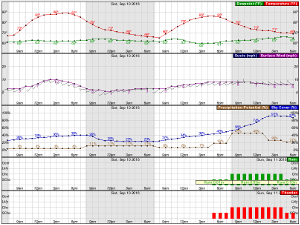 |
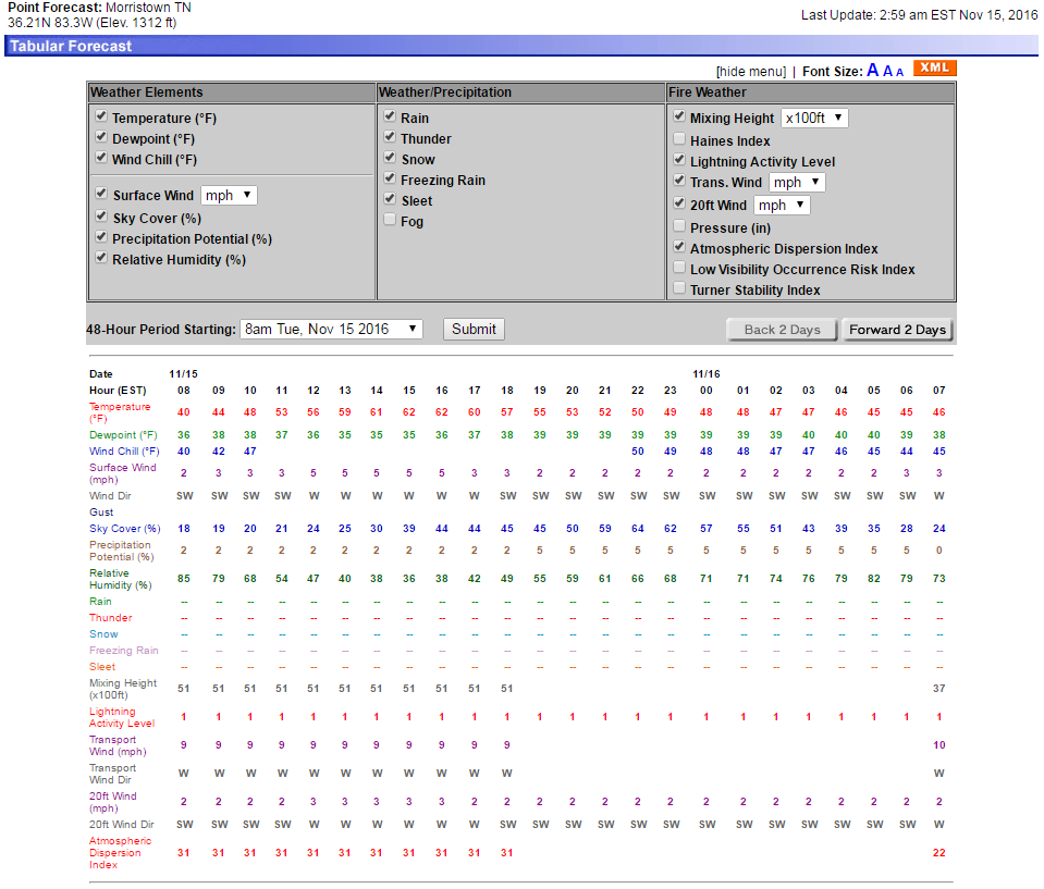 |
| Day 1 Forecast Precipitation | Day 2 Forecast Precipitation | |
 |
 |
|
| Day 3 Forecast Precipitation | Days 1-3 Forecast Precipitation | |
 |
 |
|
|
Days 6-10 |
||
| Temperature | Precipitation | |
 |
 |
|
|
Days 8-14 |
||
| TEMPERATURE | PRECIPITATION | |
 |
 |
|
| Products | ||||
| HAZARDOUS WEATHER OUTLOOK | FORECAST DISCUSSION | SPECIAL WEATHER STATEMENT | PUBLIC INFORMATION STATEMENT | |
Additional Forecasts and Outlooks
Fire Weather Outlook Issued by the Storm Prediction Center
Fire Weather Observations and Data
Local RAWS Sites Information Observed Fire Danger Rating Observed 10-hour Fuel Moisture
Current Local Observations Palmer Drought Index Map of the U.S. Observed 100-hour Fuel Moisture
Wildland Fire Assessment System Haines Index Map of the U.S. Observed 1000-hour Fuel Moisture
MADIS Meteorological Surface Observation Viewer Keetch-Byram Drought Index Map of the U.S.
Fire Weather Planning Tools Fire Weather Annual Operating Plans Weather Normals and Records
Graphical Planning Forecast Specific Point Tennessee Chattanooga
Weather Activity Planner Specific Point Virginia Knoxville
Point Forecast Matrices Specific Point North Carolina Oak Ridge


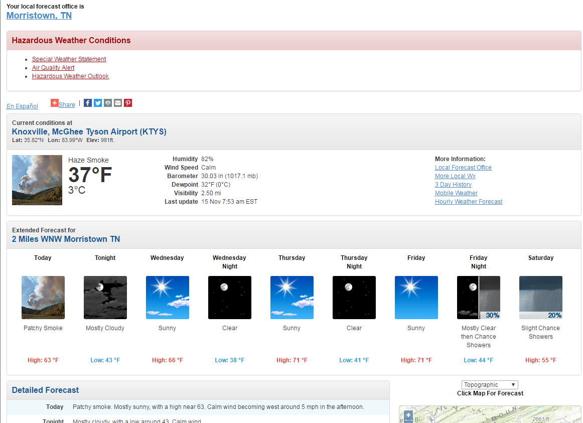
 Local Radar
 Huntsville Radar
 Regional Satellite
 Graphical Forecast
 Weather Map
 Daily Graphics
 Follow us on YouTube