An Examination of the Areal Extent of High Winds due to Mountain Waves along the Western Foothills of the Southern Appalachian Mountains
by
David M. Gaffin
ABSTRACT
- High winds associated with mountain waves have been found to occur frequently along the western foothills of the southern Appalachian Mountains from November through March. When these high wind events occurred, reports of significant wind damage were normally received from two main areas in east Tennessee: the Great Smoky Mountains National Park and the Camp Creek community of southeast Greene County. It was not known whether the National Park and the Camp Creek areas are just more reliable at reporting wind damage or actually have stronger winds compared to other areas along the western foothills. Thus, a study was conducted to examine the available observations along the western foothills of the southern Appalachian Mountains to determine the areal extent of these high winds during mountain-wave events. Due to the lack of ASOS and AWOS stations in the western foothills, eighteen WeatherBug® and three RAWS stations were examined on the 52 dates between 1999 and 2007 when mountain-wave-induced warning-level winds were reported at Cove Mountain in the National Park. Although the Cove Mountain site was at a higher elevation than most of the other sites in the western foothills, it was concluded that the higher wind speeds at Cove Mountain were mainly due to its location in the foothills of the highest ridges on the western side of the southern Appalachian Mountains. This conclusion was made because the wind speeds at Cove Mountain were found to be even stronger than those observed at the highest elevation site at Clingmans Dome.
- On the dates that Cove Mountain reported warning-level winds, it was found that only the Camp Creek site also reported at least advisory-level winds on nearly every date (87%). In addition, it was found that only the Camp Creek, Coker Creek, Shady Valley, and Erwin sites reported warning-level winds on a few of the Cove Mountain dates. The Camp Creek and Coker Creek sites reported warning-level winds on roughly a third of the dates that they were available, while the Shady Valley site reported warning-level winds on roughly a tenth of the dates that it was available. Composite maps of surface isobars, surface isotherms, and 850-mb isotachs from the warning-level wind dates revealed that the warning-level winds at Camp Creek, Coker Creek and Shady Valley resulted from a stronger low pressure system (with stronger 850-mb winds) compared to that which produced warning-level winds at Cove Mountain. Also, weaker cold-air damming on the eastern side of the southern Appalachian Mountains appeared to allow warning-level winds at the Coker Creek and Shady Valley sites, with the weakest cold-air damming observed during the warning-level wind dates at Shady Valley.
1. INTRODUCTION
- High winds due to mountain waves have been found to frequently occur from November through March within a narrow area along the western foothills of the southern Appalachian Mountains (Gaffin 2009). When these mountain wave events occur along the western foothills, reports of wind damage are normally received from two main areas in east Tennessee: the Great Smoky Mountains National Park (GSMNP) and the Camp Creek community of southeast Greene County (Figure 1). Some of the stronger wind events have produced reports of numerous large trees down in the GSMNP (which closed almost all the roads in the park), while several homes have been damaged and a few barns destroyed in the Camp Creek area. However, it was not known whether the GSMNP and the Camp Creek areas are just more reliable at reporting wind damage or actually have stronger winds compared to other areas along the western foothills of the southern Appalachian Mountains. It was previously noted in Gaffin (2009) that the location of the highest ridges in the southern Appalachian Mountain range within the GSMNP likely caused higher mountain-wave-induced winds in the GSMNP foothills. Also, it was theorized that the frequent reports of wind damage at Camp Creek were possibly the result of its location on the other side of the mountains from the French Broad Valley (where southeast winds may have accelerated up through the valley). The purposes of this study are to (1) examine the available observations in the western foothills of the southern Appalachian Mountains to determine the areal extent of the high winds during mountain-wave events and (2) examine the synoptic conditions which produced warning-level winds at the different sites.
2. DATA AND METHODOLOGY
- The National Park Service Air Resources Division maintains a network of wind observations within the GSMNP (Figure 2), including sites at Cove Mountain (elevation of 1,265 m or 4,150 ft MSL), Cades Cove (564 m or 1,850 ft MSL), Look Rock (823 m or 2,700 ft MSL), and Clingmans Dome (2,033 m or 6,670 ft MSL). These anemometers record hourly-averaged sustained winds. Since the Cove Mountain observation in the GSMNP normally reports the highest winds during mountain-wave events, Gaffin (2009) conducted a mountain-wave-induced high wind climatology of the Cove Mountain site. High wind warnings are issued by the National Weather Service when sustained winds of at least 18 m s-1 (40 mph) occur for an hour or longer, or wind gusts of at least 26 m s-1 (58 mph) occur. Thus, the Gaffin (2009) climatology found those dates when southeasterly (direction between 90 and 1800) sustained winds of at least 18 m s-1 (40 mph) occurred at Cove Mountain along with an observed stable boundary layer and a veering wind profile observed on the Atlanta sounding. This methodology likely gave a good estimate of how many warning-level wind events at Cove Mountain resulted from mountain waves, since it covered many of the necessary ingredients for mountain wave formation including a strong southeasterly wind (perpendicular to the mountain ridges), an upstream stable boundary layer extending above the mountain tops, and a veering wind profile (which eventually produced a critical layer).
- Because Automated Surface Observation System (ASOS) and Automated Weather Observing System (AWOS) sites are non-existent in the western foothills of the southern Appalachian Mountains, eighteen WeatherBug sites near the western foothills of the southern Appalachian Mountains were examined for high winds (Figure 3; Table 1). All of the WeatherBug sites in this study were located on the roofs of schools, with the exception of Holston Mountain which was located on a television transmission tower. WeatherBug anemometers are fairly similar to ASOS and AWOS sites in that they report two-minute-averaged sustained winds with one-second wind gusts. In addition to the WeatherBug sites, three Remote Automated Weather Stations (RAWS) sites (maintained by the U.S. Forest Service) that were located near the western foothills of the southern Appalachian Mountains were examined: Coker Creek (CCKT1), Indian Grave (IGGT1), and Unicoi (PGVT1). RAWS anemometers are located on a 20 foot tower with ten-minute-averaged sustained winds and five-second-averaged wind gusts. Thus, RAWS winds are expected to be slower than WeatherBug winds. Although many of the WeatherBug and RAWS sites were not always available on the dates that high winds were reported at Cove Mountain, the available sites were examined to determine if sustained winds were at least 18 m s-1 (40 mph) or wind gusts were above 26 m s-1 (58 mph). In addition to searching for warning-level winds, the occurrence of advisory-level winds, which are defined in this study as sustained winds of at least 11 m s-1 (25 mph), was noted as well. The other three sites in the GSMNP (Clingmans Dome, Look Rock, and Cades Cove) were not evaluated in this study, since wind gust data were not available at these three sites. In addition, the Clingmans Dome observation was only available on a seasonal basis (from May through October).
- After the WeatherBug and RAWS stations were evaluated for high winds on the same dates that produced mountain-wave-induced high winds at Cove Mountain, composite maps of surface isobars, surface isotherms, and 850-hPa isotachs were constructed from the dates that warning-level winds were observed at the different sites. These composite maps were constructed from the National Centers for Environmental Prediction-National Center for Atmospheric Research reanalysis dataset (Kalnay et al. 1996) on the National Oceanic and Atmospheric Administration-Cooperative Institute for Research in Environmental Sciences Climate Diagnostics Center's Web site.
3. RESULTS
- Of the 52 dates when mountain-wave-induced warning-level winds were reported at Cove Mountain between 1999 and 2007, there were only five sites (Erwin, Camp Creek, Holston Mountain, Shady Valley, and Coker Creek) that reported advisory-level winds or stronger during at least a third of the time that they were available (Table 2). It was found that only the Camp Creek site reported at least advisory-level winds on nearly every date (87%) that warning-level winds were observed at Cove Mountain. In addition, it was found that only the Camp Creek, Coker Creek, Shady Valley, and Erwin sites reported warning-level winds on a few of the Cove Mountain dates. The Camp Creek and Coker Creek sites reported warning-level winds on roughly a third of the dates that they were available, while the Shady Valley site reported warning-level winds on roughly a tenth of the dates that it was available. While the Holston Mountain site reported advisory-level winds on 60% of the dates that it was available, this finding was likely the result of its higher elevation compared to the other sites. The Cove Mountain site was also around the same elevation as Holston Mountain, but the higher wind speeds at Cove Mountain were likely due to its location in the foothills of the highest ridges on the western side of the southern Appalachian Mountains. A comparison of Cove Mountain to Clingmans Dome (which was 768 m or 2519 ft higher in elevation) on the available dates (5 May 2003, 22 September 2003, 23 September 2006, 17 October 2006, and 27 October 2006) revealed that Clingmans Dome reported weaker sustained winds on all five of these dates. In fact, the sustained winds at Clingmans Dome during four of the events were generally 7 to 9 m s-1 (15 to 20 mph) less than Cove Mountain, except on 17 October 2006 when the sustained winds were only 1 to 2 m s-1 (2 to 5 mph) less.
- Composite maps of surface isobars, surface isotherms, and 850-hPa isotachs from the warning-level wind dates revealed that warning-level winds at Camp Creek were the result of a stronger low pressure system (with stronger 850-hPa winds) compared to that which produced warning-level winds at Cove Mountain (Figure 4). Also, a low pressure system with 850-hPa winds of similar intensity to the Camp Creek composite was observed in both the Coker Creek and Shady Valley composites (Figure 5). A cold-air damming scenario (Bell and Bosart 1988) was observed on the eastern side of the southern Appalachian Mountains in all four composites of surface isotherms. While the cold-air damming in the Cove Mountain and Camp Creek composites was of a similar intensity, weaker cold-air damming was observed in the Coker Creek and Shady Valley composites with the weakest cold-air damming in the Shady Valley composite.
4. CONCLUSIONS
- From the available WeatherBug and RAWS sites in the western foothills of the southern Appalachian Mountains, it was found that the Cove Mountain and Camp Creek observation sites reported the fastest winds of all the available data. It's possible that the Camp Creek site may have experienced even higher winds than what was reported, since a visit to this site found that there was some potential blockage (in the form of a higher gymnasium roof) to the southeast of the anemometer. The fact that Cove Mountain had the highest wind speeds of any reporting site along the western foothills was likely the result of its location near the highest ridges of the western side of the southern Appalachian Mountains. This conclusion was made because the wind speeds at Cove Mountain were found to be even stronger than those observed at Clingmans Dome (which was 768 m or 2519 ft higher than Cove Mountain) during the five available events. Because mountain waves normally produce high winds in a narrow area along the foothills, it's still possible that some of the sites examined in this study were not at the proper location to directly measure mountain-wave-induced high winds in their immediate vicinities. Thus, high winds due to mountain waves may be more extensive (and of stronger intensities) along the western foothills of the southern Appalachian Mountains than can be determined in this study. However, this study should be considered a first step in confirming that the GSMNP and Camp Creek areas are not just reliable damage-reporting sites, but also experience some of the strongest winds during mountain-wave events along the western foothills of the southern Appalachian Mountains.
- After examining composites of surface isobars, surface isotherms, and 850-hPa isotachs, it was found that the warning-level winds at Camp Creek, Coker Creek and Shady Valley resulted from a stronger low pressure system (with stronger 850-hPa winds) compared to that which produced warning-level winds at Cove Mountain. Cold-air damming was observed on the eastern side of the southern Appalachian Mountains in all four composites of surface isotherms, but weaker cold-air damming was observed in the Coker Creek and Shady Valley composites. This weaker cold-air damming likely allowed warning-level winds to develop at these sites due to less blockage of the low-level southeasterly winds. The weakest cold-air damming was observed in the Shady Valley composite, which was likely necessary to allow strong low-level southeasterly winds to penetrate further north into northeast Tennessee. It's possible that warning-level winds were still able to occur at Cove Mountain and Camp Creek despite the stronger cold-air damming, since mountain ridges with higher elevations were located near these two sites. Thus, strong southeasterly winds at a slightly higher elevation (over-riding the cold air at the surface) could still produce mountain waves at these two sites, while not producing mountain waves at Coker Creek or Shady Valley (where the mountain ridges are not as high which would require strong southeasterly winds at a lower elevation). Since the Camp Creek composites can not fully resolve the question of whether the observed cold-air damming blocked southeasterly winds in the French Broad Valley, additional future research with high-resolution computer models should be conducted to determine if the frequent reports of wind damage at Camp Creek were possibly the result of its location on the other side of the mountains from the French Broad Valley (where southeast winds may have accelerated up through the valley).
5. ACKNOWLEDGMENTS
- The author would like to thank Tim Hyatt, Terry Hambrick, and Bill Callahan of AWS Convergence Technologies for the WeatherBug data. Also, thanks to Jim Renfro of the Great Smoky Mountains National Park and Jessica Ward of Air Resource Specialists, Inc. for their help in retrieving the Cove Mountain wind data.
6. REFERENCES
- Bell, G. D., and L. F. Bosart, 1988: Appalachian Cold-Air Damming. Mon. Wea. Rev., 116, 137-161.
- Gaffin, D. M., 2009: On High Winds and Foehn Warming associated with Mountain Wave Events in the Western Foothills of the Southern Appalachian Mountains. Wea. Forecasting, 24, 53-75.
- Kalnay, E., and Coauthors, 1996: The NCEP/NCAR Reanalysis 40-Year Project. Bull. Amer. Meteor. Soc., 77, 437-471.
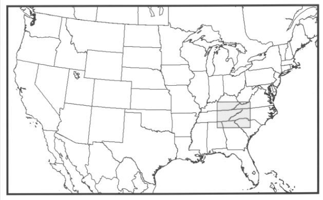
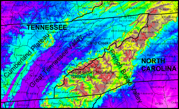
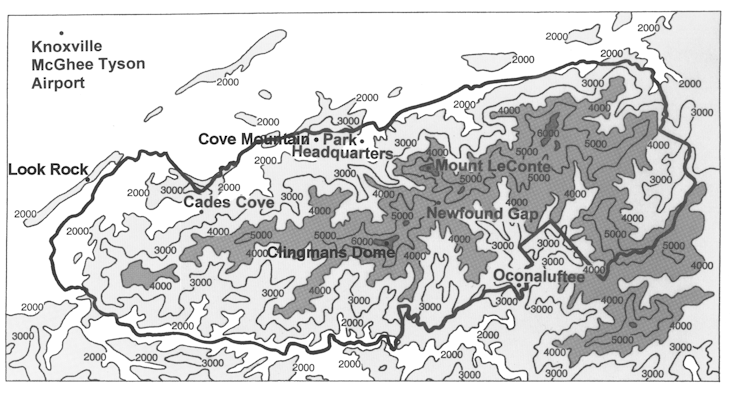
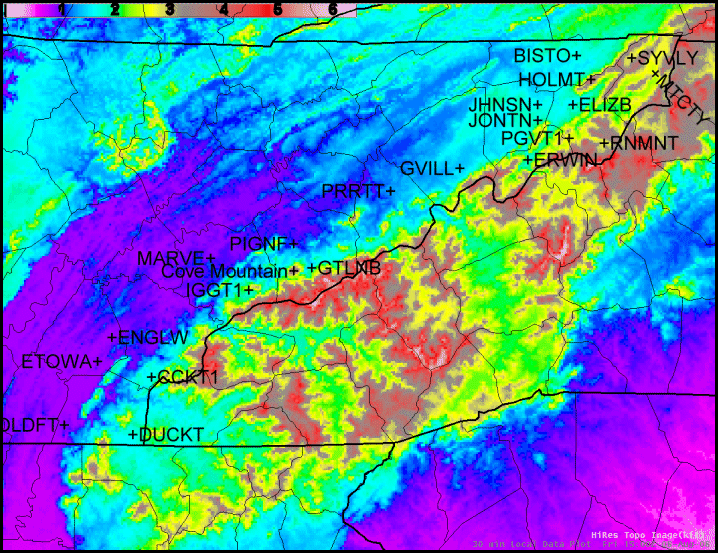
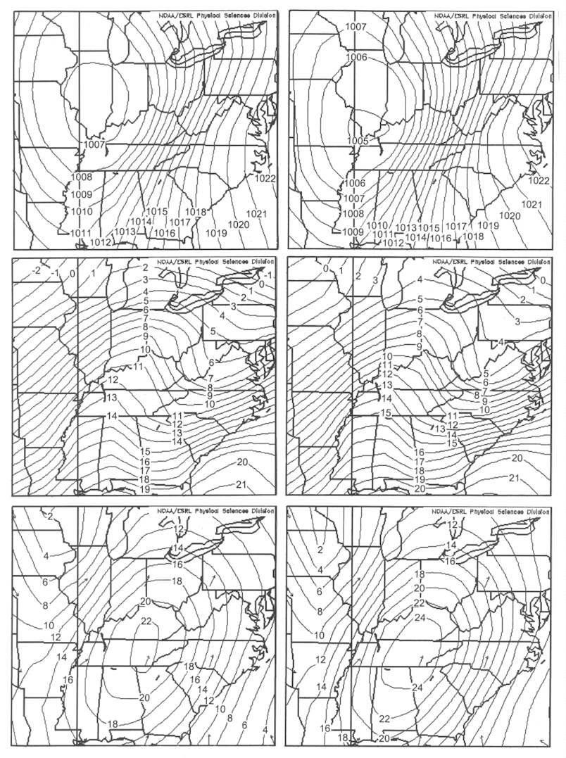
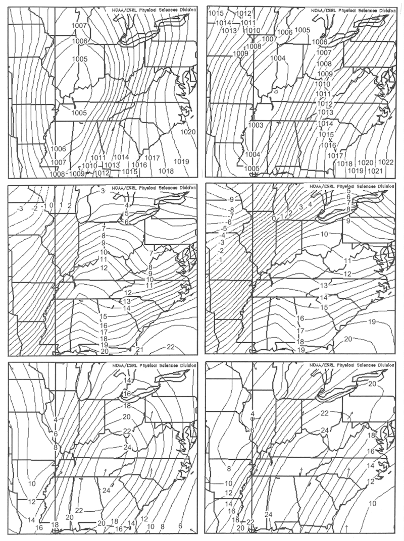
Table 1. WeatherBug and RAWS sites along the western foothills of the southern Appalachian Mountains.
| Stations |
Elevation (MSL) |
| Bristol (BISTO) |
498 m (1634 ft) |
| Coker Creek (CCKT1) |
518 m (1700 ft) |
| Ducktown (DUCKT) |
527 m (1729 ft) |
| Elizabethton (ELIZB) |
496 m (1627 ft) |
| Englewood (ENGLW) |
260 m (853 ft) |
| Erwin (ERWIN) |
566 m (1857 ft) |
| Etowah (ETOWA) |
271 m (889 ft) |
| Gatlinburg (GTLNB) |
448 m (1470 ft) |
| Camp Creek (GVILL) |
435 m (1427 ft) |
| Holston Mountain (HOLMT) |
1284 m (4213 ft) |
| Indian Grave (IGGT1) |
823 m (2700 ft) |
| Johnson City (JHNSN) |
503 m (1650 ft) |
| Johnson City (JONTN) |
563 m (1847 ft) |
| Maryville (MARVE) |
313 m (1027 ft) |
| Mountain City (MTCTY) |
768 m (2520 ft) |
| Old Fort (OLDFT) |
276 m (906 ft) |
| Pigeon Forge (PIGNF) |
305 m (1001 ft) |
| Parrottsville (PRRTT) |
371 m (1217 ft) |
| Roan Mountain (RNMNT) |
844 m (2769 ft) |
| Shady Valley (SYVLY) |
860 m (2822 ft) |
| Unicoi (PGVT1) |
732 m (2400 ft) |
|
Table 2. A comparison of the available observation sites along the western foothills on the warning-level wind dates at Cove Mountain (x indicates availability but no high winds observed, A indicates advisory-level winds observed, W indicates warning-level winds observed)
| Dates of high winds at Cove Mountain |
B
I
S
T
O |
D
U
C
K
T |
E
L
I
Z
B |
E
N
G
L
W |
E
R
W
I
N |
E
T
O
W
A |
G
T
L
N
B |
G
V
I
L
L |
H
O
L
M
T |
J
H
N
S
N |
J
O
N
T
N |
M
A
R
V
E |
M
T
C
T
Y |
O
L
D
F
T |
P
I
G
N
F |
P
R
R
T
T |
R
N
M
N
T |
S
Y
V
L
Y |
C
C
K
T
1 |
I
G
G
T
1 |
P
G
V
T
1 |
| 1/2/99 |
x |
|
|
|
|
x |
x |
|
|
x |
|
x |
x |
x |
|
|
|
x |
|
|
|
| 1/22/99 |
x |
|
|
|
|
x |
x |
|
|
x |
|
x |
x |
x |
|
|
|
x |
|
|
|
| 1/31/99 |
x |
|
|
|
|
x |
x |
|
|
x |
|
x |
x |
x |
|
|
|
|
|
|
|
| 3/6/99 |
x |
|
|
|
|
x |
x |
|
|
x |
|
x |
x |
x |
|
|
|
|
|
|
|
| 3/9/99 |
x |
|
|
|
|
x |
x |
|
|
x |
|
x |
x |
x |
|
|
|
|
|
|
|
| 12/10/99 |
x |
|
|
|
|
x |
|
|
|
x |
|
x |
x |
|
|
|
|
x |
|
|
|
| 1/4/00 |
x |
|
|
|
|
x |
|
|
|
A |
|
|
x |
|
|
|
|
A |
|
|
|
| 3/20/00 |
x |
|
|
|
|
x |
|
|
|
x |
|
|
|
|
|
|
|
|
|
|
|
| 12/17/00 |
|
|
|
|
|
|
x |
|
|
|
|
|
|
|
|
|
|
|
|
|
|
| 1/30/01 |
|
|
|
|
|
|
x |
A |
|
x |
|
A |
x |
|
|
|
|
x |
|
|
|
| 2/25/01 |
|
|
|
|
|
|
x |
A |
|
x |
|
x |
x |
|
|
|
|
A |
|
|
|
| 3/12/01 |
x |
|
|
|
x |
x |
x |
A |
|
|
|
x |
x |
|
|
|
|
x |
|
|
|
| 11/25/01 |
x |
x |
x |
x |
x |
x |
|
A |
|
|
|
|
x |
|
|
x |
|
A |
|
|
|
| 12/14/01 |
x |
x |
x |
A |
x |
x |
|
A |
|
|
|
|
x |
|
|
x |
|
x |
|
|
|
| 12/17/01 |
x |
x |
x |
x |
x |
x |
|
W |
|
|
|
|
x |
|
|
x |
|
x |
|
|
|
| 12/23/01 |
x |
x |
x |
x |
|
x |
|
W |
|
|
|
|
x |
|
|
x |
|
A |
|
|
|
| 2/1/02 |
x |
x |
x |
x |
A |
x |
|
A |
|
|
|
|
x |
|
x |
x |
x |
x |
|
|
|
| 2/20/02 |
x |
|
x |
x |
A |
x |
|
A |
|
A |
x |
|
x |
|
x |
x |
x |
A |
|
|
|
| 4/8/02 |
|
A |
x |
x |
x |
A |
x |
W |
|
x |
x |
|
x |
|
x |
x |
|
A |
|
|
|
| 11/5/02 |
|
x |
x |
|
x |
x |
x |
W |
|
x |
x |
|
x |
|
x |
x |
x |
x |
x |
x |
x |
| 11/10/02 |
|
x |
x |
|
x |
x |
x |
A |
|
x |
x |
|
x |
|
x |
x |
x |
A |
x |
x |
x |
| 12/19/02 |
|
x |
x |
|
A |
x |
x |
W |
|
x |
x |
|
x |
|
x |
x |
x |
A |
A |
x |
x |
| 12/24/02 |
|
x |
x |
|
x |
x |
x |
x |
|
x |
x |
|
x |
|
|
x |
x |
x |
x |
x |
x |
| 3/19/03 |
x |
x |
x |
|
x |
x |
|
A |
|
x |
x |
|
x |
|
|
x |
x |
A |
A |
x |
x |
| 5/5/03 |
x |
x |
x |
|
|
x |
x |
W |
|
x |
|
|
x |
|
x |
|
x |
x |
x |
x |
x |
| 9/22/03 |
x |
|
x |
|
x |
x |
|
A |
|
x |
|
|
x |
|
|
x |
x |
x |
x |
x |
x |
| 11/18/03 |
x |
|
|
|
x |
x |
|
W |
|
x |
|
|
x |
|
|
x |
x |
A |
W |
x |
x |
| 11/24/03 |
x |
|
|
x |
x |
x |
|
A |
|
x |
|
|
x |
|
|
x |
x |
A |
A |
x |
x |
| 12/30/03 |
x |
|
x |
|
x |
x |
|
A |
|
x |
|
|
x |
|
|
|
x |
A |
A |
x |
x |
| 1/25/04 |
x |
|
x |
|
x |
x |
|
W |
|
x |
|
|
x |
|
|
x |
x |
x |
x |
|
|
| 2/6/04 |
x |
|
A |
|
A |
x |
|
W |
|
x |
|
|
x |
|
|
x |
x |
A |
|
|
|
| 3/2/04 |
x |
|
x |
|
x |
x |
|
A |
|
|
|
|
x |
|
|
x |
x |
x |
x |
x |
x |
| 12/1/04 |
x |
|
x |
x |
|
x |
|
x |
A |
x |
|
|
x |
|
|
x |
x |
A |
W |
x |
x |
| 12/23/04 |
x |
|
A |
x |
A |
x |
|
|
A |
x |
|
|
A |
|
|
A |
|
W |
W |
x |
x |
| 1/13/05 |
x |
|
|
x |
W |
x |
|
|
x |
x |
|
|
x |
|
|
x |
x |
W |
A |
x |
x |
| 2/14/05 |
x |
|
x |
|
x |
x |
|
|
x |
x |
|
|
x |
|
|
x |
x |
x |
x |
x |
x |
| 11/28/05 |
x |
|
x |
x |
x |
x |
|
A |
A |
x |
|
|
x |
|
|
x |
x |
A |
A |
x |
x |
| 12/9/05 |
x |
|
x |
x |
x |
x |
|
A |
A |
x |
|
|
x |
|
|
x |
x |
A |
x |
x |
x |
| 1/17/06 |
x |
|
x |
x |
x |
x |
|
A |
A |
x |
|
|
x |
|
|
x |
x |
A |
W |
x |
x |
| 1/29/06 |
A |
|
x |
x |
A |
x |
|
A |
x |
x |
|
|
x |
|
|
x |
x |
x |
|
x |
x |
| 2/2/06 |
x |
|
x |
x |
A |
x |
|
A |
A |
x |
|
|
x |
|
|
x |
x |
A |
|
x |
x |
| 3/10/06 |
x |
|
x |
x |
A |
x |
|
A |
x |
x |
|
|
x |
|
|
x |
x |
W |
|
|
|
| 9/23/06 |
x |
|
x |
x |
x |
x |
|
x |
x |
x |
|
|
x |
|
|
x |
x |
x |
x |
x |
x |
| 10/17/06 |
x |
|
x |
x |
x |
x |
|
W |
A |
x |
|
|
x |
|
|
x |
x |
A |
W |
x |
x |
| 10/27/06 |
x |
|
x |
x |
x |
x |
|
|
A |
x |
|
|
x |
|
|
x |
x |
A |
x |
x |
x |
| 11/16/06 |
x |
|
|
x |
x |
x |
|
W |
x |
x |
|
|
x |
|
|
x |
x |
A |
W |
x |
x |
| 12/13/06 |
x |
|
|
x |
x |
x |
|
x |
x |
x |
|
|
x |
|
|
x |
x |
x |
x |
x |
x |
| 1/7/07 |
x |
|
|
x |
A |
x |
|
x |
A |
x |
|
|
x |
|
|
x |
x |
x |
|
x |
x |
| 2/25/07 |
x |
|
|
|
x |
x |
|
W |
A |
x |
|
|
x |
|
|
x |
x |
x |
|
x |
x |
| 3/1/07 |
x |
|
|
|
A |
x |
|
A |
A |
x |
|
|
x |
|
|
x |
x |
A |
|
x |
x |
| 4/11/07 |
x |
|
|
|
x |
x |
|
A |
A |
x |
x |
|
x |
|
|
x |
x |
A |
A |
x |
x |
| 12/23/07 |
x |
|
x |
|
|
x |
|
W |
x |
x |
x |
|
x |
|
|
A |
x |
A |
W |
x |
x |
| TOTAL |
44 |
12 |
31 |
23 |
37 |
49 |
15 |
39 |
20 |
44 |
9 |
9 |
50 |
5 |
7 |
38 |
34 |
46 |
26 |
30 |
30 |
| Advisory # |
1 |
1 |
2 |
1 |
10 |
1 |
0 |
21 |
12 |
2 |
0 |
1 |
1 |
0 |
0 |
2 |
0 |
24 |
7 |
0 |
0 |
| % of total |
2 |
8 |
6 |
4 |
27 |
2 |
0 |
54 |
60 |
5 |
0 |
11 |
2 |
0 |
0 |
5 |
0 |
52 |
27 |
0 |
0 |
| Warning # |
0 |
0 |
0 |
0 |
1 |
0 |
0 |
13 |
0 |
0 |
0 |
0 |
0 |
0 |
0 |
0 |
0 |
3 |
7 |
0 |
0 |
| % of total |
0 |
0 |
0 |
0 |
3 |
0 |
0 |
33 |
0 |
0 |
0 |
0 |
0 |
0 |
0 |
0 |
0 |
7 |
27 |
0 |
0 |
|


 Local Radar
 Huntsville Radar
 Regional Satellite
 Graphical Forecast
 Weather Map
 Daily Graphics
 Follow us on YouTube