|
|||||
| Hurricane Frances formed from a tropical depression in the deep tropical Atlantic on August 25 about 1400 miles east of the Lesser Antilles and reached hurricane strength on August 26. Frances became a Category 4 Hurricane on August 28 while about 700 miles east of the Lesser Antilles. Frances then moved generally west northwest and weakened to a Category 2 hurricane while crossing the northwest Bahamas. After stalling for about 12 hours on September 4 in the Florida Straits between Grand Bahama Island and the southeast Florida coast, the center of the nearly 70-mile diameter eye crossed the Florida coast near Sewalls Point, at 1 A.M. EDT, September 5, 2004 with the southern eyewall affecting the extreme northeast portion of Palm Beach County. Frances moved farther inland just north of Lake Okeechobee and weakened to a tropical storm before crossing the entire Florida Peninsula and exiting into the Gulf of Mexico just north of Tampa late on September 5. It made a second landfall as a tropical storm in the eastern Florida Panhandle. Sustained tropical storm-force winds likely occurred in all six south Florida counties. Although no sustained hurricane-force winds were officially observed in any of the six south Florida counties, an NWS instrument on the eastern shore of Lake Okeechobee at Port Mayaca, just across the Palm Beach County border, measured a sustained wind of 85 mph. At West Palm Beach International Airport the highest sustained wind was 64 mph with a peak gust of 82 mph and the lowest observed barometric pressure was 972 mb. A South Florida Water Management District instrument measured a peak wind gust of 92 mph over the eastern portion of Lake Okeechobee. The estimated peak wind gust in the Palm Beach metro area was 91 mph at Jupiter Inlet with a peak wind gust of 87 mph measured by a C-MAN station at Lake Worth Pier. In Glades County near the western shore of Lake Okeechobee the highest measured sustained wind was 60 mph with a peak gust of 90 mph. In Clewiston, a sustained wind of 60 mph with a gust of 80 mph was estimated. The highest measured sustained wind at Fort Lauderdale-Hollywood International Airport was 41 mph with a peak gust of 55 mph. In Miami-Dade County a maximum sustained wind of 62 mph with a peak gust of 78 mph was measured at the C-MAN station at Fowey Rocks Light with sustained winds of 42 mph and a peak gust of 59 mph at Miami International Airport. At the Naples Municipal Airport the ASOS measured a maximum sustained wind of 38 mph with a peak gust of 54 mph. A maximum storm-total rainfall amount of 13.56 inches was measured at West Palm Beach International Airport with 10.36 inches of that occurring in a 24-hour period. Unofficial storm-total rainfalls included 9.56 inches at Boynton Beach, 8 inches at Deerfield Beach and 7.18 inches at Hillsboro Canal. Widespread storm-total amounts of 3 to 5 inches occurred in southeast and interior south Florida with southwest Florida averaging 1 to 3 inches. Rainfall flooding was mostly minor except for a few locations in Palm Beach County which had up to 3 feet of standing water. A section of I-95 in Palm Beach County was closed due to a large sinkhole. The maximum storm surge was estimated to have ranged from 2 to 4 feet along the northeast Palm Beach Coast to 1 to 2 feet along the northeast Broward Coast. Within the confines of the Herbert Hoover Dike, water levels on Lake Okeechobee fluctuated up to 5 feet above and below normal. Coastal beach erosion was moderate in Palm Beach and portions of Broward counties and was minor in Miami-Dade and Collier counties. There were no confirmed tornadoes in South Florida. There were no known direct deaths, but at least 9 people died in the aftermath. Six of these deaths occurred in Palm Beach County, mainly as the result of vehicle-related accidents or from drownings. Two vehicle-related deaths were reported in Broward County and one person died in Collier County while clearing debris. An unknown number of injuries occurred. Property damage at the coast occurred mainly to marinas, piers, seawalls, bridges and docks, as well as to boats. Inland structure damage included 15,000 houses and 2,400 businesses in Palm Beach County. Wind damage to house roofs, mobile homes, trees, power lines, signs, screened enclosures and outbuildings occurred over much of southeast Florida including areas near Lake Okeechobee, but was greatest in Palm Beach County. A preliminary damage estimate for Frances in south Florida is $620 million, including $500 million in Palm Beach, $80 million in Broward, and $34 million in Miami-Dade. Crop damage in Palm Beach County was estimated at an additional $70 million to sugar cane and vegetables and additional heavy losses occurred to nurseries. Florida Power and Light reported power outages occurred to 659,000 customer in Palm Beach, 590,000 in Broward, 423,000 in Miami-Dade, 39,200 in Collier, 2,500 in Hendry and 1,700 in Collier. An estimated 17,000 persons sought refuge in public shelters in Palm Beach County and nearly 7,000 in Broward County. |
 Wind swath analysis from Hurricane Frances. (from NOAA/AOML)  Preliminary track showing the center of Hurricane Frances as it moved across the Florida Peninsula 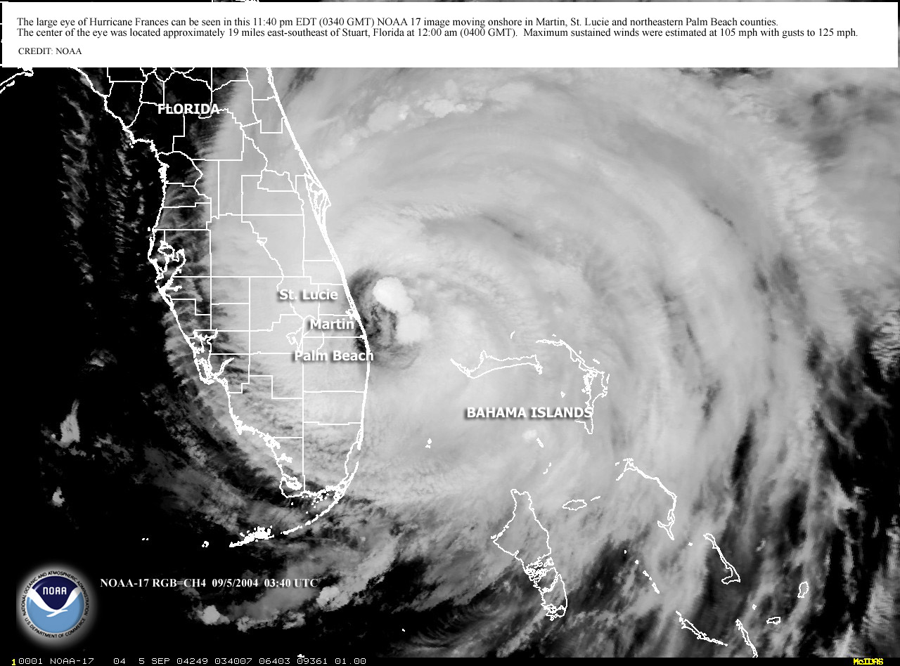 Satellite image from 4 September 2004 at 11:40 pm. The center was located approximately 19 miles east-southeast of Stuart, Florida.  NWS Miami radar animation from Sept 4th and 5th. Click on image for longer animation. (caution: file is large)  Water level readings from the U.S Army Corps of Engineers sites on Lake Okeechobee. Water level readings from the U.S Army Corps of Engineers sites on Lake Okeechobee. |
||||
Additional Information National Hurricane Center report on Hurricane Frances AOML Wind Swath Analyses National Hurricane Center report on Hurricane Frances AOML Wind Swath Analyses |
|||||


 Follow us on YouTube