|
Hurricane Donna, the first major hurricane in Florida since the Miami storm of October 1950, was first detected in the tropical North Atlantic on September 2. Donna then travelled for some 2000 miles mostly in a west-northwest direction through the extreme north-eastern Antilles, passing some 70 miles north of Puerto Rico, info the Florida Straits. The center of the hurricane crossed over the middle Florida Keys between 2 and 3 a.m. on the 10th. After keeping a short distance off shore, it reached the coastline again south of Naples and then turned north and northeastward, passing out to sea a short distance north of Daytona Beach. Donna was one of the most destructive hurricanes to affect Florida in modern times. There were 12 fatalities in Florida, attributable either directly or indirectly to the storm. There were 6 deaths by drowning, 4 from heart attacks, 1 in an automobile accident and 1 electrocution. At the time this publication goes to print, it is impracticable to indicate a realistic estimate of the total storm damage. Various authorities have made estimates that range from approximately $36 million to $350 million (in 1960 dollars). In most localities subject to tidal inundation, evacuation either to the area outside or to designated places of refuge was 90 to 95 percent. Thus the loss of life per unit damage was the least of any major hurricane ever affecting Florida.
Storm damages ranged from very severe on the middle Keys and on the southwest coast from Everglades City to Punta Gorda to relatively minor at northeast Florida points north of the storm track. Damage and rainfall, in general, were significantly greater and noticeable farther from the center on the right side of the track than on the left. Damages by wind and tide on the Keys ranged from almost complete destruction of all but the most substantial buildings in the Marathon-Tavernier area to loss of roofs, broken windows, water damages and battered boats and dock facilities at other points throughout the Keys. The Overseas Highway was overflowed by the storm tides at a number of places, and the road completely disappeared at bridge approaches at several points. The pipeline supplying the Keys with fresh water was broken in at least five places requiring water to be brought in by truck or boat. Tides at Tavernier were reported to be about eighteen inches lower than those associated with the famous Labor Day 1935 storm on the Keys. Preliminary surveys indicated that at certain points, tides probably reached at least 12 feet above mean low water. Tides in the Everglades City-Naples-Ft. Myers Beach area were estimated 4 to 7 feet above normal and perhaps even higher in some places. At Naples, tides pushed inland to the center of the city damaging buildings and smashing docks all along the intrusion. Everglades City, a town that had been largely evacuated, was also inundated by tides and about 50% of the buildings in that city were destroyed by tides and winds. Tides farther north were progressively lower as the winds in advance of the storm center were offshore on the Gulf coast and the center itself was travelling over land. On the gulf coast north of Bradenton and on the Atlantic coast north of the Palm Beaches, tides were mostly 1 to 3 feet above normal and tide damage was relatively minor. Tides in the Miami-Miami Beach ran mostly 2 to 4 feet above normal and tidal flooding in this area was not a major contributor to the over-all damage.
At Sombrero Light, which was west of the area of strongest winds, the highest 1-minute wind velocity was 106 mph with gusts to 150. At Tavernier, the fastest recorded mile was 120 mph which was the highest point on the dial. The anemometer needle held solid against the 120 mph pin for 45 minutes. Tavernier also was a little outside the area of the strongest winds. The maximum sustained winds were estimated around 140 mph with possible momentary gusts of 175 to 180 mph on the Florida Keys. The Ft. Myers maximum sustained wind was 92 mph with gusts to 121. Sustained winds in excess of 100 mph with gusts possibly to 140-150 mph quite probably occurred at Naples and Everglades City. Gusts to 100 mph were measured as far north as Sarasota. In the greater Miami area, sustained winds of just about hurricane force were recorded briefly with momentary gusts at the Weather Bureau Office to 82 mph and the airport tower to 97 mph.
Wind damage was enormous on the Keys and on the southwest coast from Everglades City to Punta Gorda. Even well outside these areas, the wind toppled thousands of trees, demolished many weaker buildings, blew off or damaged roofs, and shattered many windows. Wind driven rain added materially to the over-all storm damage throughout the area. Power and communications facilities fell throughout central and south Florida. A large part of the central peninsula citrus belt was subjected to the strong right side of the storm. Gusty winds uprooted or blew over trees on ridges and other unprotected locations, stripped the leaves off trees and blew fruit off many trees. Preliminary estimates by the U.S. Department of Agriculture indicated grapefruit losses between 25 and 35% of the state's crop, and probably 5 to 10% of the state's orange and tangerine crops were lost. The avocado crop was hit hard; most of the fruit was blown from the trees and the trees themselves sustained heavy damage.
Reported heavy rainfall during this storm ranged from 5 to 10 inches in an 80 to 100 mile wide belt extending roughly 50 to 75 miles to the right of the storm track and 30 to 40 miles to the left of the track. Heaviest rains apparently fell on the extreme southern peninsula; reported totals in the Miami and south Dade County area were mostly 7 to 10 inches with a few totals near 12 inches. Rainfall data for stations south of Ft. Myers were apparently lost when gages were either blown away or tipped over. North of Ft. Myers, reported storm totals were mostly 5 to 7 inches with the greatest amounts reported in the central and southern sections of the area. The rainfall flood potential of this storm was augmented by antecedent rains. Rainfall during the three weeks prior to Donna totaled 6 to 10 inches over the affected areas, hence water tables and lake levels were relatively high just before the storm. Lake and stream overflow, especially in the central peninsula, forced evacuation of some homes. High waters also closed many roads and inundated considerable agricultural lands throughout the storm affected areas. from Climatological Data 1960
For a detailed summary of Donna, please click here for a slide presentation prepared by Rusty Pfost, former WFO Miami Meteorologist-in-Charge.
|
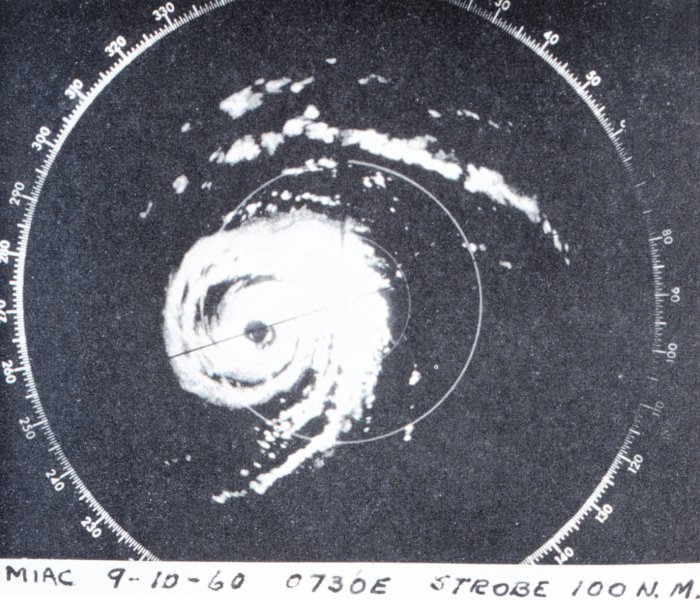
Radar image of Hurricane Donna on its closest approach to Miami illustrating all the features of a classic hurricane.

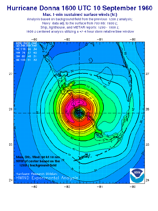
Wind analysis of Hurricane Donna from at UTC, 10 Sept. (from NOAA/AOML)

Flooding caused by Hurricane Donna. Looking south from Biscayne Boulevard in Miami.
|
 Wind Analyses (from NOAA/AOML/HRD)

 Follow us on YouTube