|
|||||||||||||
 Synopsis and Description of Tornadoes Several ingredients came together for an outbreak of supercell thunderstorms across South Florida from the evening of Tuesday, February 12 through the early morning of Wednesday, February 13. An upper-level storm system moving across Central Florida combined with a warm front moving northward over South Florida provided the wind shear necessary for the formation of supercell thunderstorms and tornadoes. As the warm front moved northward over the region, low-level moisture and instability increased, providing a favorable combination of ingredients for an outbreak of tornadoes. The 13/00Z RAOB from KMFL indicated 1100 J/kg of CAPE and approximately 300 m2/s2 of 0-3 km storm relative helicity. A total of 13 tornado warnings were issued Tuesday night across South Florida with two of them confirmed. The rest of the tornado warnings involved storms that moved across sparsely populated areas with no confirmations received.
The first confirmed tornado of the evening occurred in Everglades City, FL, which is located along the Gulf Coast side of the peninsula in southwestern Collier County. This tornado initially touched down at the Everglades Airport around 10 PM, where two Cesna aircrafts were flipped upside down and destroyed. The tornado then traveled north-northeastward approximately 1.25 miles, and was responsible for producing several reports of downed trees and roof damage throughout Everglades City (including the City School) and damage to several boats at the Everglades City Marina. The timing of the reports ranged from around 10 PM to 1015 PM. This tornado was spawned ahead of a supercell thunderstorm over the near shore Gulf of Mexico waters to the west of Mainland Monroe County, and moved northeastward crossing the shore line south of Everglades City around 1015 PM. The Everglades City tornado was rated an EF0 on the Enhanced Fujita Scale, with maximum wind speeds of 85 mph. WFO Miami issued a Tornado Warning at 1006 PM for the mesocyclone that was offshore and crossed the shore line south of Everglades City. Everglades City Tornado (Collier County)
The second confirmed tornado of the evening occurred in the highly- populated Riverland neighborhood of Fort Lauderdale, FL. This tornado initially touched down just north of Interstate 595 (Port Everglades Expressway) near the intersection of Interstate 595 and SW 31st Avenue. The tornado then traveled north-northeastward roughly along SW 31st Avenue for approximately 2.5 to 3 miles, before lifting just south of Sunrise Boulevard. The tornado was approximately one eighth of a mile wide at it's widest point in the region between SW 4th Street and SW 8th Street, or between Davie Boulevard and Broward Boulevard. This tornado was spawned from a supercell thunderstorm that developed along the Atlantic coast of northeast Miami-Dade County and moved northward into Broward County. The tornado was responsible for producing several reports of damage to trees, roofs, and various outdoor objects in the Riverland neighborhood, and was rated an EF0 on the Enhanced Fujita Scale, with maximum wind speeds of 85 mph. The first report of a tornado based on eyewitness accounts relayed to a NWS survey team the following day was around 1103 PM with another report at 1110 PM. WFO Miami issued a Tornado Warning at 1106 PM. A Special Weather Statement had also been issued for this storm at 1033 PM EST when it was tracking across Opa-Locka, mentioning a tornado watch was in effect and that the storm was in an environment favorable for tornadoes. Riverland Tornado (Broward County)
Additional Information Tornado Warnings issued during the night of 12 to 13 February 2008 |
Click on Images for larger Picture
The KMFL RAOB from 13 Feb 2008 at 1300 UTC (7 PM EST on 12 Feb 2008).

Map illustrating Track and Damage associated with Everglades City Tornado.
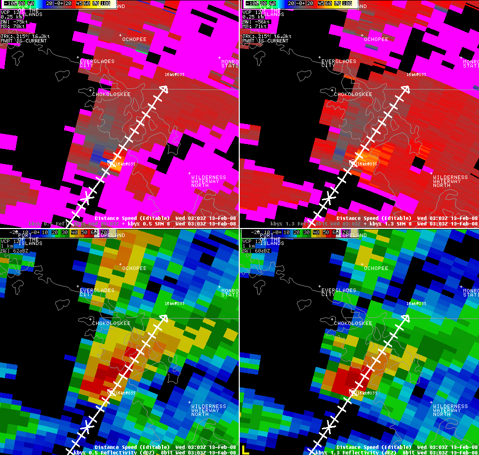
KBYX (Key West) radar high-resolution storm relative velocity and base reflectivity from lowest two elevation slices around time of tornado in Everglades City (10 PM EST). Notice main mesocyclone around 13 miles south-southeast of Everglades City.

KAMX high-resolution storm relative velocity and base reflectivity from lowest two elevation slices around time of tornado in Riverland (1103 PM EST).

Track Map for the tornado in Riverland, just SW of Fort Lauderdale.
|
||||||||||||


 Follow us on YouTube