|
|||||||
| Synopsis and Description of Tornado The combination of a pre-frontal trough of low pressure across South Florida ahead of a cold front across Central Florida, an upper level short wave moving across the area producing very unstable conditions, and sea breeze interactions resulted in a severe thunderstorm producing an EF0 (in the new Enhanced Fujita Scale) tornado which affected northeastern portions of Broward County on February 28, 2007. The EF0 tornado touched down just north of Commercial Boulevard and west of Rock Island Road in Tamarac shortly before 2 PM, with damage in this area consisting primarily of downed tree limbs and branches. The tornado then moved south-southeast across Commercial Boulevard and through the Woodlands Country Club, where the most significant damage was observed. One home suffered some roof damage in the 5700 block of Bayberry Lane, and another house on the same block had a porch screen torn off. The tornado reached its maximum wind intensity of 80 to 85 mph over the Woodlands Country Club. The tornado continued on its south-southeast path near Rock Island Road and just west of the Florida Turnpike, causing damage mostly to vegetation (downed `tree limbs and branches). The tornado lifted near the intersection of the Florida Turnpike and Oakland Park Boulevard in Lauderhill. The tornado path was 2.50 miles and the width was estimated to be around 50-100 yards. No injuries or fatalities occurred. Tamarac Tornado (Broward County)
The supercell thunderstorm which produced the tornado continued moving southeast after the tornado lifted, and became a prolific hail producer. Numerous reports of large hail were received in an area extending from Margate and Tamarac to Lauderhill, North Lauderdale, Lauderdale Lakes, Wilton Manors and Fort Lauderdale, including downtown Fort Lauderdale and Fort Lauderdale Beach. Hail sizes ranged from penny (0.75 inches) to golf ball (1.75 inches). The supercell thunderstorm moved offshore near Port Everglades at approximately 230 PM. Summary of WFO Miami Statements and Warnings: A Special Weather Statement (SPS) was issued by WFO Miami at 1:03 PM alerting of a strong thunderstorm moving south out of Palm Beach County into extreme Northern Broward County. At 1:27 PM, another SPS was issued to update the storm's position near Parkland and Coral Springs. At 1:38 PM, a Severe Thunderstorm Warning (SVR) was issued for Eastern Broward County as the storm continued to intensify based on data from the Miami 88-D doppler radar. Only a few minutes later at 1:42 PM, the SVR was upgraded to a Tornado Warning (TOR) as the radar indicated a Tornado Vortex Signature (TVS), or strong rotation in the thunderstorm indicative of a possible tornado. The first report of the tornado touchdown was at 1:55 PM, giving a total of 13 minutes lead time on the TOR, and 7 minutes on the SVR based on the initial report of penny size hail in Margate. |
 Click for Radar Loop of Storm Evolution with Warnings issued.  Four panel radar reflectivity display of the 4 lowest elevations around the time the first Special Weather Statement was issued (102 EST PM). 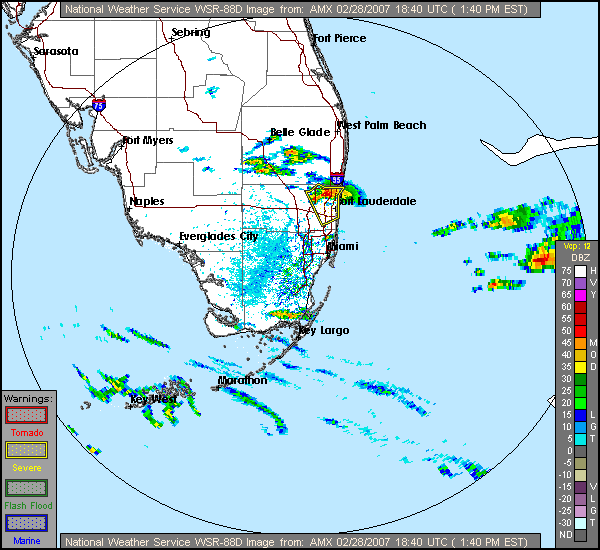 Radar reflectivity image shortly after a Severe Thunderstorm Warning was issued for Broward County at 138 EST PM.  Four panel radar storm relative velocity display of the 4 lowest elevations around the time the Severe Thunderstorm Warning was upgraded to a Tornado Warning at 142 EST PM. 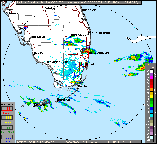 Radar reflectivity image shortly after the tornado warning was issued at 142 EST PM.  Map depicting tornado track. |
||||||


 Follow us on YouTube