|
|||||||||||||||||||||||||||||||||||||||||||||||||||||||||||||||||
| Low pressure in the northeast Gulf of Mexico moved eastward into north Florida, while a trailing cold front moved ashore into southwest Florida during the day on Thursday, March 27th. This brought unusually favorable meteorological conditions (shear profiles and thermo- and hydrodynamic factors) favorable for supercell thunderstorms to Florida, which produced large hail in central Florida, and several tornadoes in South Florida. Eight confirmed tornadoes (seven in the WFO Miami county warning area) touched down in portions of south Florida. The most intense tornado, rated as F2 (113-157 mph) on the Fujita Tornado Damage Scale, hit Miami-Dade County in the Brownsville-Liberty City section at 5:46 P.M. EST. Two other tornadoes, rated at F1 intensity (73-112 mph) occurred, one in Naples and the other in an area from North Miami Beach to Hallandale Beach. Three other tornadoes of unknown intensity occurred in sparsely populated areas of interior south Florida, one at Ochopee in Collier County, a second from near Devils Garden in Hendry County to south of Belle Glade in western Palm Beach County, and a third near the Miccosukee Indian Reservation in west central Miami-Dade County. This tornado outbreak was one of the worst in south Florida in terms of number and intensity of tornadoes. The Brownsville-Liberty City tornado was only the fifth tornado of F2 intensity to be observed in Miami-Dade County since 1950. The strongest and most deadly tornado in Miami-Dade County history occurred on April 5, 1925 when an F3 (158-206 mph) tornado killed 5 people and injured more than 35 in the northern portion of the county. As with the Ground Hog's Day severe weather outbreak in 1998, El Nino conditions were likely influencing south Florida's weather in March of 2003. Naples Tornado (Collier County) A tornado touched down in the Poinciana Village Subdivision. Several house roofs sustained damage to shingles and wood. Trees were also blown down.
Bonita Springs Tornado (Lee County, served by WFO Tampa) A weak tornado crossed Interstate 75 between mile marker 120-123 which is just north of the Lee/Collier county line. The tornado was caught on film and played on several local and national networks. Minimal debris was associated with the tornado as it passed through uninhabited areas of Lee county.
Ochopee Tornado (Collier County) A fire chief photographed a tornado near the intersection of U.S. 41 and SR 29. The tornado did no known damage.
Devils Garden Tornado (Hendry County) A tornado was sighted southeast of Devils Garden moving east. No casualties or damage reported.
Belle Glade Tornado (Palm Beach County) Sugar cane workers sighted a tornado. No casualties or damage were reported.
Miccosukee Tornado (Miami-Dade County) A tornado was reported near the Miccosukee Indian Reservation. No casualties or damage was reported.
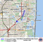
North Miami Beach/Hallandale Beach Tornado (Miami-Dade County) A tornado touched down near the southeast corner of the Presidential Golf Course and traveled northeast before lifting in Hallandale Beach. The maximum intensity (F1) occurred between NE 17th and 19th Avenues from 196th to 200th Streets where several house roofs and screened porches were damaged.
Brownsville/Liberty City Tornado (Miami-Dade County) The tornado initially touched down in East Hialeah, near NE 2nd Street and E 4th Avenue causing F0 damage to foliage. The tornado strengthened to F1 intensity as it moved east across E 9th Avenue. It achieved a maximum intensity of F2 with a maximum width of one third mile in an area from NW 37th to 27th Avenues in the Brownsville area. The intensity decreased to F1 as it moved east through Liberty City. The intensity further decreased to F0 as the tornado turned northeast and lifted just before entering Biscayne Bay near NE 70th Street. F1 to F2 damage began in an industrial area where several warehouse roofs were damaged. One large free-span roof was nearly completely torn off. Several semi-tractor trailers, apparently empty, were toppled, one of which fell onto two cars, crushing them. The tornado moved through a residential area known as Brownsville, heavily damaging 60 houses. At one of the homes, a 65-year old male who was sitting in this house was killed when debris penetrated the structure. His wife who took shelter in the bathroom was uninjured. A total of 343 other structures sustained damage, mostly to roofs and windows. Several vehicles were rolled over. Numerous utility poles were broken, large trees were uprooted and signs were downed.
|
 The first tornado touched down over The Estuary, northwest of Airport and Golden Gate Pkwy in Naples. Photos by Jeffrey Letourneau.  The Ochopee tornado. Photos by Chief Paul Wilson, Ochopee Fire Dept.  From a vantage point near the Miami Int'l Airport, the formative stages of the Brownsville/Liberty City tornado are witnessed. Photos by Mike Theiss.  North Miami Beach & Hallandale Beach tornado swath. Graphic by Rob Handel, NWS Miami.  The Brownsville/Liberty City tornado path. Graphic by Rob Handel, NWS Miami.  Brownsville damage and debris at the home where the one fatality occurred. Photos by Jim Lushine, NWS Miami. |
||||||||||||||||||||||||||||||||||||||||||||||||||||||||||||||||
|
Additional Information
|
|||||||||||||||||||||||||||||||||||||||||||||||||||||||||||||||||