1. INTRODUCTION
On 4 and 5 November 1998, Tropical Storm Mitch moved from the Gulf of Mexico, across south-central Florida, northeast into the Atlantic. Mitch was a "hybrid" system, exhibiting both extratropical and tropical characteristics. Shown by the Eta 6-hour forecast 500 mb heights/temperatures, from the 1200 UTC 4 November 1998 model run (Fig. 1), Mitch had a warm core like a tropical cyclone. The 304K isentropic analysis from the same model and time (Fig. 2), showed a very distinct warm front off the southeast Florida coast with a steep slope in the isentropic surface. Also, the warm front showed up clearly by surface data. At 2200 UTC on 4 November, the temperature/dewpoint at West Palm Beach were 21C/20C respectively, with a north-northeast wind at 10 knots. At Miami, for the same time, the temperature/ dewpoint was 26C/ 25C respectively, and an east wind at 7 knots.
Fig. 1. Eta 6-hour forecast 500 mb
heights and temperatures from 1200
UTC 4 November 1998.
Fig. 2. Eta 6-hour forecast 304K
isentropic surface.
The track of Tropical Storm Mitch across south-central Florida would result in a very favorable environment for supercell thunderstorm development over southeast Florida, especially to the south of the warm front. This provided strong vertical wind shear and moderate instability. This paper presents a look at model and radar data during the passage of Tropical Storm Mitch.
2. OVERVIEW OF MODEL DATA
The 0000 UTC 4 November 1998 Eta model run was available for use in the preparation of forecast products issued Wednesday morning, 24 November. After examining the data, the State Forecast Discussion was prepared and read as follows: "IN ADDITION TO THE HEAVY PRECIP...IT LOOKS LIKE THERE IS A VERY GOOD CHANCE OF SVR TSTMS AND PSBLY EVEN TORNADOES OVER CNTRL AND S FLORIDA TONIGHT AND THU DUE TO HIGH HELICITY VALUES.
The 24 hour forecast of surface to 3 km helicity from the 0000 UTC 4 November 1998 Eta model run is shown in Fig. 3. Maximum values were forecast to be over 800 m2/s2. Since the storm was moving northeast faster than the model indicated, the maximum values of helicity would likely be located further east over southeast Florida at 0000 UTC on 5 November rather than over the southeast Gulf of Mexico.

Fig. 3. Eta 24 hour forecast of
Surface to 3 km Helicity from
0000 UTC 4 November 1998.
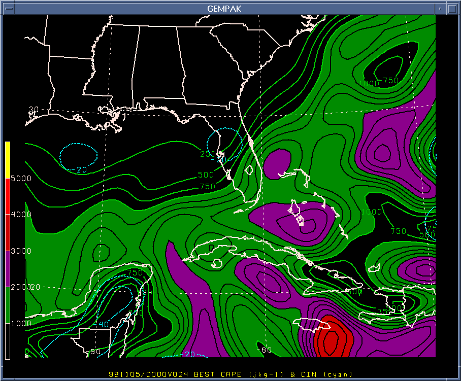
Maximum values of Convective Available Potential Energy (CAPE) were forecasted to be around 1800 joules/kilogram (j/kg) over the Florida Keys as indicated by the 24 hour forecast "best CAPE" from the 0000 UTC 4 November Eta model (Fig. 4). Cloudiness limited the airmass's potential instability over southern Florida during the afternoon and evening hours of 4 November.
Fig. 4. ETA 24 hour forecast of
Best CAPE from 0000 UTC
4 November 1998.
Fig 5. Eta 24 hour forecast of
EHI from 0000 UTC
4 November 1998.
The maximum Energy-Helicity Index (EHI) values were forecasted near Key West at 0000 UTC 5 November (Fig. 5). Again, because Mitch was moving faster northeast than the Eta model forecast, the maximum EHI was also most likely farther east than forecasted.
The Eta model 24 hour forecast model derived sounding for Key West at 0000 UTC 5 November showed strong directional shear from the surface to 800 mb. 1000 mb winds were forecast to be east southeast at 25 knots and increasing and veering to the south at over 50 knots at 800 mb.
The combination of the above model data strongly suggested a forecast environment very favorable for the development of supercell thunderstorms.
The Key West WSR 88-D started showing supercell thunderstorms by the late morning hours of 4 November.
The VAD Wind Profile (VWP) from the Miami (KAMX) WSR-88D indicated strong directional and speed shear from the surface to 9 km. at 2300 UTC 4 November.

Fig 6. KAMX WSR-88D hodograph at 2300
UTC 4 November 1998 from WATADS.
The WSR-88D Algorithm Testing and Display System (WATADS) hodograph from the Miami WSR 88-D (Fig. 6) also showed strong directional/speed shear and a good indicator of supercell development.
The sounding data from Key West and Miami at 0000 UTC 5 November, showed a good verification of the ETA model forecast helicity (assuming a faster forward speed of the storm). Key West had a storm relative helicity of 674 m2/s2, assuming a storm motion of 212 degrees at 30 knots. Miami had a storm relative helicity of 752 m2/s2,assuming a storm motion of 224 degrees at 23 knots.
3. RADAR OVERVIEW
The following sequence of images were extracted from the Miami WSR-88D Archive II data using WATADS. The images show the development of 4 distinct tornado signatures during the life of the supercell thunderstorm as it transversed the middle and upper Florida Keys.
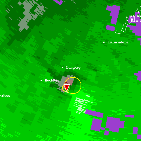
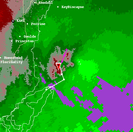
Fig. 7 shows the 1st tornado signature to the south of Long Key over the waters of the Florida Straits. This was 8 minutes after the 1st tornado warning was issued for the middle Florida Keys. At 2242 UTC, Fig. 8 shows the 1st tornado signature dissipating north of Islamorada, with a 2nd strong mesocyclone forming to the southeast of Islamorada which would intensify to form the Key Largo tornado. Fig. 9 shows the 2nd tornado signature at its maximum intensity. A tornado was on the ground producing considerable damage to the northeast part of Key Largo. The 2nd tornado signature was dissipating on the north end of Key Largo by 0010 UTC (Fig. 10). This image also shows a 3rd strong mesocyclone beginning to form just to the east of the north tip of Key Largo. Shortly after at 0027 UTC, the 3rd tornado signature started to dissipate with a 4th one forming to the east (Fig.11). The 4th tornado signature begins to dissipate at 0057 UTC (Fig.12).
Fig. 7. KAMX 88-D .5 degree Base
Velocity 2147 UTC.
Fig. 8. KAMX 88-D .5 degree Base
Velocity 2242 UTC.
Fig. 9. KAMX 88-D .5 degree Base
Velocity 2329 UTC.
Fig. 10. KAMX 88-D .5 degree Base
Velocity 0010 UTC.
Fig. 11. KAMX 88-D .5 degree Base
Velocity 0027 UTC.
Fig. 12. KAMX 88-D .5 degree Base
Velocity 0057 UTC.
Fig 13. KAMX 88-D .5 degree Reflectivity
2335 UTC.
Fig 14. KAMX 88-D .5 degree Base Velocity
2335 UTC with past and forecast
track of tornado overlaid.
Fig. 13 above shows a classic (High Precipitation) HP supercell signature with a very distinct hook just to the northeast of Key Largo near U.S. 1 and Card Sound Road at 2335 UTC. The next image (Fig.14) shows the corresponding Base Velocity with past and forecast track determined by the National Severe Storms Laboratory (NSSL) Tornado Track Algorithm.
4. CONCLUSIONS
At least seven confirmed tornadoes produced extensive damage in the middle and upper Florida Keys during the late afternoon and evening hours of 4 November 1998. Five of the seven were directly associated with the supercell thunderstorm, which moved from the Florida Straits through the middle and upper Florida Keys associated with Tropical Storm Mitch.
This severe weather event was well anticipated by the meteorologists at the National Weather Service Office in Miami. Warnings and statement were issued at frequent intervals during this event. Residents in the middle and upper Florida Keys received a minimum of 20 minutes lead time between the first tornado warning and the first confirmed touchdown.
The first confirmed tornado report came from Grassy Key and Layton (east of Marathon in the middle Keys) at 2200 UTC (500 PM EST). Tornado damage was also reported on U.S. Highway 1 at Mile Marker 80 east of Marathon at 2210 UTC (510 PM EST). Additional damage was reported near Mile Marker 98, with the most severe damage and injuries between Mile Marker 100 and 106 near Key Largo around 2325 UTC (625 PM EST) including an overturned tractor trailer truck.
Through the combined efforts of the National Weather service Office in Miami, the Monroe County Emergency Operations Center (EOC) and the local South Florida media, no lives were lost.
5. REFERENCES
Hart, John A., Josh Korotky, Greg Johnson: The Sharp Workstation V(2/98), Skew-T/Hodograph Analysis and Research Program.
Moller, Alan R., Charles A. Doswell III, Michael Foster, Gary Woodall,1994: The Operational Recognition of Supercell Thunderstorm Environments and Storm Structures. Weather and Forecasting: Vol. 9, No. 3, pp. 327-347.
Spratt, Scott M., David Sharp, Pat Welsh, Al Sandrick, Frank Alsheimer, Charlie Paxton, 1997: A WSR- 88D Assessment of Tropical Cyclone Outer Rainband Tornadoes. Weather and Forecasting: Vol. 12, No. 3, pp. 479-501.
Staff, Stormscale Research and Applications Division, 2000: WSR-88D Algorithm Testing and Display System (WATADS) Reference Guide for version 10.2. National Severe Storms Laboratory (NSSL), 1313 Halley Circle, Norman, Ok. 73069.
Welsh, Pat, 1997: Lessons Learned in Configuring and Using the Nexrad (WSR-88D) Radar for Detection of Tropical Cyclone Induced Tornadoes (TCIT). Preprint from 28th Conference on Radar Meteorology, pp. 582-583.


 Follow us on YouTube