Chicago, IL
Weather Forecast Office
 |
|
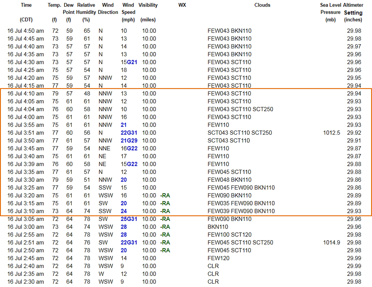
NWS Chicago Doppler Radar loop and airport observations from 1 a.m. through 5 a.m. on July 16. Note light reflectivity moving southward across the Chicago metro area. It's passage correlated to: 1.) a sharp drop in air pressure likely due to a wake low, 2.) strong wind gusts correlating with the pressure change, 3.) then shortly after, a rapid jump in temperature and 4.) a drop in moisture. The last two in this list are particularly interesting. This light reflectivity and associated rapid weather change originated from storms that had quickly dissipated over far southeast Wisconsin. Notice how storms quickly collapse across McHenry and Kane Counties too which may have also had an effect. |
...Maximum Wind Gusts... Location Speed Time/Date ---------------------------------------------------- Chicago Midway 40 MPH 0331 AM 07/16 Rockford Airport 39 MPH 0322 AM 07/16 Chicago O'Hare 37 MPH 0254 AM 07/16 Kankakee Airport 37 MPH 0533 AM 07/16 Chicago Harrison-Dever Crib 36 MPH 0300 AM 07/16 Dupage Airport 32 MPH 0402 AM 07/16 Lewis Airport, Romeoville 31 MPH 0455 AM 07/16 |
 |
|
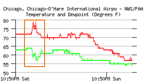
| Chicago O'Hare International Airport observations, with the box indicating the observed sharp warming and drying. The temperature warmed from 72° to 79° between 3:05 a.m. and 3:30 a.m. | |
 |
|
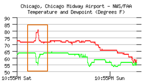
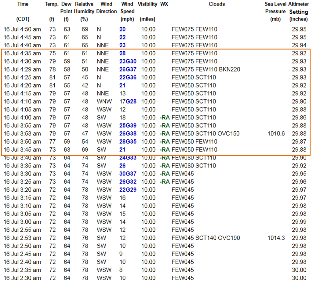
| Chicago Midway International Airport observations, with the box indicating the observed warming and drying. The temperature warmed from 73° to 81° between 3:45 a.m. and 3:55 a.m. | |
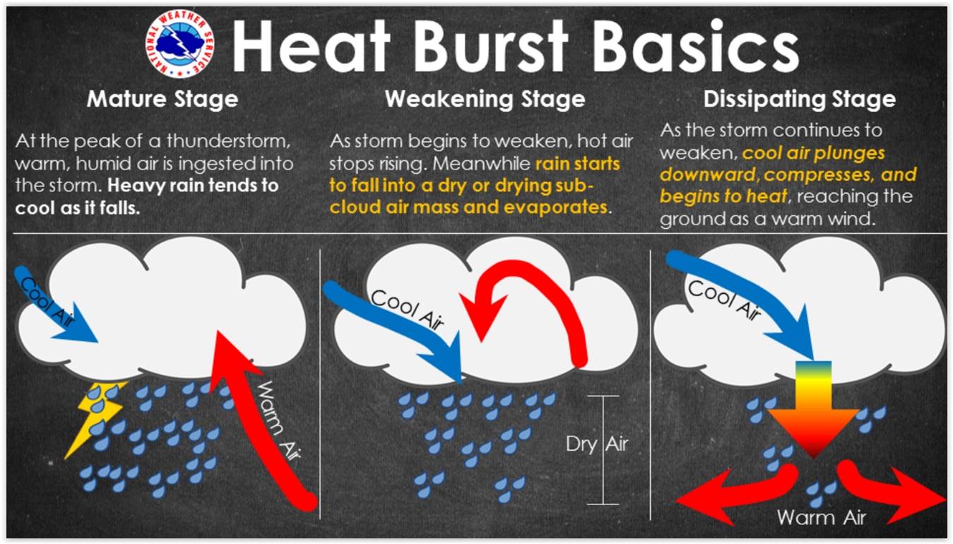 |
| Heat burst infographic courtesy of NWS Sioux Falls, SD. A heat burst, or at least a phenomenon with similar traits, is suspected to have occurred in northeast Illinois during the early morning of July 16 . Typically a true heat burst happens over a smaller area and closer to where the storms collapsed than what was observed. Also, they are most commonly found in the Plains states, though still not common. They are exceptionally rare in northern Illinois. |
Hazards
Enhanced Hazardous Weather Outlook
Hazardous Weather Outlook
National Briefing
Skywarn
Outlooks
Watch/Warning/Advisory Criteria
Snow Squall Warnings
Local Forecasts
Text Products
Aviation
Marine
Fire
Enhanced Data Display (EDD)
Great Lakes Marine Portal
Lake Michigan Beach Forecast
El Nino
Snow and Ice Probabilities
Past Weather
Stormdata
Holiday Climate Data
Climate Plots
Weather Event Write-Ups
Education
Jetstream
Student Opportunities
NWS Training Portal
Play Time for Kids
US Dept of Commerce
National Oceanic and Atmospheric Administration
National Weather Service
Chicago, IL
250 George J Michas Dr.
Romeoville, IL 60446
815-834-1435 8am-8pm
Comments? Questions? Please Contact Us.