Summary
|
 |
Tornadoes
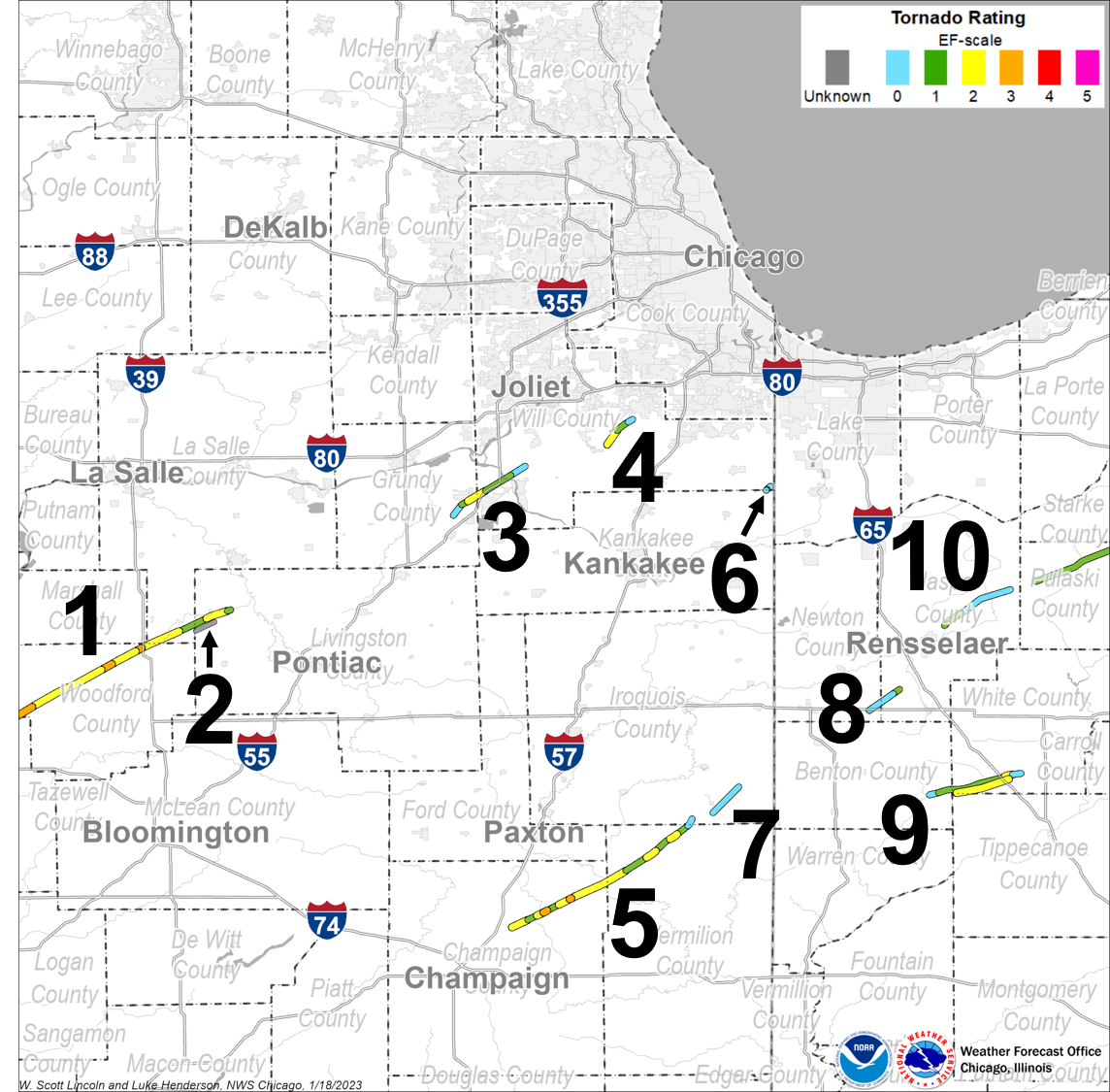
1.) East Peoria - Washington - Long Point, IL EF-4
Summary: Note: This tornado began farther to the southwest than depicted on the above maps. For additional details on this tornado, including information on the Washington, IL area, see NWS Lincoln's page on this tornado. A tornado touched down 2.4 miles SE of East Peoria at 10:59 AM CST, then tracked northeastward through parts of East Peoria, where 20 homes were destroyed and 75 homes, 7 businesses, and 5 apartment buildings suffered major damage. Minor damage occurred to 137 homes and 3 businesses. The tornado strengthened to EF-4 intensity and widened to between 1/4 and 1/2 mile wide as it moved northeast into Washington. In Washington, 633 homes, 7 businesses, 7 apartment buildings, and 2,500 vehicles were destroyed. Major damage occurred to 280 homes, 2 businesses, the roof of a school, and several outbuildings. Minor damage occurred to another 190 homes. The tornado moved out of Washington and across another 2 miles of rural Tazewell County before crossing the border into Woodford County. The tornado then moved northeastward across rural Woodford County, where it weakened a bit to EF-3 intensity but remained between 1/4 and 1/2 mile wide. During much of its time in Woodford County, the tornado traveled across open fields, impacting dozens of farmsteads. Nearly 70 farm buildings and 7 homes were destroyed. Major damage occurred to 17 homes, while 23 others received minor damage. The tornado entered La Salle County approximately half a mile east of State Route 251 north of Minonk, where several power poles were snapped at the base along County Line Road. On E 7th Road, a home had large portions of the roof removed. Small outbuildings were completely destroyed. More power poles were snapped on E 8th Road and again on N 2nd Road near the intersection of E 10th Road. A machinery shed was completely destroyed on N 2nd Road about half a mile west of Dana. On E 11th Road just north of Dana, an addition to a home was completely leveled with several outbuildings destroyed. The tornado entered Livingston County about a third of a mile north of E 2400 N Road where power poles were leaning. Several outbuildings were heavily damaged or destroyed on E 2475 N Road. Hardwood trees were snapped on N 200 E Road as well as wooden power poles. A large shed housing a fire engine was completely destroyed with the fire engine rolled onto its side on Long Point Blacktop Road near the intersection of N 400 E Road. On the northeast side of that intersection, a wooded area saw extensive tree damage with numerous trees sheared off about 20 to 30 feet from their bases. The damage path ended about half a mile north of Long Point Blacktop Road between N 450 E Road and Route 23. This tornado had a path length of 46.3 miles and a maximum width of 880 yards. The tornado began at 10:59 AM CST and ended at 11:47 AM CST. This tornado caused 3 fatalities and 125 injuries. |
2.) Long Point, IL EF-0
Summary: Video was received from a storm chaser showing a satellite tornado that formed just south of the long-tracked tornado that had moved into Livingston County. This tornado only lasted a few minutes and appeared to stay over open fields with no damage evident. This tornado had a path length of approximately 2.6 miles and a maximum width estimated at 50 yards. The tornado began about 11:43 AM CST and ended at about 11:46 AM CST. |
3.) Coal City - Diamond - Wilmington, IL EF-2
Summary: This tornado formed just northwest of the intersection of E Braceville Road and S Carbon Hill Road, where several softwood trees were uprooted. The tornado moved northeast just north of E Reed Road, where a single family residence sustained visible damage to its exterior while a metal outbuilding sustained roof and exterior wall damage. A single family home sustained considerable damage near the intersection of Berta Road and Spring Road, where two people were injured. The tornado continued into a subdivision north of Spring Road where widespread minor damage occurred to several dozen homes. Several homes received more substantial damage, though, including partial loss of roofs and second story walls. The tornado moved into Will County on N Will Road just south of State Route 113. There was considerable damage to businesses on State Route 113 between N Will Road and I-55. An RV dealership had numerous vehicles overturned and damaged. A two story structure lost its roof and had portions of its walls ripped off. A model home was completely removed from its foundation on the north side of State Route 113. A manufactured building had its roof ripped off with all the walls collapsed. Widespread tree damage was observed along the west side of I-55, which the tornado almost tracked parallel to as it weakened. The tornado crossed I-55 near Widows Road, where several hardwood trees were uprooted. The tornado then tracked into the Midewin Tallgrass Prairie, where it damaged several metal structures just west of Route 53. The tornado lifted just east of Route 53. This tornado had a path of 12.4 miles and a maximum width of 200 yards. The tornado began at 12:22 PM CST and ended at 12:33 PM CST. This tornado caused 5 injuries. |
4.) Manhattan - Frankfort, IL EF-2
Summary: This tornado touched down south of W Bruns Road and east of S Kankakee Street. It quickly intensified to EF-2 intensity, damaging five houses along Bruns Road and rendering them uninhabitable by removing large sections of the roofs and leading to partial wall collapse. Four high tension power line towers were bent along S Schoolhouse Road. Two houses and a barn were heavily damaged on W Dralle Road, where large portions of the roofs were ripped off. Several trees were snapped and uprooted as well. Another farm on S Scheer Road had roof damage consistent to EF-1 intensity. The last sign of damage occurred just south of Steger Road, where large branches were blown down. This tornado had a path length of 5.4 miles and a maximum width of 200 yards. The tornado began at 12:42 PM CST and ended at 12:48 PM CST. |
5.) Thomasboro - Gifford - Wellington, IL EF-3
Summary: Note: This tornado began farther to the southwest than depicted on the above map. For additional details on this tornado, including information on the Gifford, IL area, see NWS Lincoln's page on this tornado. This tornado touched down in an open field about 1 mile SE of Thomasboro and rapidly moved to the northeast. In less than a minute, it increased in intensity, causing damage to 3 nearby farms and pushing 2 farm houses off their foundations. The tornado moved through open fields for about 2 miles, at which time, it widened to nearly 1/4 mile wide and became wrapped in rain. It destroyed 3 homes, several outbuildings, and damaged a few other homes before nearing Gifford. The rain-wrapped tornado was about 1/2 mile wide when it moved through the center of Gifford. Nearly 30 homes were destroyed, more than 40 suffered major damage, and around 125 had minor damage. Around 15 businesses sustained moderate to major damage and the roof of a school was peeled back. Hundreds of vehicles were damaged or destroyed. The tornado tracked for another 5 miles to the northeast, destroying 3 homes and numerous outbuildings, damaging several other homes, and snapping many trees and power poles. This tornado crossed into Vermilion County 4.1 miles NW of Armstrong, then tracked northeastward across rural northwest Vermilion County. There, the tornado destroyed 1 home, 20 outbuildings, and a camper. It also damaged 7 other homes and snapped numerous power poles and trees. The tornado weakened as it moved out of Vermilion County. This tornado briefly crossed into southern Iroquois County southwest of Wellington. Three homes there had minor damage caused to either outbuildings or large trees before the tornado lifted. This tornado had a path length of 29.7 miles and a maximum width of 880 yards. The tornado began 12:45 PM CST and ended at 1:15 PM CST. This tornado caused 6 injuries. |
6.) Beecher, IL EF-1
Summary: The tornado formed along the Kankakee-Will County Line just west of N 17480 E Road. Large branches from hardwood trees were broken off, while an older softwood tree was snapped at the base. A hardwood tree was also snapped in half. The tornado moved northeast into Will County just west of N 17480 E Road. A large barn sustained significant damage to its roof and outer walls. Two adjacent metal outbuildings also had partial roof loss. Several softwood trees were snapped at the base or half way up with debris lofted about a thousand feet. A 400 lb tractor blade was moved about 60 feet, while a grain pipe that had been riveted to the silo was ripped away. Minor damage was noted to trees along E Delite Inn Road, as well as to small barns and outbuildings. This tornado had a path length of 0.9 miles and a maximum width of 150 yards. The tornado began at 1:00 PM CST and ended at 1:02 PM CST. |
7.) Wellington, IL EF-0
Summary: Four farms were impacted by this tornado near Wellington with several large trees downed or snapped. One outbuilding also had its roof torn off. This tornado had a path length of 5.5 miles and a maximum width of 75 yards. The tornado began at 1:19 PM CST and ended at 1:23 PM CST. |
8.) Goodland, IN EF-1
Summary: This tornado touched down in Goodland, causing several large grain bins to cave in on themselves with some of the surrounding scaffolding collapsing. This portion of the storm was consistent with high-end EF-0 damage. The tornado mainly passed over open fields; however, near the end of its path, an outbuilding was destroyed and small farm equipment moved, including one piece that was rolled into a grain storage bin. Debris was noted as far as a mile downstream. This tornado had a path length of 5.2 miles and a maximum width of 100 yards. The tornado began at 1:27 PM CST and ended at 1:32 PM CST. |
9.) Otterbein - Brookston, IN EF-2
Summary: Note: This tornado ended farther to the east than depicted on the above map. For additional details on this tornado, see NWS Northern Indiana's event write-up page. This tornado heavily damaged an outbuilding with several wood projectiles from the building stuck into a nearby garage roof. Debris from the outbuilding was lofted at least three miles downstream. Another outbuilding was heavily damaged and multiple trees were blown down or snapped. The tornado moved into southwestern White County south of County Road 1200 South, where the garage door of a west-facing pole barn was pushed in and some minor tree limb damage was noted. The tornado continued rapidly northeast and impacted a residence on 900 West, where the chimney (above the roof) was knocked down with shingle damage noted to the home. In addition, a large propane tank and camper were rolled or pushed roughly 150 feet away with the camper being destroyed. The tornado moved into open fields, where it remained for roughly four miles, crossing I-65 between mile markers 188 and 190. The tornado briefly strengthened after crossing the interstate, snapping ten 18-24 inch diameter power poles at the ground along County Road 500 West, either side of State Route 18. A home on the intersection of these roads suffered minor window and roof damage. Just east of the intersection, a pole barn was destroyed with debris thrown upwards of three-quarters of a mile. The tornado finally lifted west of County Road 300 West and north of State Route 18. This tornado had a path length of 12.1 miles and a maximum width of 1200 yards. The tornado began at 1:40 PM CST/2:40 PM EST and ended at 1:55 PM CST/2:55 PM EST. |
10.) Rensselaer - Medaryville, IN EF-1
Summary: Multiple empty grain bins and outbuildings were destroyed across four farmsteads with large paths of debris thrown two miles downstream. Utility poles were blown down along with dozens of trees that were snapped. This tornado had a path length of 10.5 miles and a maximum width of 100 yards. The tornado began at 1:50 PM CST and ended at 2:00 PM CST. |
The Enhanced Fujita (EF) Scale classifies tornadoes into the following categories:
| EF-0 Weak 65-85 mph |
EF-1 Moderate 86-110 mph |
EF-2 Significant 111-135 mph |
EF-3 Severe 136-165 mph |
EF-4 Extreme 166-200 mph |
EF-5 Catastrophic 200+ mph |
 |
|||||
Radar
|
|
|
|
|
|
|
|
|
|
|
|
|
|
|
|
Environment and Forecast Services
While severe thunderstorms are extremely complex, the ingredients they need to develop come down to a few simple ones: 1.) warmth and moisture, which create instability; 2.) strong turning winds with height (i.e. wind shear); and 3.) a focus for rising air, such as a cold front. The stronger these parameters are, especially wind shear, the greater the potential for tornadoes.
In November, environmental winds tend to be much stronger than in the summer or even spring months. This leads to greater wind shear. Normally, however, during the late autumn and into winter, we do not have sufficient warmth and moisture for thunderstorm development. A powerful low pressure system across the Plains states had steered warmth and moisture northward for nearly two days, bringing summerlike moisture levels (dew points in the mid 60s) into the region. Given air temperatures of around 70°, there was more than enough instability to get thunderstorms to go, and this instability happened to be off the charts for November. Combine that with the high wind shear and a cold front sweeping eastward, and you had all of the ingredients you needed for thunderstorms, particularly supercell thunderstorms capable of producing tornadoes. With severe weather parameters all extremely high for any time of the year, long-lived significant tornadoes became likely.
|
Map of surface weather conditions on November 17, 2013, from 4:00 AM to 5:00 PM. Colors depict dewpoint temperatures. |
|
Maps of various severe weather parameters on November 17, 2013. The high wind shear values, high instability levels, and low cloud base heights combined to create an environment that was favorable for strong and long-lived tornadoes. |
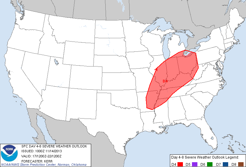
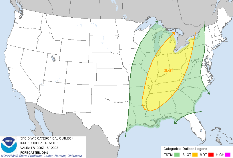
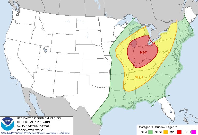
The potential for severe weather to occur on the 17th had been realized several days in advance by NWS meteorologists with the Storm Prediction Center (SPC) issuing a severe weather outlook for the region as early as Thursday, November 14th. Severe weather probabilities for the region in the SPC's Convective Outlook were escalated each subsequent day leading up to the event, culminating in a High Risk being issued for the area on the morning of the 17th. As of November 17, 2023, this is the last time that a High Risk was issued for northeast Illinois and northwest Indiana.
 |
 |
 |
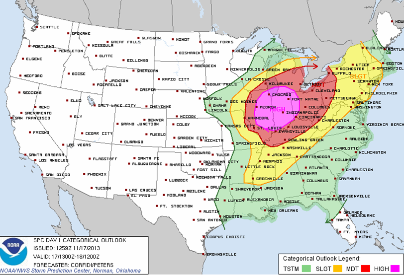 |
| SPC Day 4 Convective Outlook for November 17, 2013, issued Thursday, November 14. | SPC Day 3 Convective Outlook for November 17, 2013, issued Friday, November 15. | SPC Day 2 Convective Outlook for November 17, 2013, issued Saturday, November 16. | SPC Day 1 Convective Outlook, issued the morning of Sunday, November 17. |
|
Tornado Watch issued at 8:40 AM CST on November 17, 2013, indicating a high likelihood of strong tornadoes occurring. |
|
|
|
| Severe weather warnings issued on November 17, 2013. | Severe weather warnings issued on November 17, 2013, zoomed in to northeast Illinois and northwest Indiana. |
Climatology
Below is a list of all of the tornadoes that occurred in the NWS Chicago county warning area (CWA) prior to November 17, 2013 (dating back to 1950). There had been a total of twelve before this outbreak that occurred in a total of six severe weather events (basically one such event every decade). Note that eight of the November tornadoes were EF-2 or stronger, showing that when tornadoes do occur in November, there is a decent likelihood that they will be significant (EF-2 or stronger). The primary reason for this is that the strong dynamics and wind fields that tend to be present in the cool season (late autumn and winter) lead to a greater amount of wind shear. This is a key ingredient for tornadoes, and the greater the wind shear, the greater the likelihood for significant tornadoes.
November tornadoes to occur in the NWS Chicago CWA since 1950 (before November 17, 2013):
Date Time County Rating
11/13/1951 400 PM LAKE [IN] F2
11/26/1951 617 PM FORD F1
11/12/1965 248 PM DU PAGE F2
11/12/1965 345 PM COOK F2
11/12/1965 205 PM LA SALLE F2
11/12/1965 235 PM GRUNDY F2
11/12/1965 300 PM WILL F2
11/12/1965 453 PM LAKE [IN] F3
11/11/1971 1100 PM LIVINGSTON F1
11/10/1975 UNK LAKE [IL] F1
11/09/1984 640 PM WILL F0
11/22/2010 304 PM WINNEBAGO EF2
|
|
Illinois tornadoes in November
The National Weather Service has tornado statistics dating back to 1950. Tom Grazulis published “Significant Tornadoes 1680-1991”. A significant tornado is defined as a tornado that was rated F-2 or greater and/or a tornado that caused at least 1 fatality or 10 injuries.
Using Grazulis’ data from 1885 through 1949 and NWS data from 1950 through 2012, there were 30 F-2/EF-2 tornadoes and 8 F-3/EF-3 tornadoes documented in Illinois in the month of November. There had never been an F-4/EF-4 (or F-5/EF-5) tornado in Illinois in November until 2013. There were only 5 documented killer November tornadoes in Illinois from 1885 through 2012. The most fatalities from any November tornado or tornado outbreak was 2 on three separate occasions - November 17, 1892, November 11, 1911, and November 12, 1965. The greatest number of significant tornadoes (F-2/EF-2 or greater) in a November outbreak was seven F-2 tornadoes on November 12, 1965.
 |
Media use of NWS Web News Stories is encouraged! Please acknowledge the NWS as the source of any news information accessed from this site. Additional recaps can be found on the NWS Chicago Past Events Page |
 |