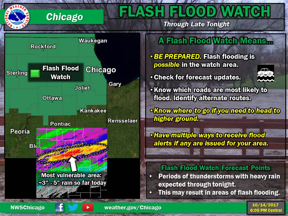
Overview
|
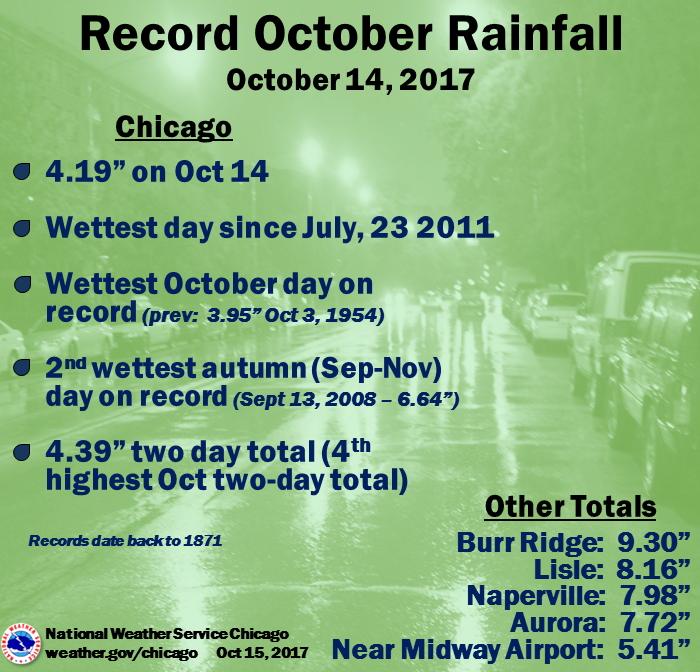
Fast Facts/Records Set:
|
|
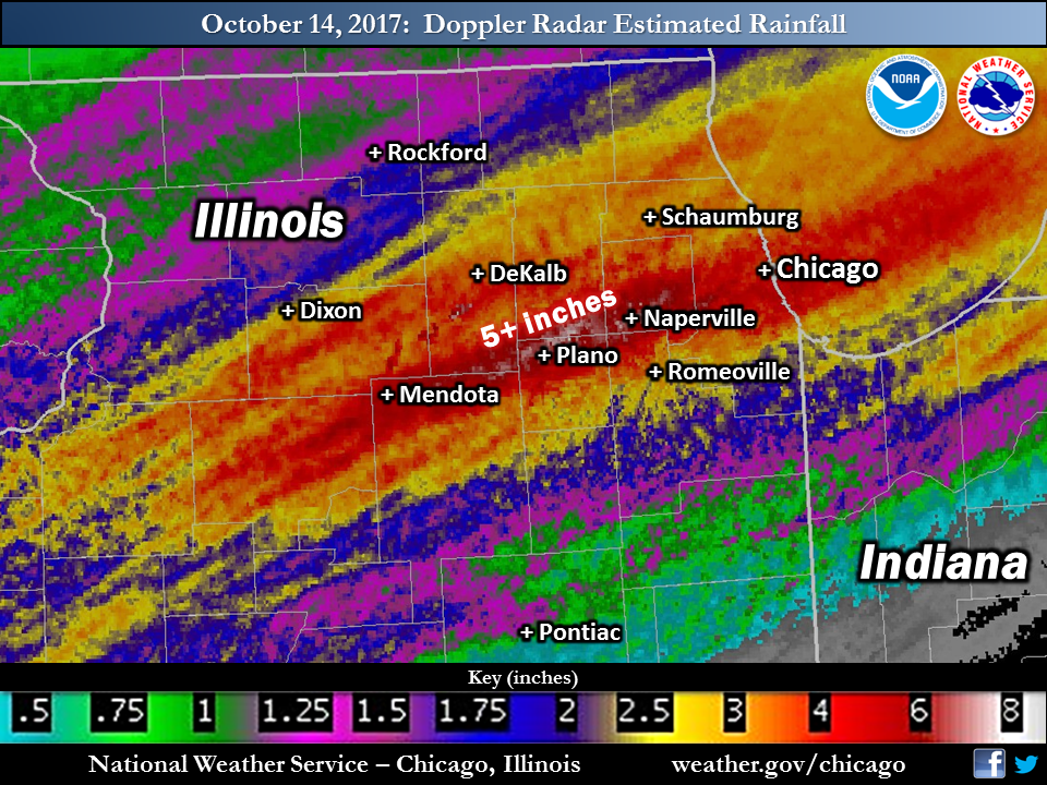
Observed Rainfall
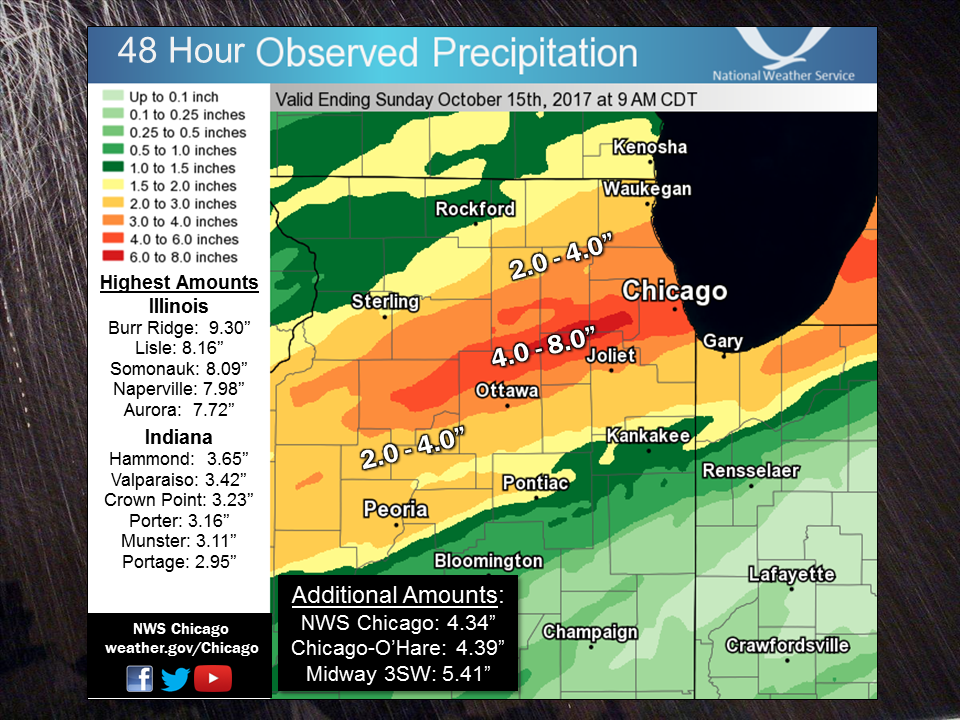 |
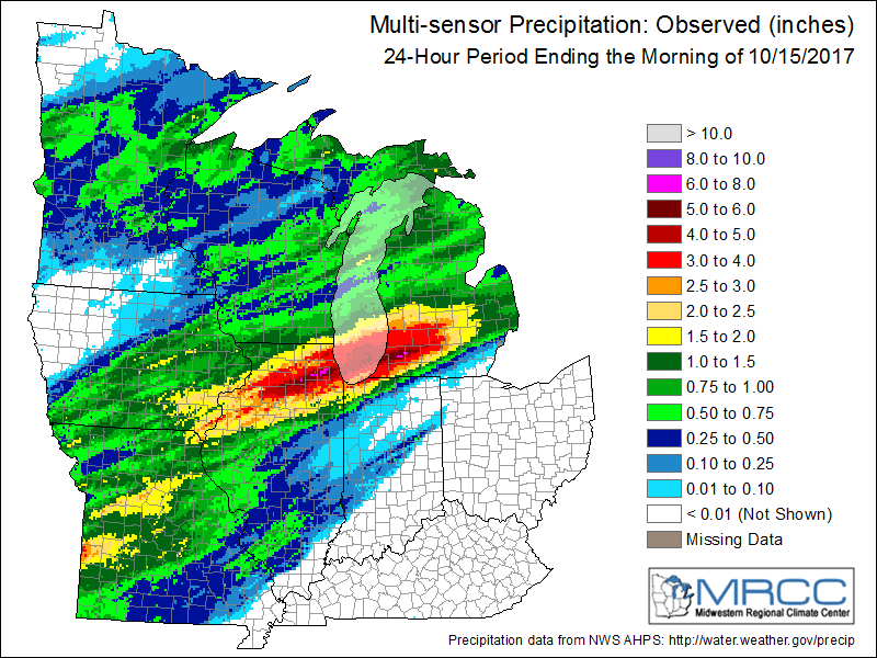 |
| Oct. 14-15, 2017 local area rainfall (see here for a radar-based estimate) | Oct. 14-15, 2017 midwest rainfall (courtesy of the MRCC) |
PUBLIC INFORMATION STATEMENT
NATIONAL WEATHER SERVICE CHICAGO/ROMEOVILLE IL
1022 AM CDT SUN OCT 15 2017


...2-DAY RAINFALL ROUND-UP...

THE FOLLOWING ARE RAINFALL AMOUNTS FOR THE PREVIOUS 2 DAYS
AS MEASURED IN THE MORNING BY NWS COOPERATIVE OBSERVERS
AND COCORAHS OBSERVERS. OBSERVATIONS ARE USUALLY
TAKEN AT 7 AM.

  2-DAY RAIN TOTALS FOR SUNDAY (10/15/17)
     AS OF 10:22 AM CDT

ILLINOIS                                 2-DAY RAINFALL
  LOCATION (COUNTY):                         AMT(IN) REPORTS

  BURR RIDGE 1ESE (COOK).......................9.30     (2)
  LISLE (DU PAGE)..............................8.16     (2)
  SOMONAUK 2NE (DE KALB).......................8.09     (2)
  NAPERVILLE 2ESE (DU PAGE)....................7.98     (2)
  AURORA (KANE)................................7.72     (2)
  AURORA 4SE (DU PAGE).........................7.66     (2)
  AURORA 4SE (DU PAGE).........................7.50     (2)
  MONTGOMERY 1SSE (KENDALL)....................7.43     (2)
  WESTMONT (DU PAGE)...........................7.25     (2)
  OAK PARK 1NNE (COOK).........................7.13     (2)
  DOWNERS GROVE 1S (DU PAGE)...................7.10     (2)
  GLEN ELLYN 2SSE (DU PAGE)....................6.95     (2)
  SOMONAUK (DE KALB)...........................6.89     (2)
  EARLVILLE 3S (LA SALLE)......................6.85     (2)
  NAPERVILLE 4SSW (WILL).......................6.77     (2)
  OAK PARK 2S (COOK)...........................6.73     (2)
  CHICAGO 6ESE (COOK)..........................6.49     (2)
  NORTH AURORA 2NE (KANE)......................6.48     (2)
  MENDOTA (LA SALLE)...........................6.44     (2)
  EARLVILLE 5NNE (DE KALB).....................6.16     (2)
  ELMHURST 1ESE (DU PAGE)......................6.14     (2)
  CHICAGO 5NE (COOK)...........................6.07     (2)
  BURR RIDGE 2SW (DU PAGE).....................6.00     (2)
  SUGAR GROVE 1ENE (KANE)......................5.86     (2)
  GLEN ELLYN 1WSW (DU PAGE)....................5.86     (2)
  ST. CHARLES (KANE)...........................5.85     (2)
  MENDOTA (LA SALLE)...........................5.78     (2)
  SUGAR GROVE 1NE (KANE).......................5.74     (2)
  BRIDGEVIEW 1NNW (COOK).......................5.63     (2)
  BATAVIA 1WSW (KANE)..........................5.55     (2)
  MIDWAY COOP (COOK)...........................5.41     (2)
  BATAVIA (KANE)...............................5.34     (2)
  AURORA (KANE)................................5.30     (2)
  YORKVILLE 2SSE (KENDALL).....................5.25     (2)
  LOMBARD 1NNW (DU PAGE).......................5.10     (2)
  BATAVIA 2WNW (KANE)..........................5.06     (2)
  PLAINFIELD (WILL)............................5.05     (2)
  BATAVIA 1WNW (KANE)..........................5.02     (2)
  OSWEGO 5SSE (KENDALL)........................5.00     (2)
  GENEVA 1SSW (KANE)...........................4.88     (2)
  OAK LAWN 2SE (COOK)..........................4.78     (2)
  ELBURN (KANE)................................4.77     (2)
  WHEATON 2NNE (DU PAGE).......................4.75     (2)
  LEMONT (COOK)................................4.74     (2)
  OAK LAWN (COOK)..............................4.74     (2)
  DE KALB (DE KALB)............................4.63     (2)
  LONG GROVE 1NNE (LAKE).......................4.59     (2)
  WILLOW SPRINGS (COOK)........................4.58     (2)
  LAKE FOREST 2NNE (LAKE)......................4.54     (2)
  LINCOLNWOOD 2E (COOK)........................4.54     (2)
  EVANSTON 1N (COOK)...........................4.49     (2)
  PLAINFIELD 5SW (KENDALL).....................4.40     (2)
  PLAINFIELD 3ESE (WILL).......................4.39     (2)
  OHARE (COOK).................................4.39     (2)
  PLAINFIELD 3SE (WILL)........................4.38     (2)
  SCHAUMBURG 2E (COOK).........................4.38     (2)
  CAROL STREAM (DU PAGE).......................4.35     (2)
  ROMEOVILLE (WILL)............................4.34     (2)
  LINCOLNSHIRE 1N (LAKE).......................4.28     (2)
  GLENCOE (COOK)...............................4.27     (2)
  CHICAGO RIDGE (COOK).........................4.26     (2)
  ROMEOVILLE (WILL)............................4.25     (2)
  HIGHWOOD 1S (LAKE)...........................4.25     (2)
  PARK RIDGE 1WNW (COOK).......................4.24     (2)
  DE KALB (DE KALB)............................4.23     (2)
  BUFFALO GROVE 2N (LAKE)......................4.21     (2)
  PLAINFIELD 2SSE (WILL).......................4.19     (2)
  PALOS PARK 1SW (COOK)........................4.19     (2)
  JOLIET 2N (WILL).............................4.18     (2)
  ARLINGTON HEIGHTS 1SW (COOK).................4.17     (2)
  ELK GROVE VILLAGE 2WSW (COOK)................4.13     (2)
  BURNHAM-HEGEWISCH 2NNW (COOK)................4.09     (2)
  STEWARD (LEE)................................4.07     (2)
  WEST CHICAGO (DU PAGE).......................4.07     (2)
  BOTANIC GARDENS (COOK).......................4.05     (2)
  LAKE ZURICH (LAKE)...........................4.05     (2)
  ARLINGTON HEIGHTS 3SSW (COOK)................4.05     (2)
  DE KALB 1SW (DE KALB)........................4.00     (2)
  WORTH (COOK).................................4.00     (2)
  HOMER GLEN 1ENE (WILL).......................3.99     (2)
  LOCKPORT 1SE (WILL)..........................3.98     (2)
  SHERIDAN 3SSE (LA SALLE).....................3.94     (2)
  HOFFMAN ESTATES 5W (COOK)....................3.92     (2)
  BARRINGTON (LAKE)............................3.88     (2)
  ELGIN 8WSW (KANE)............................3.82     (2)
  CORTLAND (DE KALB)...........................3.79     (2)
  STREAMWOOD (COOK)............................3.77     (2)
  LAKE BLUFF 1W (LAKE).........................3.76     (2)
  ROCHELLE (OGLE)..............................3.74     (2)
  ELGIN 1S (KANE)..............................3.62     (2)
  ELGIN (KANE).................................3.62     (2)
  WAUKEGAN 2N (LAKE)...........................3.57     (2)
  WHEELING (COOK)..............................3.55     (2)
  PARK FOREST (COOK)...........................3.55     (2)
  ELGIN 2WNW (KANE)............................3.51     (2)
  MORRIS 5NNW (GRUNDY).........................3.51     (2)
  PALATINE 1E (COOK)...........................3.48     (2)
  PARK FOREST 1NNE (COOK)......................3.45     (2)
  MARSEILLES 5WNW (LA SALLE)...................3.43     (2)
  ELGIN 2W (KANE)..............................3.41     (2)
  NEW LENOX 2SE (WILL).........................3.40     (2)
  CRYSTAL LAKE 5ENE (MCHENRY)..................3.39     (2)
  HOMEWOOD (COOK)..............................3.39     (2)
  ELGIN (KANE).................................3.36     (2)
  ASHTON (LEE).................................3.32     (2)
  ST. CHARLES 6NW (KANE).......................3.31     (2)
  MINOOKA (GRUNDY).............................3.31     (2)
  NEW LENOX 3E (WILL)..........................3.28     (2)
  COAL CITY 3N (GRUNDY)........................3.27     (2)
  ALSIP (COOK).................................3.25     (2)
  MANHATTAN 2SE (WILL).........................3.24     (2)
  ELWOOD 5NE (WILL)............................3.24     (2)
  GENOA (DE KALB)..............................3.22     (2)
  MUNDELEIN (LAKE).............................3.19     (2)
  MIDLOTHIAN (COOK)............................3.19     (2)
  CARBON HILL 3.1N (GRUNDY)....................3.17     (2)
  COAL CITY 4NNW (GRUNDY)......................3.17     (2)
  MORRIS 6ESE (GRUNDY).........................3.14     (2)
  MUNDELEIN 2WNW (LAKE)........................3.13     (2)
  CHANNAHON 2SSE (WILL)........................3.12     (2)
  MIDLOTHIAN 1SE (COOK)........................3.07     (2)
  FLOSSMOOR 1ESE (COOK)........................3.07     (2)
  DEKALB (DE KALB).............................3.06     (2)
  FLOSSMOOR (COOK).............................3.05     (2)
  DIXON 2SW (LEE)..............................3.04     (2)
  LANSING (COOK)...............................3.01     (2)
  MUNDELEIN (LAKE).............................3.01     (2)
  MANHATTAN 5ENE (WILL)........................2.99     (2)
  WAUKEGAN 2E (LAKE)...........................2.94     (2)
  MANHATTAN (WILL).............................2.86     (2)
  WILMINGTON 3SE (WILL)........................2.79     (2)
  BULL VALLEY 2WNW (MCHENRY)...................2.75     (2)
  LAKE VILLA 2WSW (LAKE).......................2.67     (2)
  LAKEMOOR 2SE (LAKE)..........................2.60     (2)
  NEW LENOX 4SE (WILL).........................2.59     (2)
  ROUND LAKE 2WNW (LAKE).......................2.55     (2)
  PEOTONE (WILL)...............................2.51     (2)
  CRYSTAL LAKE 1WSW (MCHENRY)..................2.51     (2)
  MCHENRY (MCHENRY)............................2.49     (2)
  MONEE (WILL).................................2.45     (2)
  BEECHER 3ENE (WILL)..........................2.41     (2)
  CRETE 3E (WILL)..............................2.40     (2)
  WOODSTOCK (MCHENRY)..........................2.34     (2)
  JOLIET LOCK/DAM (WILL).......................2.33     (2)
  FOX LAKE 2SE (LAKE)..........................2.30     (2)
  KINGSTON 2WNW (DE KALB)......................2.30     (2)
  WONDER LAKE 1NE (MCHENRY)....................2.29     (2)
  LANSING (COOK)...............................2.28     (2)
  HEBRON (MCHENRY).............................2.24     (2)
  WINTHROP HARBOR 1SSW (LAKE)..................2.23     (2)
  BELVIDERE (BOONE)............................2.21     (2)
  WINTHROP HARBOR (LAKE).......................2.17     (2)
  ZION (LAKE)..................................2.13     (2)
  BELVIDERE 2NW (BOONE)........................2.12     (2)
  WAUKEGAN (LAKE)..............................2.06     (2)
  WOODSTOCK 4SW (MCHENRY)......................2.03     (2)
  ROCKFORD 6S (WINNEBAGO)......................2.01     (2)
  BEECHER 3SSE (WILL)..........................1.92     (2)
  ROCKFORD (WINNEBAGO).........................1.84     (2)
  BYRON 3N (OGLE)..............................1.79     (2)
  ROCKFORD 2ENE (WINNEBAGO)....................1.70     (2)
  CAPRON (BOONE)...............................1.64     (2)
  DIXON 3NNW (LEE).............................1.62     (2)
  HARVARD (MCHENRY)............................1.61     (2)
  SOUTH BELOIT 2SE (WINNEBAGO).................1.55     (2)
  MACHESNEY PARK 3ENE (WINNEBAGO)..............1.51     (2)
  ROCKFORD 1NW (WINNEBAGO).....................1.48     (2)
  ROSCOE 2SE (WINNEBAGO).......................1.42     (2)
  ROSCOE 2ESE (WINNEBAGO)......................1.42     (2)


INDIANA                                    2-DAY RAINFALL
  LOCATION (COUNTY):                         AMT(IN) REPORTS

  HAMMOND 1SSW (LAKE)..........................3.65     (2)
  VALPARAISO 6NW (PORTER)......................3.42     (2)
  VALPARAISO 1SE (PORTER)......................3.24     (2)
  CROWN POINT 1N (LAKE)........................3.23     (2)
  VALPARAISO 2NW (PORTER)......................3.20     (2)
  VALPARAISO 1NNW (PORTER).....................3.19     (2)
  PORTER 1S (PORTER)...........................3.16     (2)
  MUNSTER 2NNW (LAKE)..........................3.11     (2)
  VALPARAISO 2WSW (PORTER).....................3.05     (2)
  VALPARAISO 2WNW (PORTER).....................3.05     (2)
  PORTAGE 1ESE (PORTER)........................2.95     (2)
  SCHERERVILLE 1E (LAKE).......................2.93     (2)
  GRIFFITH 1N (LAKE)...........................2.88     (2)
  SCHERERVILLE 1E (LAKE).......................2.85     (2)
  DYER 1WNW (LAKE).............................2.80     (2)
  HIGHLAND 1ESE (LAKE).........................2.77     (2)
  CROWN POINT 2WSW (LAKE)......................2.69     (2)
  VALPARAISO 6WSW (PORTER).....................2.58     (2)
  VALPARAISO 7WSW (PORTER).....................2.38     (2)
  WINFIELD 1NE (LAKE)..........................2.24     (2)
  HEBRON 4NE (PORTER)..........................2.20     (2)
  VALPARAISO 6SSW (PORTER).....................2.13     (2)
  VALPARAISO (PORTER)..........................2.09     (2)
  HEBRON 1NW (PORTER)..........................2.00     (2)
  HOBART 2E (LAKE).............................1.63     (2)
Automated Rainfall Observations
Public Information Statement
National Weather Service Chicago IL
530 PM CDT Sun Oct 15 2017 /630 PM EDT Sun Oct 15 2017/

...Oct 14-15 Rainfall Reports from Automated Sites...

Observations are collected from a variety of sources with varying
equipment and exposures. We thank all volunteer weather observers
for their dedication. Not all data listed are considered official.

...Illinois...

Location                     Amount    Time/Date       Provider
----------------------------------------------------------------

...Boone County...
3 E Roscoe                   1.92 in   0510 PM 10/15   CWOP
Belvidere                    1.69 in   0508 PM 10/15   CWOP

...Cook County...
Willow Springs               7.60 in   0507 PM 10/15   CWOP
Riverside                    7.38 in   0445 PM 10/15   USARMY-COE
1 W Chicago                  5.37 in   0456 PM 10/15   CWOP
1 WSW Lakeview               4.96 in   0500 PM 10/15   CWOP
Indian Head Park             4.77 in   0503 PM 10/15   CWOP
Lakeview                     4.74 in   0507 PM 10/15   CWOP
1 WNW Hickory Hills          4.56 in   0508 PM 10/15   CWOP
Chicago O`Hare               4.39 in   0651 AM 10/15   ASOS
1 NNW Norridge               4.28 in   0501 PM 10/15   CWOP
1 SW Palatine                4.23 in   0456 PM 10/15   CWOP
Elk Grove Village            4.12 in   0507 PM 10/15   CWOP
Chicago Botanical Garden     4.05 in   0800 AM 10/15   COOP
1 SW Rogers Park             4.00 in   0506 PM 10/15   CWOP
Barrington                   3.88 in   0800 AM 10/15   COOP
1 NNE Bartlett               3.82 in   0507 PM 10/15   CWOP
1 S Hometown                 3.64 in   0506 PM 10/15   CWOP
Palatine                     3.62 in   0506 PM 10/15   CWOP
Golf                         3.56 in   0504 PM 10/15   CWOP
Wheeling - Chi Exec Airport  3.55 in   0652 AM 10/15   ASOS
Northbrook                   3.51 in   0459 PM 10/15   CWOP
Midlothian                   3.43 in   0445 PM 10/15   HADS
Winnetka                     3.40 in   0501 PM 10/15   CWOP
Orland Park                  3.37 in   0500 PM 10/15   CWOP
1 WNW Burnham                3.32 in   0400 PM 10/15   USARMY-COE
Rosemont                     3.29 in   0455 PM 10/15   CWOP
1 SSE Inverness              3.25 in   0500 PM 10/15   CWOP
1 S Niles                    2.96 in   0501 PM 10/15   CWOP
1 S Buffalo Grove            2.84 in   0505 PM 10/15   CWOP
Chicago Heights              2.71 in   0500 PM 10/15   HADS
Hoffman Estates              2.45 in   0506 PM 10/15   CWOP
Lansing Airport              2.28 in   0655 AM 10/15   AWOS

...De Kalb County...
De Kalb Airport              3.06 in   0655 AM 10/15   AWOS
Sycamore                     2.90 in   0508 PM 10/15   CWOP
2 N Sycamore                 2.71 in   0500 PM 10/15   CWOP
1 WNW Genoa                  2.05 in   0459 PM 10/15   CWOP

...DuPage County...
1 SE Naperville              7.17 in   0509 PM 10/15   CWOP
1 NE Oak Brook               6.86 in   0500 PM 10/15   HADS
Oakbrook Terrace             6.51 in   0415 PM 10/15   HADS
Warrenville                  6.45 in   0425 PM 10/15   HADS
Villa Park                   6.32 in   0420 PM 10/15   HADS
2 NNW Woodridge              6.23 in   0504 PM 10/15   CWOP
1 W Lisle                    5.88 in   0504 PM 10/15   CWOP
1 NNW Woodridge              5.48 in   0510 PM 10/15   CWOP
2 SSE Darien                 5.45 in   0505 PM 10/15   HADS
Westmont                     5.44 in   0508 PM 10/15   CWOP
2 SSE West Chicago           4.64 in   0420 PM 10/15   HADS
1 E West Chicago             4.59 in   0453 PM 10/15   CWOP
Willow Springs               4.58 in   0800 AM 10/15   COOP
1 SW Hanover Park            4.46 in   0415 PM 10/15   HADS
Dupage Airport               4.07 in   0652 AM 10/15   ASOS
1 WNW Glen Ellyn             3.88 in   0505 PM 10/15   CWOP
1 WNW Wheaton                3.85 in   0507 PM 10/15   CWOP
2 NW Bolingbrook             2.46 in   0502 PM 10/15   CWOP

...Grundy County...
4 NNW Coal City              3.04 in   0510 PM 10/15   CWOP
3 SSW Minooka                2.67 in   0400 PM 10/15   HADS

...Kane County...
1 NW Montgomery              7.86 in   0459 PM 10/15   CWOP
2 WNW Montgomery             7.86 in   0430 PM 10/15   HADS
1 WSW North Aurora           5.93 in   0505 PM 10/15   CWOP
Sugar Grove - Aurora Airport 5.30 in   0652 AM 10/15   ASOS
Elburn                       4.63 in   0503 PM 10/15   CWOP
Elburn                       4.13 in   0509 PM 10/15   CWOP
3 WSW Geneva                 3.64 in   0500 PM 10/15   CWOP
Elburn                       3.43 in   0510 PM 10/15   CWOP
Elgin - Coop                 3.36 in   0700 AM 10/15   COOP
2 W Geneva                   3.33 in   0507 PM 10/15   CWOP
1 S Gilberts                 3.27 in   0509 PM 10/15   CWOP
Hampshire                    3.01 in   0503 PM 10/15   CWOP
5 NE Elburn                  2.94 in   0508 PM 10/15   CWOP
1 ESE Huntley                2.85 in   0458 PM 10/15   CWOP
2 S Sleepy Hollow            2.69 in   0506 PM 10/15   CWOP

...Kankakee County...
1 NE Union Hill              1.31 in   0508 PM 10/15   CWOP
Grant Park                   1.25 in   0510 PM 10/15   CWOP
1 ENE Bonfield               1.12 in   0505 PM 10/15   CWOP

...Kendall County...
Oswego                       8.10 in   0415 PM 10/15   HADS
3 SSE Oswego                 5.40 in   0457 PM 10/15   CWOP
2 SSW Oswego                 5.25 in   0155 PM 10/15   CWOP

...La Salle County...
Earlville                    6.85 in   0600 AM 10/15   COOP
4 SW Ottawa                  3.20 in   0757 AM 10/15   COOP
1 W Naplate                  3.06 in   0445 PM 10/15   HADS
Ottawa                       2.97 in   0430 PM 10/15   HADS
2 WSW Sheridan               2.88 in   0509 PM 10/15   CWOP
1 W Marseilles               2.26 in   0400 PM 10/15   HADS
1 W Streator                 2.04 in   0502 PM 10/15   CWOP
2 ENE Leonore                1.88 in   0445 PM 10/15   HADS

...Lake County...
1 W Buffalo Grove            4.43 in   0504 PM 10/15   CWOP
1 N Lake Zurich              3.73 in   0452 PM 10/15   CWOP
1 SE Lake Bluff              3.60 in   0458 PM 10/15   CWOP
1 NE Mettawa                 3.33 in   0506 PM 10/15   CWOP
2 E Gages Lake               3.32 in   0430 PM 10/15   HADS
Deer Park                    2.99 in   0459 PM 10/15   CWOP
1 ENE Third Lake             2.77 in   0507 PM 10/15   CWOP
3 N Wadsworth                2.17 in   0430 PM 10/15   HADS
Waukegan Airport             2.06 in   0655 AM 10/15   ASOS

...Lee County...
Steward                      4.07 in   0700 AM 10/15   COOP
2 SSW Rochelle               3.23 in   0510 PM 10/15   CWOP
Dixon                        3.14 in   0415 PM 10/15   HADS
Sublette                     3.06 in   0507 PM 10/15   CWOP
2 WNW Dixon                  1.79 in   0509 PM 10/15   CWOP

...Livingston County...
Pontiac                      1.53 in   0445 PM 10/15   USARMY-COE
1 WNW Campus                 1.49 in   0508 PM 10/15   CWOP
City Water Works Within      1.48 in   0700 AM 10/15   COOP
Dwight                       1.24 in   0500 PM 10/15   CWOP
Dwight                       1.07 in   0503 PM 10/15   CWOP

...McHenry County...
1 SW Lake In The Hills       3.59 in   0509 PM 10/15   CWOP
2 W Huntley                  3.20 in   1223 PM 10/15   CWOP
1 W Algonquin                2.79 in   0510 PM 10/15   CWOP
McHenry Lock and Dam         2.49 in   0800 AM 10/15   COOP
1 ESE Lakewood               2.48 in   0450 PM 10/15   CWOP
1 NNW Woodstock              2.38 in   0510 PM 10/15   CWOP
Woodstock                    2.28 in   0505 PM 10/15   CWOP
2 W Woodstock                2.16 in   0502 PM 10/15   CWOP
1 S Bull Valley              1.94 in   0509 PM 10/15   CWOP
Hebron                       1.87 in   0440 PM 10/15   HADS
Spring Grove                 1.85 in   0500 PM 10/15   USGS
Harvard                      1.70 in   0505 PM 10/15   CWOP

...Ogle County...
Rochelle Airport             3.74 in   0655 AM 10/15   AWOS

...Will County...
5 SW Naperville              8.35 in   0507 PM 10/15   CWOP
West Br Dupage River         6.67 in   0315 PM 10/15   ALERT
4 W Bolingbrook              5.57 in   0445 PM 10/15   HADS
1 W Lemont                   4.41 in   0400 PM 10/15   HADS
Lewis Airport, Romeoville    4.25 in   0655 AM 10/15   AWOS
4 SW Plainfield              4.25 in   0510 PM 10/15   CWOP
3 N Plainfield               4.15 in   0509 PM 10/15   CWOP
2 W Mokena                   4.03 in   0415 PM 10/15   HADS
2 SSW Plainfield             3.94 in   0506 PM 10/15   CWOP
1 WNW Fairmont               3.55 in   0400 PM 10/15   HADS
1 WSW Homer Glen             3.43 in   0500 PM 10/15   HADS
Shorewood                    3.40 in   0445 PM 10/15   USARMY-COE
2 N Shorewood                3.37 in   0504 PM 10/15   CWOP
2 WSW Elwood                 3.14 in   0500 PM 10/15   HADS
Manhattan                    3.13 in   0500 PM 10/15   HADS
3 N Manhattan                3.09 in   0507 PM 10/15   CWOP
3 N Manhattan                3.06 in   0508 PM 10/15   CWOP
1 SSW Crest Hill             2.79 in   0458 PM 10/15   CWOP
Crete                        2.76 in   0500 PM 10/15   HADS
1 ESE Mokena                 2.71 in   0500 PM 10/15   HADS
3 NNE Wilmington             2.67 in   0505 PM 10/15   RAWS
3 N Beecher                  2.42 in   0445 PM 10/15   HADS
Frankfort                    2.41 in   0501 PM 10/15   CWOP
Rockdale                     2.38 in   0400 PM 10/15   HADS
Peotone                      2.38 in   0502 PM 10/15   CWOP
5 ENE Symerton               2.28 in   0500 PM 10/15   HADS

...Winnebago County...
Rockford Airport             1.84 in   0654 AM 10/15   ASOS
3 ENE Roscoe                 1.73 in   0508 PM 10/15   CWOP
2 ENE Rockford               1.56 in   0500 PM 10/15   CWOP
3 ENE New Millford           1.54 in   0430 PM 10/15   HADS
Rockton                      1.45 in   0430 PM 10/15   HADS
2 SW Pecatonica              1.17 in   0510 PM 10/15   CWOP

...Indiana...

Location                     Amount    Time/Date       Provider
----------------------------------------------------------------

...Lake County...
Griffith                     3.11 in   0455 PM 10/15   CWOP
Hobart                       3.08 in   0430 PM 10/15   HADS
2 NW Merrillville            2.99 in   0430 PM 10/15   HADS
1 NNW Munster                2.71 in   0505 PM 10/15   CWOP
Dyer                         2.54 in   0500 PM 10/15   HADS
3 NW De Motte                1.41 in   0508 PM 10/15   CWOP

...Porter County...
Valparaiso                   2.36 in   0508 PM 10/15   CWOP
3 E Lakes Of The Four        2.18 in   0510 PM 10/15   CWOP
2 SW Valparaiso              2.11 in   0500 PM 10/15   CWOP
Valparaiso Airport           2.09 in   0656 AM 10/15   ASOS
2 WSW Westville              1.84 in   0247 PM 10/15   CWOP
1 WSW Ogden Dunes            1.19 in   0417 PM 10/15   RAWS

$$
Storm Reports
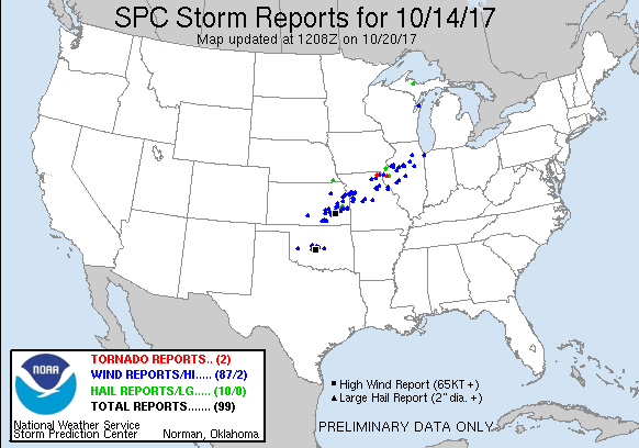 |
| Oct. 14 Severe Storm Reports (listing) |
PRELIMINARY LOCAL STORM REPORT...SUMMARY
NATIONAL WEATHER SERVICE CHICAGO/ROMEOVILLE IL
429 PM CDT MON OCT 16 2017

..TIME...   ...EVENT...      ...CITY LOCATION...     ...LAT.LON...
..DATE...   ....MAG....      ..COUNTY LOCATION..ST.. ...SOURCE....
            ..REMARKS..

0600 AM     HEAVY RAIN       SHABBONA                41.76N 88.88W
10/15/2017  M7.10 INCH       DE KALB            IL   TRAINED SPOTTER

0600 AM     HEAVY RAIN       3 SW MIDWAY AIRPORT     41.75N 87.79W
10/15/2017  M5.41 INCH       COOK               IL   CO-OP OBSERVER

            STORM TOTAL.

0600 AM     HEAVY RAIN       LAKEVIEW                41.94N 87.65W
10/15/2017  M6.30 INCH       COOK               IL   PUBLIC

            IN THE WRIGLEYVILLE NEIGHBORHOOD.

1130 PM     FLOOD            CHICAGO                 41.88N 87.63W
10/14/2017                   COOK               IL   EMERGENCY MNGR

            NUMEROUS INSTANCES OF FLOODING ON CITY ROADWAYS.

1130 PM     FLASH FLOOD      LOMBARD                 41.87N 88.01W
10/14/2017                   DUPAGE             IL   PUBLIC

            A PORTION OF NORTHBOUND FINLEY ROAD HAD AT LEAST 2 FEET
            OF WATER ON IT.

1115 PM     HEAVY RAIN       CAROL STREAM            41.92N 88.13W
10/14/2017  M4.42 INCH       DUPAGE             IL   PUBLIC

1115 PM     HEAVY RAIN       ELMHURST                41.90N 87.94W
10/14/2017  M5.98 INCH       DUPAGE             IL   BROADCAST MEDIA

            TOTAL RAINFALL AS OF 1115 PM SATURDAY EVENING. VIA WGN
            TV.

1030 PM     FLOOD            NAPERVILLE              41.76N 88.15W
10/14/2017                   DUPAGE             IL   LAW ENFORCEMENT

            NUMEROUS ROADS IN THE CITY FLOODED.

1030 PM     FLASH FLOOD      SOMONAUK                41.63N 88.68W
10/14/2017                   LA SALLE           IL   TRAINED SPOTTER

            2 FEET OF WATER ON U.S. HIGHWAY 34.

1015 PM     HEAVY RAIN       3 SW CHICAGO            41.85N 87.67W
10/14/2017  M6.30 INCH       COOK               IL   PUBLIC

            MEASURED IN THE MCKINLEY PARK NEIGHBORHOOD.

1015 PM     HEAVY RAIN       2 N JOLIET              41.56N 88.12W
10/14/2017  M3.50 INCH       WILL               IL   TRAINED SPOTTER

0930 PM     HEAVY RAIN       MORRIS                  41.37N 88.43W
10/14/2017  M2.50 INCH       GRUNDY             IL   EMERGENCY MNGR

            STORM TOTAL AT THE GRUNDY COUNTY EOC.

0918 PM     FLOOD            CRETE                   41.45N 87.62W
10/14/2017                   WILL               IL   AMATEUR RADIO

            5 INCHES OF WATER COVERING THE ROADWAY AT THE EDWARDS AND
            RONALD.

0917 PM     FLOOD            HAMMOND                 41.62N 87.49W
10/14/2017                   LAKE               IN   AMATEUR RADIO

            LEFT LANE OF I-80/94 EAST BOUND FLOODED IN CONSTRUCTION
            ZONE EAST BOUND MILE MARKER 3.5. REPORTED TO BE UP TO 9
            INCHES DEEP.

0903 PM     FLOOD            SCHERERVILLE            41.49N 87.45W
10/14/2017                   LAKE               IN   AMATEUR RADIO

            WATER ON RT-30 AND REED RD, AS WELL AS AT JOLIET AND REED
            RD.

0900 PM     HEAVY RAIN       2 NNW BURNHAM           41.66N 87.55W
10/14/2017  M3.10 INCH       COOK               IL   COCORAHS

            STORM TOTAL SO FAR.

0857 PM     TSTM WND DMG     SCHERERVILLE            41.49N 87.45W
10/14/2017                   LAKE               IN   TRAINED SPOTTER

            DELAYED REPORT. FENCES DOWN IN EAGLE RIDGE SUBDIVISION.
            METAL FLAGPOLE SNAPPED AT 77TH AVENUE AND ST. JOHN.
            STREET SIGNS BENT ALONG 77TH AVENUE. TREE DAMAGE NOTED
            SOUTHEAST TO JUST NORTH OF 85TH AVENUE ALONG AUSTIN
            AVENUE...WHICH IS APPROXIMATE END POINT OF A SWATH OF
            DAMAGE THAT STARTED ALONG 77TH AVENUE IN THE SOUTHEAST
            PORTION OF DYER.

0857 PM     TSTM WND DMG     SCHERERVILLE            41.49N 87.45W
10/14/2017                   LAKE               IN   AMATEUR RADIO

            POWER LINES DOWN AT 77TH AND AUSTIN AND AT 77TH AND ST
            JOHN. LARGE MAPLE TREE DOWNED. TIME ESTIMATED OFF OF
            RADAR.

0855 PM     TSTM WND DMG     1 SE DYER               41.49N 87.49W
10/14/2017                   LAKE               IN   TRAINED SPOTTER

            DELAYED REPORT. MULTIPLE 6 INCH OR MORE DIAMETER TREE
            LIMBS DOWNED AND 77TH AVENUE CLOSED DUE TO DOWNED POWER
            LINES. THIS IS THE START OF A SWATH OF WIND DAMAGE THAT
            WENT SOUTHEAST TO JUST NORTH OF 85TH AVENUE ALONG AUSTIN
            AVENUE IN SCHERERVILLE.

0845 PM     HEAVY RAIN       DEER PARK               42.17N 88.09W
10/14/2017  E0.00 INCH       LAKE               IL   EMERGENCY MNGR

            1 FOOT OF STANDING WATER ON LAKE-COOK ROAD AT DEER PARK
            BOULEVARD.

0840 PM     TSTM WND DMG     FAIRBURY                40.75N 88.51W
10/14/2017                   LIVINGSTON         IL   LAW ENFORCEMENT

            MULTIPLE LARGE LIMBS AND POWER LINES DOWNED. TIME
            ESTIMATED VIA RADAR.

0830 PM     HEAVY RAIN       5 NNW ADDISON           42.00N 88.05W
10/14/2017  M2.21 INCH       COOK               IL   COCORAHS

            STORM TOTAL SO FAR. THUNDERSTORMS WITH HEAVY RAINFALL.
            PEA SIZE HAIL. LOW AREA PONDING WITH RAPID RUNOFF.

0755 PM     FLOOD            HOFFMAN ESTATES         42.06N 88.14W
10/14/2017                   COOK               IL   TRAINED SPOTTER

            MULTIPLE SECTIONS OF ROADWAYS COVERED WITH WATER OF AT
            LEAST 3 INCHES IN DEPTH. NEAREST INTERSECTION HIGGINS AND
            GOLF.

0751 PM     TSTM WND GST     8 W STREATOR            41.13N 88.99W
10/14/2017  E50.00 MPH       LA SALLE           IL   TRAINED SPOTTER

            ALSO VISIBILITY AROUND 200 FEET DUE TO THE TORRENTIAL
            RAIN AND WIND COMBINATION.

0745 PM     TSTM WND DMG     STREATOR                41.13N 88.83W
10/14/2017                   LA SALLE           IL   LAW ENFORCEMENT

            UTILITY LINE BLOWN DOWN.

0740 PM     FLOOD            ST. CHARLES             41.92N 88.30W
10/14/2017                   KANE               IL   TRAINED SPOTTER

            REPORT OF MULTIPLE FLOODED ROADWAYS RELAYED VIA NWS QUAD
            CITIES.

0730 PM     TSTM WND DMG     NE NEWARK               41.54N 88.58W
10/14/2017                   KENDALL            IL   EMERGENCY MNGR

            TREES DOWN AND POWERPOLES SNAPPED IN SMALL LESS THAN 1000
            FOOT LONG PATH ALONG CHICAGO ROAD FROM NEAR COY PARK ROAD
            IN VICINITY OF NEWARK COMMUNITY HIGH SCHOOL NORTHEAST TO
            NEAR MEADOW LANE IN VICINITY OF NEWARK GRADE SCHOOL.
Photos
 |
 |
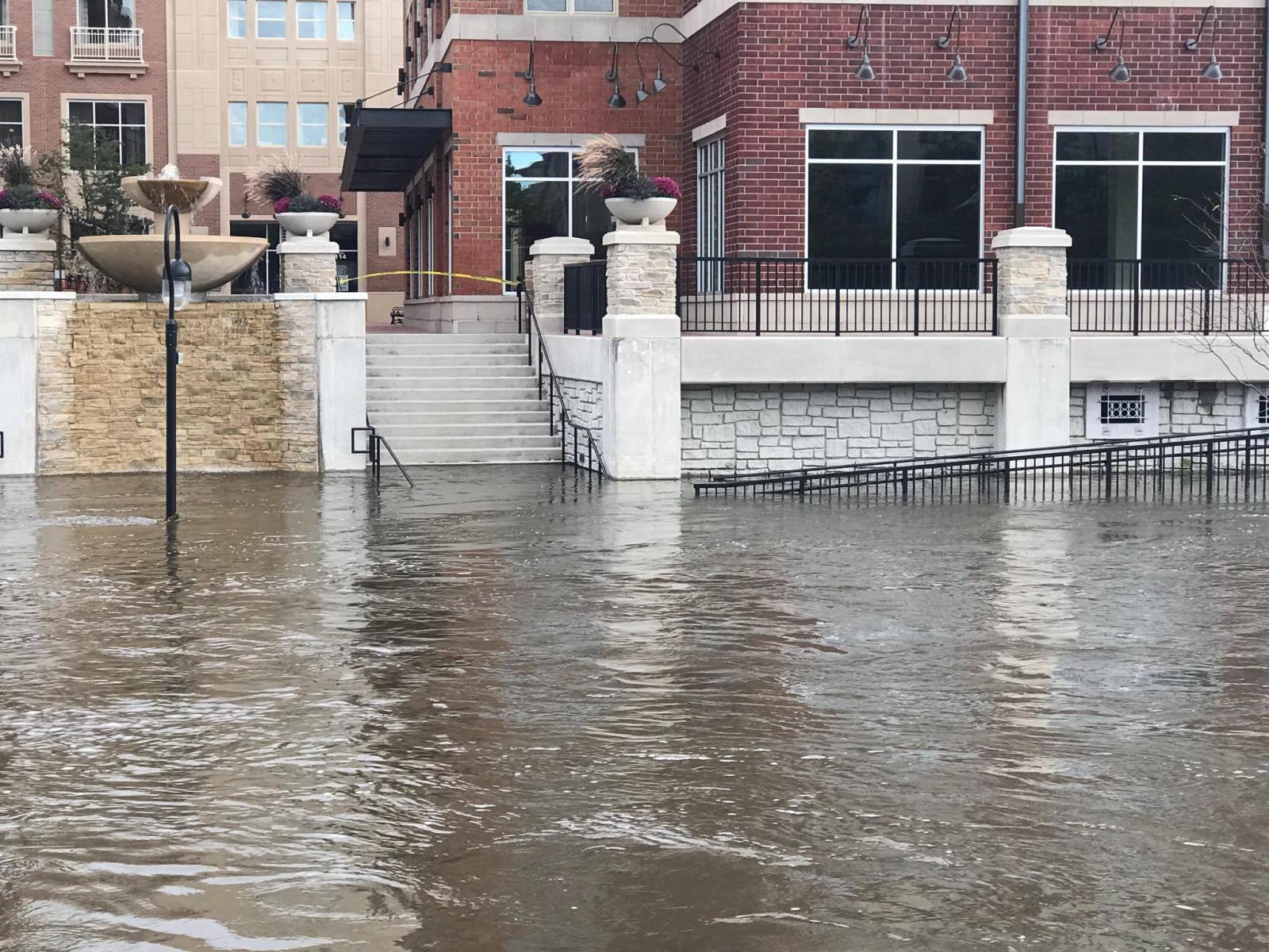 |
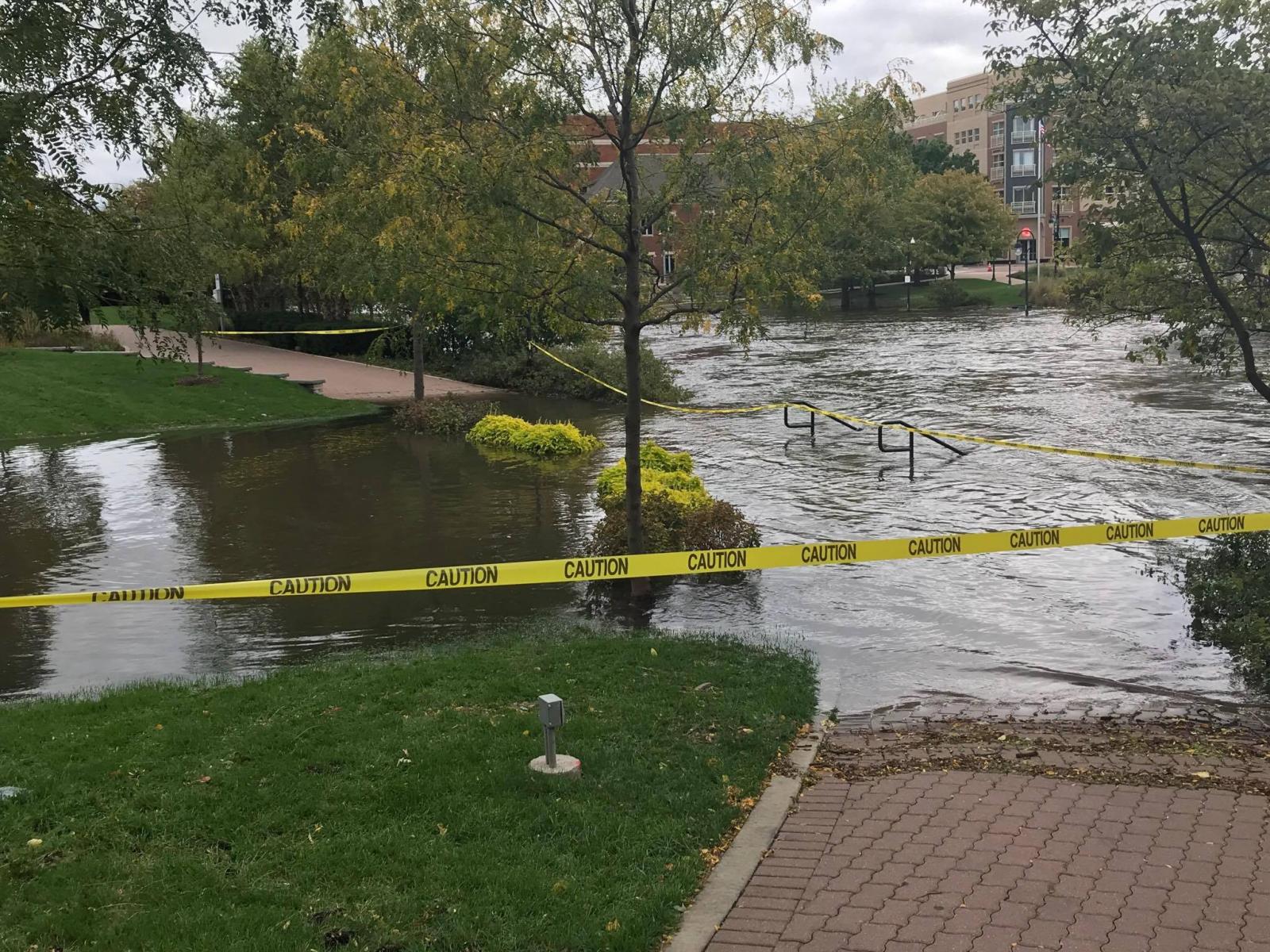
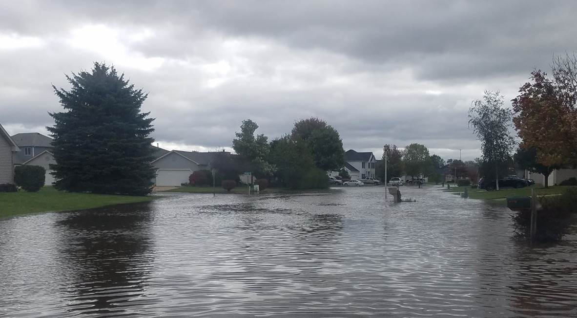
| DuPage River flooding in Naperville, IL (courtesy of Matt Piechota) | DuPage River flooding in Naperville, IL (courtesy of Matt Piechota) | DuPage River flooding in Naperville, IL (courtesy of Robert Skurski) |
 |
 |
 |
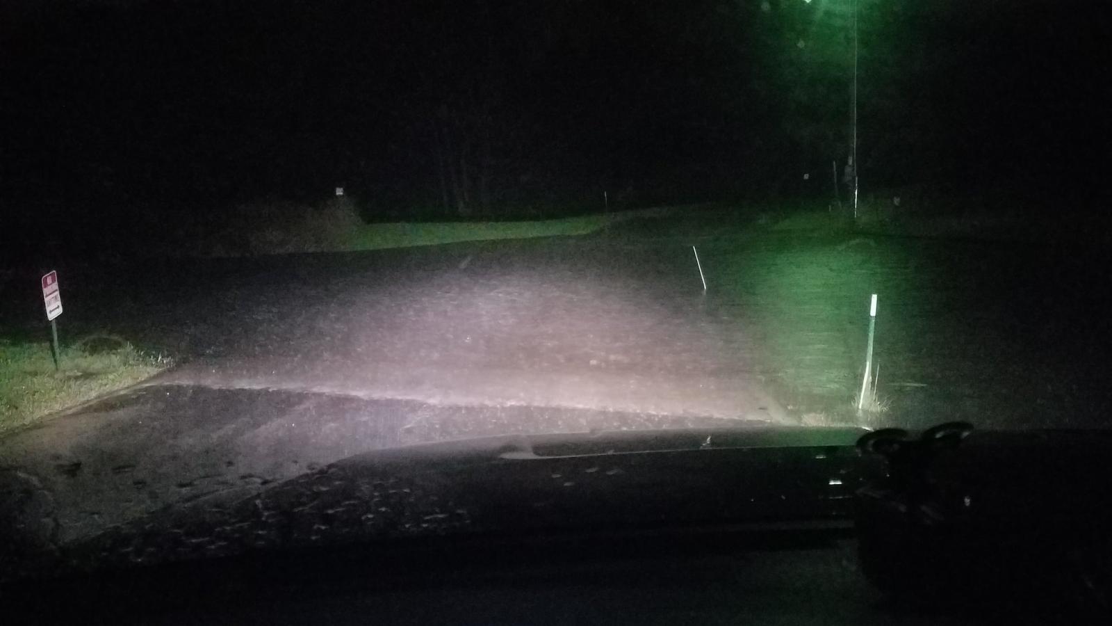
| Flash flooding outside of Somonauk, IL (courtesy of Bob Waszak) | Lake Holiday near Sandwich, IL (courtesy of Katie Witt) | Flooding outside in Sandwich, IL (courtesy of Bob Waszak) |
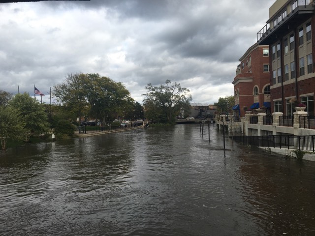
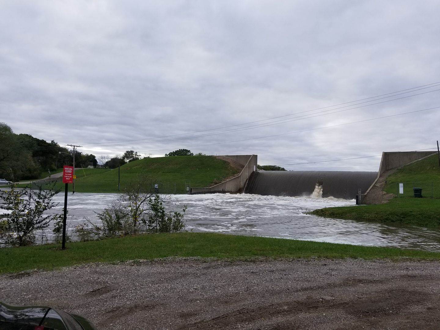
Rivers
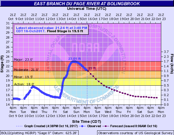
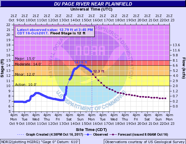
| DuPage River | ||
 |
 |
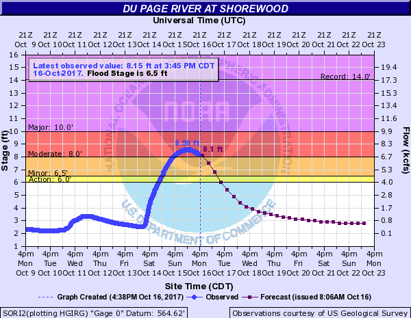 |
| Bolingbrook hydrograph | Plainfield hydrograph | Shorewood hydrograph |
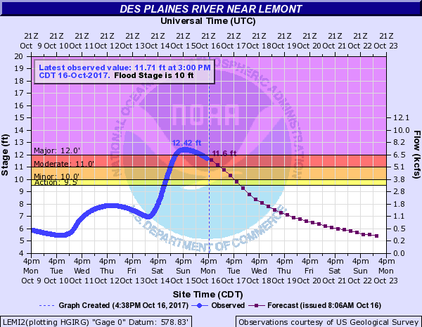
| Des Plaines River | North Branch of the Chicago River |
 |
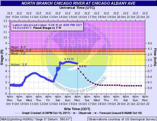 |
| Lemont hydrograph | Albany Avenue in Chicago hydrograph |
Meteorology & Radar
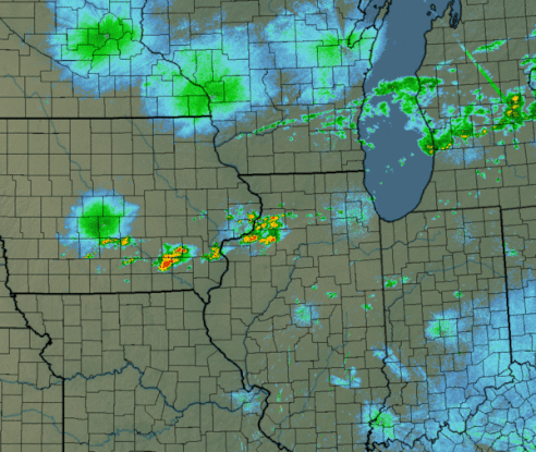 |
| 24-hour radar loop during Oct. 14, 2017 depicting around a half dozen separate waves of heavy-rain producing storms pass over northern Illinois (heaviest focused along U.S. Highway 34). Click here for a larger version. |
 |
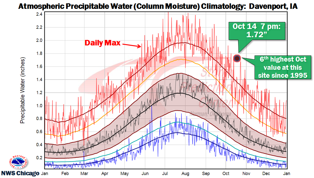 |
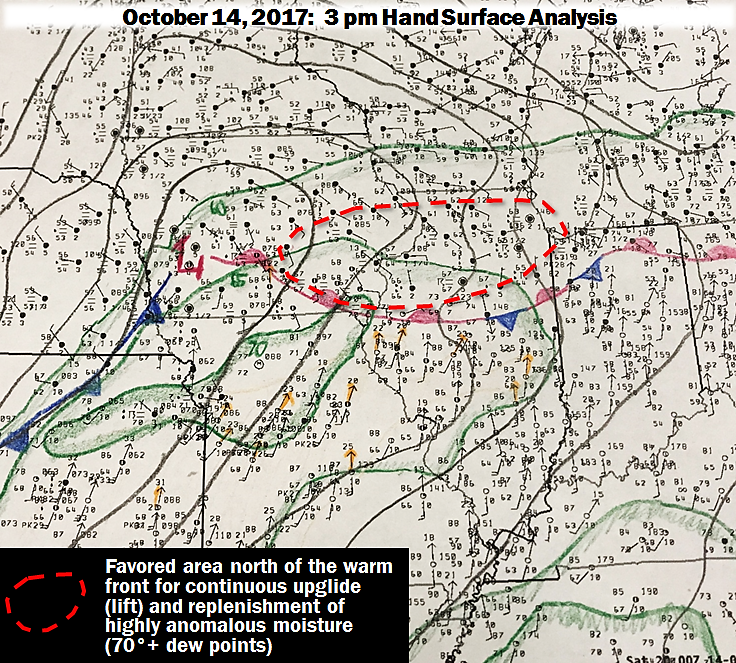
| Surface weather map | Precipitable water vs climatology as observed on the NWS Davenport, IA weather balloon launch at 7 pm on Oct. 14 |
Service
 |
 |
 |
 |
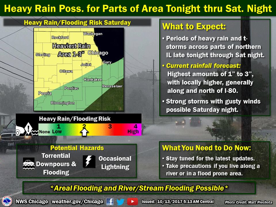
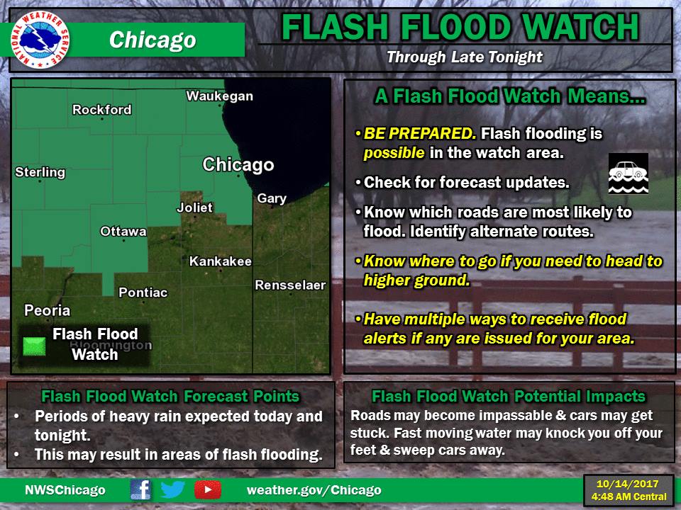
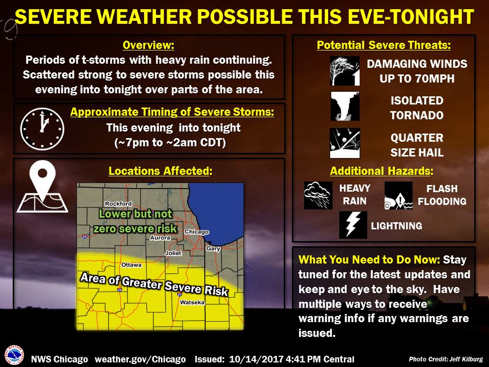
| Oct 13 5 am | Oct 14 5 am | Oct 14 5 pm | Oct 14 6 pm |
Additional
 |
Media use of NWS Web News Stories is encouraged! Please acknowledge the NWS as the source of any news information accessed from this site. Additional recaps can be found on the NWS Chicago Past Events Page |
|

