Overview
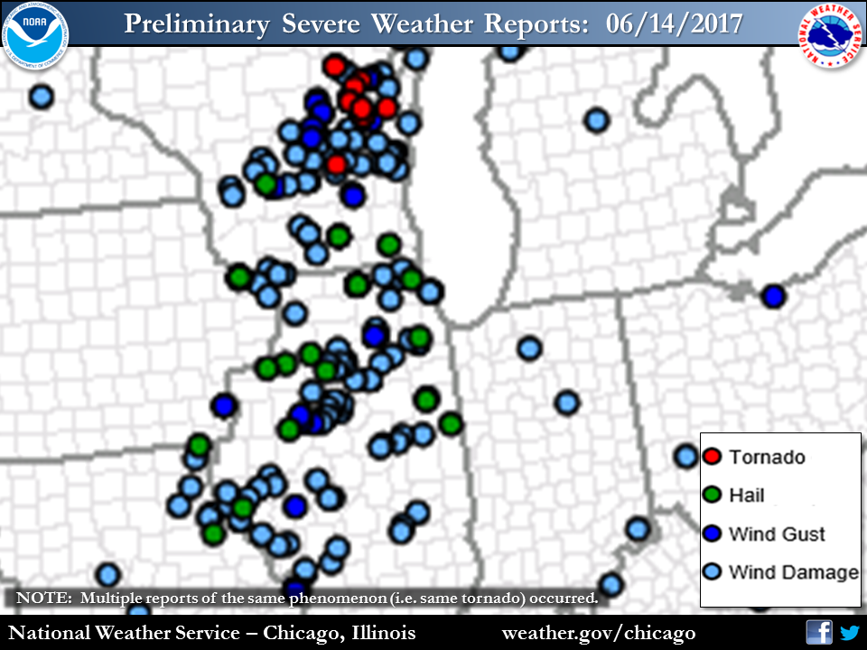
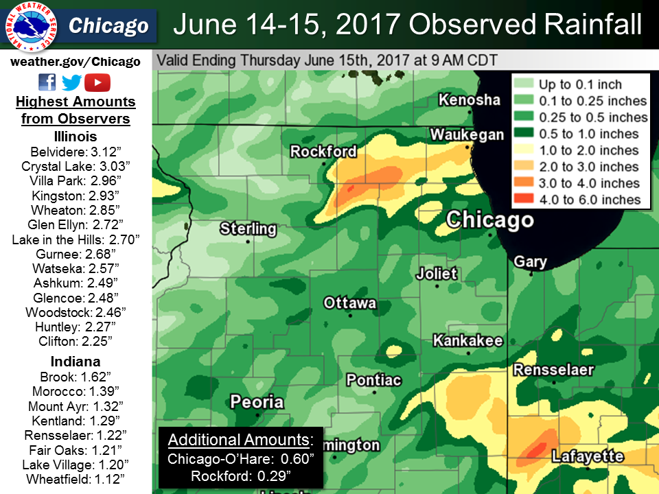
An area of more organized thunderstorms originated over the Missouri Valley and steadily tracked east through Iowa and Missouri during the morning of June 14th, reaching the I-39 corridor by around noon and then expanded in coverage as it steadily moved east across the area. Heavy rainfall of 2 to 5 inches fell over two separate areas, one over north central and northeast Illinois from eastern Rockford to portions of Lake County IL south to portions of the western Chicago suburbs, especially in central DuPage county. Another corridor of 2" to 5" rainfall amounts occurred from eastern Livingston and across Iroquois, Benton, Jasper and Newton counties. Areal Flood Warnings were issued for parts of these areas with reports of road closures and up to 2.5 feet of standing water. Large hail up to 1.5 inches and strong damaging winds were also associated with the storms, with numerous reports of extensive tree damage and downed power lines. The most extensive damage occurred primarily across LaSalle, Kendall, Grundy and DeKalb counties, where measured wind speeds as high as 72 mph occurred. A much more localized area of extensive damage occurred in Evanston and portions of adjacent Wilmette shortly after 5 pm. Here, a small-scale downburst was determined to have occurred based off radar assessment. These types of downbursts can sometimes be classified as microbursts depending on the size of the area impacted. In this localized damage, multiple large trees were uprooted, several of them falling on cars. Damage also occurred to the roof of Evanston Hospital. The severe thunderstorm activity diminished through the early evening hours.
Photos:
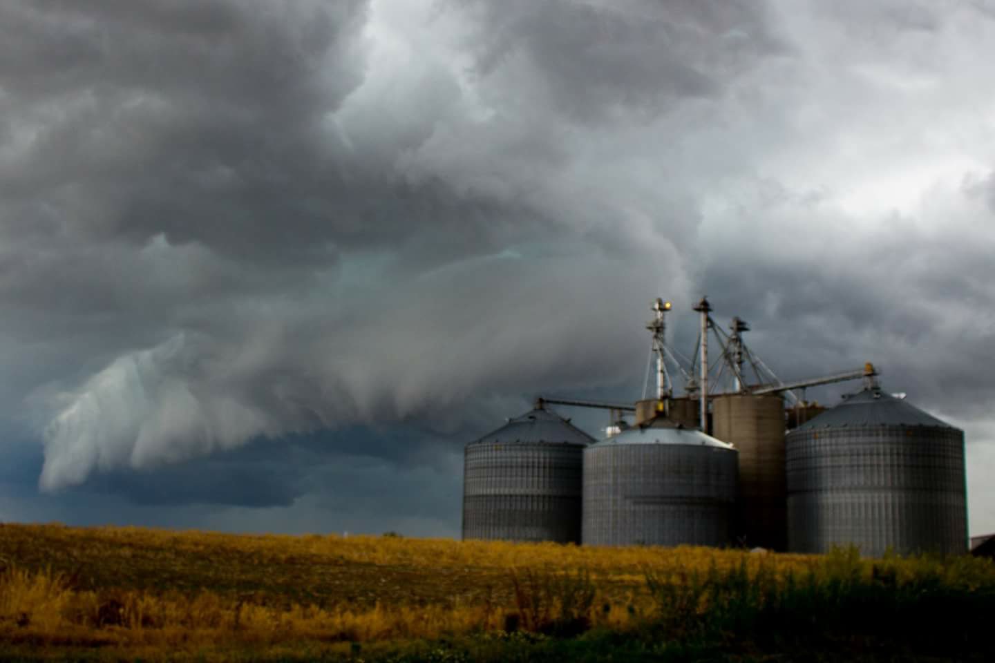
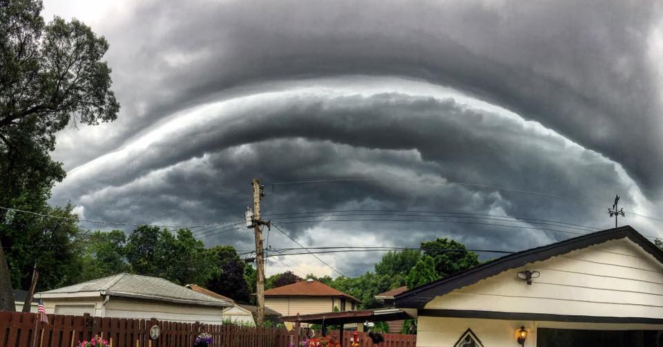
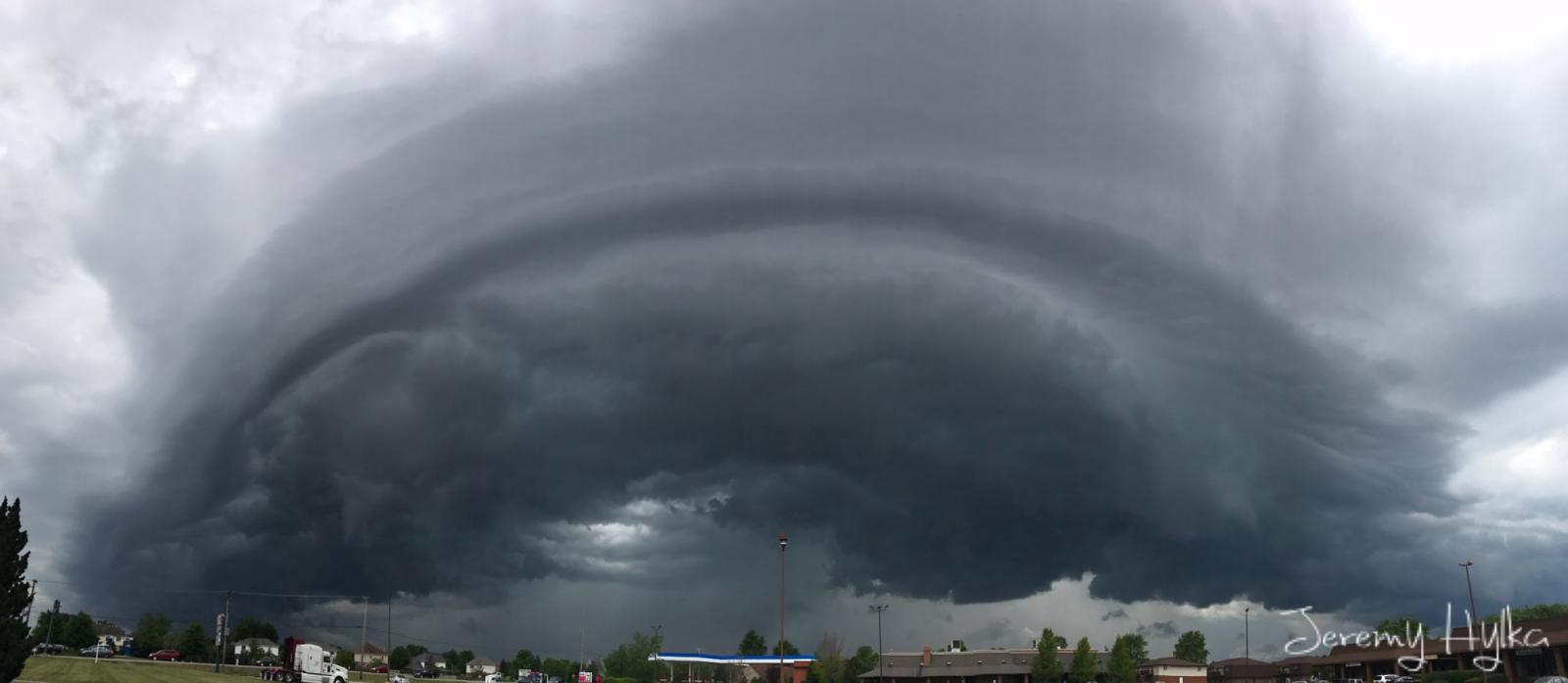
Clouds
 |
 |
 |
| Grant Park, IL (photo by Patrick Pahl) |
East Hazel Crest, IL (photo by Jenna Vance) |
Joliet, IL (photo by Jeremy Hylka) |
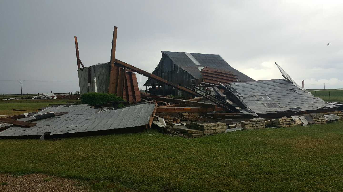
Damage
 |
 |
 |
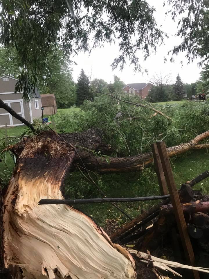
| Lostant, IL (photo by Jeff Wiggins) |
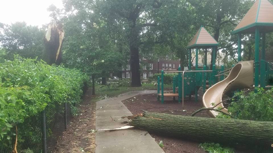
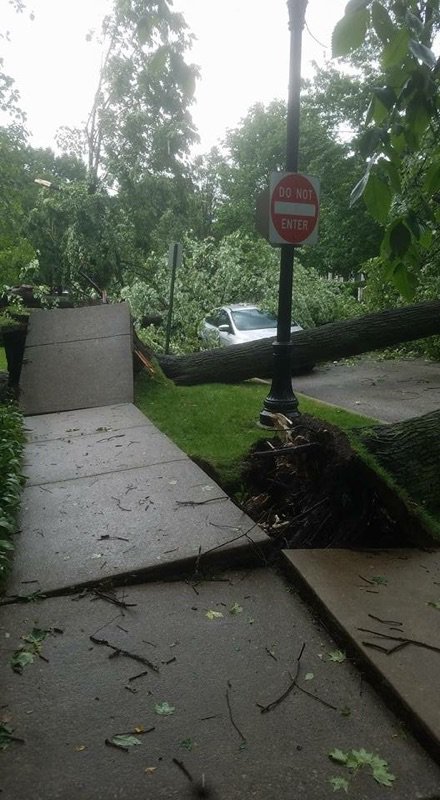
Evanston, IL (photo by Todd Shissler) |
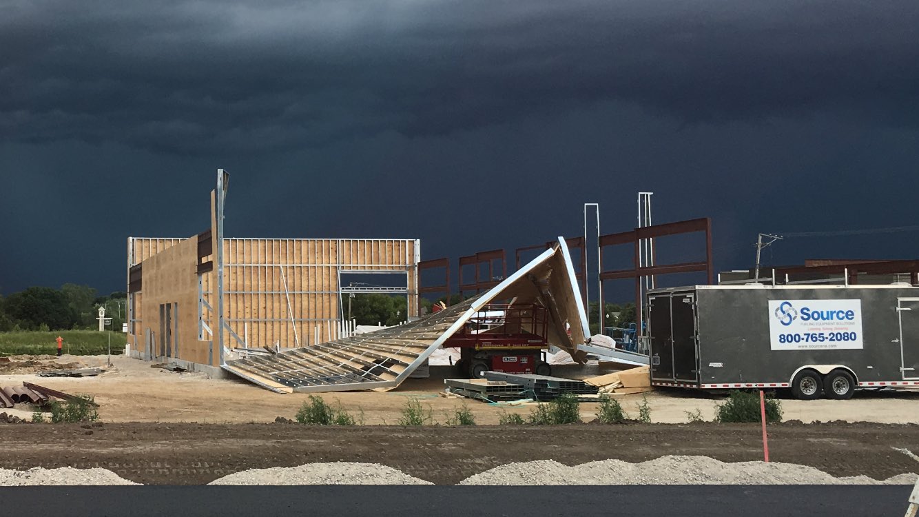
Elgin, IL (photo by Chuck Barham) |
 |
 |
 |
| Somonauk, IL (photo by Stephen Levick) |
Sandwich, IL (photo by Jet Alvarado) |
Evanston, IL (photo by Todd Shissler) |
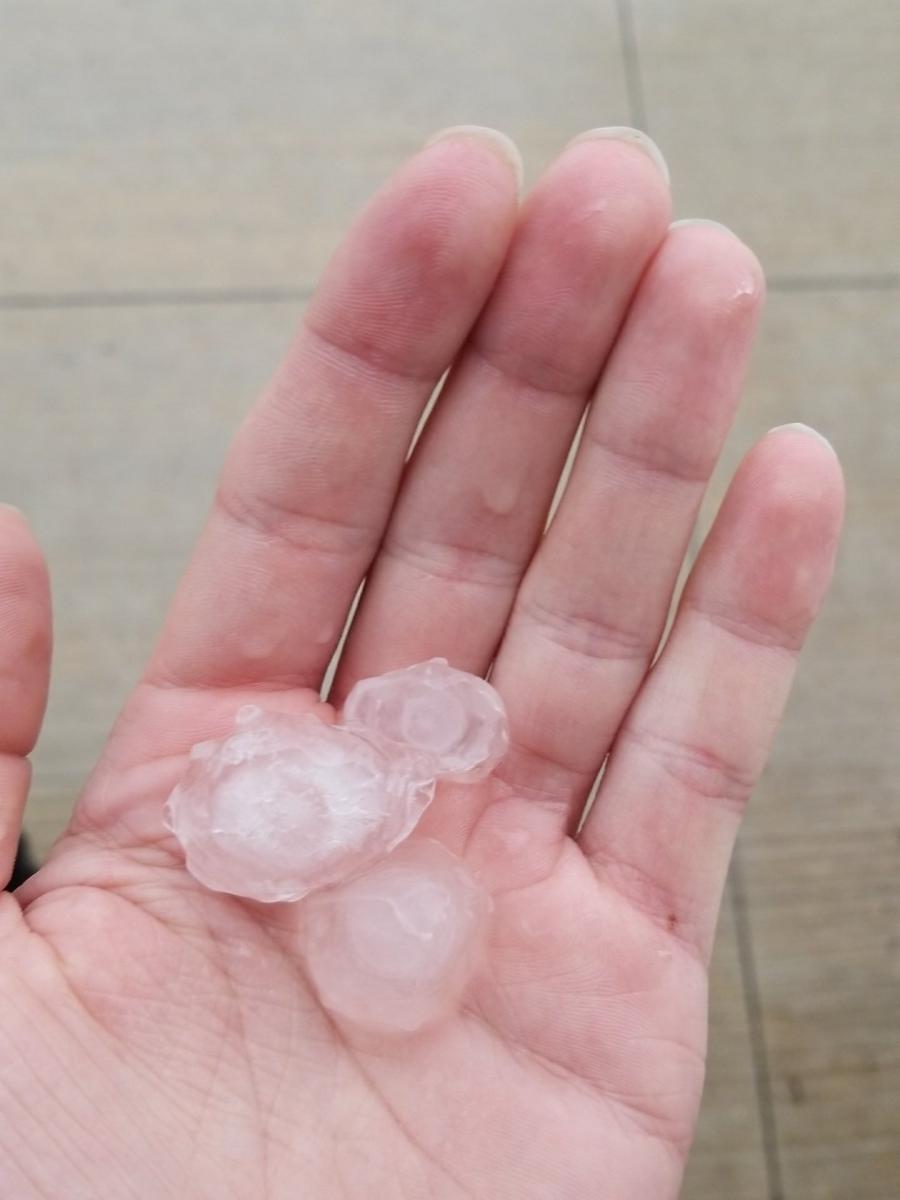
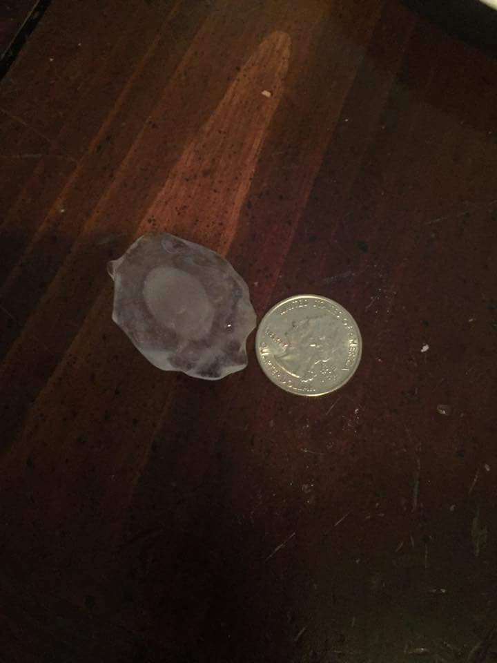
Hail
 |
 |
 |
| Belvidere, IL (photo by Lucas Reynolds) |
Waukegan Harbor (photo by James Wright) |
Belvidere, IL (photo by Breana Frewin) |
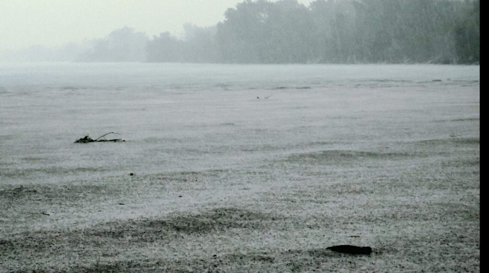
Radar:
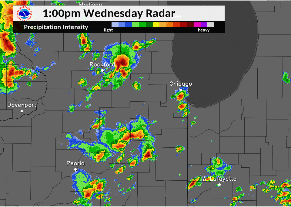 |
| Radar Loop from afternoon of June 14, 2017 |
Storm Reports
PRELIMINARY LOCAL STORM REPORT...SUMMARY
NATIONAL WEATHER SERVICE CHICAGO/ROMEOVILLE IL
302 PM CDT THU JUN 15 2017
..TIME... ...EVENT... ...CITY LOCATION... ...LAT.LON...
..DATE... ....MAG.... ..COUNTY LOCATION..ST.. ...SOURCE....
..REMARKS..
1229 PM HAIL 2 SW BELVIDERE 42.24N 88.87W
06/14/2017 E0.75 INCH BOONE IL PUBLIC
DIME SIZE HAIL AT CHRYSLER PLANT
1233 PM HAIL 1 NNE BELVIDERE 42.26N 88.84W
06/14/2017 E1.00 INCH BOONE IL TRAINED SPOTTER
1250 PM HAIL 1 NNE BELVIDERE 42.26N 88.84W
06/14/2017 E1.00 INCH BOONE IL TRAINED SPOTTER
1252 PM HAIL 1 NNW BELVIDERE 42.27N 88.85W
06/14/2017 E1.00 INCH BOONE IL PUBLIC
QUARTER SIZE HAIL NEAR STATE ST.
0100 PM HAIL NW BELVIDERE 42.26N 88.86W
06/14/2017 E1.00 INCH BOONE IL PUBLIC
1 INCH HAIL REPORTED NEAR THE WILLIAM GRADY POOL.
0101 PM HAIL 1 NE BELVIDERE 42.26N 88.84W
06/14/2017 E1.00 INCH BOONE IL PUBLIC
1 INCH HAIL REPORTED NEAR NORTH STATE STREET.
0103 PM HAIL 1 NNE BELVIDERE 42.26N 88.84W
06/14/2017 E1.25 INCH BOONE IL BROADCAST MEDIA
NEAR STATE ST.
0107 PM FLOOD 1 NW BELVIDERE 42.26N 88.86W
06/14/2017 BOONE IL LAW ENFORCEMENT
OFFICER REPORTED ABOUT 1 FOOT OF WATER AT GARDEN DRIVE
AND RUBY STREET.
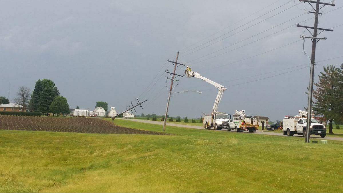
0145 PM TSTM WND DMG 4 SW WONDER LAKE 42.33N 88.41W
06/14/2017 MCHENRY IL EMERGENCY MNGR
MULTIPLE TREES DOWN NEAR WOODSTOCK AND WONDER LAKE. TREE
BLOCKING ROAD AT BANFORD AND QUEEN ANNE IN WOODSTOCK AND
ON THOMPSON NORTH OF ROUTE 120 IN WONDER LAKE.
0156 PM HAIL WOODSTOCK 42.31N 88.44W
06/14/2017 E0.75 INCH MCHENRY IL TRAINED SPOTTER
DIME SIZED HAIL REPORTED A HALF MILE SOUTH OF ROUTE 14,
ON DEAN STREET.
0245 PM HAIL 1 SE GAGES LAKE 42.34N 87.96W
06/14/2017 E0.75 INCH LAKE IL TRAINED SPOTTER
DIME SIZE HAIL ALONG WITH TORRENTIAL RAINFALL AND
40-50MPH WIND GUSTS AT RT. 120 AND HUNT CLUB RD.
0254 PM TSTM WND DMG 5 SE FOX LAKE 42.37N 88.10W
06/14/2017 LAKE IL FIRE DEPT/RESCUE
REPORTS OF POWER LINES DOWN BEHIND MR. TS LIQUORS , 812
W. ROLLINS RD.
0255 PM TSTM WND DMG 4 NNE GILMAN 40.82N 87.98W
06/14/2017 IROQUOIS IL PUBLIC
LARGE TREE SNAPPED
0255 PM HAIL 1 N GILMAN 40.79N 88.00W
06/14/2017 E1.00 INCH IROQUOIS IL EMERGENCY MNGR
0300 PM TSTM WND DMG 4 E ISLAND LAKE 42.27N 88.13W
06/14/2017 LAKE IL EMERGENCY MNGR
TREE AND WIRES DOWN NEAR BONNER RD. AND MADISON AVE.
0307 PM HAIL 5 N BUFFALO GROVE 42.24N 87.97W
06/14/2017 E1.00 INCH LAKE IL PUBLIC
0327 PM TSTM WND GST 6 WNW PLEASANT RIDGE 40.96N 87.18W
06/14/2017 E55.00 MPH JASPER IN PUBLIC
ESTIMATED WIND GUSTS AROUND 55 MPH. 2 INCH DIAMETER TREE
BRANCHES BLOWN DOWN.
0335 PM TSTM WND GST 6 W PLEASANT RIDGE 40.94N 87.18W
06/14/2017 M48.00 MPH JASPER IN ASOS
RENSSELAER AIRPORT KRZL
0335 PM HEAVY RAIN CRYSTAL LAKE 42.23N 88.33W
06/14/2017 E3.43 INCH MCHENRY IL CO-OP OBSERVER
STORM TOTAL SINCE 7 AM.
0348 PM FLOOD 4 SSW BEACH PARK 42.37N 87.90W
06/14/2017 LAKE IL PUBLIC
MINOR FLOODING
0400 PM TSTM WND DMG 1 NNW EVANSTON 42.06N 87.71W
06/14/2017 COOK IL PUBLIC
SEVERAL LARGE TREES BLOWN OVER AROUND HARRISON ST NEAR
ACKERMAN PARK, SOUTH OF CENTRAL ST.
0405 PM FLOOD 5 NNW ALGONQUIN 42.23N 88.33W
06/14/2017 MCHENRY IL PUBLIC
ESTIMATED 5 INCHES OF STANDING WATER ON US-14 AND KEITH
AVE. IN CRYSTAL LAKE
0415 PM TSTM WND GST 3 WNW LA SALLE 41.35N 89.15W
06/14/2017 M48.00 MPH LA SALLE IL ASOS
PERU AIRPORT KVYS
0415 PM TSTM WND GST 2 SSW ROCHELLE 41.89N 89.08W
06/14/2017 M46.00 MPH OGLE IL ASOS
ROCHELLE AIRPORT KRPJ
0417 PM FLOOD 5 NNW KINGSTON 42.17N 88.78W
06/14/2017 BOONE IL PUBLIC
ESTIMATED 4 INCHES OF STANDING WATER ON DAVIS SCHOOL RD.
AND GLIDDEN RD.
0418 PM TSTM WND GST W SUGAR GROVE 41.77N 88.47W
06/14/2017 M49.00 MPH KANE IL ASOS
SUGAR GROVE - AURORA AIRPORT KARR
0424 PM TSTM WND DMG 5 S TONICA 41.14N 89.07W
06/14/2017 LA SALLE IL TRAINED SPOTTER
2 BARNS DESTROYED
0430 PM TSTM WND DMG SSW STREATOR 41.12N 88.83W
06/14/2017 LA SALLE IL FIRE DEPT/RESCUE
STREATOR FIRE DEPARTMENT REPORTING STRONG STRAIGHT LINE
WINDS CAUSING OVER 30 REPORTS OF TREES DOWN.
0430 PM TSTM WND DMG SSW STREATOR 41.12N 88.84W
06/14/2017 LA SALLE IL EMERGENCY MNGR
TIME ESTIMATED. 60MPH WINDS AND MULTIPLE LARGE TREES DOWN
0430 PM FLOOD CRYSTAL LAKE 42.23N 88.33W
06/14/2017 MCHENRY IL EMERGENCY MNGR
DELAYED REPORT. SEVERAL ROADS OVERTOPPED BY ABOUT 3 TO 4
INCHES OF WATER...WITH A FEW ROADS CLOSED. TIME
ESTIMATED.
0434 PM TSTM WND DMG 3 W LITTLE ROCK 41.71N 88.64W
06/14/2017 DE KALB IL PUBLIC
REPORT OF POWER LINES DOWN AND SEVERAL POLES BLOW OVER
ALONG E CHICAGO RD NEAR SANDWICH, IL
0434 PM TSTM WND DMG 3 SW SANDWICH 41.62N 88.66W
06/14/2017 LA SALLE IL PUBLIC
SEVERAL REPORTS OF TREE DAMAGE ACROSS THE SANDWICH/LAKE
HOLIDAY AREA
0439 PM TSTM WND DMG 1 W SENECA 41.30N 88.63W
06/14/2017 LA SALLE IL TRAINED SPOTTER
SEMI BLOWN OVER 1 WEST OF SENECA EXIT ON I-80
0440 PM TSTM WND DMG 1 WSW STREATOR 41.12N 88.84W
06/14/2017 LA SALLE IL TRAINED SPOTTER
40 TO 50 FOOT TALL OAK TREE UPROOTED
0445 PM TSTM WND DMG MORRIS 41.37N 88.43W
06/14/2017 GRUNDY IL NEWSPAPER
2 BLOCK AREA IN MORRIS WITH WIDESPREAD TREE DAMAGE, TREES
BLOWN DOWN, AND SHINGLES OFF ROOFS. DELAYED REPORT,
ESTIMATED TIME WAS 445 PM.
0450 PM TSTM WND DMG 1 SSW SANDWICH 41.63N 88.63W
06/14/2017 DE KALB IL EMERGENCY MNGR
MANY POWER LINES DOWN AS WELL AS TREE DAMAGE
0450 PM FLOOD 5 WSW ISLAND LAKE 42.25N 88.30W
06/14/2017 MCHENRY IL PUBLIC
ESTIMATED 2-2.5 FEET OF STANDING WATER NEAR 176 AND TERRA
COTTA IN CRYSTAL LAKE
0453 PM TSTM WND GST 3 WSW SANDWICH 41.63N 88.68W
06/14/2017 M72.00 MPH LA SALLE IL TRAINED SPOTTER
72MPH WIND GUST ACCOMPANIED BY NICKEL SIZE HAIL
0455 PM HEAVY RAIN 4 SSW BEACH PARK 42.37N 87.89W
06/14/2017 M1.94 INCH LAKE IL TRAINED SPOTTER
MEASURED IN THE LAST HOUR AND 45 MINUTES
0455 PM TSTM WND DMG 3 WSW SANDWICH 41.63N 88.68W
06/14/2017 DE KALB IL TRAINED SPOTTER
MULTIPLE TREES DOWN ON HOMES
0501 PM TSTM WND DMG 5 SW GIBSON CITY 40.41N 88.45W
06/14/2017 FORD IL STORM CHASER
DELAYED REPORT. A LARGE SECTION OF A TREE SNAPPED OFF AND
BLOWN ACROSS THE ROAD. REPORT RELAYED VIA FACEBOOK. TIME
ESTIMATED BY RADAR.
0505 PM TSTM WND DMG 1 NNE EVANSTON 42.07N 87.68W
06/14/2017 COOK IL PUBLIC
ROOF DAMAGE TO EVANSTON HOSPITAL.
0505 PM TSTM WND GST 1 N EVANSTON 42.06N 87.70W
06/14/2017 M57.00 MPH COOK IL BROADCAST MEDIA
57 MPH WIND GUST MEASURED
0505 PM TSTM WND DMG W JOLIET 41.53N 88.12W
06/14/2017 WILL IL PUBLIC
SMALL MAPLE TREE DOWN ON THE WEST SIDE OF JOLIET.
0508 PM TSTM WND DMG EVANSTON 42.05N 87.69W
06/14/2017 COOK IL PUBLIC
SEVERAL REPORTS OF WIND DAMAGE TO TREES ACROSS THE
EVANSTON AND WILMETTE AREA
0508 PM HEAVY RAIN 2 SW ADDISON 41.90N 88.04W
06/14/2017 M2.25 INCH DUPAGE IL PUBLIC
0509 PM TSTM WND DMG 2 W SANDWICH 41.65N 88.66W
06/14/2017 DE KALB IL PUBLIC
TRAMPOLINE THROWN OVER GARAGE AND TWO FENCES DESTROYED
0512 PM TSTM WND DMG 4 SSE INGALLS PARK 41.47N 88.00W
06/14/2017 WILL IL TRAINED SPOTTER
TREE BRANCH 7 INCHES IN DIAMETER DOWN AT 24 DANIEL LEWIS
DR.
0513 PM TSTM WND GST SSE PLAINFIELD 41.61N 88.20W
06/14/2017 M51.00 MPH WILL IL EMERGENCY MNGR
0517 PM HEAVY RAIN 1 WNW CHERRY VALLEY 42.25N 88.98W
06/14/2017 M1.37 INCH WINNEBAGO IL COCORAHS
.74 INCHES MEASURED IN 20 MINUTES WITH A STORM TOTAL SO
FAR OF 1.37 INCHES. BRIEF PENNY SIZE HAIL AND WIND SPEEDS
AROUND 35MPH OBSERVED
0520 PM HAIL 4 ENE INGALLS PARK 41.54N 87.97W
06/14/2017 E1.00 INCH WILL IL PUBLIC
0533 PM TSTM WND DMG 3 W ELGIN 42.04N 88.35W
06/14/2017 KANE IL PUBLIC
DELAYED REPORT. A PORTION OF A NEW GAS STATION UNDER
CONSTRUCTION BLOWN DOWN. INTERSECTION OF ROUTE 20 AND
NESLER ROAD. REPORT RELAYED VIA SOCIAL MEDIA. TIME
ESTIMATED BY RADAR.
0553 PM HEAVY RAIN 1 WNW CHERRY VALLEY 42.25N 88.98W
06/14/2017 M1.70 INCH WINNEBAGO IL TRAINED SPOTTER
STORM TOTAL RAINFALL SO FAR.
0600 PM HEAVY RAIN 1 N CROWN POINT 41.44N 87.36W
06/14/2017 M0.90 INCH LAKE IN CO-OP OBSERVER
0619 PM TSTM WND GST 2 W WHEATFIELD 41.19N 87.09W
06/14/2017 E0.00 MPH JASPER IN TRAINED SPOTTER
ESTIMATED WIND GUST OF 50-60 MPH
0620 PM MARINE TSTM WIND 5 SSE BEACH PARK 42.36N 87.81W
06/14/2017 M50.00 MPH LAKE IL C-MAN STATION
0642 PM FLOOD 5 SSW ADDISON 41.86N 88.05W
06/14/2017 DUPAGE IL PUBLIC
MINOR FLOODING ON ROADWAY AROUND 53 AND ROOSEVELT RD WITH
ADDITIONAL FLOODING OF SEVERAL ROADS IN AND AROUND
WHEATON.
0700 AM HEAVY RAIN 1 S DWIGHT 41.08N 88.42W
06/15/2017 M2.00 INCH LIVINGSTON IL PUBLIC
STORM TOTAL RAINFALL FROM WEDNESDAY JUNE 14TH RELAYED BY
BROADCAST MEDIA.
0700 AM HEAVY RAIN CULLOM 40.88N 88.27W
06/15/2017 M2.60 INCH LIVINGSTON IL PUBLIC
STORM TOTAL RAINFALL FROM WEDNESDAY JUNE 14TH. REPORT
RELAYED BY BROADCAST MEDIA.
0700 AM HEAVY RAIN EMINGTON 40.97N 88.36W
06/15/2017 M2.50 INCH LIVINGSTON IL PUBLIC
STORM TOTAL RAINFALL REPORT FROM WEDNESDAY JUNE 14TH
RELAYED BY BROADCAST MEDIA.
&&
$$
RC
Rain Reports
Public Information Statement
National Weather Service Chicago IL
1030 AM CDT Thu Jun 15 2017

...Morning Rainfall Roundup...

   The following are rain amounts for the previous 24-hours
   as measured in the morning by NWS Cooperative Observers
   and CoCoRaHS observers.
   Observations are usually taken between 6 AND 8 AM.

   24-hour rainfall amounts
       for Thursday(06/15/17)...


Illinois                                       Rain
  Location (County):                           fall (inches)

  Belvidere 2NW (Boone)........................3.12
  Crystal Lake 1WSW (McHenry)..................3.03
  Villa Park 1NW (Du Page).....................2.96
  Kingston 2WNW (De Kalb)......................2.93
  Wheaton 2NNE (Du Page).......................2.85
  Glen Ellyn 1WSW (Du Page)....................2.72
  Lake in the Hills 2.5W (McHenry).............2.70
  Gurnee 2W (Lake).............................2.68
  Crystal Lake 5ENE (McHenry)..................2.68
  Watseka (Iroquois)...........................2.57
  Ashkum 5.6E (Iroquois).......................2.49
  Botanic Gardens (Cook).......................2.48
  Woodstock 4SW (McHenry)......................2.46
  Belvidere (Boone)............................2.40
  Huntley (McHenry)............................2.27
  Clifton 1NW (Iroquois).......................2.25
  Mchenry (McHenry)............................2.24
  Gilberts (Kane)..............................2.19
  Genoa (De Kalb)..............................2.12
  Waukegan 2E (Lake)...........................2.11
  Dwight 4NNW (Grundy).........................2.09
  Lake Forest 2NNE (Lake)......................2.02
  Park Ridge (Cook)............................2.00
  Glencoe (Cook)...............................1.98
  Lombard 1WSW (Du Page).......................1.94
  Bull Valley 2WNW (McHenry)...................1.94
  Streamwood (Cook)............................1.88
  Elmhurst 1ESE (Du Page)......................1.80
  Lombard 1NNW (Du Page).......................1.75
  Mundelein 2WNW (Lake)........................1.74
  Elmhurst (Du Page)...........................1.70
  Mundelein (Lake).............................1.70
  Wheeling (Cook)..............................1.69
  Carpentersville 1E (Kane)....................1.67
  Lake In The Hills 1ESE (McHenry).............1.66
  Woodstock 5nw (McHenry)......................1.63
  Lake Bluff 1W (Lake).........................1.60
  Wonder Lake 1WNW (McHenry)...................1.60
  Chebanse (Kankakee)..........................1.58
  Lincolnshire 1N (Lake).......................1.58
  Highwood 1S (Lake)...........................1.49
  Oak Park 2S (Cook)...........................1.45
  Oak Park 1NNE (Cook).........................1.45
  Mundelein (Lake).............................1.42
  St Anne (Kankakee)...........................1.42
  Fox Lake 2SE (Lake)..........................1.40
  West Chicago (Du Page).......................1.38
  Lincolnwood 2E (Cook)........................1.37
  Elmhurst 2SE (Du Page).......................1.37
  Schaumburg 2E (Cook).........................1.36
  Bannockburn (Lake)...........................1.35
  Lakemoor 2SE (Lake)..........................1.31
  Elk Grove Village 2WSW (Cook)................1.30
  Somonauk 2NE (De Kalb).......................1.30
  Harwood Heights (Cook).......................1.29
  Chicago 6ESE (Cook)..........................1.28
  Elgin 2WNW (Kane)............................1.28
  Wadsworth 1SSE (Lake)........................1.28
  Lily Lake 2E (Kane)..........................1.26
  Harvard 3SSE (McHenry).......................1.26
  Wonder Lake 1NE (McHenry)....................1.26
  Harvard (McHenry)............................1.25
  Carol Stream (Du Page).......................1.24
  Park Ridge 1WNW (Cook).......................1.23
  River Forest 1SSE (Cook).....................1.23
  Lake Zurich 1N (Lake)........................1.22
  Lake Zurich (Lake)...........................1.22
  Chatsworth (Livingston)......................1.20
  Dwight (Livingston)..........................1.20
  Hebron (McHenry).............................1.20
  Chatsworth (Livingston)......................1.20
  St. Charles (Kane)...........................1.19
  Waukegan (Lake)..............................1.19
  Chicago 6NNE (Cook)..........................1.18
  Algonquin 1N (McHenry).......................1.16
  Oak Park 1SW (Cook)..........................1.14
  Cary (McHenry)...............................1.12
  Lakemoor 2NW (McHenry).......................1.11
  Lake Villa 2WSW (Lake).......................1.10
  La Grange Park 1SSW (Cook)...................1.07
  Barrington (Lake)............................1.06
  Bridgeview 1NNW (Cook).......................1.06
  Elburn (Kane)................................1.05
  Glen Ellyn (Du Page).........................1.05
  Elburn (Kane)................................1.05
  Midway (Cook)................................1.05
  Marseilles (La Salle)........................1.05
  Elgin (Kane).................................1.04
  Elgin 1S (Kane)..............................1.04
  Elk Grove Village 1ESE (Cook)................1.03
  Lisle 1SE (Du Page)..........................1.02
  Downers Grove 0.4NNE (Du Page)...............1.01
  Ravenswood Manor (Cook)......................0.99
  Cary (McHenry)...............................0.95
  St. Charles 6NW (Kane).......................0.94
  Buffalo Grove 2N (Lake)......................0.94
  Riverwoods (Lake)............................0.94
  Lake Villa 1SSW (Lake).......................0.92
  Emington 2SSE (Livingston)...................0.91
  Arlington Heights 1SW (Cook).................0.90
  Elgin 8WSW (Kane)............................0.89
  Lincolnshire 1.3WSW (Lake)...................0.89
  Lincolnwood 3E (Cook)........................0.86
  Naperville 2ESE (Du Page)....................0.86
  Morris 5NNW (Grundy).........................0.86
  Elgin 2NE (Kane).............................0.86
  Elgin (Kane).................................0.85
  Arlington Heights 3SSW (Cook)................0.83
  Buckley (Iroquois)...........................0.82
  Winnetka 1ESE (Cook).........................0.79
  Gibson 3WNW (Ford)...........................0.79
  Hoffman Estates 5W (Cook)....................0.76
  Aurora 4NE (Du Page).........................0.76
  Somonauk (De Kalb)...........................0.74
  Aurora (Kane)................................0.73
  Palatine 1NNE (Cook).........................0.73
  Geneva 1SSW (Kane)...........................0.72
  Morris (Grundy)..............................0.72
  North Aurora 2NE (Kane)......................0.71
  Ottawa 2N (La Salle).........................0.71
  Lisle (Du Page)..............................0.70
  North Utica 6N (La Salle)....................0.69
  Batavia 1WSW (Kane)..........................0.68
  Cissna Park 1S (Iroquois)....................0.63
  Batavia 2WNW (Kane)..........................0.63
  Momence 6SSW (Kankakee)......................0.62
  Midlothian (Cook)............................0.61
  New Lenox 3E (Will)..........................0.61
  Capron (Boone)...............................0.60
  Midlothian (Cook)............................0.60
  Morris 2N (Grundy)...........................0.60
  Wilmington 6NW (Will)........................0.60
  Ohare (Cook).................................0.60
  Batavia (Kane)...............................0.59
  Herscher 3E (Kankakee).......................0.58
  Zion (Lake)..................................0.58
  Willow Springs (Cook)........................0.57
  Mendota (La Salle)...........................0.56
  Alsip (Cook).................................0.55
  Midlothian (Cook)............................0.55
  Mokena 1W (Will).............................0.55
  Gibson 6NE (Ford)............................0.54
  Sheridan 3SSE (La Salle).....................0.54
  Lansing (Cook)...............................0.54
  Seneca 2SSW (La Salle).......................0.52
  Mazon 0.5ENE (Grundy)........................0.51
  Seneca 1NNE (La Salle).......................0.51
  Westmont (Du Page)...........................0.51
  Amboy (Lee)..................................0.50
  Mendota (La Salle)...........................0.50
  Peru (La Salle)..............................0.50
  Peru 1SW (La Salle)..........................0.48
  Oak Lawn 2SE (Cook)..........................0.47
  Naperville 1NW (Du Page).....................0.47
  Winthrop Harbor (Lake).......................0.47
  Naperville 4SSW (Will).......................0.47
  Burr Ridge 2SW (Du Page).....................0.46
  Midlothian 1SE (Cook)........................0.45
  La Salle (La Salle)..........................0.43
  Beecher 3SSE (Will)..........................0.43
  Bonfield 4WSW (Kankakee).....................0.42
  Yorkville 2SE (Kendall)......................0.42
  Pontiac 1SE (Livingston).....................0.41
  Elwood 5NE (Will)............................0.41
  Earlville 3S (La Salle)......................0.40
  Coal City 4NNW (Grundy)......................0.39
  Lansing (Cook)...............................0.39
  Carbon Hill 3.1N (Grundy)....................0.39
  Peru 1ENE (La Salle).........................0.38
  New Lenox 2SE (Will).........................0.38
  Burnham-hegewisch 2NNW (Cook)................0.36
  De Kalb 1SW (De Kalb)........................0.35
  Crete 3E (Will)..............................0.35
  Plainfield 5SW (Kendall).....................0.34
  Joliet 2n (Will).............................0.34
  Ottawa 1NW (La Salle)........................0.33
  Aurora 4SE (Du Page).........................0.32
  Rochelle (Ogle)..............................0.32
  Flossmoor (Cook).............................0.31
  Homewood (Cook)..............................0.30
  Aurora 4SE (Du Page).........................0.30
  Plano (Kendall)..............................0.30
  Morris 6ESE (Grundy).........................0.29
  Rockford (Winnebago).........................0.29
  Homer Glen 2NW (Will)........................0.28
  Park Forest (Cook)...........................0.28
  Palos Park 1SW (Cook)........................0.27
  De Kalb (De Kalb)............................0.27
  Montgomery 1SSE (Kendall)....................0.27
  Rockford 3NE (Winnebago).....................0.27
  Aurora (Kane)................................0.26
  Amboy (Lee)..................................0.26
  Homer Glen 1ENE (Will).......................0.25
  Channahon 2SSE (Will)........................0.25
  Rochelle (Ogle)..............................0.25
  Cortland (De Kalb)...........................0.24
  De Kalb (De Kalb)............................0.23
  Park Forest 1SW (Cook).......................0.23
  Ashton (Lee).................................0.23
  Sublette (Lee)...............................0.23
  Sugar Grove 1ENE (Kane)......................0.22
  Streator 4ENE (La Salle).....................0.22
  Monee (Will).................................0.22
  Polo (Ogle)..................................0.21
  Kankakee (Kankakee)..........................0.20
  Midway Coop (Cook)...........................0.20
  Gibson 2SW (Ford)............................0.19
  Coal City 3N (Grundy)........................0.19
  Rockford (Winnebago).........................0.19
  Bourbonnais (Kankakee).......................0.18
  Sugar Grove 1NE (Kane).......................0.18
  Geneva 4WSW (Kane)...........................0.18
  Oak Lawn (Cook)..............................0.17
  Oak Lawn 2WNW (Cook).........................0.17
  Oswego 5SSE (Kendall)........................0.17
  Lockport 1SE (Will)..........................0.17
  New Lenox 4SE (Will).........................0.17
  Plainfield 3NNW (Will).......................0.16
  Rockford 2ENE (Winnebago)....................0.16
  Chicago Ridge (Cook).........................0.15
  Manhattan 5ENE (Will)........................0.15
  Joliet (Will)................................0.15
  Manhattan (Will).............................0.15
  Earlville 5NNE (De Kalb).....................0.14
  Wilmington 3SE (Will)........................0.14
  Minooka (Grundy).............................0.13
  Romeoville (Will)............................0.13
  Dixon 3NNW (Lee).............................0.12
  Rockford 1NW (Winnebago).....................0.12
  Coal City (Grundy)...........................0.10
  Peotone (Will)...............................0.10
  Manhattan 2SE (Will).........................0.10
  Peotone (Will)...............................0.10
  Steward (Lee)................................0.10
  Joliet Lock/dam (Will).......................0.09
  Paw Paw (Lee)................................0.07
  Plainfield (Will)............................0.07
  Worth (Cook).................................0.06
  Paxton (Ford)................................0.06
  Winnebago 1SE (Winnebago)....................0.06
  Paxton (Ford)................................0.06
  Dixon (Lee)..................................0.05
  Manteno 2NW (Kankakee).......................0.05
  Dixon 2SW (Lee)..............................0.05
  Byron 3N (Ogle)..............................0.05
  Roscoe 2ESE (Winnebago)......................0.05
  Roscoe 2se (Winnebago).......................0.05

Indiana                                        Rain
  Location (County):                           fall (inches)

  Brook 4W (Newton)............................1.62
  Morocco (Newton).............................1.39
  Mount Ayr 2NNE (Newton)......................1.32
  Kentland 2SSE (Newton).......................1.29
  Rensselaer 8ENE (Jasper).....................1.25
  Wheatfield 3S (Jasper).......................1.24
  Rensselaer 5NW (Jasper)......................1.22
  Fair Oaks 6SW (Newton).......................1.21
  Lake Village 8SE (Newton)....................1.20
  Kentland (Newton)............................1.16
  Wheatfield 5W (Jasper).......................1.12
  Crown Point (Lake)...........................1.05
  Crown Point 1N (Lake)........................1.05
  Remington (Jasper)...........................1.00
  Hebron 1NW (Porter)..........................1.00
  De Motte 4SW (Jasper)........................0.91
  Rensselaer 4N (Jasper).......................0.90
  Remington (Jasper)...........................0.88
  Hebron 1NE (Porter)..........................0.86
  De Motte 6S (Jasper).........................0.80
  De Motte 1SSW (Jasper).......................0.79
  Rensselaer 2N (Jasper).......................0.67
  De Motte 1NNW (Jasper).......................0.66
  Wheatfield 4WSW (Jasper).....................0.65
  (w9mal)Merrillville 2NNW (Lake)..............0.65
  Rensselaer (Jasper)..........................0.65
  Rensselaer 2SSW (Jasper).....................0.62
  (w9opr)Wheatfield 1ENE (Jasper)..............0.61
  Crown Point 2WSW (Lake)......................0.55
  Schneider (Lake).............................0.54
  Munster 2NNW (Lake)..........................0.52
  Hammond 1SSW (Lake)..........................0.50
  (kb9f)Valparaiso 4S (Porter).................0.50
  Lake Village 2W (Newton).....................0.48
  Schererville 1E (Lake).......................0.46
  Rensselaer 10NNE (Jasper)....................0.45
  Valparaiso (Porter)..........................0.43
  Schererville 1E (Lake).......................0.42
  Hebron 4NE (Porter)..........................0.42
  Valparaiso 6SSW (Porter).....................0.41
  Valparaiso 5WSW (Porter).....................0.41
  Valparaiso 7WSW (Porter).....................0.40
  Valparaiso 2NW (Porter)......................0.39
  Valparaiso 2N (Porter).......................0.37
  Gary 5ENE (Lake).............................0.34
  Valparaiso 3WSW (Porter).....................0.34
  Valparaiso 6WSW (Porter).....................0.33
  Hobart 1NNW (Lake)...........................0.32
  Valparaiso 2WNW (Porter).....................0.31
  Winfield 1NE (Lake)..........................0.30
  Lakes Of The Four Seasons 2NNE (Porter)......0.29
  Valparaiso 4SW (Porter)......................0.27
  Gary 4SSW (Lake).............................0.26
  Portage 3E (Porter)..........................0.26
  Valparaiso 2WSW (Porter).....................0.25
  Valparaiso 6NW (Porter)......................0.24
  Porter 1S (Porter)...........................0.23
  St. John (Lake)..............................0.22
  Valparaiso 1SE (Porter)......................0.22
  Lowell (Lake)................................0.18
  Highland 1ESE (Lake).........................0.14
  Griffith 1N (Lake)...........................0.13

$$
 |
Media use of NWS Web News Stories is encouraged! Please acknowledge the NWS as the source of any news information accessed from this site. |
|

