Reporting Severe Weather
Reporting severe weather is essential! Regardless of the reporting method, each report must include the time & location of the event (and direction looking if applicable). Pictures tell a thousand words, but not when and where the weather occurred! If you do send photos, please let us know if you grant permission for us to use them in future spotter talks and outreach presentations.
How to Report:
Online: Use one of our online reporting forms (Form 1 or Form 2)! For reporting tornadoes, please use our 1-800-SKYWARN telephone line.
Email: nws.desmoines@noaa.gov - A great way to include pictures & video.
Text Message: (515) 207-2615 - Text us reports and your phone photos/videos.
Telephone: (800) SKYWARN - Must have been through severe weather spotter training and belong to a spotter network to use this line! Refer to materials received during spotter training.
Facebook: Visit our Facebook page and post a severe weather report to our wall.
X (Twitter): - Tweet us your reports by including the #iawx or #nwsdmx hashtag or send them directly to @NWSDesMoines.
Amateur Radio: – The National Weather Service group amateur radio call-sign is KØDMX.
What to Report:
With any report, please include your location (city or distance from city, street intersection, lat./lon.), the time of the event, and who you are (public, spotter #, law enforcement, etc.)
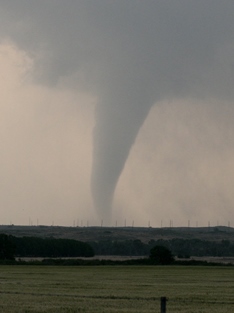
Tornadoes
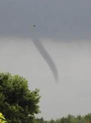
Wall Clouds & Funnel Clouds
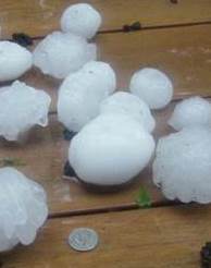
Hail
| Hail Size | Inches |
|---|---|
| Pea | 1/4 |
| Dime | 1/2 |
| Penny | 3/4 |
| Nickel | 7/8 |
| Quarter | 1 |
| Half Dollar | 1 1/4 |
| Ping Pong Ball | 1 1/2 |
| Golf Ball | 1 3/4 |
| Hen Egg | 2 |
| Tennis Ball | 2 1/2 |
| Baseball | 2 3/4 |
| Softball | 4 |
| Grapefruit | 4 1/2 |
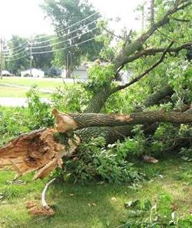
Damaging Winds
| Speed (mph) |
Designation | Description |
|---|---|---|
| <1 | Calm | Smoke rises vertically |
| 1-3 | Light air | Smoke drift indicates wind direction |
| 4-7 | Light breeze | Weather vane moves, leaves rustle |
| 8-12 | Light breeze | Leaves and twigs in constant motion |
| 13-18 | Mod breeze | Dust raised, small branches move |
| 19-24 | Fresh breeze | Small trees sway |
| 25-31 | Strong breeze | Large branches move |
| 32-38 | Moderate gale | Whole trees move, walking affected |
| 39-46 | Fresh gale | Twigs break off trees, walking difficult |
| 47-54 | Strong gale | Minor structural damage |
| 55-63 | Whole gale | Large tree branches break |
| 64-74 | Storm | Widespread damage |
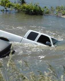
Flash Flooding & Heavy Rain
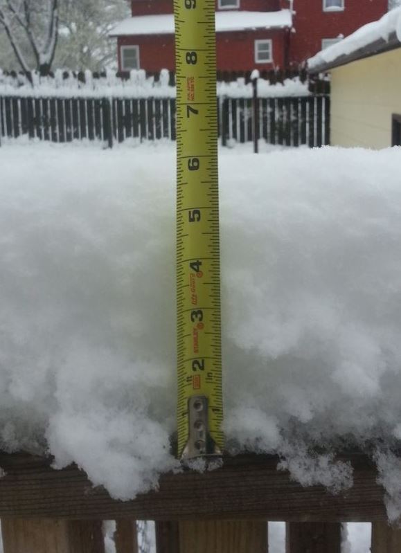
Snow & Ice
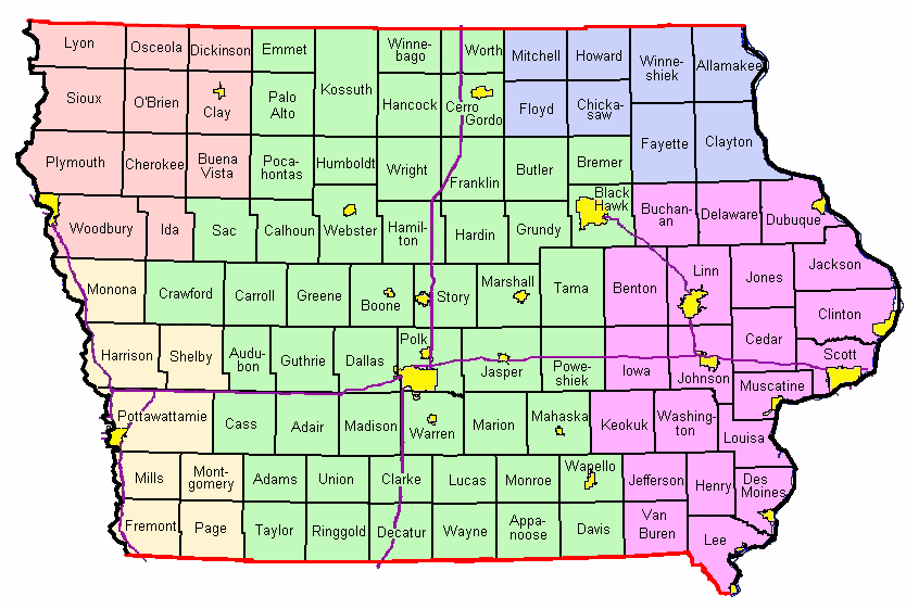
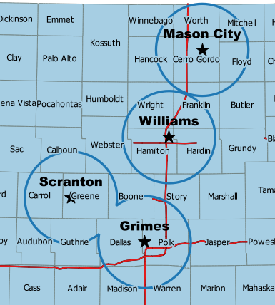
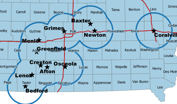
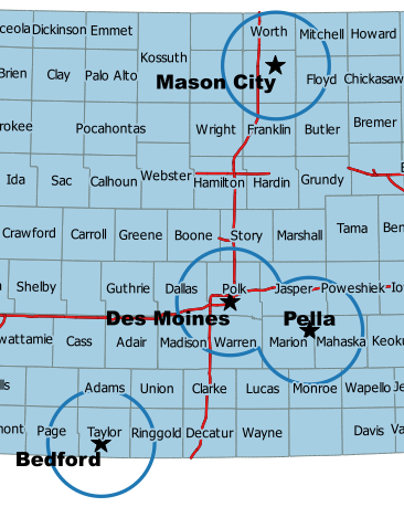
Reporting Across Iowa:
Live in western or eastern Iowa? Click your location below to find out how to report severe weather. The light green shaded region is serviced by the NWS in Des Moines. Other color shades denote areas covered by neighboring offices.
Outlooks, Watches & Warnings
Severe Weather Outlooks:
 |
 |
 |
 |
| Day 1 Outlook | Day 2 Outlook | Day 3 Outlook | Days 4-8 Outlooks |
Severe Weather Discussion, Watches, and Environmental Data:
 |
 |
 |
 |
| Mesoscale Discussions | Active Watches | Outlook, Watches & Radar | Mesoanalysis Data |
Central Iowa Weather and Storm Reports:
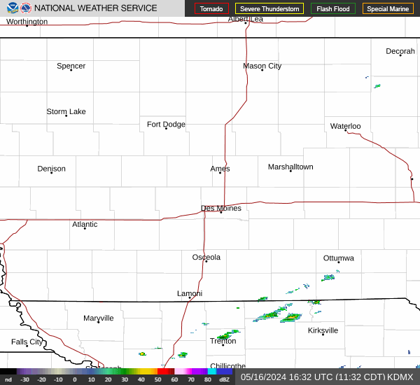 |
 |
 |
|
| Current Radar & Warnings | Today's Storm Reports | Yesterday's Storm Reports |
Spotter Resources
The National Weather Service (NWS) and local county emergency managers host a combination of in-person and webinar-based spotter training classes across Iowa every year between late February and early April. For more information on these classes, please see the Spotter Training tab above.
In addition to live National Weather Service spotter training presentations, there are several online training opportunities available.
Online Resources
Central Iowa Spotter Networks
NWS Des Moines Spotter Network
The NWS Des Moines spotter network is ideal for anyone who wants to report severe weather directly to the National Weather Service! There are over 4500 spotters all 51 central Iowa counties served by the National Weather Service in Des Moines. Benefits of belonging to the network include a private 1-800 telephone line direct to the NWS in Des Moines, the issuance of a unique spotter number that identifies you and your home location in our database, and notification reminders of the upcoming spotter training season.
Interested in becoming part of our network? To join you must:
Register or update your information online - Visit the NWS Des Moines registration page at https://www.weather.gov/dmx/registration.
Emergency Management Spotter Networks
These groups contain fire personnel, law enforcement, local amateur radio groups, and local citizens. They are managed and maintained by the county emergency manager, or other designee. These spotter groups are highly variable depending upon the county. Most reports are sent to the NWS via the 911 Center Dispatcher, or by county EOC. A spotter can belong to both the NWS and county spotter networks!
Amateur Radio Spotter Networks
There are numerous SKYWARN amateur radio spotters across central Iowa. Amateur radio spotters can reach the amateur radio net controller at WFO Des Moines providing the linking systems are operational. During severe weather, amateur radio net controllers operate from the National Weather Service in Des Moines. Net controllers receive spotter reports from amateur radio spotters from across central Iowa. Amateur radio is an excellent way to send severe weather reports in real-time to the National Weather Service!
Amateur Radio Repeaters
Amateur Radio Operators (HAMS) are a vital link in the spotter and communication network used by the NWS during severe or otherwise inclement weather and provide a reliable means of communications to NWS offices should normal communication modes fail. The following graphics depict single repeaters, linked repeater systems, or a combination thereof, which we utilize often. New repeaters continue to be installed by dedicated and hard-working hams to expand their networks. We also continue to learn of and put into use these new systems as soon as possible. For now, we will not list 2 meter and 70 cm repeaters outside of our 51 county warning area (depicted by the purple outline), unless they also serve some of our counties. If you notice errors or omissions drop us a line at nws.desmoines@noaa.gov.
The repeaters shown on the map immediately below use DMR (Digital Mobile Radio) protocol. These repeaters are capable of connection to the Des Moines Weather Forecast office. To utilize DMR for passing severe weather reports you must use the “DMX / SEOC” talkgroup. Please remember that the DMX / SEOC talkgroup is only intended for weather and emergency traffic.

(click to enlarge map)
The following repeater maps and information depict more traditional linked repeater networks. Keep in mind the maps depict approximate signal coverage with radio propagation characteristics, geography, equipment reliability, etc. all affecting coverage of a given repeater. Since many of these repeaters are linked please give them a second or two to connect.
|
 |
||||||||||||||||||||||||||||||||||||
|
|
|||||||||||||||||||||||||||||||||||||
|
 |
||||||||||||||||||||||||||||||||||||
|
|
|||||||||||||||||||||||||||||||||||||
|
 |
||||||||||||||||||||||||||||||||||||
|
|
|||||||||||||||||||||||||||||||||||||
Spotter Training
The National Weather Service (NWS) and local county emergency managers host spotter training classes across Iowa every spring. These in-person spotter training classes are offered across many counties across central Iowa. Every county in the NWS Des Moines county warning area will have the option for an in-person spotter training class at least every other year. Some counties will not have spotter training in 2025. In addition to in-person sessions, one virtual session will be held on Monday, March 31st at 7-830 PM (more information including registration information in calendar entry below).
Both in-person and virtual training sessions are entirely free & open to new & seasoned spotters alike.
Advanced spotter training classes will NOT be held for the 2025 season.
Spotter talks are open to the public on a first come, first serve basis. Prior registration is only required for certain talks, which includes Polk County and all virtual spotter training classes. The schedule at the bottom of the page includes all talks that have been scheduled to date. Scheduling usually takes place in January and February, but again not every county will have a talk.
Register to be a Spotter or Update Previous Information
Runs 75 to 90 minutes in length, is open to the public, and free of charge. Prior registration is not required for most spotter training classes, however a few, including Polk County and all virtual classes, do require advance registration. See the entries in the calendar below for additional details and registration information - if you do not see the registration information, check again soon.
Instructors are NWS Meteorologists - Questions are encouraged and welcome!
Please click on calendar entry below to view more information about the training session.

