 |
Current Conditions Staying Safe |
 |
| Current Watches, Warnings, and Advisories |
|
A Cold Weather Advisory means that apparent temperature values are expected to fall to between -20° and -29°F within the next 24 to 36 hours. Please exercise caution and wear appropriate clothing if heading outdoors for any prolonged period of time. An Extreme Cold Watch means that apparent temperature values are expected to fall to -35°F or lower over northern Iowa or -30°F or lower over the rest of Iowa within the next two to three days. Start planning to limit any outdoor activity during this time. An Extreme Cold Warning means that apparent temperature values are expected to fall to -35°F or lower over northern Iowa or -30°F or lower over the rest of Iowa within the next 24 to 48 hours. Please refrain from any unnecessary outdoor activities and wear protective clothing if you must venture outdoors. You can get frostbite in 10-15 min on unprotected skin. |
 |
 |
| Tonight's Lowest Wind Chill Values | Tomorrow Night's Lowest Wind Chill Values |
|
Click each image above to view a larger version. The tonight time period runs from 6pm to 6am CST.
|
|
 |
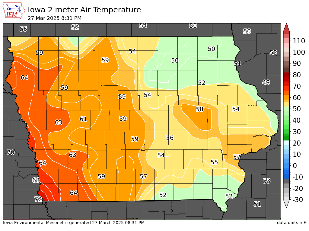 |
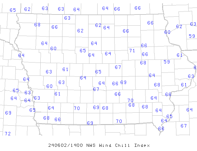
| Current Wind Chill Readings | Current Temperatures |
Here are a few tips to staying safe during times of cold weather:
What is Wind Chill?
The wind chill temperature is not the actual air temperature, it is a “feels like” temperature when one factors in cold temperatures AND wind speeds. Increasing winds will accelerate the amount of heat lost by the body via exposed skin, driving down the body temperature. Animals are also affected by wind chill.
The only effect wind chill has on inanimate objects, such as car radiators and water pipes, is to shorten the amount of time for the object to cool. The inanimate object will not cool below the actual air temperature. For example, if the temperature outside is -5°F and the wind chill temperature is -31°F, then your car's radiator will not drop lower than -5°F.
The wind chill chart below was developed based on joint U.S.-Canadian research. The chart includes a frostbite indicator, showing the points where temperature, wind speed and exposure time will produce frostbite on humans. Each shaded area shows how long a person can be exposed before frostbite develops.

Note: Wind chill temperature is only defined for temperatures at or below 50°F and wind speeds above 3 mph.
Bright sunshine may increase the wind chill temperature by 10 to 18°F.

