
Scattered thunderstorms with severe gusts, hail and a tornado risk are possible near a cold front from the Ohio Valley to the Mid-Atlantic tonight. Tropical Storm Bertha is expected to bring tropical storm conditions to portions of the Gulf Coast from the panhandle of Florida into Louisiana through Wednesday. Read More >
Overview
|
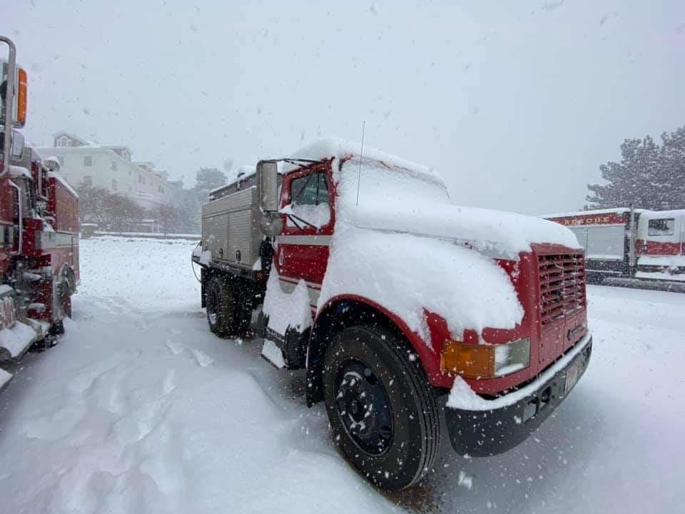
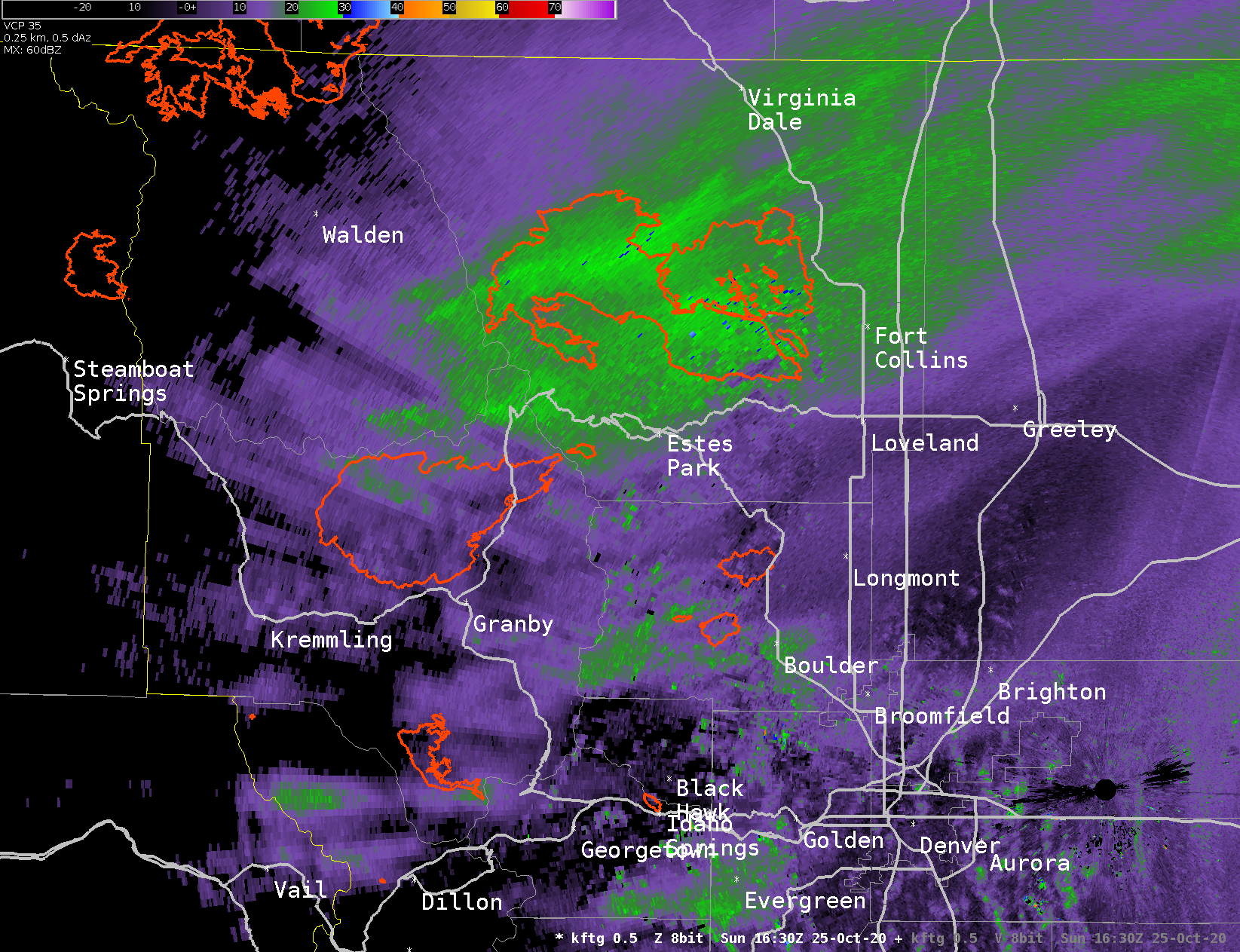
A strong cold front moved through Colorado, with heavy snow developing behind it during the early morning hours of October 25th. A narrow band of heavy snow stalled over the Fort Collins area through much of the morning. Over 4" of snow was reported in Fort Collins in the morning! This heavy band of snow gradually moved south through the day, providing heavy snow to Fort Collins, Loveland, and Boulder through the rest of the morning and early afternoon. At times, the band of heavy snow extended all the way into Nebraska. Areas near Sterling picked up several inches of snow in just a few hours as the snow moved through. By the evening, heavy snow briefly made an appearance in Denver, but quickly shifted south into Douglas and Elbert counties. Light to moderate snow continued across the metro through much of the night, with most areas picking up at least a few inches of snow. Snow ended during the morning hours across northeast Colorado. This snowfall also provided relief to two of the largest fires in state history. Over the Cameron Peak and East Troublesome fires, 6-18 inches of snow fell (depending on elevation). As much as 15 inches of snow was reported in Estes Park, with 7 inches in Granby. Total snowfall accumulations were generally 12-18 inches across Boulder and Larimer mountains and foothills, with one report of 28.3 inches south of Virginia Dale and 19.5 inches just northwest of Mishawaka. In Fort Collins, snowfall of 10-16 inches was common, with one report of 17.7 inches on the west side of town. Totals of 8-14 inches were common across the rest of Boulder and Larimer counties. For Denver metro and the rest of the northeast Plains, totals were in the 4-8 inch range. In addition the snow, the temperature also plummeted across much of the state. On the morning of Tuesday, October 27th, the Walden airport recorded a minimum temperature of -24F! A Cooperative observation station near Walden also fell to -28F. An unofficial CoAgMet station in Hebron, a small town in North Park, fell to -33F! Across the plains, the temperature was a little warmer, but several records were still set. In Denver, a new record cold high temperature was set on Monday (16F, breaking the old record of 31 in 1923), along with a new record low on Tuesday morning (8F, breaking the old record of 11F in 1925). |
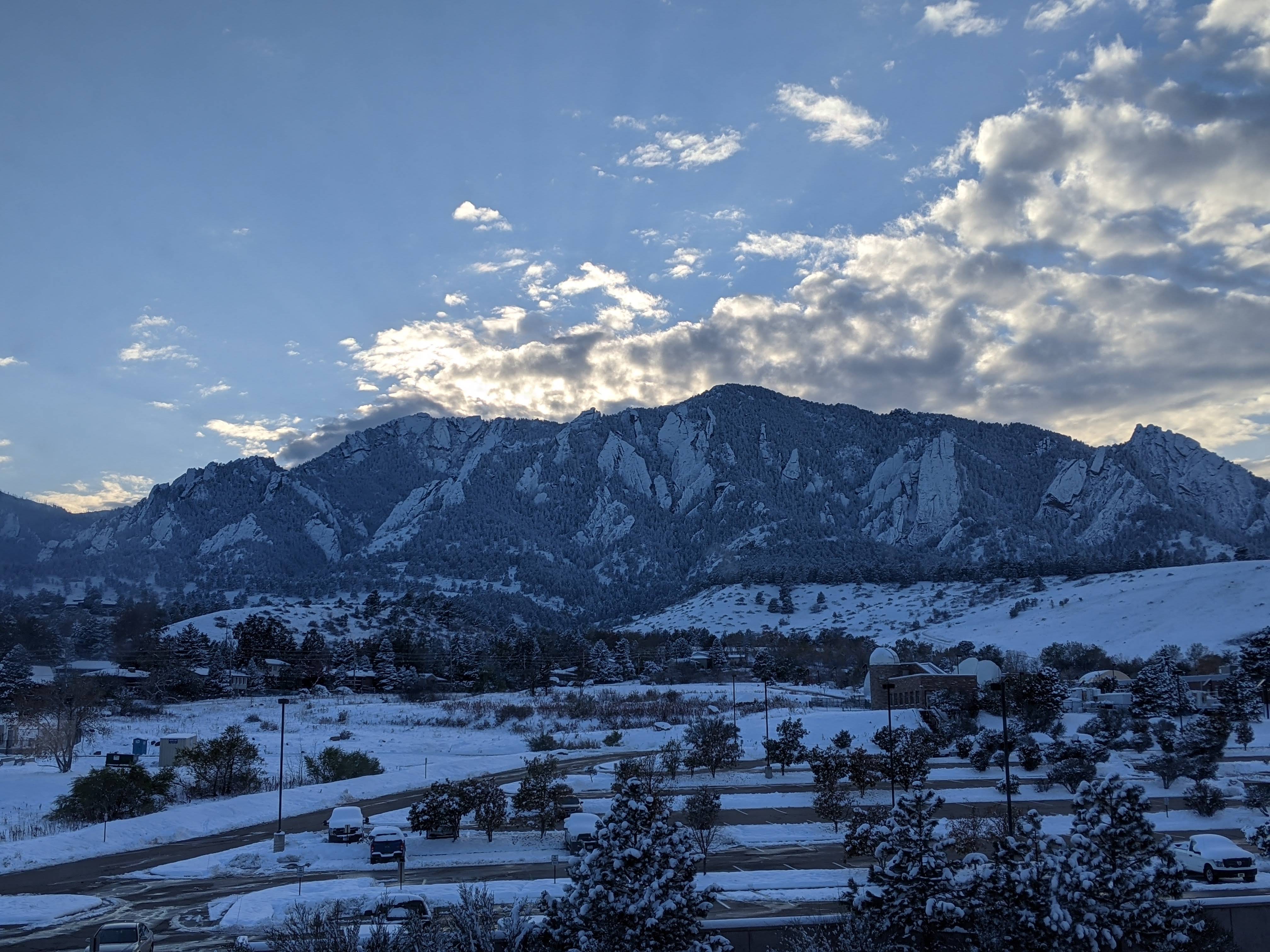
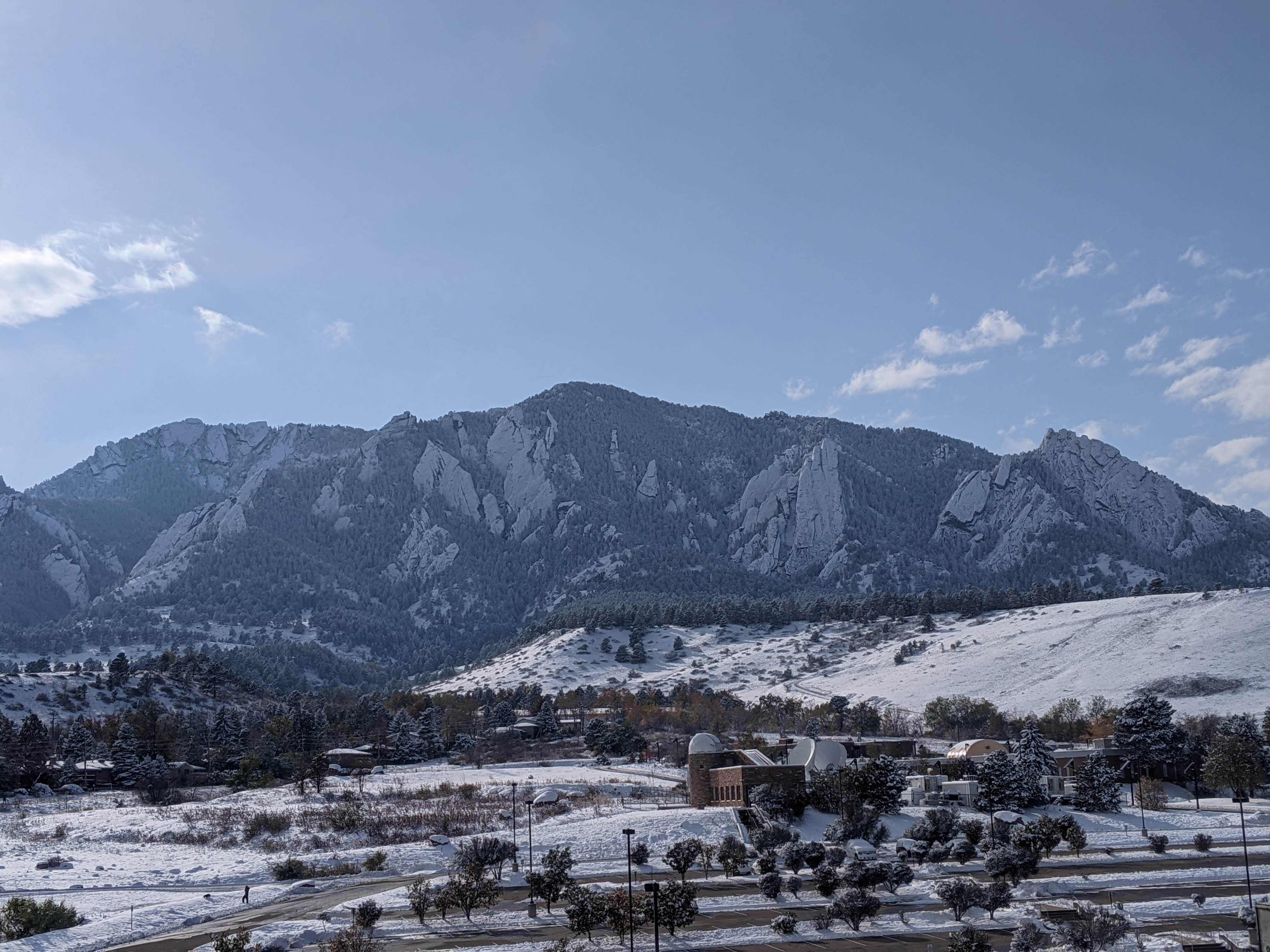 A view of the snow on Monday afternoon from the WFO Boulder office |
Photos
Overview
 |
 |
 |
 |
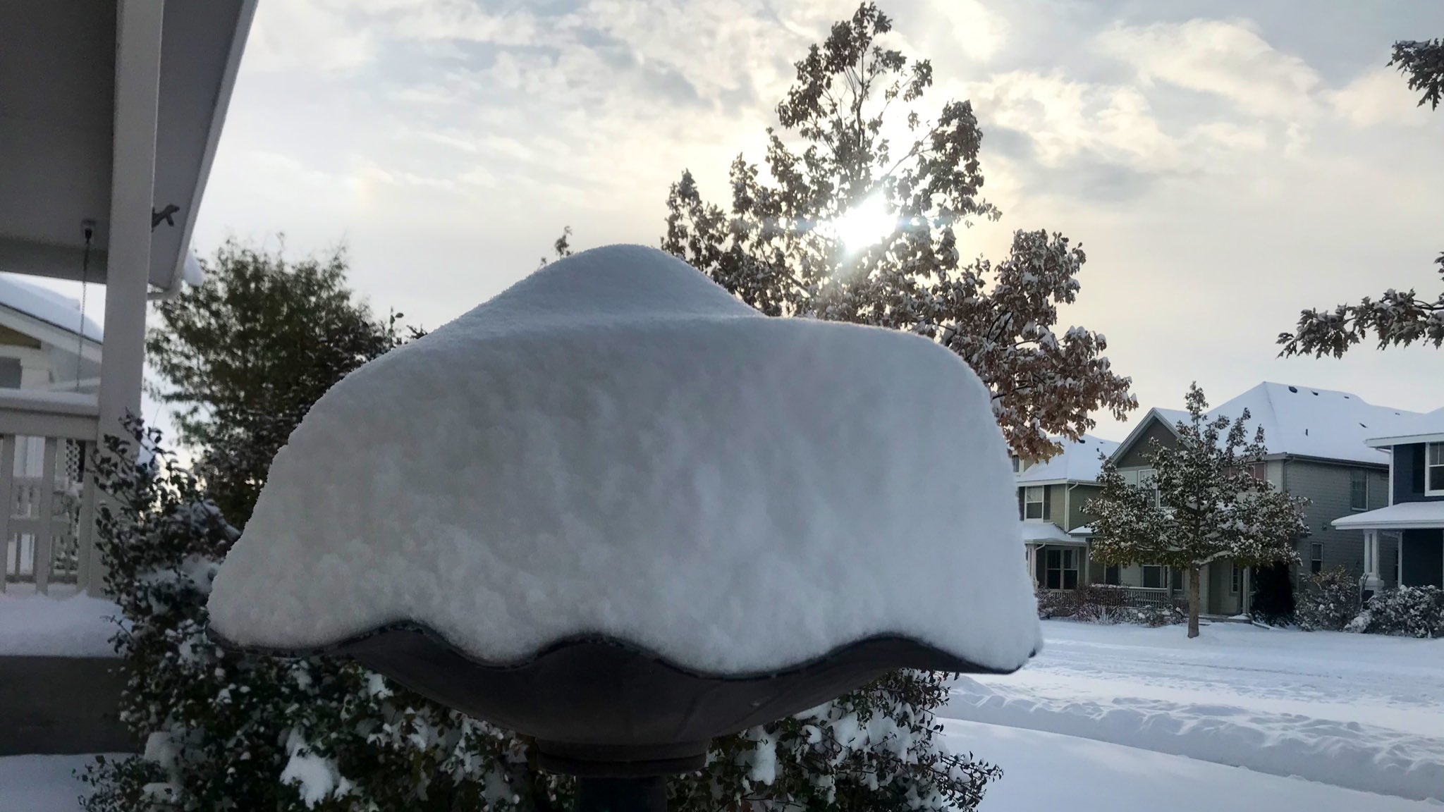
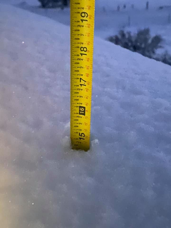
| Snow at the WFO Boulder office during the afternoon of October 26th | Snow in northeast Fort Collins. Photo from Jared Allen (via Twitter) | Snow total in Estes Park. Photo from Sherrie Duris (via Facebook) | Snow on a vehicle at the Incident Command Post for the Cameron Peak Fire (photo via Inciweb) |
Radar & Satellite
Overview
 |
 |
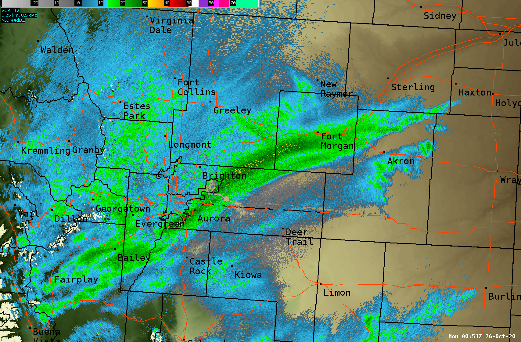 |
| 42 Hour Loop of Mid-Level Water Vapor from 6:00 PM October 24th through 12:00 PM October 26th. Image from CIRA-RAMMB | Radar Loop from 10:30-11:20 AM of the heavy snow band, located over the East Troublesome and Cameron Peak Fires (red outline) | Radar Loop from 5:30-6:30 PM of the heavy snow band quickly moving through the Denver metro. |
Storm Reports
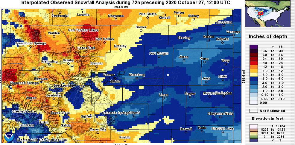 |
| Storm total snowfall for Northeast Colorado. Snowfall analysis from NOHRSC. |
Public Information Statement National Weather Service Denver CO 752 PM MDT Mon Oct 26 2020 ...SNOWFALL REPORTS... Location Amount Time/Date Lat/Lon ...Colorado... ...Adams County... 2 ESE Broomfield 7.9 in 0830 AM 10/26 39.91N/105.04W 1 WNW Northglenn 6.6 in 0842 AM 10/26 39.91N/104.99W 1 NNW Federal Heights 6.0 in 0749 AM 10/26 39.88N/105.03W Westminster 1.6 NE 5.7 in 0700 AM 10/26 39.90N/105.03W 1 ENE Westminster 5.5 in 0945 AM 10/26 39.88N/105.04W Thornton 2.1 N 5.5 in 0700 AM 10/26 39.92N/104.96W Brighton 1.9 NNW 5.2 in 0700 AM 10/26 39.98N/104.81W Brighton 4.0 WNW 4.0 in 0700 AM 10/26 39.97N/104.87W Aurora 4.2 NNW 4.0 in 0700 AM 10/26 39.75N/104.85W ...Arapahoe County... Centennial 2.0 SW 7.7 in 0730 AM 10/26 39.58N/104.97W 1 SE Littleton 7.0 in 0914 AM 10/26 39.58N/105.00W Littleton 5.0 ESE 6.4 in 0700 AM 10/26 39.57N/104.93W 3 NNE Foxfield 6.2 in 0900 AM 10/26 39.63N/104.78W Denver 9.4 S 6.2 in 0700 AM 10/26 39.60N/104.98W 2 ESE Centennial 6.0 in 0700 AM 10/26 39.58N/104.83W 3 SW Aurora 5.8 in 0900 AM 10/26 39.67N/104.85W Aurora 10.0 SSE 5.7 in 0900 AM 10/26 39.57N/104.72W Aurora 4.0 SSE 5.7 in 0700 AM 10/26 39.65N/104.78W 2 SW Greenwood Village 5.5 in 0853 AM 10/26 39.60N/104.93W 1.7 SW Cherry Hills Village 5.5 in 0700 AM 10/26 39.62N/104.97W Centennial 3.7 W 5.4 in 0800 AM 10/26 39.61N/104.94W Aurora 3.3 S 5.3 in 0900 AM 10/26 39.65N/104.82W 2.7 N Foxfield 4.7 in 0700 AM 10/26 39.63N/104.80W 3 SW Arapahoe Park 4.5 in 0837 AM 10/26 39.61N/104.72W Bennett 10.8 SSW 4.5 in 0700 AM 10/26 39.61N/104.51W Englewood 1.4 N 4.4 in 0700 AM 10/26 39.67N/104.99W Denver 6.3 SSE 4.4 in 0650 AM 10/26 39.68N/104.88W 3 SSE Aurora 4.0 in 0815 AM 10/26 39.67N/104.79W Aurora 5.7 E 4.0 in 0700 AM 10/26 39.69N/104.71W Foxfield 3.7 ESE 4.0 in 0600 AM 10/26 39.57N/104.73W Aurora 0.7 WSW 3.1 in 0600 AM 10/26 39.69N/104.82W 2.1 W Byers 3.0 in 0700 AM 10/26 39.70N/104.26W ...Boulder County... Allenspark 2.3 N 14.3 in 0700 AM 10/26 40.23N/105.53W Allenspark 2.2 ESE 14.0 in 0800 AM 10/26 40.19N/105.48W 4 ENE Nederland 13.0 in 0732 AM 10/26 39.99N/105.45W Boulder 1.8 ESE 12.9 in 0700 AM 10/26 40.01N/105.23W Nederland 2.8 NE 12.9 in 0700 AM 10/26 39.99N/105.47W Nederland .47 ESE 12.6 in 0700 AM 10/26 39.96N/105.50W Boulder 1.6 S 12.4 in 0700 AM 10/26 39.99N/105.26W 3 SSW Boulder 12.0 in 0701 AM 10/26 39.99N/105.27W Boulder 4.2 ENE 12.0 in 0700 AM 10/26 40.06N/105.18W Boulder 4.7 E 12.0 in 0700 AM 10/26 40.00N/105.18W 4 ENE Nederland 12.0 in 0945 PM 10/25 39.99N/105.45W Jamestown 2.5 SSE 11.9 in 0740 AM 10/26 40.08N/105.37W Boulder 2.9 S 11.9 in 0700 AM 10/26 39.99N/105.26W Boulder 2.3 SSW 11.8 in 0700 AM 10/26 40.00N/105.27W Boulder 1.4 SE 11.5 in 0700 AM 10/26 40.01N/105.24W 2 SSW Boulder 11.3 in 0600 AM 10/26 39.99N/105.26W Boulder 2.1 W 11.0 in 0700 AM 10/26 40.03N/105.29W Ward 4.6 NE 10.8 in 0700 AM 10/26 40.11N/105.44W 5 SSE Longmont 10.6 in 0749 AM 10/26 40.12N/105.06W Boulder 1.8 NW 10.6 in 0700 AM 10/26 40.05N/105.28W Crisman 10.5 in 0840 AM 10/26 40.04N/105.36W Boulder 1.5 WNW 10.5 in 0700 AM 10/26 40.04N/105.28W Nederland 2.61 NNE 10.3 in 0700 AM 10/26 39.99N/105.48W Boulder 2.3 N 10.1 in 0700 AM 10/26 40.06N/105.24W Lafayette 2.3 WNW 10.0 in 0700 AM 10/26 40.00N/105.14W Erie 1.9 WNW 10.0 in 0700 AM 10/26 40.04N/105.08W Nederland 0.4 WNW 10.0 in 0700 AM 10/26 39.97N/105.51W Boulder 4.7 ENE 9.6 in 0700 AM 10/26 40.06N/105.17W Longmont 3.3 SW 9.5 in 0700 AM 10/26 40.14N/105.16W Niwot 2.2 SW 9.4 in 0700 AM 10/26 40.07N/105.19W Lyons 0.3 NNE 9.3 in 0700 AM 10/26 40.23N/105.27W Boulder 2.0 W 9.2 in 0700 AM 10/26 40.02N/105.29W Erie 1.7 WNW 9.1 in 0700 AM 10/26 40.04N/105.07W Boulder 2.5 SSE 9.0 in 0800 AM 10/26 39.99N/105.24W Boulder 3.6 WNW 8.9 in 0815 AM 10/26 40.04N/105.33W Longmont 2.1 N 8.3 in 0700 AM 10/26 40.20N/105.11W Longmont 0.3 W 8.3 in 0700 AM 10/26 40.17N/105.12W Longmont 8.3 in 0644 AM 10/26 40.17N/105.11W Louisville 1.6 NNE 8.1 in 0720 AM 10/26 39.99N/105.13W Longmont 1.8 E 8.1 in 0700 AM 10/26 40.17N/105.08W 2 WSW Louisville 8.0 in 0755 AM 10/26 39.96N/105.18W 1 NNW Louisville 8.0 in 0745 AM 10/26 39.98N/105.15W Erie 1.7 WNW 7.3 in 0800 AM 10/26 40.04N/105.08W Boulder 7.4 NNW 7.3 in 0700 AM 10/26 40.13N/105.29W 1.4 NW Hygiene 7.0 in 0700 AM 10/26 40.20N/105.18W 1 NNW Louisville 6.9 in 0230 AM 10/26 39.99N/105.15W 2 WSW Louisville 6.8 in 0855 PM 10/25 39.96N/105.18W Nederland 5.8 E 6.0 in 0700 AM 10/26 39.97N/105.40W 1.3 NE Lafayette 6.0 in 0700 AM 10/26 40.01N/105.09W Lafayette 0.8 WSW 5.7 in 0700 AM 10/26 39.99N/105.11W ...Broomfield County... 1 NW Broomfield 6.7 in 0749 AM 10/26 39.94N/105.09W Broomfield 1.2 NE 6.7 in 0700 AM 10/26 39.94N/105.08W Broomfield 1.9 WSW 6.6 in 0800 AM 10/26 39.93N/105.09W ...Clear Creek County... Evergreen 5 W 6.0 in 0700 AM 10/26 39.64N/105.41W Georgetown 4 S 6.0 in 0600 AM 10/26 39.66N/105.71W 0.7 S Georgetown 5.4 in 0800 AM 10/26 39.71N/105.70W ...Denver County... Denver 4.3 WNW 6.0 in 0700 AM 10/26 39.76N/105.03W 1 WSW Cherry Creek Reservoir 5.8 in 0903 AM 10/26 39.63N/104.89W 1 E Mountain View 5.5 in 0755 AM 10/26 39.78N/105.04W Denver 2.1 ESE 5.3 in 0700 AM 10/26 39.73N/104.95W Denver 8 SSW 4.5 in 0800 AM 10/26 39.63N/105.05W 1 E Edgewater 4.5 in 0721 AM 10/26 39.75N/105.04W Denver 1.1 NE 4.4 in 0800 AM 10/26 39.74N/104.95W Denver 6.1 SW 4.3 in 0700 AM 10/26 39.67N/105.05W Denver 2.1 ENE 4.2 in 0700 AM 10/26 39.73N/104.92W 2 SE Denver Intl Airport 4.0 in 1200 PM 10/26 39.85N/104.66W 2 ENE Denver 4.0 in 0907 AM 10/26 39.74N/104.96W 1 S Denver 4.0 in 0700 AM 10/26 39.72N/104.99W Denver 5.1 ENE 4.0 in 0700 AM 10/26 39.76N/104.87W Littleton 3 WNW 4.0 in 0700 AM 10/26 39.62N/105.07W Denver 4.0 in 0654 AM 10/26 39.73N/104.99W Denver 2.6 SSW 3.3 in 0700 AM 10/26 39.69N/104.97W 4.5 SE Commerce City 3.3 in 0600 AM 10/26 39.76N/104.87W 1 E Edgewater 2.0 in 0837 PM 10/25 39.75N/105.04W ...Douglas County... 2 SSE Kassler 9.0 in 0800 AM 10/26 39.47N/105.08W Castle Rock 1.7 SSW 8.0 in 0800 AM 10/26 39.35N/104.86W Highlands Ranch 3.0 WSW 7.9 in 0700 AM 10/26 39.53N/105.02W Castle Pines 2.6 NNE 7.5 in 0800 AM 10/26 39.47N/104.89W Beverly Hills 2.0 WNW 7.5 in 0800 AM 10/26 39.48N/104.91W Castle Rock 0.5 NNW 7.2 in 0915 AM 10/26 39.39N/104.85W 2 W Parker 7.0 in 0800 AM 10/26 39.51N/104.81W 3.0 E Franktown 7.0 in 0700 AM 10/26 39.39N/104.69W The Pinery 1.2 ESE 7.0 in 0700 AM 10/26 39.45N/104.71W 2 S Parker 6.8 in 0800 AM 10/26 39.49N/104.77W 2 W Lone Tree 6.5 in 0906 AM 10/26 39.53N/104.93W 1 NW Highlands Ranch 6.5 in 0900 AM 10/26 39.56N/104.98W 3 ENE Sedalia 6.5 in 0700 AM 10/26 39.44N/104.92W The Pinery 1.2 ESE 6.5 in 0700 AM 10/26 39.45N/104.71W Highlands Ranch 0.7 ESE 6.3 in 0800 AM 10/26 39.55N/104.96W 3 SSW Castle Pines 6.3 in 0601 AM 10/26 39.43N/104.90W Franktown 3.5 NE 6.2 in 0827 AM 10/26 39.43N/104.70W 4 S Greenland 6.0 in 0700 AM 10/26 39.13N/104.84W 2 W Lone Tree 5.0 in 0917 AM 10/26 39.53N/104.93W Surrey Ridge 0.2 SSW 5.0 in 0800 AM 10/26 39.50N/104.88W 0.9 NW Lone Tree 4.5 in 0700 AM 10/26 39.55N/104.90W Highlands Ranch 0.6 SSE 4.1 in 0700 AM 10/26 39.55N/104.97W ...Elbert County... 2.0 NE Elizabeth 9.0 in 0700 AM 10/26 39.38N/104.58W 1 WNW Ponderosa Park 8.0 in 0921 AM 10/26 39.41N/104.66W 5 NNE Ponderosa Park 7.0 in 0831 AM 10/26 39.47N/104.60W Elizabeth 2.0 NNE 7.0 in 0700 AM 10/26 39.39N/104.59W Elizabeth 10.5 NNE 6.0 in 0900 AM 10/26 39.50N/104.52W Elizabeth 5.4 in 0700 AM 10/26 39.36N/104.60W 6 ENE The Pinery 4.1 in 0700 AM 10/26 39.49N/104.63W ...Gilpin County... Rollinsville 1.1 SSW 10.6 in 0700 AM 10/26 39.91N/105.51W Aspen Springs 9.0 in 0700 AM 10/26 39.83N/105.48W 1 WSW Aspen Springs 5.0 in 0901 PM 10/25 39.83N/105.50W ...Grand County... 2 SSE Tabernash 8.0 in 0450 AM 10/26 39.95N/105.84W Granby 7.0 in 0700 AM 10/26 40.09N/105.94W Williams Fork Reservoir 5.5 in 0800 AM 10/26 40.04N/106.20W ...Jackson County... 1.1 SE Gould 20.0 in 0900 AM 10/26 40.51N/106.01W ...Jefferson County... Golden 1.6 SW 9.3 in 0700 AM 10/26 39.72N/105.24W Sedalia 22 SW 8.0 in 0730 AM 10/26 39.22N/105.28W 1 NNW Genesee 8.0 in 0645 AM 10/26 39.70N/105.28W Littleton 5.7 SW 7.5 in 0700 AM 10/26 39.54N/105.10W Ken Caryl 0.6 WSW 7.5 in 0600 AM 10/26 39.57N/105.12W Kittredge 2.5 SSE 7.3 in 0700 AM 10/26 39.62N/105.28W 2 WNW Arvada 7.0 in 0957 AM 10/26 39.83N/105.15W 1 SSW Crescent Village 7.0 in 0857 AM 10/26 39.91N/105.34W 2 SSW Rocky Flats 7.0 in 0728 AM 10/26 39.87N/105.22W Wheat Ridge 2.8 WSW 7.0 in 0700 AM 10/26 39.76N/105.15W Westminster 1.1 SW 6.8 in 0800 AM 10/26 39.87N/105.07W 1 ENE Ken Caryl 6.5 in 0730 AM 10/26 39.58N/105.13W Lakewood 1.7 SW 6.2 in 0700 AM 10/26 39.68N/105.14W Conifer 3.9 SE 6.1 in 0700 AM 10/26 39.48N/105.24W Wheat Ridge 0.3 SSW 6.0 in 0715 AM 10/26 39.77N/105.10W Golden 11.8 NW 6.0 in 0700 AM 10/26 39.90N/105.35W 3.4 W Aspen Park 6.0 in 0700 AM 10/26 39.55N/105.36W 1 NNE Arvada 5.8 in 0810 AM 10/26 39.84N/105.09W Lakewood 1.5 WSW 5.8 in 0700 AM 10/26 39.69N/105.14W Golden 9.4 WNW 5.7 in 0700 AM 10/26 39.77N/105.39W Wheat Ridge 1.4 WSW 5.6 in 0700 AM 10/26 39.76N/105.12W 2 NE Arvada 5.5 in 0733 AM 10/26 39.85N/105.08W Wheat Ridge 1.2 ENE 5.5 in 0700 AM 10/26 39.78N/105.08W Bergen Park 1.1 N 5.5 in 0700 AM 10/26 39.71N/105.36W 3 WNW Arvada 5.4 in 0415 AM 10/26 39.85N/105.16W Arvada 2.9 W 5.3 in 0700 AM 10/26 39.82N/105.16W 1.0 W Wheat Ridge 5.2 in 0700 AM 10/26 39.77N/105.12W Arvada 1.4 NNW 5.2 in 0700 AM 10/26 39.84N/105.12W Littleton 6.4 W 5.2 in 0700 AM 10/26 39.61N/105.14W Conifer 3.2 SW 5.1 in 0700 AM 10/26 39.49N/105.35W Denver 11.0 SSW 5.1 in 0700 AM 10/26 39.59N/105.08W Pleasant View 5.0 in 0904 PM 10/25 39.72N/105.17W 3 SSE Lakewood 5.0 in 0816 AM 10/26 39.65N/105.08W Littleton 6.0 W 5.0 in 0730 AM 10/26 39.62N/105.13W 1 ENE Arvada 5.0 in 0726 AM 10/26 39.83N/105.09W Evergreen 5.3 S 5.0 in 0700 AM 10/26 39.56N/105.31W 2 NE Pleasant View 5.0 in 0700 AM 10/26 39.75N/105.14W Wheat Ridge 0.6 S 4.9 in 0700 AM 10/26 39.77N/105.10W Evergreen 2.0 ESE 4.9 in 0700 AM 10/26 39.62N/105.31W 1.2 SW Kittredge 4.8 in 0800 AM 10/26 39.64N/105.31W Westminster 3.0 WSW 4.8 in 0700 AM 10/26 39.87N/105.11W Evergreen 3.5 SE 4.7 in 0830 AM 10/26 39.60N/105.30W 2 SSW Kittredge 4.1 in 0830 AM 10/26 39.62N/105.31W Lakewood 2.2 ESE 4.1 in 0700 AM 10/26 39.68N/105.08W Broomfield 2.3 SSW 4.1 in 0628 AM 10/26 39.88N/105.11W Littleton 4.7 W 4.0 in 0700 AM 10/26 39.62N/105.10W 2.5 E Lakewood 4.0 in 0700 AM 10/26 39.68N/105.07W 2.6 E White Ranch Open Space 3.5 in 0800 AM 10/26 39.83N/105.24W ...Larimer County... Virginia Dale 7.2 SSW 28.3 in 0700 AM 10/26 40.85N/105.40W Livermore 10.5 WSW 19.5 in 0700 AM 10/26 40.75N/105.41W Red Feather Lakes 3.8 ENE 18.3 in 0730 AM 10/26 40.82N/105.51W Horsetooth Mountain 3.2 NNW 18.0 in 0730 AM 10/26 40.58N/105.22W Fort Collins 2.8 W 17.7 in 0700 AM 10/26 40.56N/105.12W Fort Collins 2.5 NW 16.1 in 0700 AM 10/26 40.58N/105.10W Bellvue 5.9 W 15.3 in 0830 AM 10/26 40.60N/105.28W 2 W Estes Park 15.0 in 1030 AM 10/26 40.37N/105.56W 7.4 W Rustic 15.0 in 0700 AM 10/26 40.70N/105.71W FCL 2.2 NW 14.8 in 0745 AM 10/26 40.60N/105.12W FCL 2.55 NE 14.6 in 0700 AM 10/26 40.61N/105.06W Fort Collins 2.8 NE 14.1 in 0700 AM 10/26 40.61N/105.04W Bellvue 5.0 W 14.0 in 0700 AM 10/26 40.62N/105.26W FCL 2.3 NW 13.7 in 0700 AM 10/26 40.60N/105.12W LOV 4.0 W 13.5 in 0700 AM 10/26 40.39N/105.16W Wellington 3.7 WNW 13.3 in 0700 AM 10/26 40.72N/105.07W Fort Collins 2.5 WSW 12.9 in 0700 AM 10/26 40.54N/105.11W Loveland 2.4 NW 12.8 in 0700 AM 10/26 40.44N/105.11W Fort Collins 0.7 SSW 12.5 in 0700 AM 10/26 40.55N/105.07W Drake 4.3 WSW 12.5 in 0700 AM 10/26 40.41N/105.41W Fort Collins 5.4 N 12.4 in 0700 AM 10/26 40.64N/105.08W Fort Collins 1.2 SE 12.2 in 0700 AM 10/26 40.54N/105.05W Fort Collins 4.6 N 12.0 in 0700 AM 10/26 40.62N/105.06W FCL 5.6 E 12.0 in 0700 AM 10/26 40.57N/104.98W Fort Collins 1.3 ENE 11.7 in 0700 AM 10/26 40.57N/105.05W 4 NE Fort Collins 11.5 in 0926 AM 10/26 40.60N/105.01W Bellvue 1 NW 11.2 in 0700 AM 10/26 40.63N/105.18W Lyons 4.8 N 11.0 in 0800 AM 10/26 40.29N/105.27W Wellington 0.8 SW 11.0 in 0700 AM 10/26 40.70N/105.01W Fort Collins 4.9 N 11.0 in 0700 AM 10/26 40.63N/105.06W Fort Collins 3.7 S 10.9 in 0700 AM 10/26 40.50N/105.07W Fort Collins 4.6 S 10.9 in 0700 AM 10/26 40.49N/105.08W Fort Collins 4.6 N 10.5 in 0720 AM 10/26 40.62N/105.06W Lyons 8.9 WNW 10.5 in 0700 AM 10/26 40.27N/105.43W Wellington 0.4 NW 10.3 in 0800 AM 10/26 40.71N/105.01W Timnath 2.1 SE 10.3 in 0700 AM 10/26 40.51N/104.96W LOV 5.0 S 10.3 in 0700 AM 10/26 40.34N/105.09W 2 ESE Fort Collins 10.2 in 0852 AM 10/26 40.54N/105.03W 3 E Laporte 10.2 in 0720 AM 10/26 40.62N/105.06W Berthoud 2.5 N 10.1 in 0730 AM 10/26 40.34N/105.09W Berthoud 2.3 N 10.0 in 0700 AM 10/26 40.34N/105.09W Berthoud 4.4 WSW 9.6 in 0700 AM 10/26 40.28N/105.16W LOV 3.4 S 9.5 in 0700 AM 10/26 40.37N/105.10W Campion 1.8 NNE 9.1 in 0700 AM 10/26 40.37N/105.08W Loveland 3.2 E 9.0 in 0700 AM 10/26 40.41N/105.01W Windsor 3.7 WSW 9.0 in 0700 AM 10/26 40.47N/104.98W Timnath 4.1 NNE 9.0 in 0700 AM 10/26 40.59N/104.96W Windsor 2.6 SW 8.8 in 0700 AM 10/26 40.46N/104.95W LOV 3.8 S 8.7 in 0700 AM 10/26 40.37N/105.10W Loveland 3.0 NNE 8.4 in 0700 AM 10/26 40.44N/105.06W ...Lincoln County... Hugo 0.3 SSW 4.0 in 0700 AM 10/26 39.13N/103.47W Limon 0.3 W 2.0 in 0700 AM 10/26 39.27N/103.70W ...Logan County... Sterling 1.5 S 4.5 in 0700 AM 10/26 40.63N/103.21W 0.6 S Crook 4.0 in 0700 AM 10/26 40.85N/102.80W Crook 4.0 in 0630 AM 10/26 40.86N/102.80W ...Morgan County... Wiggins 1.1 S 4.5 in 0730 AM 10/26 40.21N/104.08W 1.0 SW Fort Morgan 4.0 in 0700 AM 10/26 40.25N/103.81W 0.9 E Gary 3.8 in 0700 AM 10/26 40.07N/103.57W ...Park County... 4 N Kenosha Pass 8.0 in 0713 AM 10/26 39.48N/105.77W Lake George 7.2 WNW 7.6 in 0700 AM 10/26 39.02N/105.49W Fairplay 2.7 WNW 7.1 in 0700 AM 10/26 39.23N/106.05W 0.7 E 11-Mile Canyon Reservo 6.0 in 0700 AM 10/26 38.91N/105.47W Grant 1 W 4.0 in 0730 AM 10/26 39.46N/105.68W ...Sedgwick County... Julesburg 0.1 WNW 4.0 in 0700 AM 10/26 40.99N/102.27W ...Summit County... Heeney 0.5 NW 12.0 in 0700 AM 10/26 39.87N/106.31W Silverthorne 21 NW 9.1 in 0700 AM 10/26 39.90N/106.31W Silverthorne 2.1 WSW 8.0 in 0700 AM 10/26 39.62N/106.10W Silverthorne 1.0 NNE 7.0 in 0800 AM 10/26 39.67N/106.08W Frisco 0.5 N 6.5 in 0700 AM 10/26 39.58N/106.10W ...Washington County... Otis 5.7 W 3.0 in 0700 AM 10/26 40.16N/103.07W ...Weld County... Nunn 1.2 ENE 10.0 in 0800 AM 10/26 40.71N/104.76W Greeley 1.8 N 9.7 in 0700 AM 10/26 40.43N/104.70W 7 NNE Purcell 9.6 in 1030 PM 10/25 40.72N/104.52W Carr 0.6 S 9.5 in 0700 AM 10/26 40.89N/104.88W Greeley 10.5 SSE 9.1 in 0700 AM 10/26 40.29N/104.64W 1 N Erie 9.0 in 0943 PM 10/25 40.04N/105.05W 1 S Greeley 8.8 in 1022 AM 10/26 40.40N/104.75W Greeley 2.6 W 8.8 in 0900 AM 10/26 40.40N/104.75W Greeley 1.1 ENE 8.8 in 0700 AM 10/26 40.43N/104.73W 2 NNE Erie 8.2 in 0845 AM 10/26 40.06N/105.03W 1 W Firestone 8.2 in 0819 AM 10/26 40.12N/104.96W 1 E Greeley 8.0 in 0824 AM 10/26 40.42N/104.73W New Raymer 21 N 8.0 in 0600 AM 10/26 40.93N/103.87W Greeley 2.0 E 7.5 in 0700 AM 10/26 40.42N/104.71W Fort Lupton 7.4 NW 7.2 in 0700 AM 10/26 40.17N/104.89W 1 W Mead 7.0 in 0928 AM 10/26 40.24N/105.01W Nunn 6.5 NE 7.0 in 0700 AM 10/26 40.77N/104.69W 3.5 NW Greeley 7.0 in 0700 AM 10/26 40.47N/104.77W Eaton 3.6 WSW 7.0 in 0700 AM 10/26 40.51N/104.77W Greeley 5.2 SW 6.5 in 0700 AM 10/26 40.36N/104.78W Briggsdale 0.5 WNW 6.5 in 0700 AM 10/26 40.63N/104.33W Eaton 3.4 SE 6.0 in 0700 AM 10/26 40.49N/104.67W Hudson 4.8 WSW 5.5 in 0700 AM 10/26 40.04N/104.73W Kersey 4.5 E 5.4 in 0700 AM 10/26 40.39N/104.47W Observations are collected from a variety of sources with varying equipment and exposures. We thank all volunteer weather observers for their dedication. Not all data listed are considered official.
Environment
An upper level low pressure system strengthened and moved south from Montana towards the Four Corners region. Upper level winds speeds were also much stronger than normal. After the surface cold front passed, this was a favorable setup for snow!
 |
 |
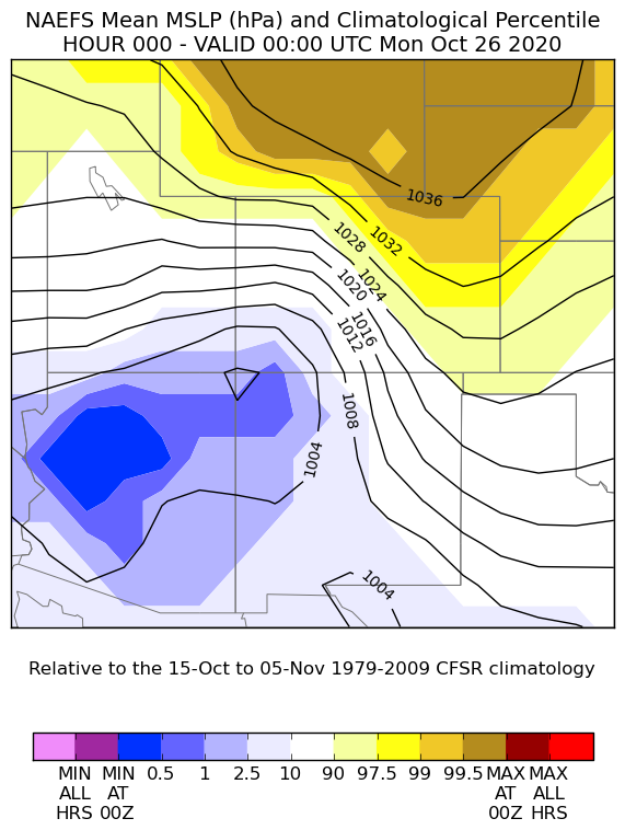 |
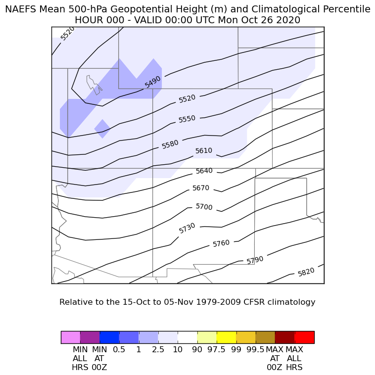
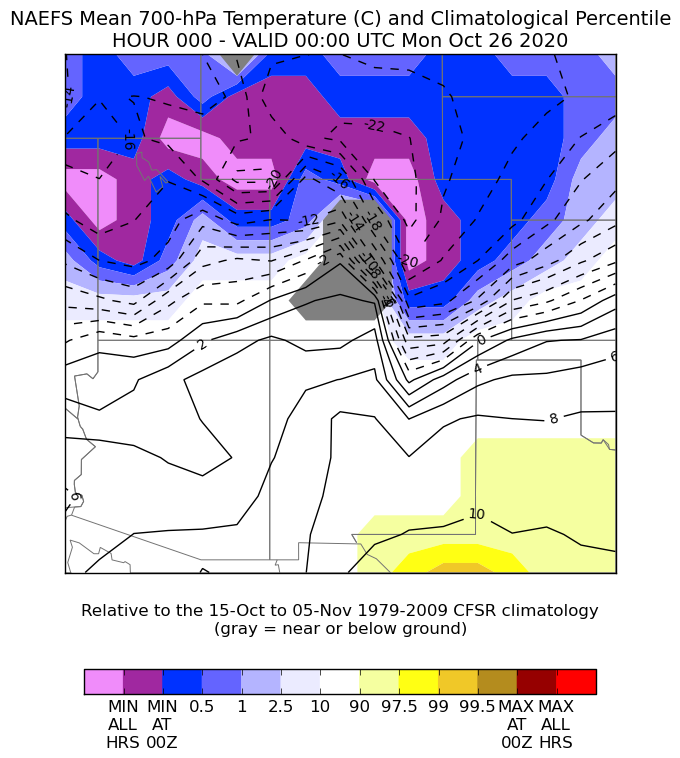
| Figure 1: 500mb Height and NAEFS Climatological Percentile. Lower percentiles (darker shades of blue/purple) indicate exceedingly rare occurrences of low 500mb Heights. | Figure 2: 700mb Temperatures and NAEFS Climatological Percentile. Across much of northeastern Colorado, 700mb temperatures were at or very close to their record coldest values! | Figure 3: A strong high pressure system to the north of Colorado also helped bring very cold air to the area. |
 |
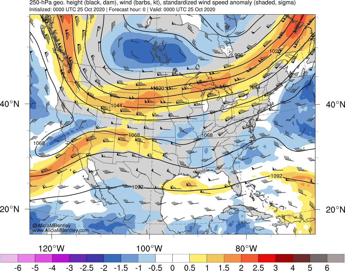 |
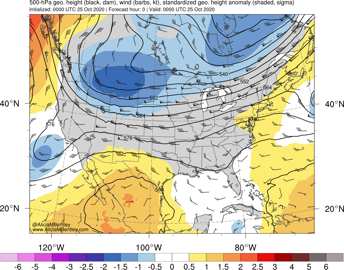
| Figure 4: 500mb Height, Wind Barbs, and Standardized Height Anomalies. For these maps, a large standardized anomaly value (either low or high) indicates that the 500mb height is rarely ever that low (or high) | Figure 5: 250mb Height, Wind Barbs, and Standardized Wind Speed Anomalies. In this map, the higher values of standardized anomalies mean that the jet stream was much stronger than normal over the area |
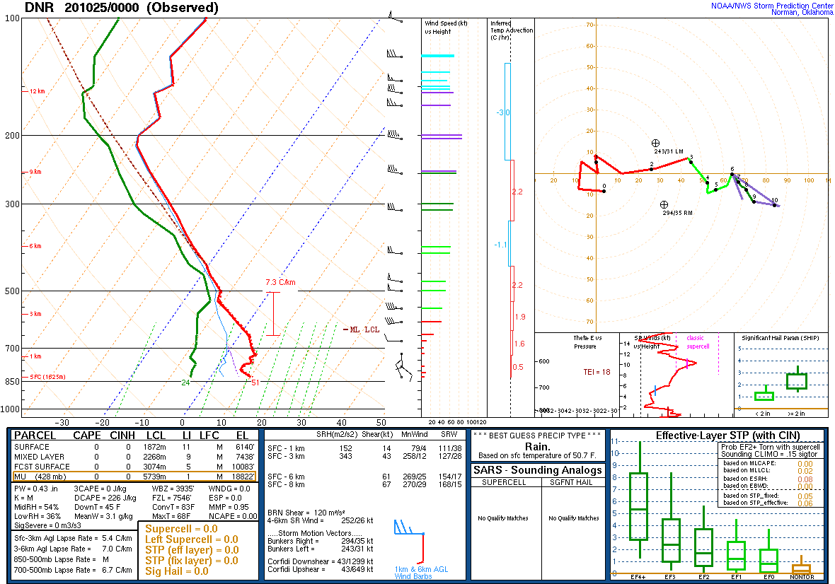
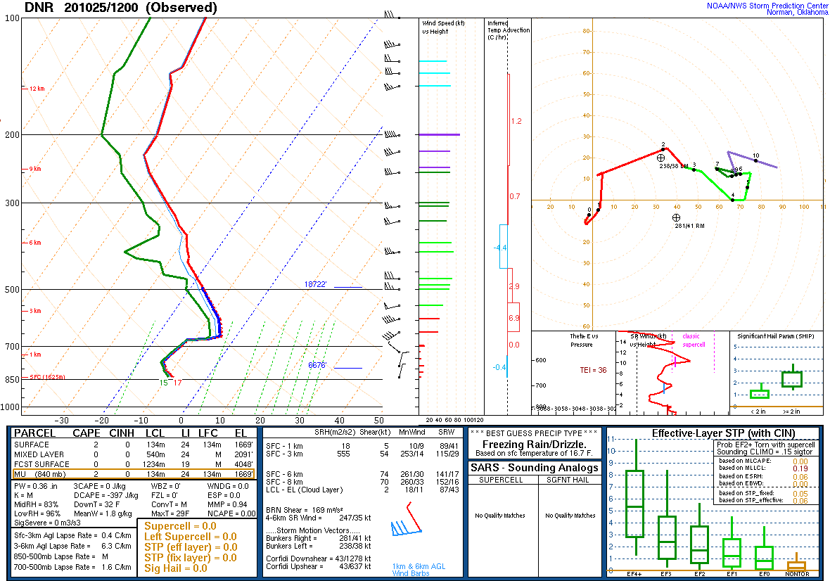
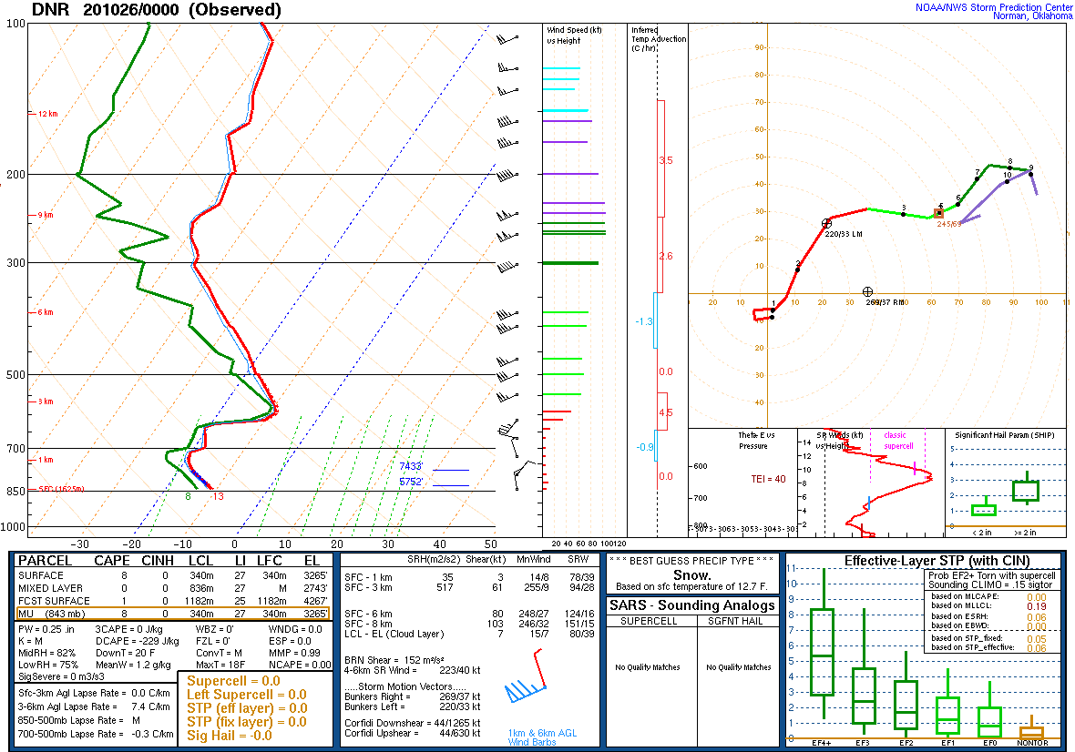
Observed Soundings near Denver:
 |
 |
 |
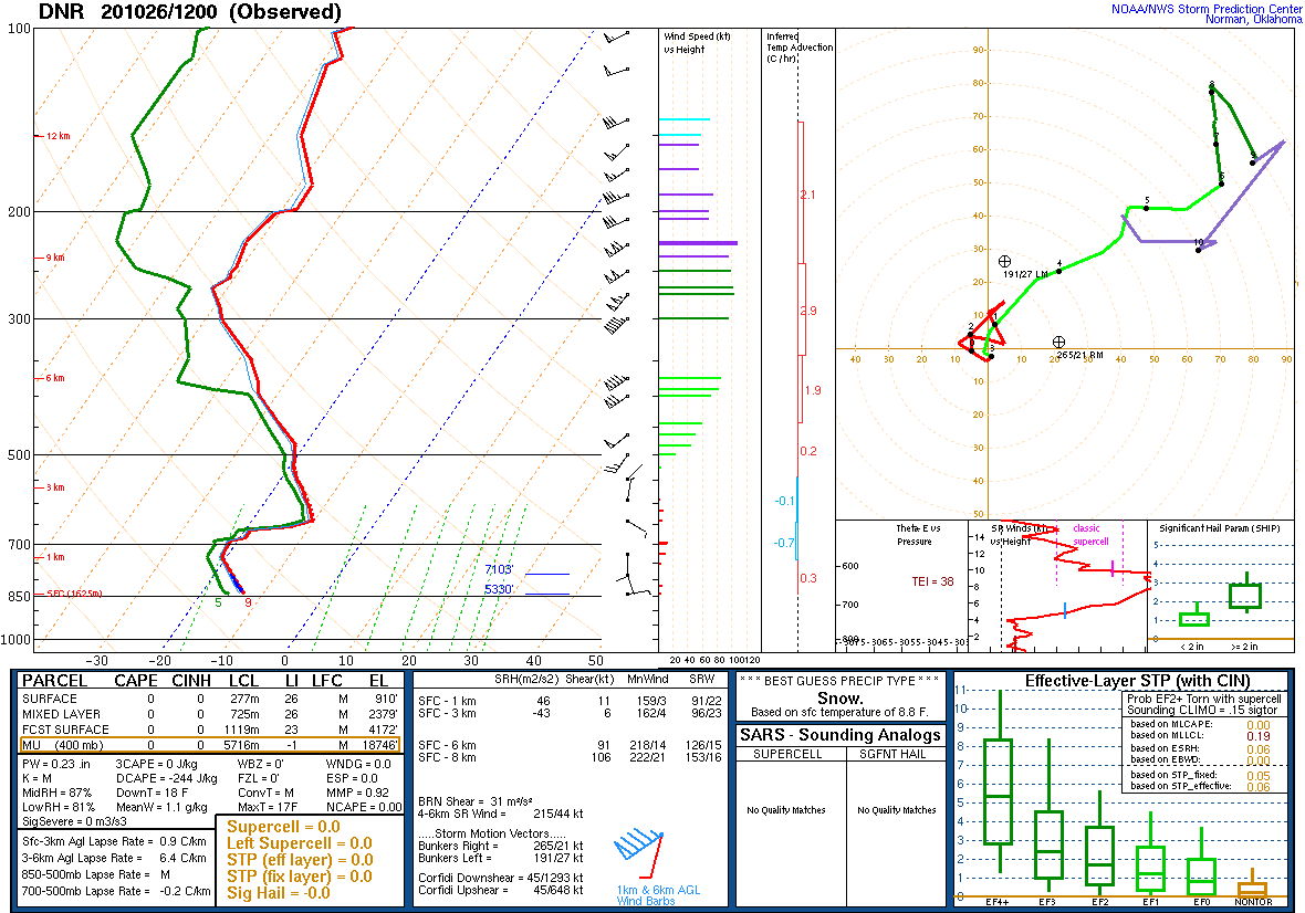 |
| Figure 6: Denver sounding released at 6:00 PM Saturday, October 24th. Note the cold front has not yet reached Denver. | Figure 7: Denver sounding released 6:00 AM Sunday, October 25th. Note the much colder temperatures at the surface, as well as an increase in moisture. | Figure 8: Denver sounding released 6:00 PM Sunday, October 25th. | Figure 9: Denver sounding released 6:00 AM, Monday, October 26th. |
 |
Media use of NWS Web News Stories is encouraged! Please acknowledge the NWS as the source of any news information accessed from this site. |
|

