The National Weather Service (NWS) provides weather, hydrologic, and climate forecasts and warnings for the United States, its territories, adjacent waters and ocean areas, for the protection of life and property and the enhancement of the national economy. NWS data and products form a national information database and infrastructure which can be used by other governmental agencies, the private sector, the public, and the global community.
In support of this NWS mission, the Alaska-Pacific River Forecast Center (APRFC) produces timely and accurate water forecasts and information using the best available scientific principles to integrate and model water, weather, and climate information. Our highly-motivated, customer-focused staff is dedicated to professionalism, innovation, and fulfilling expectations of our customers and partners.
APRFC Vision Statement: " Keeping a Watch Over Alaska's Waterways "
Flood Facts:
The objectives of the hydrologic service program of the National Weather Service are:
There are two levels to the hydrologic services offered by the NWS. The River Forecast Center (RFC) is staffed by professional hydrologists and hydrometeorlogists who issue river, reservoir and flood forecasts using computer models for predictions. The RFC staff provides forecast guidance to personnel at the NWS Weather Forecast Offices (WFOs), who in turn issue forecasts, outlooks and related hydrologic information to the media, public and water resource managers.
Flood and high water forecasting is our most important and highest profile duty. Millions of dollars and countless lives are saved each year nation-wide from timely and accurate predictions of both flood crests and flood duration. Industries dependent upon a river for water also rely on river stage forecasts. Besides the obvious need for flood forecasts, some riverside industries are required to adjust their operations, such as water intake, based on the river levels. Hydroelectric plant operators need to know how much water is coming into their reservoir in order to properly maintain the water level for maximum power generation. Water supply forecasting is also important, since increasing population, conflicting needs for water, and drought conditions have necessitated a growing need for water management. Many types of aquatic recreation can be affected by river and stream levels. Boaters may not be able to use a river if the water is too high or too low. Anglers will change their techniques or catch based on stream levels.
The National Weather Service's River and Flood Program traces its origins back to the start of the National Weather Service itself. In 1870, Congress authorized the Army Signal Service Corps to create a river and stream gauge program, as well as a weather observation and forecasting program. Then, Congress passed the Organic Act of 1890, that transferred all weather and related river services into the Department of Agriculture, and created a civilian U.S. Weather Bureau, which would later become the National Weather Service (NWS).
As the country grew, the need for expanded hydrologic services grew with it. In 1903, an extensive and disastrous flood struck the Kansas River, further raising public cries for improved flood forecasting. In response, Congress passed legislation making river and flood services a separate division within the Weather Bureau. Starting with the Kansas River, expanded hydrologic services moved into Texas and then throughout the entire country within the next few years.
With the nation's continued growth, the economy became increasingly dependent on river and flood forecasting, but the emphasis still remained on protection of life and property. In 1940, the Weather Bureau was transferred into its present home, the Department of Commerce, and a river division, known as the the NWS Office of Hydrology, was formed. This river division divided the country into river districts, each with an associated Weather Bureau office to cater to the hydrologic needs of that area. By the the end of World War II, the increasing responsibilities of the regular Weather Bureau offices prompted the need for separate River District Offices. Finally, through the 1960's these offices combined into the 13 River Forecast Centers that exist today.
The National Weather Service (NWS) is the operational weather services component of the National Oceanic and Atmospheric Administration (NOAA), an agency of the United States Department of Commerce. The National Weather Service authority as the U.S. Government entity responsible for providing flood forecast services is established in Article 1 of the Constitution, the "Organic Act" of 1890 (15 USC 313) and the "Flood Control Act" of 1938 (33 USC 706). NWS has 122 Weather Forecast Offices (WFOs), 13 River Forecast Centers (RFCs), and 5 National Centers for environmental Prediction (NCEP) (as of Feb 2003). These field offices are administratively and technically supported by Regional and National headquarters.
The Alaska-Pacific River Forecast Center (APRFC) is part of the National Weather Service's Alaska Region. APRFC provides operational hydrologic services for three Weather Forecast Offices located in Anchorage, Fairbanks, and Juneau. Operational products generated by the APRFC include flood forecasts, general river forecasts, recreational forecasts, navigation forecasts, reservoir inflow forecasts, water supply outlooks, spring flood outlooks, and various types of flash flood guidance. APRFC also provide hydrologic development support for both the Alaska and Pacific Regions. This includes a variety of other services, such as developing and implementing new procedures, forecast techniques, computer systems, data handling techniques, and hydrologic-related hardware. The APRFC also provides hydrologic expertise on a wide range of hydrologic activities for NWS and other federal, state, and local agencies. Click here for a more detailed history of the APRFC.
The eleven-person staff of the APRFC consists of one Hydrologist-in-Charge, one Development and Operations Hydrologist, two senior hydrologists, two hydrologists, one senior hydrometeorologist, two hydrometeorologists, one hydrotechnician and an Information Technology Officer.
NWS River Forecast Centers have four basic functions:
Primary operational duties include hydrologic forecasting, hydrometeorologic analysis and support (HAS) functions and the monitoring/quality control of associated data sets which are input/output to/from operational computer models.
The hydrologic forecaster is responsible for the daily production of river forecasts, flash flood guidance, data summary products, execution of the river forecast computer model and coordination of river forecasts as required. The HAS forecaster is responsible for preparing the observed and forecast precipitation and temperature input for the river forecast model, the Hydrometeorologic Discussion product and the coordination with and support of the hydrologic forecaster and the NWS Weather Forecast Offices (WFOs).
Other operational functions are performed on a seasonal or as needed basis. These functions include production of water supply forecasts, flood outlooks and drought summaries.
When we're not making forecasts on rivers, we use the time to refine our procedures, to make our computer models better, and try to improve our methods for forecasting so when major flooding does occur, we're ready for it. Some of our current projects include:
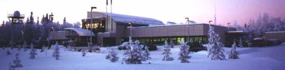
The APRFC office is located in Anchorage south of the Ted Stevens International Airport and is co-located with the Anchorage Weather Forecast Office, Alaska Aviation Weather Unit, Anchorage Electronics Unit, and Alaska Facilities Unit.
The mailing address is:
Alaska-Pacific River Forecast Center
6930 Sand Lake Road
Anchorage, Alaska 99502-1845
Telephone: 907-266-5160
Fax: 907-266-5182
email: nws.ar.aprfc.webauthors@noaa.gov

