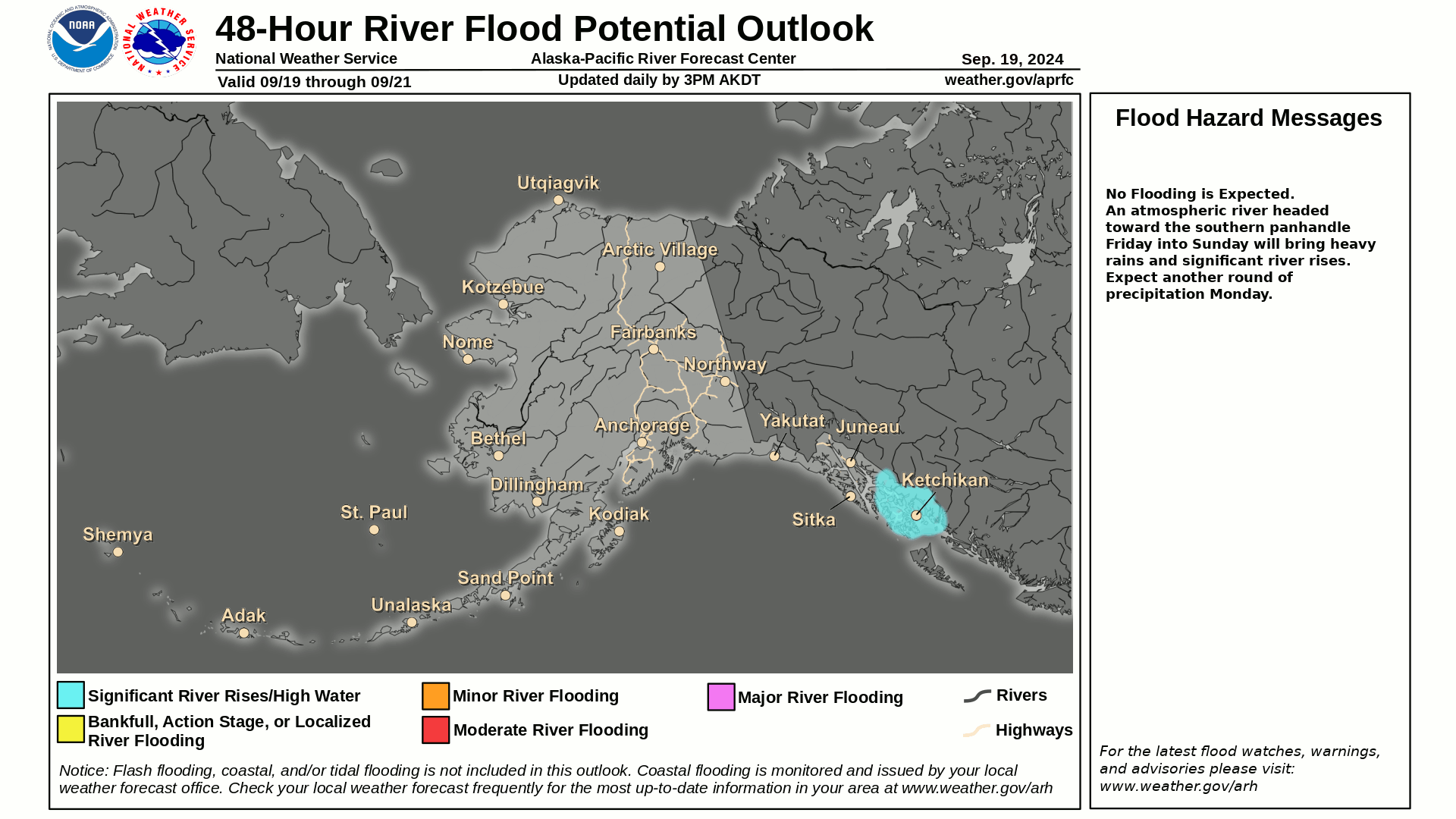
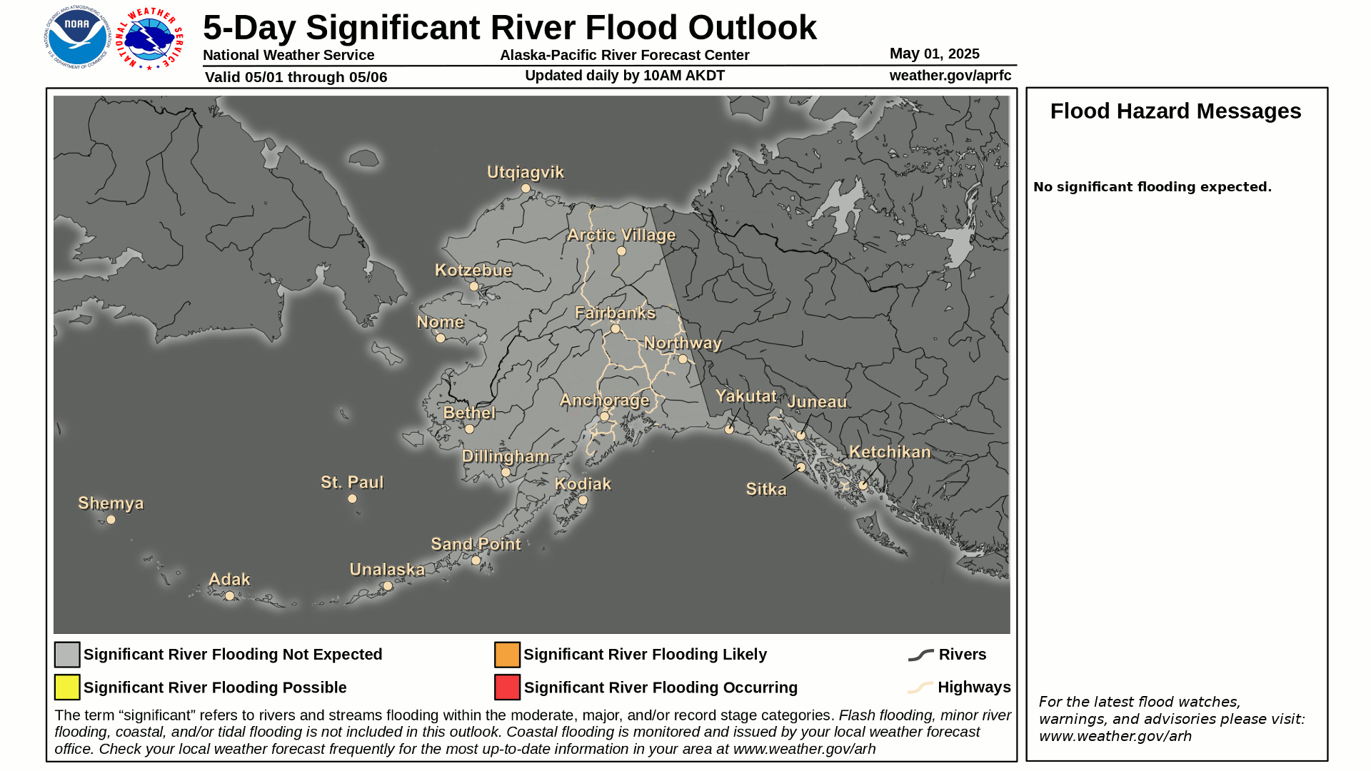
Flood Outlook
Current Conditions
|
|
|
|
|
Current Vis/IR Loop (click for loop)
|
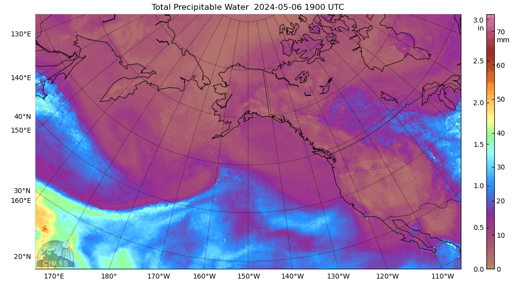
Total Precipitable Water Loop
|
|
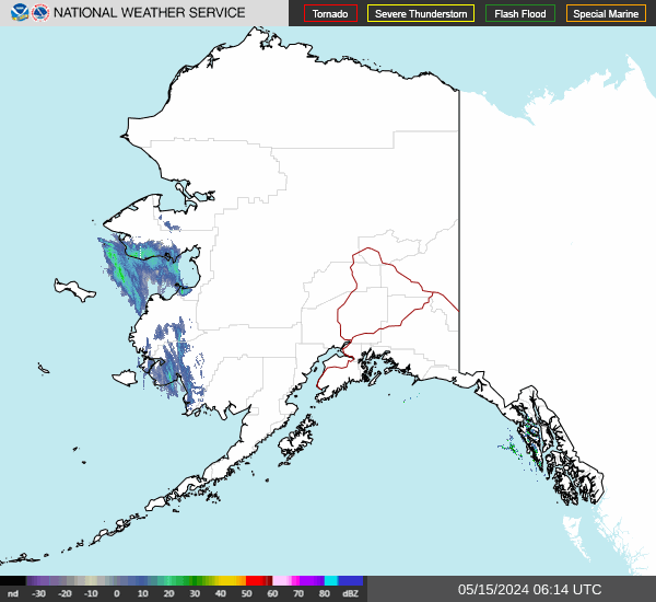
Alaska Mosaic Radar Loop
|
|
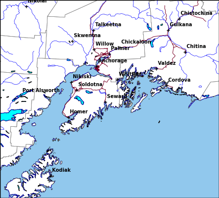
Kenai Radar Loop
|
Middleton Radar Loop
|
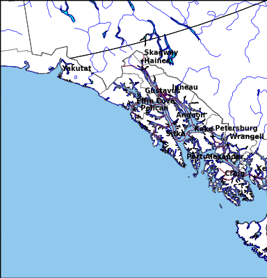
Sitka Radar Radar Loop
|
|
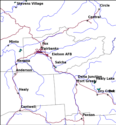
Fairbanks Radar Loop
|
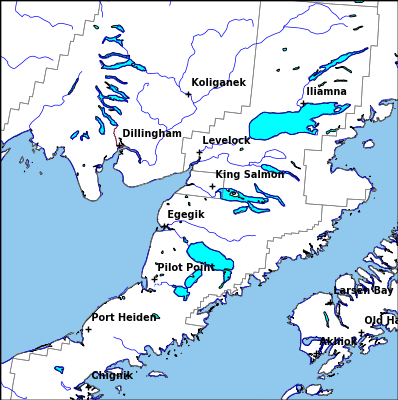
King Salmon Radar Loop
|
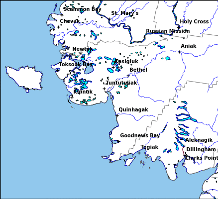
Bethel Radar Loop
|
|
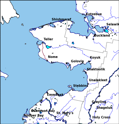
Nome Radar Loop
|
Observed Precipitation
|
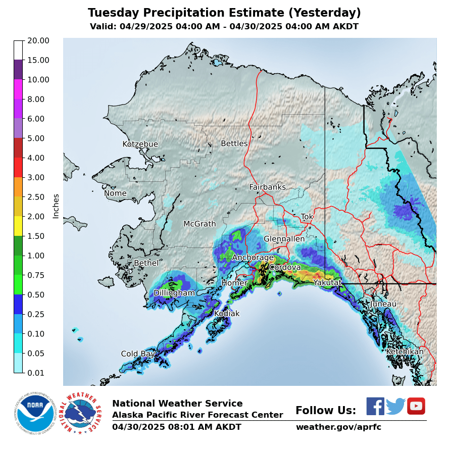
Yesterday
|
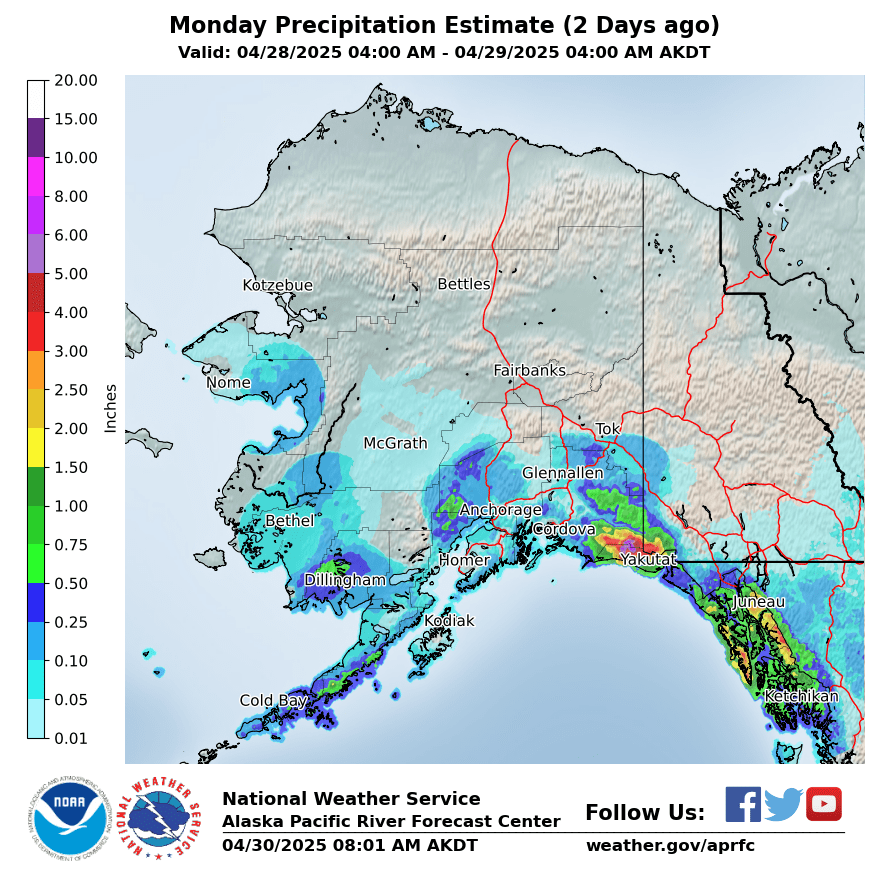
2 Days Ago
|
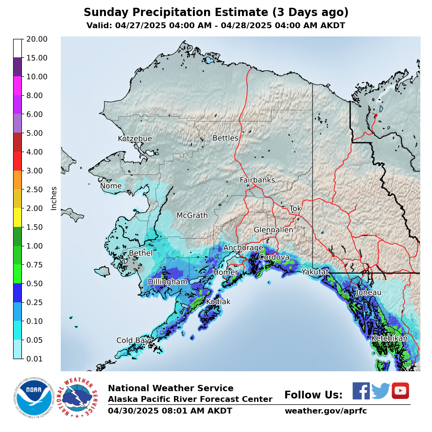
3 Days Ago
|
|
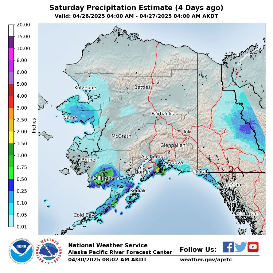
4 Days Ago
|
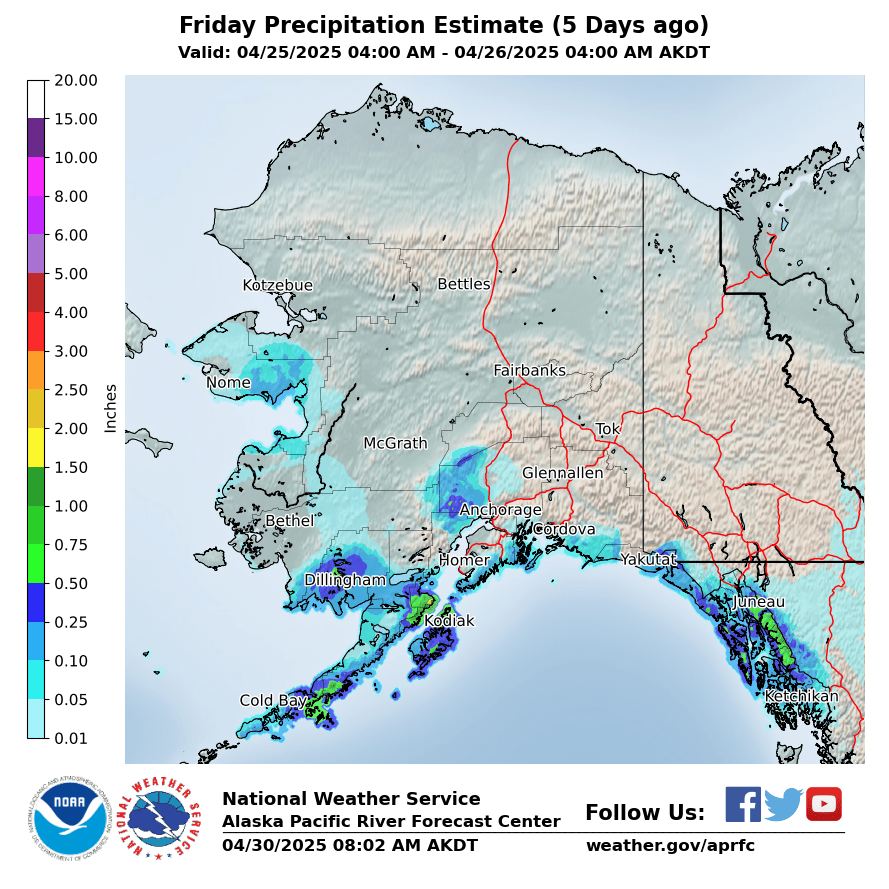
5 Days Ago
|
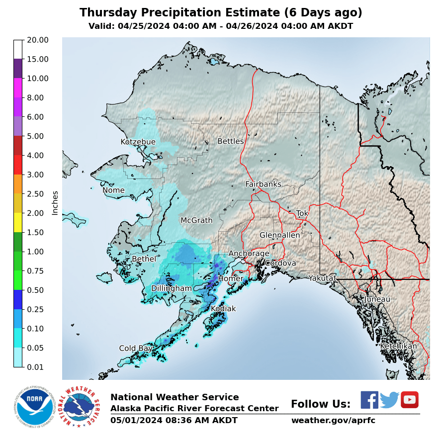
6 Days Ago
|
|
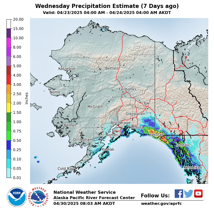
7 Days Ago
|
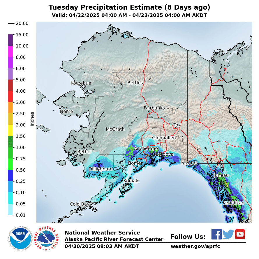
8 Days Ago
|
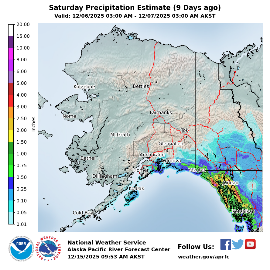
9 Days Ago
|
|
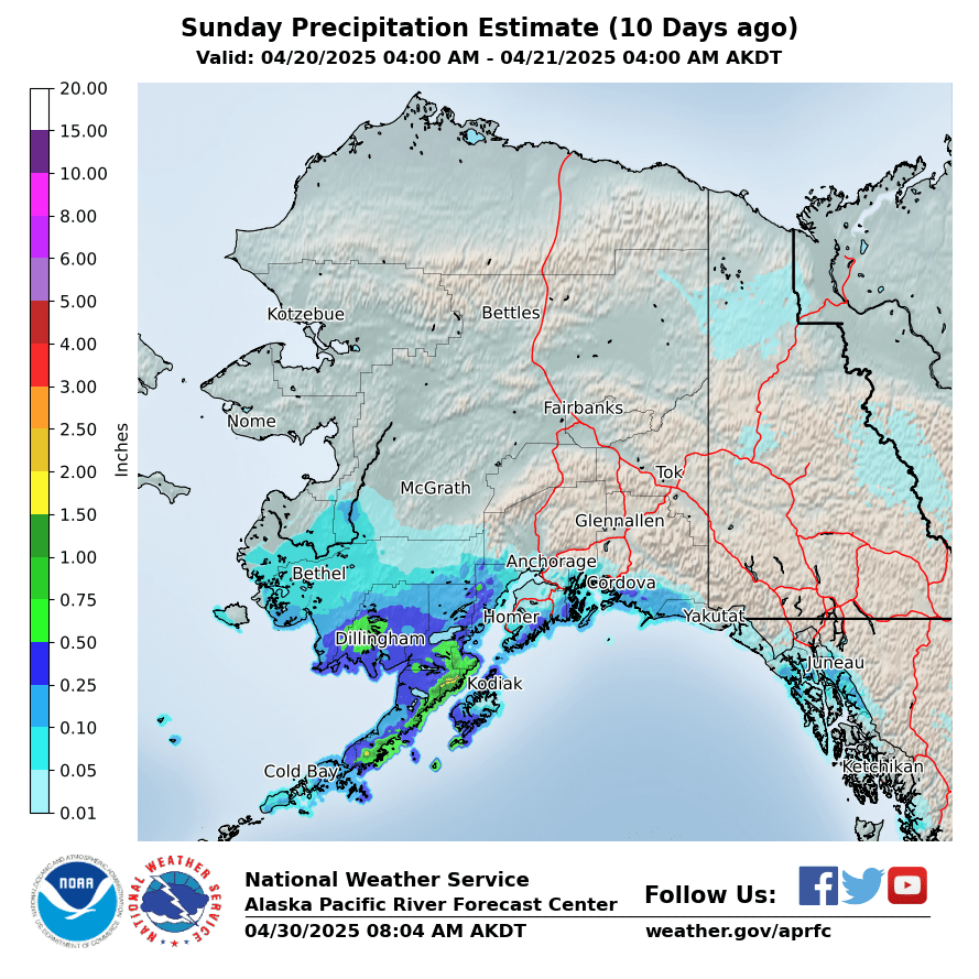
10 Days Ago
|
Forecasted Precipitation
|
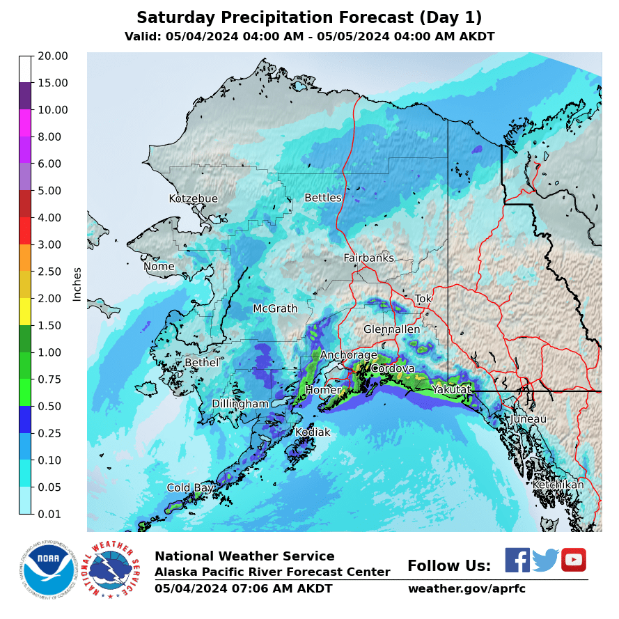
Day 1
|
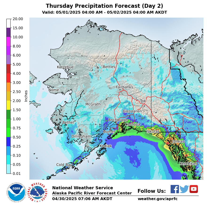
Day 2
|
Day 3
|
|
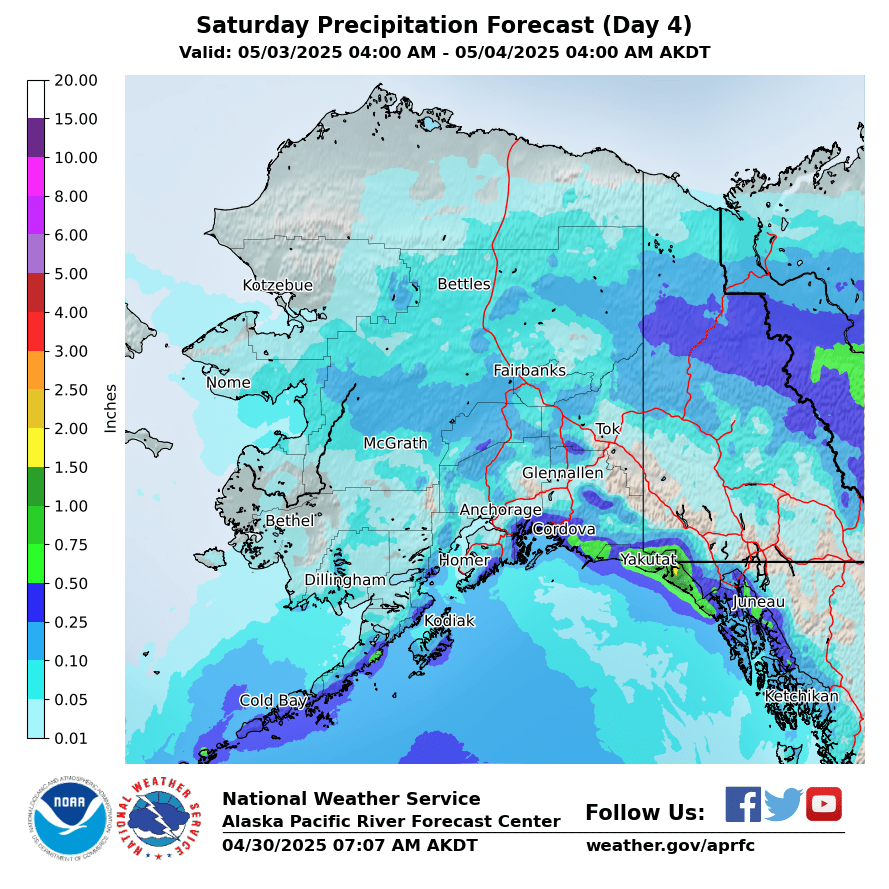
Day 4
|
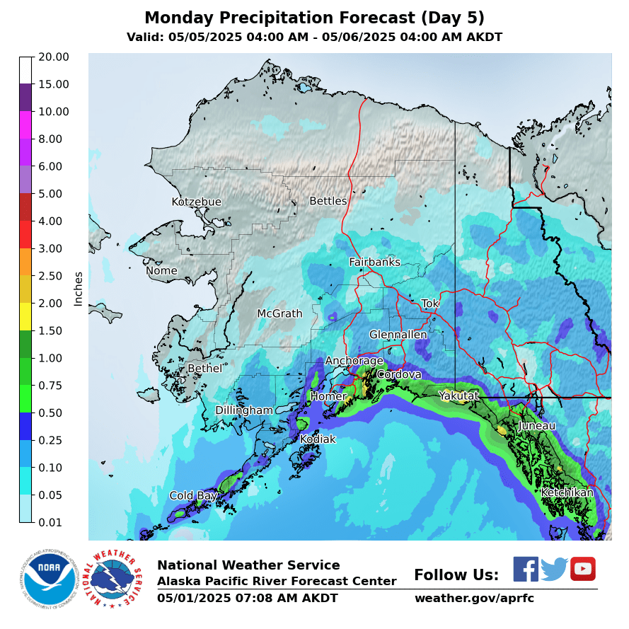
Day 5
|
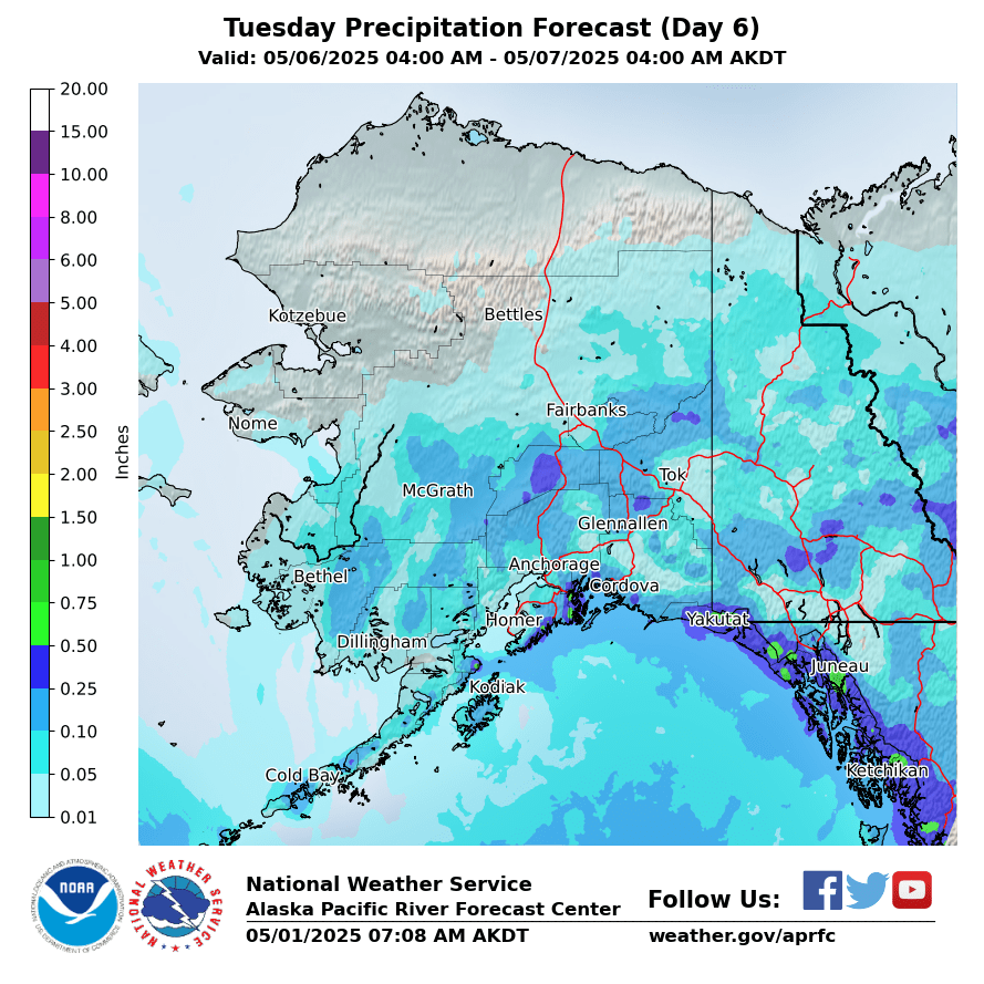
Day 6
|
|
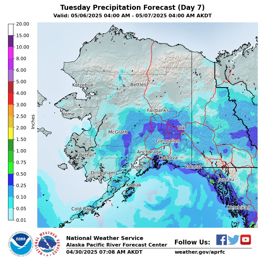
Day 7
|
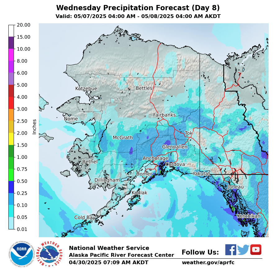
Day 8
|
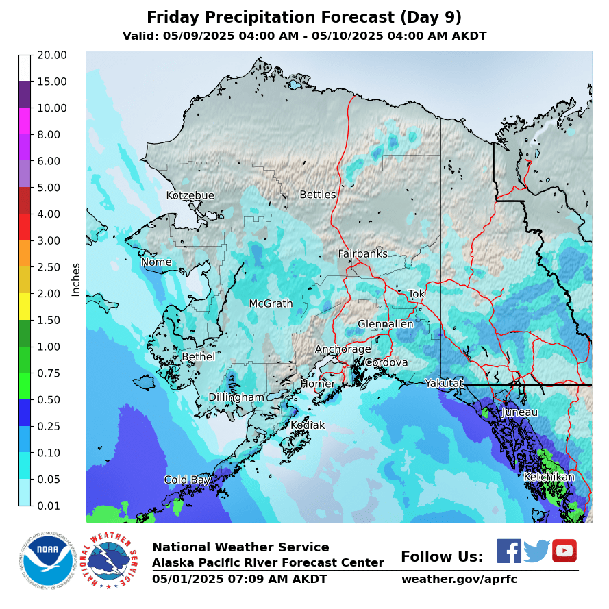
Day 9
|
|
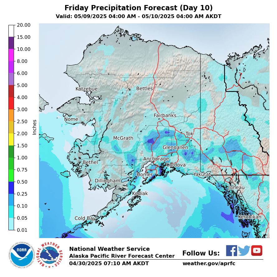
Day 10
|
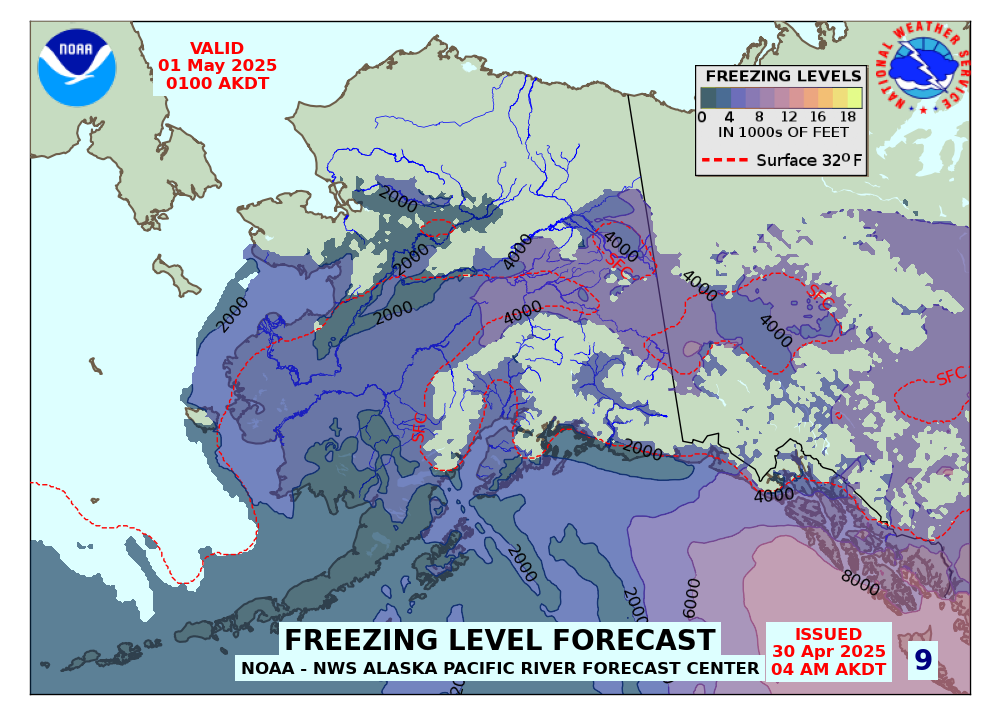
Forecasted Freezing Levels (click for Loop)
|
|
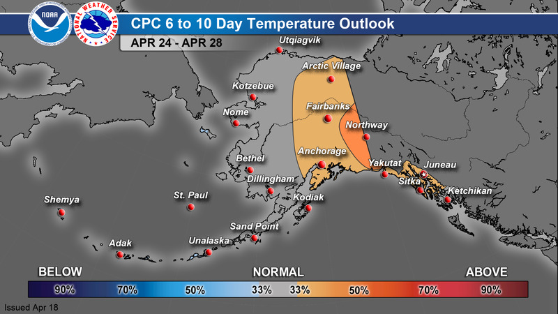
CPC 6-10 Day Outlook
|
Temperature
|
Precipitation
|
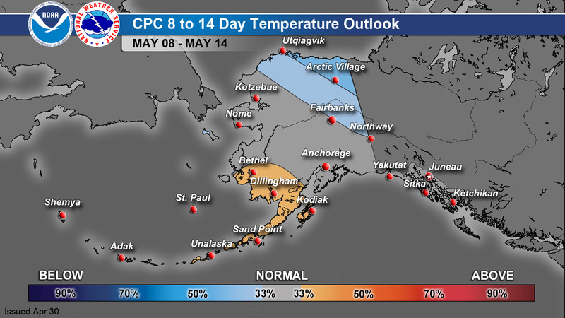
CPC 8-14 Day Outlook
|
Temperature
|
Precipitation
|
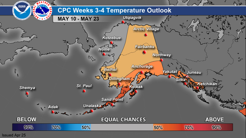
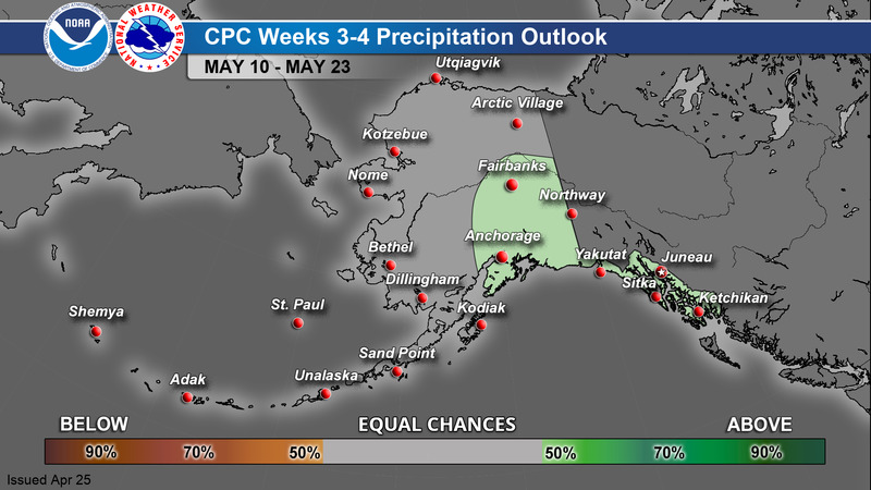
CPC Week 3-4 Outlook
|
Temperature
|
Precipitation
|
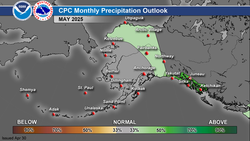
CPC 1 Month Outlook
|
Temperature
|
Precipitation
|
>
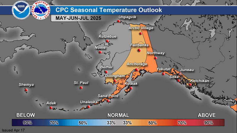
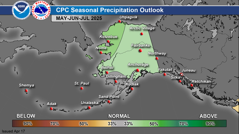
CPC 3 Month Outlook
|
Temperature
|
Precipitation
|
For additional climate outlook data, see: https://www.cpc.ncep.noaa.gov/
A Guide to Interpreting CPC Products: https://www.weather.gov/afc/GuideToInterpretCPCProducts
Alaska Drought Monitor
|
|
000
FXAK68 PAFC 011339
AFDAFC
Southcentral and Southwest Alaska Forecast Discussion
National Weather Service Anchorage AK
539 AM AKDT Wed May 1 2024
.SHORT TERM FORECAST SOUTHCENTRAL ALASKA (Days 1 through 3: Today
through Friday night)...
Another cloudy and otherwise seasonable day is on deck for much of
southcentral Alaska. GOES satellite imagery shows a large upper-
level low currently across the eastern Aleutians near the Alaska
Peninsula, with an associated front stretching from the north
Pacific into the AK Peninsula close to Kodiak Island. Meanwhile,
ridging exists across northern BC into YT and into eastern
southcentral Alaska. Radar imagery shows showery activity across the
Gulf of Alaska and into the Kenai Peninsula northward into the
Susitna Valley.
Shower activity will continue through the morning and through at
least the first half of the day as shortwave energy moves across
marginally unstable air in the lower atmosphere. Precipitation
amounts will generally be light and spotty through the Kenai
Peninsula up through Mat-Su Valley. Southeast gap winds will
increase today in response to a strengthening pressure gradient with
the approach of the aforementioned front. Gusts of 25 to 35 mph are
not out of the question across Turnagain Arm, West Anchorage and the
Hillside, the Kink River Valley, and the Copper River Valley.
Rain will be near continuous for Kodiak Island from later this
afternoon through much of Thursday. Rainfall amounts in Kodiak City
should be near an inch, with higher amounts in the mountains. The
same frontal system will bring rain to the southern and coastal
Kenai Peninsula into the PWS Thursday into Friday, with downsloping
easterly flow keeping the west side of the Peninsula and Anchorage
largely dry.
-Brown
&&
.SHORT TERM FORECAST SOUTHWEST ALASKA (Days 1 through 3: Today
through Friday night)...
A weakening low in the southern Bering Sea extends an occluded
front across the Alaska Peninsula this morning, where it is
bringing rain and gusty southeasterly winds. Ahead of the front,
weak shortwaves lifting across Southwest Alaska are producing
light rain with isolated to scattered showers. Southeasterly winds
will increase this morning as the front pushes north into
Southwest Alaska, reaching the northern Bristol Bay coast by this
afternoon. Models are increasingly dry with this front, and the
southeasterly downslope flow will act to suppress most shower
activity. Rain will be most likely along the front near Dillingham
today, however, some isolated showers will be possible elsewhere,
with scattered showers most likely in the Lower Kuskokwim Valley
this afternoon/evening. Precipitation will wane across Southwest
Alaska heading into Thursday as the front slowly lifts north and
continues to weaken.
Out west, a low tracks into the western Bering Sea, its front
pushing into the western Aleutians this evening with rain and gale
force easterly winds. The front pushes quickly north and east,
reaching the Pribilof Islands and the southern tip of the Alaska
Peninsula by Thursday night. A few inches of snow is possible for
the Saint Paul and Saint George as the front lifts north through
Friday. As the front lifts toward Southwest Alaska, accompanying
upper-level troughing moving into the area promotes increasingly
wetter conditions for the end of the week.
CQ
&&
.LONG TERM FORECAST (Days 4 through 7: Saturday through Tuesday)...
A weakening upper level ridge slips towards the Arctic Coast and
recedes into Canada through the forecast period. A very broad
upper level trough stretches from the Russian Far East across the
Bering and Alaska Peninsula and Gulf of Alaska. This trough is
well supported by an elongated jet along the Aleutians into the
Gulf throughout the weekend, while the body of the trough persists
over the Northern Bering. Ensemble means maintain good confidence
through Tuesday. A well clustered upper low entering Bristol Bay
Saturday moves into the Gulf of Alaska for Monday before shifting
to the upper Southeast Panhandle by the end of the period. This
low will also initiate moderate cold air along the Alaskan West
Coast and bring somewhat below normal surface temperatures across
Western Alaska.
The main low brings gusty Westerly winds along the Aleutians and
AKPEN, with a second wind area moving along the West Coast from
the North through Sunday. A large area of rainfall spreads across
the Aleutians and Bering across Southwest and Southcentral Alaska,
with locally heavier amounts expected across Southcentral zones
through Tuesday. Another round of widespread precipitations moves
over the Western Aleutians and Bering on Sunday and moves East
through Tuesday.
- Kutz
&&
.AVIATION...
PANC...VFR conditions will persist through the TAF period.
Southeasterly Turnagain Arm winds are expected to pick up again
this afternoon before diminishing tonight. Winds thereafter should
remain light out of the north.
&&
$$
000
FXAK69 PAFG 302156
AFDAFG
Northern Alaska Forecast Discussion
National Weather Service Fairbanks AK
156 PM AKDT Tue Apr 30 2024
.SYNOPSIS...
Overall upper-level pattern this afternoon is showing a trough
moving into the Gulf of Alaska with a larger trough moving into the
western Bering Sea. At the same time, ridging continues aloft over
the eastern Bering Sea. Models are in good agreement at least
through Thursday showing the upper trough over the Bearing Sea
moving eastward towards the Alaska Peninsula and eventually into the
Gulf of Alaska by Thursday afternoon. Weak energy continues to lift
into the Interior Alaska today and is evident on both satellite and
radar imagery. We have seen pretty consistent returns on radar
across the White Mountains this morning, however, there remains some
uncertainty on how much is actually reaching the ground. As the
aforementioned low reaches the Gulf of Alaska, we will see increased
southerly flow through the Alaska Range that will bring Chinook
winds that will lead to some elevated fire weather concerns on
Thursday and continuing into the weekend. This southerly flow will
actually be reinforced by another strong upper-level trough that
moves through the Bering Sea and into the Alaska Peninsula into the
weekend.
&&
.DISCUSSION...
Isolated showers will continue through the remainder of the day
today and continue into Wednesday across the interior. Despite the
chances, overall QPF amounts will remain low. There is also a chance
that as temperatures cool this evening and through the night that we
could see some snow from Galena through Tanana and then into the
White Mountains. Also can`t guarantee that a few flakes are not seen
from McGrath through Fairbanks. As southerly flow increases with the
passing of the two aforementioned upper-level troughs, we will see
some increasing Chinook winds along the northern slopes of the
Alaska Range. Because of this, wind prone areas will see wind gusts
increasing to around 30 to 50 mph, especially into the weekend. With
lower daytime humidity values, this will lead to some elevated fire
weather conditions from Thursday and only increasing into the
weekend. This will also allow for some sort of WAA for the interior
that will bring above average high temperatures.
An Arctic cold front will generally continue to impact the North
Slope through late week. This will lead to cooler than normal
temperatures across the northern slope into the weekend. We will
also see periods of light snow, fog, and low stratus through at
least Friday. Winds will begin to increase as we head into the
weekend, with gusts up to around 30 mph that will likely bring more
periods of blowing snow.
High pressure currently over the Yukon Delta will become less of an
influence as it pushes to the southeast through Wednesday. By this
time, the first upper-level trough will be in the Gulf of Alaska,
wrapping around moisture by Wednesday afternoon. It should be cold
enough that the coastal areas will see some snow while inland areas
will see periods of rain. Again, any accumulations for this area
will remain light. Still looking like a brief lull in the
precipitation for Thursday before the second upper-level trough
moves into the Gulf of Alaska that will bring another round of what
looks to be more widespread showers to the West Coast on Friday and
into Saturday. There remains some uncertainty on the timing of this
secondary precipitation as it highly depends on the track of the
second trough along with how fast it pushes east. As with the
remainder of the area, winds will also be on the increase as we move
into the weekend for the West Coast.
Coastal Hazard Potential Days 3 and 4...None.
&&
.FIRE WEATHER...
Min RH values across the Upper Tanana Valley today have
generally ranged from around 15 to 25 percent with the rest of the
interior between the 25 to 40 percent range. Aside from the southern
portion of the Lisburne Peninsula, the North Slope and West Coast
have seen ranges from the 50 to 80 percent range. Similar conditions
will be seen on Wednesday in terms of min RH values, with maybe some
lowering RH across the Upper Tanana Valley into the Delta Junction
and areas to the south of here. By Thursday, min RH values from
Fairbanks into the Delta Junction and the Eastern Alaska Range and
the Upper Tanana Valley will be in the 15 to 20 percent range.
Mixing this with increasing southerly winds through the Alaska Range
passes fire weather concerns will increase. Looks like moderate
Chinook winds will develop as early as Thursday afternoon,
increasing as we move into Friday and then continuing into the
weekend. Wind gusts of 30 to 50 mph and lower humidity values will
be very near Red Flag conditions for the aforementioned areas.
&&
.HYDROLOGY...
An ice jam on the Yukon River just upstream of Eagle,
along with some ice remaining in place at Eagle, have lead to an Ice
Jam Flood Watch for Eagle. River watch teams are in the air today
and will get more information. We will continue to monitor and
update as needed.
&&
.AFG WATCHES/WARNINGS/ADVISORIES...
AK...Flood Watch for AKZ835.
PK...Small Craft Advisory for PKZ802.
Brisk Wind Advisory for PKZ805.
Brisk Wind Advisory for PKZ806-807-850.
Brisk Wind Advisory for PKZ809.
Brisk Wind Advisory for PKZ810-854-856.
Gale Warning for PKZ811.
Brisk Wind Advisory for PKZ812-817-851-858.
Heavy Freezing Spray Warning for PKZ816.
Small Craft Advisory for PKZ816.
Brisk Wind Advisory for PKZ852.
Brisk Wind Advisory for PKZ853.
Brisk Wind Advisory for PKZ857.
&&
$$
BT
000
FXAK67 PAJK 011225
AFDAJK
Southeast Alaska Forecast Discussion
National Weather Service Juneau AK
425 AM AKDT Wed May 1 2024
.SHORT TERM.../Through Wednesday night/ Rather quiet short range
forecast today. Winds are for the most part light and are expected
to stay that way across the panhandle. The only exceptions are the
usual sea breeze areas in the afternoon where winds could reach 15
mph. Slightly different story out in the central gulf where an
area of low pressure moving up from the S will bring increasing SE
winds to 25 kt to the offshore area tonight.
Otherwise the only other concern is cloud cover which is mainly
affecting the gulf, the southern panhandle and the NE gulf coast
this morning. Expect clouds to gradually diminish through the day
with skies generally staying clear tonight as low level flow turns
more offshore across the area. Expect slightly warmer highs today
then yesterday as a result (mid 50s) while low temperatures
tonight will likely fall into the low 30s (north) to low 40s
(south) due to the clearer skies.
.LONG TERM.../ Thursday to Sunday night / Weak high pressure over the
eastern gulf and panhandle are holding in place through Friday. A
short wave will move from the southwestern gulf across the
southern gulf and southeast towards the Pacific Northwest by
Friday morning. A larger low moves into the Bering Sea Friday and
Saturday while drifting east. The associated frontal will move
into the panhandle area Saturday, with main panhandle more later
half of Saturday.
Am not expecting any winds over 20 kt until the weekend time frame
and those will be starting over the outer gulf waters. &&
.AVIATION...MVFR or VFR conditions continue this morning with a
marine layer covering the southern portions of the panhandle as
well as the NE gulf coast. This layer will persist through the
morning before breaking up during the day with more daytime
heating. As high pressure moves inland during the latter half of
the TAF period, this marine layer is expected to dissipate even
more as more offshore flow develops allowing for clearing skies.
Otherwise, flying should remain really good overall for the TAF
period.
&&
.AJK WATCHES/WARNINGS/ADVISORIES...
PUBLIC...None.
MARINE...None.
&&
$$
SHORT TERM...EAL
LONG TERM....Bezenek
AVIATION...SF
Visit us at http://www.weather.gov/Juneau