 |
| About This Page |
| Arkansas has had its share of historic events, many of which will be in our memories for years to come. |
|
|
 |
Drought in 2012 |
 |
| |
|
|
It was a bad combination of very little rain and warmer than normal temperatures from April through July. |
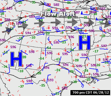
| In the picture: The pattern on 06/28/2012 featured a large area of high pressure ("H") over the southern United States, with the main flow aloft (and storm systems) forced well to the north. |
| During this four month period, six to twelve inch rainfall deficits were common (thirty to sixty percent of normal rainfall). It was the driest April through July on record. |
| Precipitation (April Through July, 2012) |
| Site |
Amount |
Normal |
+/- |
% of Normal |
| Fayetteville (NW AR) |
7.91 |
19.05 |
-11.14 |
41% |
| Harrison (NC AR) |
6.40 |
16.39 |
-9.99 |
39% |
| Jonesboro (NE AR) |
5.67 |
16.92 |
-11.25 |
34% |
| Fort Smith (WC AR) |
9.62 |
17.35 |
-7.73 |
55% |
| Little Rock (C AR) |
6.43 |
16.93 |
-10.50 |
38% |
| West Memphis (EC AR) |
12.29 |
18.18 |
-5.89 |
68% |
| Texarkana (SW AR) |
9.18 |
16.92 |
-7.74 |
54% |
| El Dorado (SC AR) |
7.98 |
17.60 |
-9.62 |
45% |
| Pine Bluff (SE AR) |
10.11 |
17.49 |
-7.38 |
58% |
| Driest April Through July Periods in Arkansas |
| Year |
Amount |
| 2012 |
9.03" |
| 1896 |
10.75" |
| 1901 |
10.78" |
| 1926 |
11.30" |
| 1936 |
11.62" |
| 1925 |
11.68" |
| 1914 |
11.70" |
| 1934 |
11.71" |
| 1998 |
11.96" |
| 1988 |
12.13" |
|
Breaking it down, the drying out process started in northeast Arkansas in April. There was less than an inch of rain in some areas. Blytheville (Mississippi County) had 0.82 inch, with 0.97 inch at Greers Ferry Lake (Cleburne County) and 0.99 inch at Batesville Lock and Dam (Independence County). Soil moisture along the Mississippi River dropped below normal, and there was a growing concern about a developing drought.
That concern magnified in May as precipitation become more spotty. It was a record dry May in parts of western Arkansas. Gilbert (Searcy County) had no rain at all, with 0.01 inch at Ozark (Franklin County), 0.09 inch at Morrilton (Conway County) and 0.11 inch at Dardanelle (Yell County).
|
|
Not much changed in June. There was less than two inches of precipitation at most locales. Only 0.14 inch was tallied near Beedeville (Jackson County), with 0.23 inch just northeast of Damascus (Van Buren County) and 0.48 inch at the Clarksville Water Plant (Johnson County). It was the driest June on record at these sites. At the latter site, records date back to 1871!
|
|
Late in June, a ridge of high pressure (common summertime feature) built over much of the country. This resulted in record heat.
|
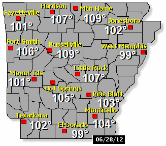 |
| In the picture: High temperatures on 06/28/2012. |
|
On the 28th, the mercury topped out at 109 degrees at Mountain Home (Baxter County), Russellville (Pope County) and Searcy (White County). All-time record high temperatures for June were set at Harrison (Boone County) and Little Rock (Pulaski County). It was 107 degrees at both places.
Interestingly, it was just about the hottest June afternoon ever a few days earlier (on the 25th), with several monthly heat records snapped. Those records were met or exceeded.
|
|
The heat continued in July. On the 20th, it was particularly hot in the Arkansas River Valley from Little Rock (Pulaski County) westward, and also in the Ouachita Mountains. There were many readings above 105 degrees. The temperature soared to 111 degrees at Little Rock (Pulaski County) on the 30th, the third highest reading ever recorded locally.
|
| Temperatures Reaching the Century Mark in June/July, 2012 |
| Site |
Days >= 100° |
Days >= 105° |
Highest |
| Fayetteville (NW AR) |
12 |
0 |
104° |
| Harrison (NC AR) |
17 |
2 |
107° |
| Mtn Home (NC AR) |
23 |
5 |
109° |
| Jonesboro (NE AR) |
14 |
1 |
105° |
| Fort Smith (WC AR) |
27 |
10 |
108° |
| Russellville (WC AR) |
30 |
14 |
109° |
| Mount Ida (WC AR) |
14 |
2 |
107° |
| Hot Springs (C AR) |
20 |
9 |
109° |
| Little Rock (C AR) |
21 |
9 |
111° |
| West Memphis (EC AR) |
2 |
0 |
101° |
| Texarkana (SW AR) |
12 |
1 |
107° |
| El Dorado (SC AR) |
7 |
0 |
104° |
| Pine Bluff (SE AR) |
12 |
1 |
105° |
| Monticello (SE AR) |
10 |
2 |
106° |
|
The average temperature in Arkansas during the first seven months of the year was 64.57 degrees. This was more than a degree higher than any other year on record. The last year with a reading over 63 degrees was 1925!
|
| Warmest January Through July Periods in Arkansas |
| Year |
Avg. Temperature |
| 2012 |
64.57° |
| 1921 |
63.19° |
| 1925 |
63.13° |
| 1911 |
62.97° |
| 1986 |
62.71° |
| 1938 |
62.67° |
| 1932 |
62.57° |
| 1927 |
62.54° |
| 1998 |
62.44° |
| 1954 |
62.37° |
|
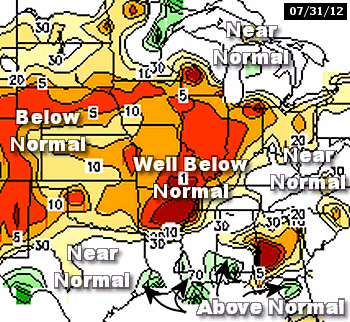
As of July 31st, a flash (rapidly developing and intense) drought affected much of the state with severe to exceptional drought conditions.
|
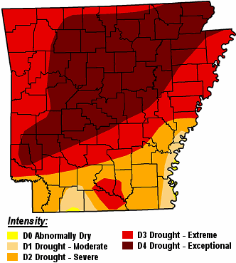 |
| How bad was it? The region had the highest percent of its total area in exceptional drought (D4) of any state in the country. |
| |
| Drought Conditions (Percent Area) |
| Category |
Coverage |
| D0-D4 |
100% |
| D1-D4 |
99.66% |
| D2-D4 |
96.12% |
| D3-D4 |
80.63% |
| D4 |
44.46% |
|
| In the picture: A severe to exceptional drought was noted in much of Arkansas on 07/31/2012. |
|
On July 11th, the United States Department of Agriculture (USDA) designated 69 of 75 Arkansas counties as disaster areas to help farmers recover from losses caused by the drought. That was bumped to 72 counties (all but Chicot, Desha and Drew Counties) by August 8th. Nationwide, the drought encompassed almost 1,500 counties in 33 states. This was more than half the country, making this the most far reaching drought since the mid 1950s.
A drought emergency was declared in Arkansas on August 3rd by Governor Mike Beebe. Hay was in short supply, and was expensive to buy. Many ranchers were forced to sell cattle early. The goal of the declaration was to make hay more readily available to ranchers whose feed supply was critically low.
|
| The Cost of the Drought |
|
According to a study by the University of Arkansas Division of Agriculture, ranchers in Arkansas lost at least $128 million due to drought conditions from August, 2011 through July, 2012. The losses were mostly the result of a short supply of hay and rising hay costs. It became too expensive to feed cattle, and ranchers were forced to sell their cows.
At one time, 85% of pastures were in poor or very poor condition. This led to lackluster hay production and the smallest hay yields since the mid 1950s. While shipping hay from surrounding areas was an option, red fire ants complicated the process. Many hay growers in the southeast United States live in fire ant quarantined counties. Despite good intentions, hay could not be transported from a quarantined region to a non-quarantined region unless the hay was certified as fire ant free and stored properly (above ground).
While the cattle industry suffered, most crops survived the drought. Early planting due to a mild winter and ample supplemental water through irrigation led to good plant development and decent yields.
|
| Soil moisture was much below normal statewide. Given a lack of ground water, trees were going dormant (making them easier to burn). The vast majority of counties were under burn bans. |
|
| In the picture: Soil moisture on 07/31/2012. Values greater than or equal to 30 percent are considered at/above normal, with below normal values under 30 percent. |
|
Area rivers and streams were at Top 5 record low levels in some cases. At Gravelly (Yell County), the level of 0.39 feet on July 26th broke the previous record of 0.70 feet set in September, 1939!
|
| Low Water on Area Rivers |
| Location/River |
Level/Date |
Rank (Lowest) |
| Gravelly/Fourche La Fave River |
0.39/Jul 26 |
1st |
| Houston/Fourche La Fave River |
9.13/Jul 29 |
2nd |
| Pocahontas/Black River |
-0.13/Jul 26 |
2nd |
| Corning/Black River |
0.13/Jul 25 |
2nd |
| Mulberry/Mulberry River |
0.65/Jul 26 |
2nd |
| Benton/Saline River |
2.48/Jul 27 |
3rd |
| Boughton/Little Missouri River |
0.31/Jul 24 |
3rd |
| Judsonia/Little Red River |
1.76/Jul 16 |
3rd |
| Rye/Saline River |
4.23/Aug 01 |
3rd |
| Camden/Ouachita River |
5.51/Jul 04 |
5th |
|
Livestock ponds and wells dried up as the ground water supply dwindled. In several counties, judges issued proclamations to allow local fire departments to fill the ponds with water for animals to drink. There were isolated reports of water rationing, such as in Hot Springs Village (Garland County), Maumelle (Pulaski County) and Tumbling Shoals (Cleburne County). At the latter location, water had not been rationed since 1998.
Wildfires became common as vegetation dried out. There were hundreds of fires in June and July, and more than 10,000 acres burned. Fortunately, there was not a lot of wind to fan the flames, and fires were mostly small. Due to the wildfire danger, numerous fireworks shows were cancelled on July 4th.
|
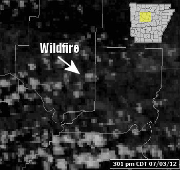 |
One of the largest fires during this time frame was in the Ouachita National Forest, and covered 685 acres. On July 3rd, over 500 acres burned around Atkins (Pope County), and more than 140 homes were evacuated. More recently (July 25th), an 1,100 acre blaze forced more than 1,000 people to leave areas around Ola and Birta (both in Yell County). Shelters were set up for people displaced by the fire. |
| In the picture: This wildfire north of Atkins (Pope County) started during the afternoon of 07/03/2012. |
|
|


 Follow us on YouTube