 |
| Abnormally Dry Conditions |
| At times, below normal precipitation will lead to a lack of ground water and worsening drought conditions in Arkansas. Check out the latest conditions below. |
|
|
 |
Monitoring Drought in Arkansas |
 |
| |
| Drought Status |
| |
|
|
|
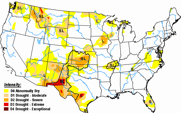
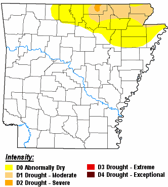
Moderate drought (D1) conditions existed in far northern Arkansas to begin April. Next Page Update: May 1, 2024
|
| |
| Drought Conditions (Percent Area) |
| Category |
Coverage |
| None |
79.17% |
| D0-D4 |
20.83% |
| D1-D4 |
5.80% |
| D2-D4 |
0% |
| D3-D4 |
0% |
| D4 |
0% |
|
| In the picture: There were moderate drought (D1) conditions in far northern Arkansas on 04/09/2024. |
| |
|
|
| |
 |
| In the picture: Drought conditions as of 04/09/2024. |
|
| |
|
Across the country, the worst drought conditions (at least D3) were in the southern Rockies and southern Plains, and portions of the upper Midwest.
Here at home in April (through the 15th), one to two inch rainfall deficits were common across northern Arkansas. Meanwhile, there was a one to more than four inch surplus of liquid in the southern half of the state.
|
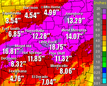
| Precipitation in April, 2024 (Through the 15th) |
| Site |
Amount |
Normal |
+/- |
% of Normal |
| Fayetteville (NW AR) |
1.35 |
2.15 |
-0.80 |
63% |
| Harrison (NC AR) |
1.53 |
2.16 |
-0.63 |
71% |
| Jonesboro (NE AR) |
0.47 |
2.28 |
-1.81 |
21% |
| Fort Smith (WC AR) |
1.89 |
2.20 |
-0.31 |
86% |
| Little Rock (C AR) |
1.85 |
2.58 |
-0.73 |
72% |
| West Memphis (EC AR) |
3.18 |
2.28 |
+0.90 |
139% |
| Texarkana (SW AR) |
4.17 |
2.00 |
+2.17 |
208% |
| El Dorado (SC AR) |
4.16 |
2.70 |
+1.46 |
154% |
| Pine Bluff (SE AR) |
3.76 |
2.60 |
+1.16 |
145% |
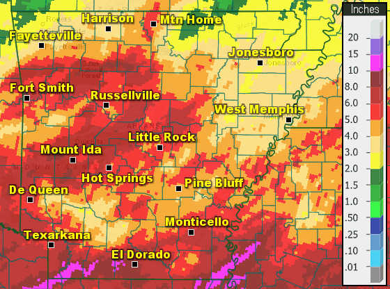 |
| In the picture: Precipitation across Arkansas in March, 2024. |
|
| |
|
In March, wet to very wet conditions (by more than two inches in some cases) were noted across much of central and southern Arkansas. It was drier than usual (mostly by one to two inches) in the north and east.
|
| Precipitation in March, 2024 |
| Site |
Amount |
Normal |
+/- |
% of Normal |
| Fayetteville (NW AR) |
3.73 |
3.98 |
-0.25 |
94% |
| Harrison (NC AR) |
3.29 |
3.91 |
-0.62 |
84% |
| Jonesboro (NE AR) |
3.00 |
4.73 |
-1.73 |
63% |
| Fort Smith (WC AR) |
6.04 |
3.90 |
+2.14 |
155% |
| Little Rock (C AR) |
5.98 |
4.96 |
+1.02 |
121% |
| West Memphis (EC AR) |
2.93 |
5.10 |
-2.17 |
57% |
| Texarkana (SW AR) |
5.53 |
4.45 |
+1.08 |
124% |
| El Dorado (SC AR) |
9.44 |
5.10 |
+4.34 |
185% |
| Pine Bluff (SE AR) |
4.38 |
5.29 |
-0.91 |
83% |
|
In 2024 (through April 15th), rainfall was above to much above average in the central and southern counties, and a little below average in the north/east.
|
| Precipitation in 2024 (Through April 15th) |
| Site |
Amount |
Normal |
+/- |
% of Normal |
| Fayetteville (NW AR) |
9.22 |
11.44 |
-2.22 |
81% |
| Harrison (NC AR) |
11.35 |
11.16 |
+0.19 |
102% |
| Jonesboro (NE AR) |
14.09 |
14.32 |
-0.23 |
98% |
| Fort Smith (WC AR) |
13.27 |
11.70 |
+1.57 |
113% |
| Little Rock (C AR) |
20.06 |
15.01 |
+5.05 |
134% |
| West Memphis (EC AR) |
14.34 |
15.51 |
-1.17 |
92% |
| Texarkana (SW AR) |
20.04 |
14.37 |
+5.67 |
139% |
| El Dorado (SC AR) |
25.86 |
16.66 |
+9.20 |
155% |
| Pine Bluff (SE AR) |
18.81 |
15.98 |
+2.83 |
118% |
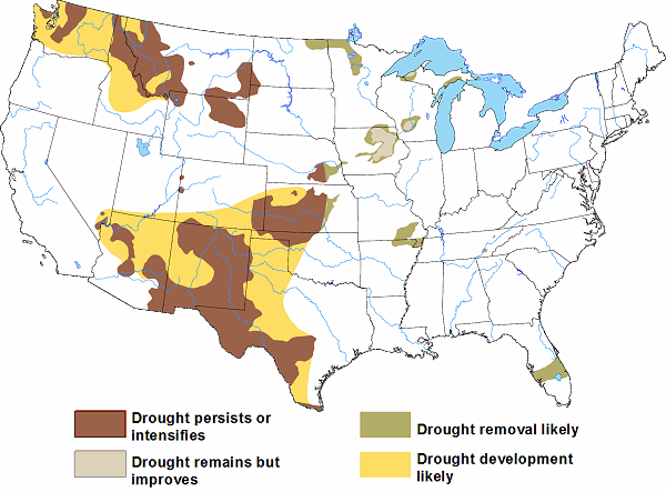 |
| In the picture: Drought outlook through June, 2024. |
|
| |
|
Looking ahead, El Niño (warmer than normal water temperatures near the equator in the Pacific Ocean) will stick around through the first half of 2024 before transitioning to La Niña (cooler than normal water) later in the year. Long range models continue to show more wetness than dryness in the coming weeks (heading deeper into spring), and drought is not expected to become much of an issue in the foreseeable future. We will monitor the situation closely.
|
| Precipitation Statistics (2019-2023) |
| Site |
2023 |
+/- |
2022 |
+/- |
2021 |
+/- |
2020 |
+/- |
2019 |
+/- |
Total +/- |
| Fayetteville (NW AR) |
44.89 |
-2.07 |
41.76 |
-5.20 |
42.60 |
-4.36 |
49.86 |
+1.35 |
65.26 |
+16.75 |
+6.47 |
| Harrison (NC AR) |
44.59 |
+0.09 |
43.23 |
-1.27 |
46.81 |
+2.31 |
53.60 |
+9.46 |
56.98 |
+12.84 |
+23.43 |
| Jonesboro (NE AR) |
48.43 |
-0.08 |
47.27 |
-1.24 |
41.36 |
-7.15 |
56.25 |
+8.15 |
65.89 |
+17.79 |
+17.47 |
| Fort Smith (WC AR) |
45.29 |
-2.05 |
56.01 |
+8.67 |
50.60 |
+3.26 |
61.62 |
+16.16 |
67.50 |
+22.04 |
+48.08 |
| Little Rock (C AR) |
56.86 |
+6.44 |
48.29 |
-2.13 |
43.71 |
-6.71 |
60.04 |
+10.29 |
60.46 |
+10.71 |
+18.60 |
| West Memphis (EC AR) |
46.99 |
-3.41 |
53.17 |
+2.77 |
44.66 |
-5.74 |
53.89 |
+1.66 |
73.86 |
+20.63 |
+15.91 |
| Texarkana (SW AR) |
56.66 |
+7.79 |
45.38 |
-3.49 |
47.03 |
-1.84 |
68.81 |
+19.16 |
51.53 |
+1.88 |
+23.50 |
| El Dorado (SC AR) |
57.11 |
+4.99 |
50.41 |
-1.71 |
49.27 |
-2.85 |
66.18 |
+13.26 |
60.64 |
+7.72 |
+21.41 |
| Pine Bluff (SE AR) |
48.39 |
-2.42 |
46.87 |
-3.94 |
44.94 |
-5.87 |
63.04 |
+11.89 |
63.96 |
+12.81 |
+12.47 |
|
Looking back at recorded history, drought is no stranger to Arkansas. The good news is that periods of drought are generally short-lived. That was the case in 2011 when a deluge unfolded from mid-November to mid-December.
|
 |
Twelve to more than eighteen inches of rain was measured from Mena (Polk County) to Mount Ida (Montgomery County), Russellville (Pope County), Little Rock (Pulaski County), Jonesboro (Craighead County) and West Memphis (Crittenden County). |
| In the picture: Thirty day rainfall through 600 am CST on 12/11/2011. |
|
Hurricane Isaac brought much needed rain to drought stricken areas of the south and east in late August, 2012. Pine Bluff (Jefferson County) had 8.39 inches in the forty eight hour period ending at 700 am CDT on September 1st.
|
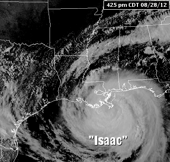 |
| In the picture: Hurricane Isaac was just off the coast of Louisiana at 425 pm CDT on 08/28/2012. |
|
In September, 2013, areas from Little Rock (Pulaski County) southward got two to four inches of rain, with locally over six inches on the 19th/20th. Some of these amounts exceeded what would normally be expected during the entire month. This busted a short term extreme (D3) drought that peaked just a few days prior to the rain.
The southern half of Arkansas dealt with a moderate to extreme drought (D2 to D4) in October, 2015. Very dry air and heat in the middle of the month made conditions worse. On the 15th, Little Rock experienced the hottest October day on record when the thermometer showed 98 degrees. Fast forward to the wettest November in recorded state history, and the drought was erased.
|
| Streamflow and Soil Moisture |
|
|


 Follow us on YouTube