
Gusty winds are expected from portions of the Mid-Atlantic into the Northeast through the night following the system that brought rain to the area. An atmospheric river will move into the Northwest late today into Saturday bringing moderate to heavy rainfall, mountain snow, windy conditions, and high surf to the area over the weekend. Read More >
NOTE: Financial damage estimates are the value when the event occurred.
1878 (Black Hills) Flooding caused minor damage in April, May and June. On July 12, a freight train of ten or twelve ox wagons loaded with machinery for the Homestake Mine were covered with water and some washed downstream. Rapid Creek rose ten feet very quickly. One death was reported.
May 1883 (Black Hills) Heavy, wet spring snowstorms caused flooding which washed away most of Deadwood on May 16. Several days of torrential rain over the Black Hills caused flooding on Rapid Creek and the Belle Fourche River on May 17 - 18. Four deaths and $250,000 damage was reported.
1885 (Black Hills) More than $25,000 damage occurred when Rapid, Box Elder, and Elk creeks flooded.
June 17, 1890 (Deadwood) Heavy rain caused flooding in Deadwood.
August 15, 1890 (Rapid City) Heavy rain caused flash flooding on Rapid Creek in Rapid City. All the bridges across Rapid Creek in Rapid City were destroyed; water was two feet deep on Main Street and cellars were filled with water causing considerable damage. Water covered the flat between 5th and West Boulevard and from Omaha Street to Denver Street.
June 6, 1892 (Rapid City) Flooding caused damage to railroads and roads.
July 2, 1901 (Rapid City) Street flooding occurred in Rapid City.
July 1905 (Bad River) The Bad River flooded from Philip to Fort Pierre due to a week of heavy rain. Seventeen houses in Fort Pierre were swept into the Missouri River, 40 houses were damaged and 75 families evacuated. A series of small dams washed out, and the river level was an estimated 12 feet above flood stage. This was three feet higher than the highest documented flood of June 1867. $100,000 damage and seven deaths were reported.
June 12, 1907 (Rapid Creek) An average of five inches of rain caused rapid melting of snow and the worse flood in Rapid City prior to 1972. Every bridge over Rapid Creek between Mystic and Creston was destroyed. Canyon Lake washed out and remained dry until 1932. Peak flow was estimated at 13,000 cfs with $100,000 damage in Rapid City, plus $100,000 damage to railroads and four deaths.
May and June 1909 (Northern Black Hills) Thunderstorms flooded streets, railroads and mines in Deadwood, Lead, Rapid City, and Spearfish. Spearfish Creek was a half mile wide at the mouth with flooding on Elk and Box Elder creeks. Twenty houses along Bear Butte Creek were evacuated on June 11. In Belle Fourche, $500,000 damage was reported.
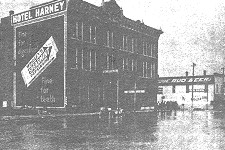
Flooding in Rapid City, June 11, 1909 (photo courtesy of the Rapid City Journal).
August 1915 (Bad River) Flooding occurred several times in 1915. Heavy snowfall in March was followed by heavy rain in May. Flooding in August destroyed railroad tracks, a few homes and damaged a stockyard. The Bad River was nearly a mile wide in some locations.
May 1920 (Black Hills and the Plains) on May 10-2, 4.75 inches of rain fell on saturated ground. The Weather Bureau issued warnings for a rise to six feet above normal on Rapid Creek which was already 3.5 feet above normal. Bridges over Rapid Creek were destroyed. Flooding was reported over a large part of the Cheyenne basin with an estimated 13 foot crest at Edgemont, 18 feet at Wasta and 19 feet at Eagle Butte. Six deaths, $100,000 in railroad damage and $200,000 total damage were reported.
April 1924 (Belle Fourche) Warm temperatures and rain caused rapid melting of five feet of snow, causing flooding in Belle Fourche beginning on April 9. Fifty-five houses were destroyed and damage estimates were $150,000.
May 27, 1926 (Rapid City, Sturgis, and Deadwood) Three inches of rain fell in three hours causing flooding.
May 1927 (Western South Dakota) Flooding occurred over the Cheyenne, Bad, White and Missouri rivers. A wet, snowy spring followed three years of drought. In Rapid City, 51.9 inches of snow fell March 31 to April 15. Heavy rain over the Cheyenne, Bad and White River basins began May 5 with the worst flooding on the Cheyenne and Bad River. The stage on the Bad River at Fort Pierre was estimated at 31 feet. The Bad River flood washed out train tracks and trestles, and the train did not run for a month.
June 17, 1937 (Hot Springs) Estimated $200,000 damage.
September 4, 1938 (Hot Springs) Discharge of 13,100 cfs was recorded at the Hot Spring river gauge.
1947 (Hot Springs) Flooding along Fall River (prior to Cold Brook Reservoir).

Hot Springs, prior to construction of Coldbrook Reservoir (photo courtesy of the Rapid City Journal).
August 15, 1949 (Rapid City) Thunderstorms produced flash flooding and large hail in Rapid City causing $198,000 in damage. Peak flow on Rapid Creek was 563 cfs.
May 22, 1952 (Rapid City) Flow on Rapid Creek was 2,500 cfs and damage occurred to the Canyon Lake area. Landslides in Deadwood and Sturgis caused damage to streets and gas lines, and washed out bridges. In 24 hours, 5.55 inches was reported at Pactola with a storm total 6.26 inches.
July 28, 1955 (Pennington County) Minor flooding occurred in Mystic, Rochford and Pactola after five inches of rain fell.
June 24, 1959 (Crook County) A thunderstorm moved down Miller Creek producing flash flooding south of Sundance.
June 20, 1960 (Rapid City/New Underwood) Basement and street flooding occurred due to heavy rain from thunderstorms.
August 1, 1960 (Newcastle) Heavy rain flooded Highway 16 near the refinery.
June 1, 1961 (Newcastle) Runoff from heavy rain flooded Highway 16 near the refinery.
June 1962 (Rapid City) Rapid Creek left its banks on June 15. Nine days later, over three inches of rain fell over the Black Hills. Two motels, 120 mobile homes, and over 400 houses were damaged in Rapid City. Bridges, roads, sewer systems, and recreation areas along Rapid Creek were damaged. Extensive road and bridge damage in Sturgis, Deadwood, and Whitewood. Damage to road equipment estimated at $200,000. On June 30, 1.5 inches of rain fell in Rapid City damaging north Rapid City and the South Canyon area for the second time.
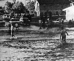
Street flooding in Rapid City, June 1962 (photo courtesy of the Rapid City Journal).
July 1962 (Black Hills) On the evening of July 13, 1962, two to five inches of rain fell in three hours in Cleghorn Canyon, South Canyon, Dark Canyon and Canyon Lake areas just west of Rapid City. Rapid Creek flooded and washed out six bridges. A mobile home company lost 22 new mobile homes and 1200 to 1500 people were forced to temporarily leave their homes. Damage was estimated at $1.9 million for the summer.
May 15, 1965 (Northern Black Hills) Flash floods, from heavy rain falling on 30 inches of snow, damaged portions of Deadwood, Spearfish and Sturgis. A record crest was reported on Rapid Creek near Silver City. Many houses in the Spearfish-Sturgis area were damaged or destroyed. Two million dollars in damage was reported.
July 22, 1966 (Gillette) Heavy rain caused flash flooding in south and east Gillette.
June 15, 1967 (Bad River) This flood produced the highest stage since 1929 on the Bad River. Thunderstorms moved through the area on several preceding days, saturating the soils and increasing flows along the river. Philip reported 3.13 inches and Pine Ridge 3.80 inches of rain. The gage on the Missouri River at Fort Pierre reported a stage of 29.55 feet (43,000 cfs). Thirty mobile homes had to be moved to higher ground.
June 9-10, 1972 (Eastern Black Hills) Record flows were reported on Rapid, Battle, Bear Butte, and Boxelder creeks. On June 9 a stationary front, with moderate southeast surface flow, moved through high pressure aloft. A strong flow of warm, moist air near the surface fed the storms and anchored them against the Hills for six to eight hours. An average of six inches of rain fell with up to 15 inches reported. Rainfall intensities of two to six inches/hour were common. Canyon Lake breached, adding to the wall of water that poured through Rapid City. Flow on Rapid Creek in Rapid City was estimated at 50,000 cfs. After the flood, 750 acres near Rapid Creek were designated as a floodway. 238 deaths and $164 million in damages were reported.

Flood damage on East Blvd. at Omaha St. in Rapid City, June 10, 1972 (photo courtesy of the Rapid City Journal).
July 21, 1973 (Northeastern Wyoming) Torrential rains accompanied by hail caused flash flooding in southern Weston County. Several earthen dams breached, causing damage to bridges and roads. Crop and property damage was substantial. In Gillette, heavy rain amounting to 1.5 inches in one hour resulted in flooded streets and basements and damage to new construction.
August 21, 1973 (Beulah) Heavy rain caused flash flooding on Sand Creek washing out roads and damaging houses. A pickup truck and a trailer were washed into a bridge abutment.
June 8, 1975 (Rapid City) 2.5 inches of rain in 30 minutes which damaged houses, cars and parks.
June 25, 1975 (Upton) Street flooding in Upton from heavy rain.
June 13-14, 1976 (Northern Black Hills) A strong low pressure system moved toward central South Dakota, and the cold core low aloft stalled out over western South Dakota. Moist unstable air wrapped around the low and pushed up the northern slopes of the Hills on June 13. By 3:00 p.m. on June 14, 4.08 inches had fallen at Sturgis, with nine inches by midnight. Storm totals included ten inches at Galena and eight inches at Whitewood. Most property damage occurred in Spearfish along Spearfish Creek, Deadwood along Whitewood Creek and Sturgis along Bear Butte and Vanocker creeks. Major damage occurred along Redwater Creek near the Wyoming state line and in Keystone near Grizzly and Battle creeks. Damage estimates were three million dollars in Sturgis with two million dollars elsewhere. One death was reported.
March 1978 (Western South Dakota) Temperatures in January and February were 10-12 degrees below average, but were followed by a warm up in March. Ice melted then broke up and piled against bridges and other constrictions. The White River near Oacoma crested at 23.59 feet on March 14th flooding a total of 3,000 acres and four ranches. Two mobile homes near the Bad River were moved and six houses were evacuated.
May 1978 (Northeastern Wyoming) A strong low pressure system developed over Colorado at the southern end of the cold front and the features became stationary. Southerly mid-level flow forced the precipitation northward over the stationary boundary and focused the precipitation over northeastern Wyoming for about 60 hours. Precipitation ended early on May 19 as the low and cold front moved over the central Dakotas. Total rainfall was three to six inches over northeast Wyoming including: Echeta 2NW reported 4.65 inches, Gillette 5.06 inches, and Dillinger 3.67 inches. Flooding was reported on May 22 along the Belle Fourche, Cheyenne (Wyoming portion) and Powder rivers and their tributaries due to the heavy rain. Keyhole Reservoir spilled for the first time in its 26-year history. Extensive damage to roads, bridges and buildings occurred. Campbell, Crook and Weston counties declared major disaster areas.
July 23, 1981 (Rapid City) In fifteen minutes, 0.71 inches of rain fell causing widespread street flooding. A youth was swept into a culvert and suffered minor injuries.
March 1982 (Cheyenne River) The second highest stage of record at Wasta which was 16.25 ft.
June 13, 1982 (Crook County) A thunderstorm dumped up to 7 inches of rain throughout the southeastern part of Crook County along with hail drifts from two to five feet in some places. Damage resulting from flooding was reported in the Moskee and Oshoto areas.
July 24, 1982 (Moorcroft) A thunderstorm dumped 2.3 inches of rain in a short period of time causing localized flooding.
July 25, 1982 (Gillette) An inch of rain fell in less than 20 minutes on already saturated ground causing flooding. Damage estimates from the flooding approached one million dollars.
March 1987 (Lower Bad, Cheyenne, Moreau and Grand Rivers) Rapid warming in the first week of March melted 20 to 30 inches of snow and brought many streams to near bank full. Numerous ice jams formed on the Grand and Moreau rivers in early March. Heavy snow cover from the Bad Basin to the lower Grand basin slowly melted until late March when storms produced two to three inches of rain over this area. On the evening of March 20, the lower Bad, Cheyenne, Moreau and Grand Rivers rose rapidly. The Bad River crested at 24.38 feet, 3 feet above flood stage, on March 21. No damage was reported.
May 16, 1987 (Wright) A severe thunderstorm dropped over 2.5 inches of rain over the town of Wright in 45 minutes. About 14 homes sustained minor damage and 3 homes had major damage. The 3 homes with major damage had approximately 3 to 14 inches of water in their basements.
July 30, 1987 (Campbell County) A line of strong thunderstorm produced heavy rain across Campbell County. Savageton received 1.5 inches of rain in 35 minutes. In Gillette, 1.5 inches of rain fell in less than an hour along with 1.5 inch diameter hail. Many streets and a few apartments were flooded due to the torrential rain in Savageton and Gillette.
August 11, 1987 (Crook County) Thunderstorms with heavy rain swept through northern Crook County during the afternoon. Highway 24 south of Hulett was closed due to flooding and fences were washed out north of Aladdin.
May 10-12, 1991 (Southwestern South Dakota) A strong upper level low over the western United States with southerly flow over South Dakota brought copious amounts of moisture into the southern Black Hills. A surface stationary front remained over western South Dakota through the period. Very heavy rainfall over the southern Black Hills and southwestern South Dakota caused extensive flooding. Total rainfall was four to ten inches. In Oral, flood waters carried houses a few hundred feet off foundations, while many highways, roads, culverts and bridges were completely washed out by the heavy rains. Towns along the Cheyenne and White Rivers were evacuated. One million dollars in damage was reported.
June 13, 1991 (Sundance) A thunderstorm produced 2.72 inches of rain in 45 minutes flooding streets and basements.
August 19, 1993 (Rozet) A person working on an oil rig died when he was caught in a flash flood in what usually is a dry creek bed north of Rozet.
May and June 1993 (Battle Creek) Two inches of rain fell in twenty minutes on May 5. Five thousand dollars in road and culvert damage occurred near Hill City. On June 7 three inches of rain in ten hours caused localized flooding. Numerous roads were closed due to water, mudslides or debris and a campground near Keystone was evacuated.
August 6, 1993 (Rapid City) Brief, heavy rain caused three to four feet of water over a road.
May 1995 (Western South Dakota) A strong upper-level low over the central and southern Rockies on the evening of May 7 slowly pushed northeast across the central Plains, producing heavy rain in western South Dakota. Early on May 8 the surface low over the central Plains pulled moist air into western South Dakota. Strong upslope flow developed as surface winds backed to the north. With northeast flow aloft, the heaviest precipitation fell north-northeast of the Black Hills. Rainfall amounts ranged from over two inches in southeastern Rapid City to 8.6 inches in Deadwood. The Belle Fourche, Bad and Cheyenne Rivers approached or reached flood stage with over 100 roads closed in Lawrence, southwest Meade and southern Butte counties. Damage was estimated at $20 million.
May 30, 1996 (Pennington and Custer Counties) Three to six inches of rain fell on saturated ground. Two to three feet of water was reported on the Highway 79 Bridge at Spring Creek near Hermosa. French Creek left its banks and the Hart Ranch Campground and homes near Rapid Creek were evacuated.
June 14, 1996 (Meade County) Nearly stationary thunderstorms dumped up to 14 inches of rain, washing out the road from Sturgis to Hereford. Numerous damage to cars, houses, ranches and livestock caused an estimated loss of $260,000.
May 24, 1997 (Rapid Creek) Stationary thunderstorms produced four to five inches of rain, causing minor flooding.
June 2, 1997 (Pennington County) Two to three inches of rain fell in less than an hour from Deerfield to Rapid City. Up to 4.5 inches of rain fell in thirty minutes in Chapel Valley. Six to eight feet of water in Cleghorn Canyon washed out driveways and bridges. Eight to ten feet of water in Red Rock Canyon washed out driveways and bridges. Minor flooding reported at a golf course near Chapel Valley. In Rapid City, six to twelve inches of water was reported over roads with the highest flows on Rapid Creek since 1972.

Bridge damage in Cleghorn Canyon, June 1997.
July 24, 1997 (Lawrence and Pennington Counties) Stationary thunderstorms produced over five inches of rain in the Lead and Deadwood area. Rock and mud slides partially blocked Highway 14A west of Lead. Flooding occurred near the intersection of Highway 85 and Highway 385. Several secondary roads were washed out around Lead. Whitewood Creek and Yellow Creek were over their banks. In Pennington County, four to five inches of rain caused the south fork of Rapid Creek to rise over its banks five miles west of Rochford. Minor flooding also occurred along the north fork and along the tributaries of Rapid Creek.
June 22, 1998 (Weston) General flooding was reported near Weston with stock ponds overflowing and roads being threatened.
July 1 1998 (Campbell County) Heavy rains of six inches in an hour caused a stock dam to breach on the Iberland Ranch. Highway 387 about 26 miles southwest of Wright was flooded.
July 2, 1998 (Campbell & Weston Counties) Flood waters covered highway 50 between mile markers 16 and 20 about 18 miles southwest of Gillette. Oil Creek Road near Four Corners was washed out in several places.
June 18, 1999 (Keystone) In less than 90 minutes, three to four inches of rain fell around the Keystone area. Sections of Old Hill City Rd washed away. The 1880 Historic Train had several hundred feet of railroad track wash away at a cost of $300,000. The flood stage at Camp Judson on Battle Creek is 6.5 feet and the river reached 8.48 feet around 1648 MST and dropped back below flood stage at 1830 MST.
June 29, 1999 (Hermosa) Water along French and Grace Coolidge Creeks rose rapidly after three to four inches of rain in less than an hour. Some vehicles in the Hermosa area had water up to the doors because local drainage systems could not keep up.
August 7, 1999 (Custer County) Nearly stationary thunderstorms produced three to seven inches of rainfall in the French Creek basin. This water inundated French Creek which flows through Custer and considerable damage occurred to county roads and portions of the city of Custer. Over one dozen evacuations were ordered. One major result of the flooding was the contamination of the waste treatment plant which took in 2.9 million gallons of water in 48 hours, and it can normally handle just 500,000 gallons of water a day. Damage to streets, bridges, highways and public buildings was approximately $115,000 with no estimate for private property. Numerous homes had three to four inches of water in their basements.
May 28, 2001 (Gillette) A surface trough across central Wyoming with weak southeasterly flow caused training storms in the Donkey Creek basin. Dew points were in the mid 40’s with temperatures in the 70’s as the mid-level ridge was anchored over the plains. Model sounding for Gillette indicated low CAPE, near average precipitable water and weak upper level winds. These storms produced water in basements and submerged county roads under four feet of water. Damage included $50,000 at a golf course and business losses totaled $400,000. Storm total precipitation ranged from 0.18 inches at the Gillette Airport to 7.5 inches 4SW Gillette.
June 13, 2001 (Northern Crook County) Locally heavy rain from thunderstorms overnight produced a flash flood on the Little Missouri River at Government Canyon. A road was washed out and 8 feet of water was covering the roadway.
July 15, 2001 (Rapid City) Very heavy rain overwhelmed street drainages in downtown Rapid City. Vehicles were reported to have moved “several feet” in flooded downtown streets. Water covered Nemo Road in northwestern Rapid City where the river gage at Echo Canyon went over flood stage.
July 21, 2001 (Keystone) One to three inches of rain put Highway 16A under water. Damage at several businesses and houses was estimated at $50,000.
August 12, 2001 (West of Custer) Flash flooding occurred through Buck Springs and Gillette Canyons. Normally dry creek beds had water flowing from 18 inches to 4 feet deep and from 6 feet to 20 feet wide. Excessive runoff from scorched earth of the Jasper Fire of 2000 contributed more to the flooding than the heavy rainfall.
June 2, 2002 (Rozet) In one hour,1.25 inches of rain fell which clogged storm drains causing water to flow over Bishop Road near Rozet.
July 5, 2002 (Pringle) Heavy rain left three to four inches of standing water in the town of Pringle, and water covered roads adjacent to Bear Creek around Pringle. An inch of rain was recorded in ten minutes in Pringle and radar estimates were around 2.5 inches per hour over the area. A total of three inches of rain was reported which produced standing water on County Road 341.
August 8, 2002 (Deadwood) The Grizzly Gulch automatic rain gage received 0.39 inches in 15 minutes. Other stations around Deadwood reported around 0.75 inches in the same period of time. The heavy rainfall caused a mudslide near the Grizzly Gulch burn area. One house was destroyed and 20 others were damaged. The hospital retaining wall was destroyed and hospital offices were damaged. Several vehicles were also damaged.
August 24, 2002 (Deadwood) A severe thunderstorm moved over Deadwood, producing locally heavy rain. This rainfall was in addition to rains received the past few days. Steep terrain, which was severely burned in a recent forest fire and had flash flooding and mudslides a few weeks earlier, experienced very rapid runoff again. Flash Flooding and mudslides sent up to three feet of water, mud, and debris through downtown Deadwood. No injuries were reported and only cosmetic damage was reported by businesses.
June 13, 2003 (Fall River County) Three to four inches of rain with training thunderstorms caused Black Banks Creek to flow out of its banks.
June 17, 2003 (Shannon County) Up to five inches of rain over White Clay Creek basin briefly closed Highway 18.
July 5, 2003 (Pennington County) Thunderstorms produced rapid runoff east of Keystone in the Battle Creek Fire burn area. Seventy-five people were stranded at Rushmore Cave as water and debris up to three feet deep flowed over the road.
August 17, 2003 (Pennington County) Radar estimated 2.5 to 4.5 inches of rain near the Battle Creek burn area, and two to three feet of water was reported over roads in Hell Canyon.
June 8, 2004 (South Central South Dakota) Eight inches of rain fell in Witten (Tripp County) flooding basements and washing out roads in Todd County.
June 20, 2004 (Keystone) Along Battle Creek, 1.5 to 2.0 inches of rain fell in an hour. The river gage at Camp Judson (JUDS2) was within a foot of flood stage. No damage reported.
July 1, 2004 (Central Lawrence County) Flash flooding occurred in Lead as 2 to 3 inches of rain fell in about an hour. Road flooding was reported in Lead with debris flowing down the streets and into storm sewers, causing damage. Some basements were flooded in low lying areas of town.
July 3, 2004 (Rapid City) One to two inches of rain fell in Rapid City in less than an hour which caused minor street flooding. Rapid Creek went out of its banks near Creek Drive in Rapid City and Meade Street flooded. No injuries or damage were reported.
July 13, 2004 (Campbell County) Severe thunderstorms developed and moved across southern parts of Campbell County. Heavy rain flooded roads in southern Campbell County including Highway 50. Hail to the size of golf balls were reported around Wright. A weak tornado briefly touched down just west of Highway 59 at Reno Junction with no injuries or damage reported.
May 6, 2005 (Southwestern SD) Up to five inches of rain fell in a 90 minute period over Beaver Creek just west of Buffalo Gap. The creek flooded Custer County Road 101 in several places and eroded the road near a large culvert making it impassable to traffic. Water height was estimated at 8 feet from evidence on large cottonwood trees. The water continued downstream flooding other county roads.
May 10-14, 2005 (White River) Rain changed over to freezing rain and snow. High flows were noted on the Bad and White Rivers. The White River was out of its bank at Highway 83 south of Murdo on May 14. Minor flooding of agricultural land occurred along the White River from south of Belvidere to Oacoma.
June 12-13, 2005 (Southwestern SD) Along Hat Creek, 3.5 inches of rain caused flooding from Route 71 to the Cheyenne River. The 75-100 feet wide channel was swift and carried debris. Horsehead Creek was out of its banks and over County Highways 4 and 20, four miles southwest of Oelrichs. Water was reported running over County Highway 5A, southwest of Edgemont, and County Road 8S was washed out when Cottonwood Creek left its banks. No reports were received of injuries or fatalities.
June 24, 2005 (Rozet) Heavy rains north of Rozet resulted in the flooding of Cow Creek Road about ten miles north of Rozet for a short period of time.
July 5, 2005 (Southern Black Hills) Water from heavy rain accumulated two inches deep in the Rushmore Cave gift shop. A supercell thunderstorm moved slowly southeast across central Pennington county, central Custer County, and eastern Fall River County producing large hail and locally heavy rain.
July 23-24, 2005 (Hot Springs) One to two inches of rain fell in about an hour and flooded roads in the Hot Springs area. Many streets in downtown Hot Springs were covered with a foot of water. The Fall River overflowed the low water crossings at Sixth Street and at Joplin.
August 12, 2005 (Hot Springs) Heavy rain in a short period of time around Hot Springs caused flash flooding in Hot Springs. Many roads in downtown Hot Springs were covered with up to a foot of water and the Fall River at Hot Springs rose near bankfull for a brief time with debris in the stream bed clogging the river.
April 22-25, 2007 (Camp Crook) On April 17, severe thunderstorms produced large hail and up to two inches of rain southwest of Camp Crook. On April 17 -19, heavy snowfall resulted in two to three inches of liquid water equivalent in northeast Wyoming and extreme southeast Montana in the upper reaches of the Little Missouri River Basin. Two days after the heavy snowfall, temperatures quickly warmed into the 70s, rapidly melting the snow. On April 21, the Little Missouri River at Camp Crook, CACS2, rose quickly. Within 12 hours, the river rose eight feet. The river crested at 14.8 ft at Camp Crook on the April 22, and fell below flood stage on April 25.
May 5, 2007 (Interior) Interior, SD received 3.95 inches of rain in less than three hours causing the White River to rise five feet. Highway 44 south of Interior was covered with water due to a plugged culvert, and a county road was washed out. Damage was estimated at $67,750.
May 5, 2007 (Campbell and Crook Counties) Two to four inches of rain fell over Campbell and Crook counties in northeastern Wyoming. Minor street flooding occurred in Gillette, and water flowed over several county roads north and east of Gillette washing out culverts. The Little Powder and Big Powder rivers both overflowed their banks. Damage was estimated at $58,025.
June 1-2, 2007 (Sturgis and Spearfish) Several roads in Spearfish and Sturgis were closed due to flooding along Spearfish Creek, Whitewood Creek and Bear Butte Creek.
June 2, 2007 (Butte County) The Redwater River, Belle Fourche River and Hay Creek around Belle Fourche produced minor flooding. Wood Road near the Butte/Lawrence county line was closed due to water flowing over the bridge.
June 8, 2007 (Campbell County) Donkey Creek flooded the Moran Ranch Road one mile east of Gillette.
June 12, 2007 (Todd County) Flooding along Cut Meat Creek closed Highway 18 and secondary roads south and west of Parmelee near He Dog Lake. One basement was flooded in Norris.
August 17, 2007 (Hermosa) Intense thunderstorms produced up to 10.5 inches of rain west of Hermosa. An automated rain gage in Hermosa reported 0.86 inches in 15 minutes between 7:30 pm and 7:45 pm. Three rain gages reported 10 inches or more. A rain gage in Ghost Canyon reported 5.33 inches and a gage in Hermosa reported 5.5 inches of rainfall. Over 50 homes were flooded, Highway 40 and Highway 36 were damaged by flood waters and numerous roads and vehicles sustained damage.

Damaged railroad track in Hermosa August 2007.
August 17, 2007 (Piedmont) Thunderstorms brought large hail and heavy rain to the Piedmont area. The heavy rain falling on the burn scars from the Ricco, Little Elk Creek and Eastridge fires caused flash flood debris flows along Chimney Canyon, Stagebarn Canyon, and Little Elk Creek roads. At least 20 homes were flooded, portions of the railroad tracks in Piedmont were washed out and several vehicles were damaged from the flash flooding. Due to the severe hail, almost all of Piedmonts 150 residents reported some type of property damage.
May 6-11, 2008 (Northwestern South Dakota) Heavy rain falling on snow remaining from the previous week’s blizzard caused flooding over northwestern South Dakota, the northern Black Hills, and northern foothills. Rainfall amounts on the plains were 0.75 to 1.0 inches with 1.0 to 2.5 inches of rain falling over the northern Black Hills. The water content of the snow was two to five inches. The Little Missouri River at Camp Crook crested at 14.11 feet (FS is 12 feet). Minor flooding occurred along the Grand, Moreau, Belle Fourche, Willow Creek, Frog Creek, Indian Creek, Sand Creek, Elk Creek, Bear Butte Creek, Spearfish Creek, False Bottom Creek, Whitewood Creek and their tributaries. Low water crossings and some side streets were flooding along Bear Butte Creek. Several secondary roads in Sturgis were closed. Streets on the east side of Spearfish were flooded; flooding was also reported at Brownsville and the Tomahawk Golf Course south of Deadwood.
May 23-24, 2008 (Northeast Wyoming) As much as four inches of rain in two days caused widespread flooding over northeastern Wyoming. The flooding washed out culverts and forced the closing of secondary roads. A few homes and basements were also flooded. Flooding was observed in Gillette, Wright, Rozet, Weston, Moorcroft, Newcastle, Clareton and Rochelle. Minor flooding was observed along Skull Creek, the Belle Fourche River, and the Little Powder River from Weston to the Montana State Line.
May 23-26, 2008 (Black Hills) Three to five inches of rain fell over the central Black Hills and eastern foothills. The water covered secondary roads and side streets, washed out several roads and culverts and flooded yards. Heavy rain caused flooding in Nisland, Vale, Belle Fourche, Spearfish, Whitewood, Tilford, Keystone, Rapid City, Rapid Valley, Hermosa, Custer and Custer State Park. Minor flooding was observed along the Belle Fourche River, Willow Creek and Dry Creek near Newell, Stinking Water Creek, Maloney Creek, Redwater River, False Bottom Creek, Whitewood Creek, Elk Creek from Tilford to the confluence of the Cheyenne River, Rapid Creek from the fairgrounds to east of Rapid Valley, Grace Coolidge Creek and Battle Creek. Elk Creek east of Piedmont crested at 11.5 ft; 2.5 ft over flood stage. Six yards and a basement along 220th St north of Box Elder were flooded as well as several basements and yards in the Golden Valley Subdivision east of Piedmont. Battle Creek at Hermosa crested at 10 ft which is two feet over flood stage.
May 23-26, 2008 (Southwest South Dakota) Heavy rain flooded several highways and secondary roads. Highway 44 south of Kadoka was flooded. Flooding was also observed along the White River, Bear-in-the-Lodge Creek, and their tributaries.
May 23-26, 2008 (Cheyenne River) Several days of heavy rain and rain runoff caused moderate flooding along the Cheyenne River from the confluence of the Belle Fourche River to Lake Oahe.
June 1-2, 2008 (Fall River and Custer Counties) Between 2.5 and 3 inches of rain fell over Sheps and Alabaugh Canyons southwest of Hot Springs. A section of Sheps Canyon Road was washed out, several culverts were damaged, and trees fell across roads near Angostura Reservoir. Significant flooding was reported near Cascade Springs. Over two inches of rain fell over central and eastern Custer County. Driveways and yards were flooded east of Hermosa along Highway 40 to the Cheyenne River.
June 4, 2008 (North Rapid City) One to two inches of rain and four inches of hail fell in less than 30 minutes, causing flash flooding on the north side of Rapid City and Country Road along the Pennington/Meade County line. Homes, highways and streets were damaged from this flash flood.
June 4-7, 2008 (Pennington and Meade Counties) Two to three inches of rain in 18 hours on saturated soils caused flooding in central and eastern Pennington County and southern Meade County on June 4. An additional one to two inches of rain on June 5 exacerbated the flooding. Houses, highways and streets were damaged by the high water and several stock dams failed. Flooding was reported in north Rapid City, Box Elder, New Underwood, Quinn, Wall, Creighton, along Elk Creek, Alkali Creek, Antelope Creek and the Belle Fourche River from east of Piedmont to Viewfield and Elm Springs.
June 5-8, 2008 (Western South Dakota) Flooding from 2.5 to 3.5 inches of rain on saturated soils damaged homes and destroyed culverts and roads. Levels along the Belle Fourche River were among the highest levels ever recorded. Flooding was observed along Redwater Creek, Redwater River, Willow Creek, Hay Creek, Indian Creek, Moreau River, Whitewood Creek, False Bottom Creek, Bear Butte Creek, Spearfish Creek and their tributaries. Several stock dams failed and the embankment next to the spillway at Newell Lake nearly eroded. Water covered Highway 85 south of Interstate 90.
June 5-12, 2008 (Northwestern and Central South Dakota) Runoff from three to seven inches of heavy rain caused flooding across northwestern and central South Dakota. Homes and roads were flooded and culverts were damaged. Record flooding was reported along the Moreau River northwest of Faith. Highway 20 west of Bison and Bixby, Cedar Canyon and Zeona Roads in southern Perkins County were covered by water. The Little Missouri River at Camp Crook crested two feet over flood stage. Minor flooding was reported around Camp Crook and Redig. Highway 79 was closed from Reva south to the Butte County line. A portion of Cherry Creek was inundated by flood waters. Major flooding was reported along Cherry Creek.
June 5-7, 2008 (Central and Southwestern South Dakota) Runoff from three to six inches of heavy rain flooded homes, basements, and yards. The flood waters inundated county roads and washed out culverts. The White River overflowed its banks from south of Interior to south of Belvidere and covered Highway 44. Flooding occurred in Philip and along Cottonwood Creek, the Bad River and their tributaries.
June 5-7, 2008 (South Central South Dakota) Runoff from three to five inches of heavy rain washed out culverts and county roads and flooded basements, driveways and yards. The White River in northern Tripp County crested four feet over flood stage. Minor flooding occurred around Parmelee.
June 5-9, 2008 (Cheyenne River) Record high flows along Elk Creek, Elm Springs and the Belle Fourche River combined with runoff from heavy rain to cause major flooding along the Cheyenne River from southeast of Elm Springs to Lake Oahe. The USGS river gauge on the Cheyenne River southeast of Plainview recorded a peak flow of 72,700 cfs around 2:00 am MDT June 7.
June 5-7, 2008 (Northeast Wyoming) Rainfall of 1.5 to 3.0 inches caused minor flooding along the Belle Fourche River, Oak Creek, Hay Creek and other small streams and flooded roads north of Aladdin.
July 6-7, 2008 (Rochford) Three to six inches of rain fell in two hours from O’Neil Pass to Roubaix Lake along north Rapid Creek upstream of Pactola Reservoir. Several culverts were washed out, several sections of roads were damaged and a home was flooded. The river gage on rapid Creek at Silver City above Pactola Reservoir reached the second highest flow of 1640 cfs.
Damage in Rochford, SD, July 2008.
July 18, 2008 (Hot Springs and Fall River County) Rainfall rates of one to two inches in a half hour flooded roads and yards from Hot Springs to Cascade Falls early in the morning. Later that day, runoff from heavy rain in eastern Wyoming caused minor flooding along the Cheyenne River upstream from Angostura reservoir.
July 22, 2008 (Fall River County) Runoff from heavy rain caused flash flooding along Fiddle Creek and Cottonwood Creek six miles southwest of Edgemont.
July 22, 2008 (Northern Campbell County Wyoming) Three to six inches of rain fell from near Weston to the Wyoming/Montana border. The flash flood washed out at least one secondary road causing one fatality and three injuries.
August 10, 2008 (Custer County) Runoff from heavy rain washed out a county road between Red Canyon and Pleasant Valley Creek in Custer County.
February 10-15, 2009 (White River) Several ice jams along the White River caused flooding from one mile west of Highway 83 to the Missouri River.
March 6-7, 2009 (Belle Fourche River) Minor flooding occurred due to ice jams along Indian Creek, South Fork of the Moreau River, and on the Belle Fourche River near the diversion canal. Water was flowing over Arpan Road from Indian Creek, several yards in Belle Fourche were flooded, and pasture land along the Moreau River flooded affecting ranchers and calving operations.
March 8-20, 2009 (Northwestern South Dakota) Ice jams and snowmelt caused minor flooding in northwestern South Dakota. Several roads and culverts were damaged. Minor flooding occurred along the Little Missouri River. The river gage at Camp Crook crested at 14.84 feet or 2.84 feet above flood stage. Minor flooding occurred along the Moreau River. The river gage northwest of Faith crested at 16.37 feet or 0.37 feet above flood stage.
April 10, 2009 (White River) Melting snow combined with a half inch to an inch of rain and caused minor flooding along the White River
April 14, 2009 (Hotchkiss Dam Breach) Hotchkiss Dam on Thybo Pond in eastern Harding County caused flash flooding along Rabbit Creek downstream to Sorum Dam.
April 12-22, 2009 (Western South Dakota Flooding) Heavy snow accumulations produced by several spring blizzards across western South Dakota began to melt in early April. Extensive areas of western South Dakota experienced flooding. Homes, basements, roads and culverts were damaged in Harding, Perkins, Butte, Meade, Ziebach, Haakon, and Pennington counties from the flooding. The Little Missouri River at Camp Crook flooded at least two homes and reported record flooding. Highway 212 northwest of Belle Fourche was covered with water six inches deep.
May 24, 2009 (Rapid City) Heavy rain of two to three inches caused flash flooding along Rapid Creek from the fairgrounds east to Rapid Valley.
June 13, 2009 (Hot Springs) Runoff from two inches of rain in an hour caused flash flooding in Hot Springs. Several roads and low water crossings were flooded.
June 14, 2009 (Southern Custer County) Runoff from heavy rain washed out Dewey Road between Red Canyon Creek and Pleasant Valley Creek.
June 14-15, 2009 (Pennington and Meade Counties) Two to four inches of rain in less than two hours combined with large hail to produce flash flooding in New Underwood and in south central Meade County. Most roads were impassable for a couple of hours during the evening on June 14. Flooding continued along Elk Creek from north of Box Elder to just south of Elm Springs.
Flash Flooding in southern Meade County. June 14, 2009.
July 2-3, 2009 (Southern Fall River County) Runoff from one to three inches of rain caused minor flooding along Indian Creek and Hat Creek in southern Fall River County. Water was reported over low water crossings and some culverts were blocked. Minor flooding of agricultural land and low lying fields were also observed.
March 4-14, 2010 (White River Flooding) Ice break-up and several ice jams caused flooding along the White River from south of Interior to the Missouri River. Flood waters south of Interior reached the shoulder of Highway 44. Between Murdo and White River along Highway 83, the river was reported to be a half mile wide. South of Reliance at OACS2, the gage height reached 23.4 feet (flood stage is 15 feet) which was one of the highest crests of record.
May 18, 2010 (Crook County) At least four inches of rain in less than three hours caused flash flooding along Oak Creek, Hay Creek and Beaver Creek in northeastern Crook County. Oak Creek Road and Mona Road were severely damaged. At one crossing, during the worst part of the flooding, the water was at least three feet above the road and was over 40 feet deep. There was a lot of debris and the water cut away at the road base at all of the culverts in the area.
May 24, 2010 (Pennington, Meade, Custer, and Fall River) A strong upper level wave combined with ample moisture to produce strong thunderstorms along the eastern and southern slopes of the Black Hills. Strong thunderstorms moved over the same areas for about three hours. Torrential rain of two to four inches fell in a brief period of time. This heavy rain caused flooding from Piedmont, SD southward to the Nebraska border.
June 16, 2010 (Dupree) During the evening, four to seven inches of rain fell around Dupree, SD. Flash flooding occurred in Dupree and along Bear Creek, Ash Creek, and along the Moreau River. Several homes flooded from the heavy rain and several sections of Highway 212 were covered with water at least a foot deep.
June 19-20, 2010 (Custer and Fall River Counties) Heavy rain over the southern Black Hills caused flooding in Wind Cave National Park and along Lame Johnny and Beaver Creeks. Water was reported over Custer County 101 between Highway 385 and Highway 79 and over Beaver Creek Road south of Buffalo Gap.
June 22-23, 2010 (Perkins County) Rainfall of two to four inches washed gravel off county roads, caused road damage near culverts, washed out a crossing, and damaged the shoulder on Bixby Road near Deep Creek.
August 3, 2010 (Lead and Deadwood) A strong upper level disturbance combined with excessive moisture causing flash flooding. Four to five inches of rain fell in two hours causing widespread street flooding in Lead and Deadwood. Water was swiftly flowing down Main Street and Sherman Street in Deadwood at a depth of six to twelve inches. In Deadwood a city parking garage was flooded, as well as several cars, basements and businesses. The Iron Horse Inn Pub was flooded with hail and water about three and a half feet deep.
February 13-17, 2011 (Shannon and Bennett Counties) Snowmelt and ice jams caused flooding along White Clay Creek, Wounded Knee Creek, and Porcupine Creek in Shannon County. Several unnamed BIA roads were flooded and six inches of water was reported over a section of Highway 18 about five miles east of Oglala at White Clay Creek. In Bennett County, Spring Creek, Bear Creek, and Bear in the Lodge Creek caused flooding across a few county roads due to overwhelmed culverts.
February 15-March 4, 2011 (White River) An ice jam formed about two miles upstream from the Highway 44 Bridge near Interior. The ice was 6” to 8” thick and caused flooding of pasture land near the river. Downstream the ice jam caused minor to moderate flooding at the White River near the Highway 83 Bridge south of Murdo and at the Highway 47 Bridge south of Reliance. Ice jam flooding continued along the White River near Oacoma into early March. Minor flooding occurred, but cold air moved back into the area, allowing the flooding to subside by March 4.
March 12-March 17, 2011 (Belle Fourche River) Two ice jams were reported on the Belle Fourche River. The first ice jam was located at the Highway 34 Bridge about 20 miles east of Sturgis. This ice jam caused minor flooding along the river from about five miles upstream to about ten miles downstream as the water backed up behind the jam, released and reformed downstream. The second ice jam was located in eastern Meade County near the confluence of the Belle Fourche and Cheyenne Rivers. Several feet of water backed up behind this jam and caused minor flooding.
March 11-March 17, 2011 (Cheyenne River) Several ice jams were located along the Cheyenne River. A ranch in Meade County was surrounded by water due to an ice jam along the Meade/Pennington County line. Another ice jam was reported downstream near the Highway 34/73 Bridge. This ice jam, and possibly others, caused moderate flooding from the Highway 34/73 Bridge upstream on the Cheyenne River to the confluence of the Belle Fourche River.
March 13-March 18, 2011 (White River) Flooding was reported near Interior to the confluence with the Missouri River. Several ice jams formed, released and redeveloped. At least three homes were reported to be surrounded by water. One home was located south of the Badlands, another was south of Belvidere and another was near the Highway 47 Bridge. Several other homes and ranches may have been impacted, but the NWS did not receive any other damage reports.
March 16-March 23, 2011 (Little Missouri River) On the Little Missouri River, flooding of agricultural land was reported extending from the Montana Border to Camp Crook. Also an ice jam south of the North Dakota/South Dakota Border caused flooding of a County Road west of Ladner along the Little Missouri River as well.
March 16-March 22, 2011 (Perkins, Ziebach and northeastern Butte Counties) Flooding was reported on Rabbit Creek, the Moreau River, Thunder Butte Creek and the Grand River. Eight to ten roads were closed in Perkins and Ziebach Counties due to the flooding. Releases from Shadehill Reservoir peaked at 3,500 cfs around March 21st. On March 22, flooding on most of the creeks and streams subsided. However, a few crossings downstream from Shadehill remained flooded due to releases from Shadehill Reservoir.
May 9, 2011 (Newcastle) Three to four inches of rain and hail fell in a little over an hour. This rain and hail caused flooding that overwhelmed the drainage system and caused significant damage. Damage from the flooding was mainly water in basement and washed out driveways, however some infrastructure damage (foot bridges) in a local park also occurred.
May 20-May 31, 2011 (Northwestern South Dakota and Northeastern Wyoming) During the middle of May several, slow-moving, upper level disturbances moved through the area. These disturbances produced very heavy rainfall that caused flooding and flash flooding. Flooding was reported along the Belle Fourche River, Cheyenne River, Grand River, Elk Creek, Horse Creek, Rapid Creek, Horse Creek and Battle Creek. Counties with flooding included Crook and Weston Counties in northeastern Wyoming and Harding, Butte, Lawrence, Meade, Pennington, Custer, Fall River, Perkins, Haakon, Ziebach, and Jackson Counties in western South Dakota.
Several counties in western South Dakota experienced significant flooding, especially Butte County, which had a no unnecessary travel advisory in affect for several days. The Little Missouri River at Camp Crook crested at a new record gage height of 19.27 ft and 19,400 cfs on May 24. The previous record was 17.67 ft and 12,400 cfs in 2009. According to residents, water was in homes that were built before 1900 that have never had water in them before. Also the water threatened Highway 20 between Camp Crook and Buffalo.
May 24, 2011 (Upton) Heavy rain caused flash flooding in Upton. Water was reported flowing down Main Street and Highway 16 due to runoff from the heavy rain. The official rainfall amount in Upton was 1.79 inches, but most of this rain fell in about an hour.
June 16, 2011 (St. Francis) A slow moving thunderstorm during the evening produced 2.4 inches of rain southeast of St. Francis. Runoff from this heavy rain damaged roads and left fence posts hanging in the air.
June 20-21, 2011 (South Central South Dakota) Precipitation amounts up to five inches were reported that flooded some basements in homes. Many secondary roads in in Todd, Tripp, Mellette, Bennett and Jackson Counties had washouts due to flooding as well as water flowing over the roads.
June 24-26, 2011 (Western South Dakota) Significant flooding occurred due to runoff from heavy rain. One complex of storms washed out roads and flooded ranches in the Midland area of central South Dakota. This storm also caused flooding on Ash Creek and Brave Bull Creek and caused a stock dam to fail and flood Highway 63 for up to 300 ft. The excessive rainfall and runoff also caused flash flooding in south central Meade County where a few County Roads were flooded and gravel was washed off roads in spots. In Hot Springs, the dip bridge at South 6th Street quickly flooded for fifteen minutes. In Rapid City, several streets had water running across them as the hail and rain overwhelmed the storm drains.
July 1, 2011 (Belle Fourche) Street flooding occurred due to runoff from heavy rainfall.
July 7, 2011 (Perkins County) During the morning hours, one to three inches of rain fell in less than an hour over southern Perkins County. Runoff from heavy rainfall caused gravel and debris to be washed over Moreau River Road about five miles west northwest of Bixby. Brushy Creek and other small creeks and streams also had minor flooding.
July 18, 2011 (Buffalo) Afternoon thunderstorms with heavy rain caused street flooding in Buffalo.
July 22, 2011 (Western South Dakota) An area of low pressure pushed through western South Dakota. Ahead of this system, abundant moisture was in place. A few of the stronger afternoon and evening thunderstorms produced flooding. Street flooding was reported in Rosebud, Faith, and Buffalo when one to two inches of rain fell in 30 minutes. In Harding County, runoff from heavy rain caused rural roads along Highway 85 north of Buffalo to become quickly inundated with water. Several roads, culverts and driveways were damaged by the flooding.
July 5, 2012 (Fall River County) Slow moving thunderstorms with heavy rain and strong winds moved across the White Draw Fire Burn area northeast of Edgemont. Water containing silt and debris was reported flowing over a few gravel road and fire lines, with minor surface erosion caused by the runoff. Dry drainage areas quickly filled with flowing water 1 to 2 feet deep.
July 17, 2012 (Weston County) Flash flooding occurred in Black Canyon located within the Oil Creek Fire Burn Area northwest of Newcastle, WY. Runoff from ¾” of rain in 20 minutes caused debris to be carried several miles down the canyon. Debris covered Seeley Road in numerous locations, corrals at the Seeley Ranch were destroyed, and three stock ponds were completely silted in due to the flash flood debris flows.
May 18, 2013 (Ziebach and Haakon County) Slow moving thunderstorms with heavy rain caused water to flow over roads and flood pastures in central South Dakota. Three to five inches of rain fell in less than two hours causing several small streams and creeks to quickly overflow their banks. Dry drainage areas quickly filled with flowing water one to two feet deep.
May 26, 2013 (Campbell County) Thunderstorms with heavy rainfall of two to four inches caused flash flooding northwest of Gillette. Runoff from the heavy rain created ponding of water along the Burlington Northern Santa Fe Railway Lines about ten miles north northwest of Gillette. County roads were damaged when one-foot ruts were cut in the gravel roads.
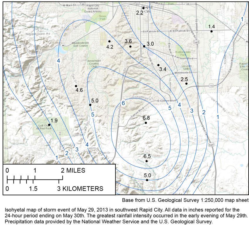
May 29-30, 2013 (Flash Flooding along the eastern Black Hills) Thunderstorms developed along the east side of the Black Hills from Nisland to Sturgis to Rapid City. As these storms moved toward the northwest, they quickly redeveloped and became anchored over the eastern foothills. Rainfall amounts over six inches fell within a few hours. Flash flooding was reported in Rapid City, Sturgis, and rural areas of Butte, Meade and Pennington counties. Runoff from the rainfall quickly inundated city streets, overflowed small creeks, and caused a few private stock dams to breach. Flooded rivers included Horse Creek, Indian Creek, Rapid Creek, Willow Creek, Whitewood Creek and the Belle Fourche River. The Bismark Bridge over the Belle Fourche River east of Vale had two feet of water over it. Around Rapid City, flooding was reported along Sheridan Lake Road in the Spring Brook Acres area; Fifth Street was flooded south of Minnesota St and south of Catron Blvd; Arrowhead and Meadowbrook Golf Courses were flooded with a cart bridge destroyed; water was up to three feet deep against Meadowbrook School; and a few structures along Rapid Creek were flooded near South Valley Drive.
May 31 – June 3, 2013 (Bear Lodge and northern Black Hills) A large upper level low pressure system brought very heavy rainfall to the Bear Lodge Mountains and northern Black Hills. Embedded thunderstorms with rainfall amounts around four to five inches fell within 24 hours. Runoff from this heavy rain caused flooding along the Belle Fourche River, Crow Creek, False Bottom Creek, Redwater River, Spearfish Creek, and other smaller creeks and streams. Culverts were damaged and several county roads were washed out including Red Hill Road near exit 2 at Crow Creek, Sanford Road into Beulah, and Homestake Road at Bear Creek Bridge. The Belle Fourche River near Alva reached a stage of 7.5 ft, which is 3 ft over flood stage and minor flooding was reported in Spearfish Park.
June 21, 2013 (Flash Flood in Oil Creek Fire Scar, Weston County) Flash flooding and debris flows occurred after a half inch to an inch of rain fell in less than an hour over the Plum Creek drainage in the Oil Creek Fire Scar area. West Plum Creek, which is normally dry, suddenly was flowing eight feet deep and 30 feet wide. Plum Creek Road, Big Plum Road, and Oil Creek Road were damaged when water and debris flowed over the roads.
July 8, 2013 (Southwest South Dakota) Flash flooding and debris flows occurred after two to five inches of rain fell in about two hours across southern Custer County during the early morning hours. Runoff from heavy rainfall caused flooding of Cold Brook Creek above Cold Brook Reservoir and Cottonwood Springs Creek above Cottonwood Reservoir. Debris flowing down Cold Brook Creek piled up in the channel along Argyle Road causing water to flow over Argyle Road. The debris filled five dump trucks when it was removed. Along Cottonwood Springs Creek, water created a 12-foot wide channel into Cottonwood Reservoir and washed gravel off rural roads.
July 14-15, 2013 (Tripp County) Runoff from three to six inches of rain in a few hours caused flooding in western Tripp County. Highway 44 was flooded in six locations and numerous county roads were damaged.

Flooding on Pahapesto Rd in Tripp County, July 15, 2013 (photo courtesy of Tripp County)
July 28, 2013 (Weston County) Runoff from three to six inches of rain caused localized flash flooding in southern Weston County along Lion Creek. This flash flood washed away two pole barns and their contents, the contents of a nearby shop, and collapsed the foundation of a ranch house. Lynch Road was overtopped at Lion Creek, damaging the culvert and downstream side of the road.
July 30-31, 2013 (Rosebud Reservation) The failure of Omaha Boy Dam, debris flows from the 2012 Longhorn Fire Complex, and runoff from heavy rain caused flash flooding on the Rosebud Reservation. Debris clogged the outlet works at Ghost Hawk Dam and Rosebud Dam causing the dams to overflow with water. In addition, a breach at Omaha Boy Dam, located about a mile southwest of Rosebud Dam, caused increased inflows into the lake and additional flooding. Several culverts and roads were damaged by the flooding, including Ghost Hawk Road and Grass Mountain Road. The Little White River near Rosebud went from less than 100 cfs to over 1000 cfs in less than four hours, with a peak flow of 1300 cfs.
August 1, 2013 (Wright) Golf ball sized hail and runoff from heavy rain caused flooding of low lying areas in and around Wright, Wyoming. Drainage systems plugged with hail caused flooding of roadways, yards, and basements. The dam on Panther Pond was overtopped; the Wright Golf Course was flooded; and some road, including Wright Blvd and rural roads on the south side of Wright, were covered with two feet of water.
August 3, 2013 (Campbell County) Heavy rainfall of three to five inches fell in a few hours caused minor flooding along rural roads in northern Campbell County. Hail drifts and water covered portions of Sam Adam Road and Broyles Road when drainage culverts were quickly overwhelmed from the excessive runoff. Nearly dry stock ponds quickly filled from the runoff.
August 5-6, 2013 (Rapid City) Two to three inches of rain fell in less than an hour near the Rushmore Mall in Rapid City just before midnight on August 5. Runoff from the heavy rainfall caused minor flooding at maple and Disk Drives and washed a car into a ditch. At the intersection of Crestwood and Racine, rapidly rising water flooded adjacent backyards and basements. In Rapid City near the fairgrounds, Rapid Creek was a foot from exceeding its banks. The water quickly receded, within twenty minutes at most locations.
August 7, 2013 (Fall River and Weston Counties) Runoff from heavy rain, two to three inches in less than an hour, caused flash flooding in eastern Weston County and northern Fall River County. In Fall River County, flooding was reported in Hot Springs, around Cold Brook Reservoir, and in the Minnekahta Valley area. Six inches of water was flowing down Highway 18 and water was over the curbs on a couple of streets in Hot Springs. Minor flooding occurred in Hot Brook Canyon along Hot Brook Creek. Cold Brook Reservoir reached its second highest pool level to date at 3585.42 ft. In Weston County, flooding was reported along Skull Creek Road, Oil Creek Road, Green Mountain Road, and Purvis Road. On the north side of Highway 16 west of Newcastle, ponding water was close to overflowing the highway. North of Four Corners, 1.5 inches of rain fell in 20 minutes.
August 9-10, 2013 (Campbell County) Porcupine Creek, Spring Creek, and their tributaries flooded Highway 59 in spots for nine miles as runoff from heavy rainfall overwhelmed culverts and caused flooding in southern Campbell County. Highway 59 had to be closed from seven miles south of Wright to the Converse County line due to flooding.
August 13, 2013 (Southern South Dakota Heavy Rain) A large area of heavy rainfall fell across portions of southern South Dakota. Rainfall estimates of two to three inches fell in two hours, with some locations receiving an inch in a half hour. Runoff from this rainfall caused ponding of water, minor flooding of low-lying areas, and small creeks to overflow their banks. Runoff from 2.15 inches of rain south southeast of Kadoka caused minor flooding along Pass Creek in Jackson County. In Fall River County, three miles north northwest of Hot Springs, 0.93 inches of rain fell in 30 minutes, with ¾ inch in 15 minutes. The heavy rain caused water to briefly run over the two low water crossings in Hot Springs. Cold Brook Creek backed up behind Argyle Road and covered the Campground Road with a few inches of water at Cold Brook Reservoir.
August 27-28, 2013 (Perkins/Ziebach County) Flash flooding and flooding occurred during the evening of August 27 and continued through the morning of August 28 after three to six inches of rain fell over central Perkins and northern Ziebach Counties. Flash flooding was reported along Thunder Butte Creek, Hart Creek, Twin Butte Creek, Worthless Creek, Beaver Trap Creek, and their tributaries. Rural roads were flooded when culverts were quickly overwhelmed from the excessive runoff.
August 30, 2013 (Rapid City) Runoff from over an inch of rain in less than an hour from slow moving thunderstorms caused street flooding in Rapid City. Rapid Creek quickly rose into the greenway through town. Most roads from West Blvd. to Mt. View were flooded from curb to curb and several other roads and intersections were flooded including Soo San Drive and the intersection of West Blvd. at St. Joseph Street.
September 7-8, 2013 (Northwestern South Dakota) Slow moving thunderstorms over northwestern South Dakota produced significant rainfall amounts of two to six inches within a few hours. Runoff from this heavy rain caused flash flooding along the Grand River and its smaller tributaries. Several roads were inundated when culverts were overwhelmed or damaged from the significant runoff. Water inundated most roads, driveways, and fields in northeastern Harding and northern Perkins Counties. Localized street flooding was reported in Lemon. Five to six inches of rain was reported west of Lodgepole, five inches northeast of Ralph, 3.7 inches in Ludlow, three to five inches around Bison and Shadehill Reservoir, and two to three inches around Lemmon. Shadehill Reservoir rose over 2.5 feet from September 8-14 from the excessive runoff.
October 11-17, 2013 (Western South Dakota) Heavy rain fell on melting snow remaining from the October 4-5 blizzard causing flooding over portions of western South Dakota. Liquid equivalent precipitation amounts over four inches were common over the northern and central Black Hills and eastern slopes from the blizzard, with additional rainfall of two to three inches on October 10-11. In Keystone, law enforcement reported water over the road at several locations along Winter Street and Highway 16A. Battle Creek in Keystone mainly remained within its banks; however, Grizzly Bear Creek overflowed its banks in several locations. Flows in Grizzly Bear Creek were estimated around 500 cfs with around 1300 cfs estimated in Battle Creek. Normal flows for Battle Creek and Grizzly Bear Creek during October is less than 5 cfs.
Flooding of several rural roads and agricultural land occurred due to runoff from heavy rain combined with melting snow. (Harding, Perkins, Butte, Meade, Ziebach, Lawrence, Pennington, Haakon, Jackson, Custer, Fall River, Shannon, Bennett counties). Small streams and creeks quickly overflowed their banks. Normally dry creeks quickly inundated culverts and caused flooding. (Harding, Perkins, Butte, Meade, Ziebach, Lawrence, Pennington, Haakon, Jackson, Custer, Fall River, Shannon, Bennett counties). The duration of the flooding was exasperated by an additional storm system on Sunday October 13th through Tuesday October 15th which brought an additional one to two inches of precipitation.

Flooding in Keystone, October 11, 2013 (photo courtesy of the Pennington County Sheriff's Office).
March 10-16, 2014 (Northwestern and South Central South Dakota) Warm temperatures led to ice break-up and several ice jams. Water from the ice caused minor flooding along the Little Missouri River, Moreau River and White River. The river gage at Camp Crook, along the Little Missouri River crested at 16.2 ft or 4.2 ft above flood stage. Flooding of outbuildings and agricultural land occurred. The river gage along Highway 73 northwest of Faith at the Moreau River crested at 17.4 ft or 1.4 ft above flood stage. Flooding of agricultural land occurred. The river gage southwest of Oacoma along Highway 47 at the White River crested at 16.3 ft or 1.3 ft above flood stage. Flooding of agricultural land occurred.
May 24, 2014 (Gillette-Campbell County Airport) Over five inches of rain fell in less than five hours on the north side of Gillette, WY. Runoff from this heavy rainfall overwhelmed drainage systems which flooded several roads. Highway 59 north of Gillette was flooded in two locations. The Gillette-Campbell County Airport had to be closed due to Airport Road being flooded. A few cars were also damaged while trying to drive through Foothills Blvd when it was overtopped by flood waters. A record daily rainfall of 5.21 inches was set at the Gillette Campbell County Airport. The period of record for the Gillette Airport is 1998 through 2014. The Gillette Cooperative Station, southeast of Gillette, has weather records dating to 1902. The record maximum rainfall for the Gillette Cooperative Station is 4.10 inches set on June 22, 1964.
May 29, 2014 (Sturgis and Bear Butte) In less than four hours, two to five inches of rain fell over Sturgis and Bear Butte, SD. Runoff from this heavy rainfall overwhelmed drainage systems and small creeks, causing minor flooding. Runoff from heavy rain caused street flooding in Sturgis. Several homes had water in their basements. Minor flooding was reported along Spring Creek at Highway 34. A drainage channel that splits South Baldwin Rd and Hillside Drive left its banks and flooded Harmon Street and Hillside Drive in Sturgis.
June 16, 2014 (South Fork Bad River) Runoff from strong thunderstorms caused minor flooding east of Cottonwood. Water Creek, a tributary to the South Fork of the Bad River, covered Cottonwood Road. The South Fork of the Bad River crested at flood stage 4 miles east of Cottonwood, causing minor pastureland flooding.
June 17-19, 2014 (Northwest South Dakota) An area of low pressure over northeastern Wyoming interacted with a stationary surface boundary across western South Dakota to produce slow moving thunderstorms. With ample low level moisture in place, these slow moving thunderstorms produced torrential rainfall. Between three and six inches of rain fell across portions of Harding and northwestern Butte counties on June 17. The runoff from these storms and runoff from additional rainfall on June 18 and June 19 caused significant flooding across Butte, Harding, Perkins, Ziebach, and Meade Counties. Several roads were inundated by flood waters including Highway 85 between Belle Fourche and Redig, Highway 168, Harding Road, and Camp Crook Road. Highway 85 north of Belle Fourche was flooded at Battle Creek, and two motorists drove into the floodwater. Five people were rescued and one person perished.
June 27-28, 2014 (Perkins County) Slow moving thunderstorms produced locally heavy rainfall of two to five inches. Several county roads, including Zeona Road and Prairie City Road, were flooded. At Shadehill Campground water was flowing over roads and quickly flooded campsite pads.
July 22, 2014 (Crook County) Over an inch of rain fell in less than an hour. Runoff from this heavy rain combined with hail, produced flooding across a portion of Crook County. Several county roads flooded including Miller Creek Road and Warren Peak Road. Street flooding was reported in and around Sundance.
August 5, 2014 (Rapid City) An upper level storm system brought monsoonal moisture into the northern high plains. This upper level moisture combined with low-level southeasterly flow to produce heavy rainfall over portions of South Dakota. Flash flooding occurred in Rapid City and Rapid Valley. Up to 4.45 inches of rain was reported, with most of the heavy rain falling within two hours. Flooding occurred on numerous streets in Rapid City. Water depth was mainly four to six inches over the road surface; however, a few locations were covered with water in excess of two feet. Box Elder Creek was over Nemo Road, Haines Ave at I90 had to be closed, the track at the Black Hills Speedway was underwater, and several basements were flooded. Other flooded locations around Rapid City included East Blvd near the railroad tracks, Maple Street at I90, portions of the Mall parking lot, Deadwood Ave near Commerce Road, 5th Street near Minnesota St, 5th Street near Catron, Fairmont Street, Racine St, Crestwood St, west Main Street, and locations along the Lime Creek Drainage.
August 9, 2014 (Fall River County) Over an inch of rain fell in less than an hour in the 2012 Myrtle Burn area in Wind Cave National Park. Runoff from this heavy rain, combined with hail, produced flooding on Cold Brook Creek. Argyle Road was overtopped, a few campsites at Cold Brook Reservoir Campground were flooded, and the main road near Cold Brook Reservoir was underwater for a few hours.
August 23, 2014 (Ziebach County) Runoff from heavy rain caused minor flooding of small creeks and rural roads in central Ziebach County, mainly south of Dupree. Four to six inches of rain fell in less than 12 hours over portions of Ziebach County. Rainfall reports included 5.60 inches 10 miles south of Dupree, 5.12 inches in Dupree, and 4.17 inches 15 miles south southeast of Dupree. A new daily rainfall record for Dupree was set on 8/23/2014 with this 5.12”. The previous record was 4.86” on 6/17/2010.
May 13-19, 2015 (Western South Dakota) Eight to twelve inches of snow, with a liquid equivalent of one to three inches of precipitation, fell over southwestern South Dakota and northwestern Nebraska. Several rain events combined with the melting snow, causing flooding in the White River, Cheyenne River, and Bad River basins. Record flooding was recorded along the White River from the South Dakota and Nebraska State Line to northwest of Oglala. The White River was over 200 yards wide and was at least two feet deep on BIA 41 (Red Shirt to Oglala Road). A vehicle was swept off BIA 41 and a family had to be rescued. BIA 32 South of Highway 18 was washed out. A culvert washed out along Highway 27 between the White River Visitor Center and Scenic and the road bed was damaged. Highway 44 and the KOA Campground near Interior were flooded. Along the Cheyenne River at the Wasta rest area north of Interstate 90, water overflowed into the parking lot and surrounded portions of the building.
May 24 – May 28, 2015 (Western South Dakota) Widespread flooding of small creeks and streams occurred across portions of western South Dakota due to runoff from heavy rain. Flooding was reported at Grizzly Bear Creek Crossing on Grizzly Gulch Road with minor flooding in Keystone along Grizzly Bear Creek. Battle Creek was close to the 1880 Train Tracks near Judson Camp and along Old Hill City Road. Moderate flooding occurred along Battle Creek upstream from Hermosa and around Hermosa, with minor flooding all the way down to the Cheyenne River. Battle Creek flooded a portion of Highway 40 west of Hermosa, near Paradise Lane, and was out of its banks along Highway 40 and Playhouse Road. The river gauge on Battle Creek at Hermosa reported a gage height just over 11 ft, which is three feet over flood stage. Downstream from Hermosa, north of Red Shirt, the river gauge recorded minor flooding, causing flooding of agricultural land. Most of the town of Midland, SD was flooded. Minor flooding was also reported along Elk Creek, the White River, South Fork of the Bad River and its tributaries.
Flooding along Battle Creek, May 24, 2015
May 27-28, 2015 (Powder River) Runoff from snowmelt in the Bighorn Mountains, combined with heavy rainfall over the upper portions of the Powder River Basin, caused significant flooding along the Powder River in northeastern Wyoming. Major flooding of agricultural land occurred along the Powder River. The flows along the Powder River were the highest recorded flows since 1978.
May 24 – June 13, 2015 (Spring Creek and Rapid Creek) Extended flooding occurred along Spring Creek and Rapid Creek. Runoff from heavy rainfall caused minor flooding along Spring Creek, upstream and downstream from Sheridan Lake, and along Newton Fork northwest of Hill City. Releases from Pactola Reservoir were at a historic high of 500 cfs. These high releases, combined with heavy rainfall, caused minor flooding along Rapid Creek downstream from Pactola Dam to the Cheyenne River.
Runoff from several heavy rain events caused very high streamflows and flooding through the first half of June. During this time, several roads were flooded. North of Rapid City 143rd Ave north and south of Neva Way was underwater. Other flooded roads included Reservoir Road, Green Valley Drive between Reservoir Road and Greenfield Road, South Valley Drive, east end of Dunn Road, Anderson Road, South Radar Hill Road, and Antelope Creek Road in Rapid Valley. In Box Elder and to the east, Elk Vale Road near the Flying J, 155th Street south of Highway 14-16, and the South Ellsworth Road Bridge. East of Caputa to Highway 44, Hammerquist Road and 157th Street had to be closed. Around Hill City, Palmer Gulch Road had to be closed due to flooding. Old Hill City Road east of Hill City, Deerfield Road at Marshall Gulch, Allen Gulch Road, Needles Highway from Playhouse Road to Sylvan Campground were flooded in various areas. Golf course at Hart Ranch sustained flooding and Spring Creek washed on the low steel at the Mulligan Mile Crossing. Flood debris caused damage to the foot bridges at Hart Ranch. In Magic Canyon, high flows damaged private bridges. Damage estimates were over $500,000.
June 1, 2015 (Piedmont and Elk Creek) Up to seven inches of rain fell over the Piedmont area in less than three hours. Runoff from this heavy rain damaged buildings, homes, streets, and forced the closure of Interstate 90 for several hours. Interstate 90 around mile marker 44 and Sturgis Road in Piedmont were covered with a few inches of water. Box Elder Creek overflowed its banks with flood waters reaching the right lane of Eastbound I-90. The Piedmont Valley Elementary School sustained significant damage. Flooding along Elk Creek inundated yards, homes and roads in the Golden Valley Subdivision, covered Elk Creek Road between Elk Vale Road and Antelope Creek Road, and flooded agricultural land.
June 3-5, 2015 (Campbell County) Several inches of rain fell in less than two hours in west central Campbell County. Runoff from this rainfall caused water and debris to flow over Interstate 90 near mileposts 90 and 91 between Gillette and Buffalo. Water covered several portions of the Buffalo Cut Across Road west of Gillette. Gravel was washed off the road and large pieces of debris washed across the road. Runoff from the heavy rain also caused minor flooding of hay fields along the Little Powder River in northern Campbell County.
June 4-5, 2015 (Interior) Runoff from three inches of rain in the Badlands caused minor flooding along the White River. Flows in the White River near Interior were around 11,400 cfs.
June 5, 2015 (Lawrence County) Several inches of rain fell in less than two hours in northwestern Lawrence County. Runoff from this rainfall caused water and debris to flow over Highway 14 between mileposts 1 and 2 between Spearfish and Beulah.
June 4-8, 2015 (Fall River County) Widespread flooding was reported along most of southern Fall River County. Almost all tributaries of Hat Creek, Horsehead Creek, and the Cheyenne River from Angostura flooded. Record flooding occurred at the river gauge on Highway 71 at Hat Creek. Indian Creek, just west of Ardmore, was ¼ mile wide. The approach to the County Road 5 Bridge was overtopped. Road washouts were reported in Hay Canyon between Shady Road and Ash Road, North Butte Road, Edgemont Road, and Maitland Road. Horsehead Creek was 200 yards wide and covered the northbound lanes of Highway 385 with a foot of water. Due to the high inflows into Angostura Reservoir, the Bureau of Reclamation released 18,000 cfs from Angostura Dam. This was the highest intentional release ever from Angostura Dam. The town of Oral flooded due to a plugged culvert along Sand Creek. East Oral Road was underwater with several homes and businesses in Oral and north of East Oral Road inundated. Road damage was at least $65,000.
June 6, 2015 (Hill City) Two to four inches of rain fell in less than two hours over Hill City. Most streets in Hill City were flooded. Railway Ave and East Main Street had flood waters at least a foot deep. Several roads were damaged due to the flooding including the Major Lake Drive, Chute Rooster Drive and Smokey Drive.
June 6-9, 2015 (White River Oglala Lakota County) Minor flooding of agricultural land along the White River. Estimated flows along the White River were around 4500 cfs; normal flow is around 50 cfs.
June 7-8, 2015 (Battle Creek) Minor flooding of agricultural land occurred along Battle Creek around Hermosa. The river gauge on Battle Creek at Hermosa exceeded flood stage by 2.4 feet.
June 9, 2015 (Spring Creek) Slow moving thunderstorms produced one to three inches of rain over Spring Creek below Sheridan Lake. Streamflow along Spring creek went from 500 cfs to 900 cfs in less than an hour. After the rain ended, Spring Creek quickly receded.
June 9-11, 2015 (Cheyenne River) High releases from Angostura Reservoir combined with runoff from heavy rain to cause flooding along the Cheyenne River upstream from Lake Oahe. Minor to moderate flooding of agricultural land occurred along the Cheyenne River.
June 10, 2015 (Weston County) One to two inches of rain fell in less than 30 minutes over the Oil Creek Fire Burn Scar. Portions of some county roads were underwater northeast of Osage including Skull Creek Road.
June 17-18, 2015 (Northeast Wyoming) One to two inches of rain fell in less than an hour over Campbell, Crook and Weston Counties. Two to three feet of water was reported over Wind Creek Road. The road was washed out in eight places. Clayspur Road in Weston County also washed out in several places.
June 18-20, 2015 (Western South Dakota) Runoff from heavy rain combined with already saturated soils, caused flooding along Rapid Creek in Rapid Valley, White River in Oglala Lakota County, and along the Cheyenne River near Bridger. Several roads in Rapid Valley had to be closed due to flooding. Rapid Creek flooded South Radar Hill Road cutting off access to a few homes and Dry Creek covered Bradsky Road, cutting off access to around 45 homes. A culvert and a bridge were washed out along Antelope Creek Road along Dry Creek. Minor flooding of the White River between the South Dakota/Nebraska State and Highway 18 and minor to moderate flooding of agricultural land occurred along the Cheyenne River.
June 23-25, 2015 (Pennington County) Strong thunderstorms over western and central Pennington County dumped three to four inches of rain during the evening and overnight hours of June 23-24. In Rapid Valley, Green Valley Drive was flooded for 1/4 mile and Anderson Road was impassable. Flooding was also observed at two gaging stations along Rapid Creek. The river gauge near the Rapid City Wastewater Treatment Plant crested 2.1 feet over flood stage and the river gauge at Farmingdale crested 0.9 feet over flood stage. Runoff from heavy rain caused flooding along Spring Creek between Hill City and Three Forks and between Hart Ranch and Highway 79.
June 25-26, 2015 (Weston County) One to three inches of rain fell across southern Campbell and Weston counties. The runoff caused flash flooding and flooding which inundated or washed out a few roads in southern Weston County. Hay Creek flooded Dewey Road between Highway 85 and the South Dakota Border. Lynch Road near the AU7 Ranch was washed out. Spring Creek washed out the culvert and road on Spring Creek Road.
June 25-26, 2015 (Battle Creek) Minor flooding of low-lying areas along Battle Creek from Hermosa to the Cheyenne River. The river gage on Battle Creek at Hermosa crested at 9.3 feet which is 1.3 feet above flood stage. The gage downstream closer to the Cheyenne River crested 0.2 feet above flood stage.
July 5, 2015 (Martin, SD) Four inches of rain fell in less than two hours northeast of Martin. Several areas of fencing were washed out and water covered a driveway about three miles east of Martin.
July 7, 2015 (Perkins County) Four to six inches of rain fell within a few hours during the evening of July 7. Runoff from these slow-moving thunderstorms produced flash flooding in the Lodgepole Creek Basin flooding roads, yards, and pastures, and causing stock dams to overflow. Haynes Road and 113th Street was inundated for a couple of hours. Rainfall reports included 5.9 inches ten miles east-southeast of Lodgepole and 4.75 inches eight miles east-southeast of Lodgepole.
July 15-16, 2015 (Rapid and Spring Creeks) Minor flooding occurred along Rapid Creek and Spring Creek after two days of heavy rainfall on already saturated soil conditions. Along Spring Creek, a small amount of water covered the entrance road near Hart Ranch. Minor flooding occurred along Rapid Creek above Victoria Creek. The river gage on Rapid Creek above Victoria Creek crested just above flood stage.
July 26, 2015 (Perkins County) During the evening of July 26, slow moving thunderstorms with torrential rain, strong winds, and large hail impacted parts of Harding and Perkins Counties. Trained spotters reported 3.07” of rain within two hours. Many roads flooded and several sections of fences were damaged, especially near Duck Creek, southwest of Lodgepole.
July 27, 2015 (Rapid City) Runoff from a severe thunderstorm caused minor street flooding in eastern Rapid City. Water covered streets and parking lots between Elk Vale Road and Concourse Drive.
September 22-23, 2015 (Tripp County) Flash flooding occurred from runoff of three to five inches of rain in less than six hours south of Colome. Water overflowed 290th Street west of Highway 183. Dry stock ponds quickly filled and gravel was washed off some of the gravel roads in the southern portion of the county.
May 20, 2016 (Custer State Park and Keystone) Three to four inches of rain fell in three hours over a portion of the central Black Hills in Custer State Park, Mt. Rushmore and Keystone. Runoff from this heavy rainfall caused flash flooding and flooding in and around Keystone. Grizzly Gulch Road was underwater and impassible where Grizzly Bear Creek intersects the road. Iron Creek was out of its banks at Needles Highway with three to four inches of water covering the highway. All water crossings on Iron Creek Trail 15 were either damaged or destroyed, making the trail impassable for several weeks. Iron Creek was out of its banks upstream and downstream from Lakota Lake, causing minor flooding of areas along the creek. A road downstream from Lakota Lake overtopped when an eight foot in diameter culvert wasn’t able to keep up with the flood waters.
May 22-23, 2016 (Tripp County) Severe thunderstorms over south central South Dakota produced tornadoes, large hail, strong winds, and very heavy rainfall. Runoff from the heavy rain caused flooding in Colome. Street flooding occurred in Colome and several county roads in the southeastern and far southern portion of Tripp County were inundated and had to be closed.
July 1-2, 2016 (White River Flooding in Southwest South Dakota) Numerous showers and thunderstorms produced very heavy rain across southwestern South Dakota. Two to four inches of rain fell during the afternoon of July 1. Runoff from the heavy rainfall caused flooding along the White River. Minor flooding was reported along the White River. The river rose over 10 feet and went from 50 cfs to 11,900 cfs within six hours. The river gage on the White River near Interior crested at a gage height about ½ ft above flood stage. A cooperative observer in Oral measured 2.06 inches of rain in six hours and the observer in Kyle measured 3.65 inches in 24 hours, most of which fell within 6 hours.
July 3, 2016 (Rapid City) Redeveloping thunderstorms within three hours brought one to two inches of heavy rain to the Rapid City area. Runoff from the rain caused minor street flooding in Rapid City. Water was reported over Main Street near Baken Park, Mount Rushmore Road around the Wilson Park area, 5th Street between Minnesota and Catron, and East St. Patrick Street near Creek Drive. Water also filled the dugouts at the Post 22 Ball Park.
July 15, 2016 (West Rapid City) An isolated thunderstorm produced very heavy rain across portions of the Central Black Hills. Rainfall amounts of two to five inches fell in less than three hours. Runoff from the heavy rainfall overwhelmed culverts and caused flash flooding in Wild Irishman Gulch, Red Rock Canyon, Cleghorn Canyon, and Nameless Cave Canyon. Several feet of water was reported flowing through Wild Irishman Gulch. An observer in Hisega measured 4.11 inches in 1.5 hours, 3.49 inches of rain was reported in 2.5 hours 5.4 miles southwest of Rapid City, and 3.08 inches of rain was reported in three hours at an automated river gage in Johnson Siding.
July 22-23, 2016 (Haakon County) Thunderstorms produced very heavy rain across portions of southeastern Haakon County. Water from Mud Creek rose and flooded a driveway and at least one basement. Water also washed gravel off several county roads including 224th Street, 225th Street, 226th Street, 240thAve, 241st Ave, and 243rd Ave. The Bad River near Midland rose over five feet within two hours.
July 26, 2016 (Mellette and Todd Counties) Thunderstorms produced very heavy rain across Mellette and Todd counties. Rainfall estimates were between 1.5 to 2.5 inches in a couple of hours. Street flooding was reported in Mission and gravel was washed off roads northeast of Mission.
July 31, 2016 (Harding County) Severe thunderstorms produced very heavy rain across northern Harding County. Dry creeks quickly became raging rivers within a matter of hours. Runoff from heavy rain inundated parts of Cox Rd and Clarkson Rd. Gravel was washed off other rural roads between Ladner and Ludlow. An observer 11 miles west-southwest of Ludlow or 15 miles north-northwest of Buffalo reported 4 inches of rain in three hours.
July 27, 2017 (Southern Hills) Redeveloping thunderstorms over the southern Black Hills produced very heavy rainfall over western Custer County. During the morning of July 27, three to five inches of rain fell between Jewel Cave, Custer, and Pringle. Runoff from the heavy rain washed gravel off of several county roads. On Pleasant Valley Road, about 6 miles southwest of Custer, water flowed over the road due to the accumulation of debris from slash piles in the road ditch. The Custer ASOS reported 3.36” in six hours and Jewel Cave measured 4.21” in six hours.
July 27, 2017 (Crook County) Slow moving thunderstorms produced very heavy rain across portions of northeastern Wyoming. About three to four inches of rain fell during the afternoon of July 27. Runoff from the heavy rainfall caused Highway 14 between Moorcroft and Carlile to be flooded for about an hour.
August 14, 2017 (Oglala Lakota County) Flooding along Porcupine Creek flooded driveways and rural roads. A family was stranded at St. Paul’s Church overnight due to the flooding.
August 25, 2017 (Ziebach County) Slow moving thunderstorms produced very heavy rain across portions of southern Ziebach County. Three to six inches of rain fell within three hours between Highway 212 and the Cheyenne River. Runoff from the heavy rain caused flash flooding along Ash and Rattlesnake Creeks. Water ran over county roads north of BIA 6, including BIA27/Ash Creek Road, and several stock ponds exceeded capacity.
April 14-16, 2018 (Harding County) Runoff from melting snow across southeastern Montana caused minor flooding along the Little Missouri River upstream and downstream of Camp Crook. Minor flooding of pasture land along the river occurred for a couple of days with a peak flow around 4800 cfs.
May 17, 2018 (Fall River County) Runoff from heavy rain caused minor flooding across northwestern Fall River County. Two to four inches of rain in two hours caused minor flooding. Runoff from the heavy rain caused gravel to be washed off a couple of county roads and water ran over at least one county road when the culvert became clogged with debris. The Cheyenne River at Edgemont quickly rose about 5 feet and peaked around 1700 cfs, due to the excessive runoff.
May 18, 2018 (Rapid City) Late in the afternoon, a localized thunderstorm moved over Rapid City and dumped two to three inches of rain in about an hour. Runoff from the heavy rainfall flooded streets and low-lying areas. Rapid Creek quickly rose and overflowed its banks near the Fairgrounds. In Rapid City, several water rescues were performed by the fire department. The heaviest rainfall fell over the Robbinsdale area, where the runoff filled a detention pond near the park and tore up sections of asphalt on Fairlane Drive. Several vehicles were pushed by the rushing water and one vehicle ended up in the Robbinsdale Park detention pond. The detention pond was reported to be over 30 feet deep.
May 22, 2018 (Rochford) Runoff from heavy rain caused minor flooding around Rochford. The South Fork of Rapid Creek was out of its banks approximately three to six miles west northwest of Rochford. Several fields were covered with deep hail and water.
May 27-31, 2018 (Black Hills Area) Four days of strong thunderstorms produced heavy rainfall, and saturated soils in and around the Black Hills. The runoff caused minor flooding in several areas in and near the Black Hills along the Wyoming and South Dakota Border. Several small streams overflowed their banks and overwhelmed culverts in Crook and Butte Counties. There was street flooding in Belle Fourche. Roads were flooded in and below the 2012 Oil Creek Burn Scar. In Weston County, a few small stock dams breached and small landslides were reported. Localized flooding was reported around Newcastle, including Carter Ave, Stampede Dr, Highway 85 at Highway 16, and Morrissey Road across Highway 450 just south of Newcastle. There was widespread flooding across Fall River County. Flooded roads included Edgemont Road northwest of Ardmore, Hard Scrabble Road, Black Banks Road, and Horsehead Road. Numerous small creeks and streams were out of their banks, including Beef Creek, Beaver Creek, Black Banks Creek, Cottonwood Creek, Hat Creek, Plum Creek, Duck Creek, Alkali Creek, Little Cottonwood Creek, and tributaries into Hat Creek, Horsehead Creek, and the Cheyenne River upstream of Angostura Reservoir. Inflows into Angostura went from around 250 cfs to over 4500 cfs in just a couple of days. The high inflows raised the water elevation in Angostura, so releases were increased to around 4,000 cfs for a few days.
June 8, 2018 (Jackson County) Up to three inches of rain fell in a couple hours along and near the White River in central Jackson County. Runoff from the heavy rain caused water to flow across Pass Creek Road and caused Pass Creek, Long Creek, Craven Creek and Eagle Nest Creek to overflow their banks. The White River south of Kadoka at Highway 73 quickly rose about 8 feet and peaked around 8700 cfs, due to the excessive runoff.
June 17-20, 2018 (White and Cheyenne River Flooding) Three to five inches of rain fell over the Badlands and portions of southwestern South Dakota. Runoff from the heavy rain caused minor flooding along the White River from Kadoka to the confluence with the Missouri River and along the Cheyenne River, upstream from Lake Oahe. The river gage near Bridger, along Highway 34 crested, at 17.8 ft or 1.8 ft above flood stage and at 22,000 cfs. The river gage south of Kadoka along Highway 73 crested at 14.0 ft or 1.0 ft above flood stage and at 13,900 cfs. The river gage southwest of Oacoma along Highway 47 crested at 15.6 ft or 0.6 ft above flood stage and at 11,300 cfs. Flooding of agricultural land occurred.
June 22, 2018 (Jackson County) Runoff from brief heavy rainfall caused flooding of BIA 2 at Potato Creek. Water was flowing over the road just east of the Potato Creek Bridge. The runoff also caused street flooding in the Potato Creek Community.
June 22, 2018 (Rapid City) Over ¾ of an inch of rain fell in less than an hour, causing street flooding around Rapid City. Several intersections and roads were covered with water throughout Rapid City including west Main Street, Mountain View Road, and Fairmont Street.
July 17, 2018 (Crook and Lawrence Counties) Runoff from slow moving thunderstorms caused flash flooding. Rainfall amounts ranged from a quick two inches to over five inches within a few hours. Flash flooding occurred around Beulah, with normally dry areas quickly filling with water after two to three inches of rain quickly fell in an hour. Sand Creek south of Beulah flooded the Sand Creek Campground and a nearby river gauge recorded a peak flow around 150 cfs. Flows along Redwater Creek increased by 1,000 cfs within two hours. Additional flash flooding occurred in northern Crook County near the Montana border when five inches of rain fell in a few hours. Photos of Thompson Creek showed the creek was over ½ mile wide with water covering hundreds of acres of agricultural land. Several stock ponds failed and most roads in the area were inundated and damaged.
July 17, 2018 (Keystone) Runoff from heavy rainfall, exacerbated by hail covered roads, caused flash flooding in and around Keystone. Water covered Grizzly Gulch Road, parts of Cemetery Road, and several parking lots of businesses along Iron Mountain Road. River levels on Grizzly Bear Creek and Battle Creek quickly rose several feet. The high water caused a campground near Grizzly Bear Creek to be evacuated. The flooding continued for several hours as several rounds of showers followed the strong afternoon thunderstorms. Minor Flooding was observed along Battle Creek and Grace Coolidge Creek upstream from Highway 79. Several pastures and agricultural lands were inundated. The river gauge at Battle Creek at Hermosa just reached flood stage.
July 21, 2018 (Keystone and Rapid City) Runoff from heavy rainfall caused flash flooding in and around Keystone. This flash flooding was exacerbated by the already saturated ground and previous flooding from four days earlier. Water covered Grizzly Gulch Road, parts of Cemetery Road, and parking lots of businesses along Iron Mountain Road again. River levels on Grizzly Bear Creek and Battle Creek quickly rose several feet. Street flooding occurred throughout Rapid City. Water was reported over 3rd St, St. Francis St, Meade St, and West Main Street. Rapid Creek quickly rose and inundated lower portions of the bike path through town. The river gauge near the Water Reclamation facility crested slightly above flood stage with a peak flow around 1,430 cfs.
March 2019 (Western SD) A large blizzard on March 13-14 dumped significant snowfall across the Black Hills and on the plains east of Rapid City. Warmer conditions after the snow, combined with the significant ice cover on the rivers and streams, frozen culverts, and “snow dams” formed by snow sitting in drainage areas, resulted in extensive flooding. The hardest hit area was the White River Basin where roads were washed out, homes were flooded, dams failed, and stream channels were drastically changed by the combination of the ice and runoff from the snowmelt. All of western South Dakota and northeastern Wyoming was impacted by the flooding.
March 23, 2019 (Hidden Timber Dam) During the overnight hours of March 23, Hidden Timber Dam failed along Antelope Creek in the Keya Paha River Basin. As the water made its way downstream, it overtopped several roads along Antelope Creek and the Keya Paha River. A slight rise of around one to two feet was noticed in the gage readings at Keyapaha. However, the snowmelt runoff easily allowed for record levels on the Keya Paha River near Keyapha with flows further downstream near Wewela being the second highest on record.
March 26, 2019 (Quinn Dam) Quinn Dam failed slowly and didn’t result in any significant flooding. It was thought that the partially frozen soils may have kept the dam from failing completely.
March 28, 2019 (Keyhole Dam) The reservoir elevation at Keyhole set a new record pool elevation of 4101.98 ft on March 28, surpassing the previous record of 4100.38 ft set in May of 1978.
May 22-31, 2019 (Western South Dakota) A large storm brought heavy rain and historic late season snowfall to the Black Hills region May 20-22. Significant flooding occurred along the White River, especially from the Nebraska and South Dakota State Line to south of Kadoka, White Clay Creek, American Horse Creek, and Little White River. Highway 44, south of Interior, was covered with water in three locations. Smaller creeks and tributaries within the basin also flooded, especially across Oglala Lakota, Todd, Bennett and Tripp Counties. Several roads and bridges were completely washed out, with most other gravel roads throughout the counties sustaining some form of damage. Flooding was observed on the Bad River from near Cottonwood to east of Midland. The peak gage height on the Bad River at Midland reached a preliminary height of 23.45 ft on May 24. This is the 2nd highest gage height recorded at this location with records dating to 1946. Moderate to major flooding occurred in the Cheyenne River Basin including along Elk Creek, Rapid Creek, Box Elder Creek, Spring Creek and in the Belle Fourche Basin. The peak gage height at the Cheyenne River at Plainview reached a preliminary height of 22.87 ft on May 23 with a peak flow of 61,900 cfs. This gage height is a new record at the location with the 2nd highest discharge ever recorded. Numerous roads were inundated with widespread flooding of agricultural land.
May 26-31, 2019 Coming off major to record flooding the previous week, conditions were primed for additional flooding with strong daily thunderstorms May 26-31st. On Sunday the 26th, heavy rainfall of up to 4" was observed near Faith over the north central South Dakota plains, over 3 inches fell in Sturgis, while 1-2" of rain fell over portions of the White River basin. This was the start of several days’ worth of flooding, which eventually affected much of the South Dakota plains and foothills, along with portions of northeastern Wyoming along the Belle Fourche River and Powder River. The event culminated with heavy rainfall and thunderstorms over the Rapid City area during the afternoon and evening of May 31st, which led to widespread flooded roadways and multiple water rescues.
June 30, 2019 (Northeast Wyoming) Two to four inches of rain fell across Weston and Crook counties, runoff from the heavy rain caused flash flooding. In Crook County, multiple county road culverts were overwhelmed with water and debris, causing water to flow over several county roads. Runoff from the heavy rain also caused water to run over Highway 585. In Weston County, water was over portions of Oil Creek Road, Black Canyon Road, Plum Creek Road, and Skull Creek Road.
July 3, 2019 (Black Hills & southwestern SD) Severe storms with tornadoes, large hail, damaging straight-line winds, heavy rain, and flash flooding occurred in the Central and Southern Black Hills, Oglala Lakota County and in Bennett County. In Lawrence County, runoff from heavy rain destroyed several camping sites at the Boxelder Forks Campground and washed out Forest Service Road 140, Butcher Gulch Road/Forest Service Road 172, and Boxelder Creek Road in multiple locations. In Oglala Lakota County, flooding occurred on Three Mile Creek, Six Mile Creek and their tributaries. Water covered portions of BIA 17 and was alongside BIA 2/Big Foot Trail southwest of Kyle. In Bennett County, water inundated 296th Street and washed out a culvert, causing the road to collapse. In Custer County SD and Weston County WY, Dewey and Dewy Road was flooded. A culvert on Dewey Road near Hay Creek washed out, and Red Creek covered Dewey Road with four to five feet of water. Additional flooding from Line Creek and Pass Creek overtopped Pass Creek Well Road and Pilger Mountain Road.
July 4, 2019 (Deadwood to Sturgis & Rapid City) Severe storms with heavy rain, flash flooding, large hail, tornadoes, and damaging straight-line winds moved across northeastern Wyoming and western South Dakota. Three short-lived tornadoes occurred in the higher Black Hills - one south of Black Fox Campground, one east of Deerfield Lake, and another northwest of Jewel Cave. Considerable damage occurred from flash flooding and flooding in the northern Black Hills and eastern Foothills, impacting Deadwood, Boulder Canyon, Sturgis, and Rapid City. In Lawrence County, the gold course in Boulder Canyon along Bear Butte Creek was flooded for two days, a landslide on Galena Road occurred, and many culverts were blocked by water and debris, Ruby Flats and Englewood roads were flooded, as well as portions of Two-Bit Road and Yellow Creek Road. In Meade County, extensive flooding occurred along Bear Butte Creek from Boulder Canyon through Sturgis to Ft. Meade. Highway 34 at the "S-curves" between Sturgis and Fort Meade were covered with water and impassable, the City Park was completely underwater, and the 7th Street Bridge at Bear Butte Creek was inundated. The Sly Street Crossing, West Woodland Drive, and Blanche Street were damaged and/or washed out, as well as almost all the other crossings over Bear Butte Creek in Sturgis. In Rapid City, multiple vehicles stalled on area roads with several water rescues performed. Portions of Saint Joseph Street near South Dakota School of Mines & Technology was underwater, and water was running curb to curb on Omaha Street, Mount Rushmore Road, West Boulevard, and Main Street.
July 5, 2019 (Sturgis to Rapid City and east) Additional severe thunderstorms kept creek and stream levels high, leading to additional flooding. In Pennington County, there was flooding in north Rapid City near the Mall and minor flooding along Rapid Creek in Rapid City and Rapid Valley. In Meade County, there was flooding along Boxelder Creek around Black Hawk and along Elk Creek north of Ellsworth Air Force Base. Water inundated Peaceful Pines Road between Deadwood Ave and Interstate 90, 143rd Avenue east of Nike Road, Antelope Creek Road around Elk Creek and Antelope Creek, Elk Creek Road between Elk Vale and Antelope Creek Roads, Elk Vale Road north of Elk Creek Road, and Horseshoe Road south of Elk Creek Road.
July 5, 2019 (Fall River County) runoff from heavy rainfall caused flooding along Hat Creek and its smaller tributaries and along Duck Creek and Plains Creek. The flooding compromised a culvert on Highway 71 about 4 miles north of Ardmore and a county road bridge just east of Ardmore.
July 16-17, 2019 (Bennett and Butte Counties) In Bennett County, flooding washed out a culvert on the Little White River at 208th Avenue south of Swett. In Butte County, Highway 79 washed out in two locations – one where Frog Creek crosses the highway and the other at the Hans Creek crossing. The flooding also damaged Erk Road near Goeringer Road, and Erk Road south of Graf Road at Warren Creek. By July 21, the excessive heavy rain from the 16th and 17th, combined with additional rainfall, caused flooding along the South Fork of the Moreau River near Hoover.
August 1, 2019 (New Underwood to Badlands) Strong thunderstorms with heavy rain on already saturated ground, caused flash flooding on the Pennington County plains, east of New Underwood, to Badlands National Park. In Badlands National Park, flash flooding occurred on Sage Creek. Water inundated Sage Creek Road and flooded Sage Creek Campground. About five miles east of New Underwood, flash flooding compromised a culvert under the railroad tracks, which derailed a RCP&E train. Two RCP&E employees were injured and had to be extricated from a partially submerged locomotive.
August 2, 2019 (Custer) A nearly stationary thunderstorm developed over and near Custer, SD during the afternoon. Radar estimates indicated that 6-7" of rain fell to the west of Custer, with measured observations as high as 5.35 inches. Significant flooding occurred on French Creek from the Custer Limestone area, downstream to Stockade Lake, including the City of Custer. The Custer County Sheriff’s Office closed roads and conducted evacuations, before water began to recede. Several other smaller tributaries into French Creek, including Ruby Creek, also flooded. Flash flooding inundated Custer Limestone Road just east of the intersection of Forest Service 284 and Forest Service 285, French Creek Road at Hoover Court, Highway 16, Highway 16A, Highway 89, Custer Street, South 4th Street, French Creek Drive, Gordon Street, 7th Street, 8th Street, Washington Street, Sidney Park, Granite Valley Drive, and Iron Creek Road. Several homes and businesses were also flooded.
August 8, 2019 (Gillette) During the late evening of August 8, runoff from heavy rain caused flash flooding in the coal mines southeast of Gillette. Runoff from over three inches of rain within two hours caused the mine pits at the Caballo Mine and the Belle Ayr Mine to fill with water. Several workers had to be evacuated, due to the flash flooding.
August 10, 2019 (Wewela, SD and Newcastle, WY) During the early morning hours of August 10, runoff from two to three inches of rain caused flash flooding around Wewela. A few roads, including 328th Avenue, 331st Avenue, and 229th Street were inundated and damaged. Later that afternoon, additional thunderstorms caused numerous roads around Newcastle, WY to be flooded. Morrisey Road at Highway 16 was damaged from a culvert washout.
August 11-12, 2019 (Oglala Lakota County) Three to five inches of rain was reported between Porcupine, Sharps Corner, and Kyle. A large amount of the precipitation fell over Iron Cloud Canyon, causing flash flooding of BIA 27 between Evergreen and Gooseneck Road. As the flood waters continued along Porcupine Creek, BIA 2 just east of Sharps Corner was inundated by the next morning. Additionally, flooding on Three Mile Creek and American Horse Creek, stranded livestock, damaged corrals, and flooded several outbuildings and barns. Close by in Bennett County, flash flooding occurred in Yellowbear Canyon, resulting in BIA 4 being inundated for a couple of hours.
May 16, 2020 (Butte County) Prolonged upslope rain showers with embedded thunderstorms dumped three to five inches of rain across portions of northern Lawrence and south Butte Counties. Runoff from this heavy rainfall, combined with saturated soils and steep terrain, led to flooding in southern Butte County. Runoff from heavy rainfall caused water to flow over Crooked Oaks Road, just south of Snoma Road. Gravel was washed off the road and the road was impassable for a couple of hours.
May 23, 2020 (Meade and Haakon Counties) Severe thunderstorms brought large hail and flash flooding to portions of the Black Hills and western South Dakota plains. Runoff from heavy rainfall of 3 to 5 inches caused flash flooding across portions of Haakon and Meade counties. Runoff from heavy rainfall caused water to flow over driveways and rural roads, including Elm Springs Road between the Belle Fourche River and Elm Springs, Torchlight Place south of White Owl, portions of Hilland Road, 210th Street, 227th Street, and 230th Street. Several fields and normally dry drainage areas were flooded.
June 25, 2020 (Custer) Severe storms with heavy rain resulted in flash flooding around Custer. Runoff from heavy rainfall and copious amounts of hail combined to produce street flooding in Custer. The excessive runoff overwhelmed culverts and caused flooding along French Creek upstream of Stockade Lake.
July 29, 2020 (Jackson and Oglala Lakota Counties) Severe storms with heavy rain resulted in flash flooding in portions of southwestern South Dakota. Runoff from heavy rainfall produced street flooding in Manderson and along Wounded Knee Creek. BIA 33 was flooded north of Manderson. Runoff from heavy rainfall washed out a culvert and a 16-foot section of Highway 44 at Fish Creek Road. Flooding occurred along Fish Creek and Pass Creek in eastern Jackson County.
February 2021 (Spearfish, SD) Minor, nuisance flooding occurred on Spearfish Creek from February 16 through February 19. Very cold temperatures (highs below zero) caused Spearfish Creek to freeze from the bottom up. As the entire channel filled with ice, water overflowed the lower banks and flooded areas along the creek. Once the temperatures began to warm, the ice melted, layer by layer from the bottom up, which eventually caused the top layers of ice to collapse, which in turn allowed the water to return to the channel.
June 12, 2022 (Pennington and Haakon Counties) A trailing supercell thunderstorm tracked across northeastern Wyoming and across the northern Black Hills and west central South Dakota. This storm brought large hail to the Spearfish, Lead, Deadwood, and Sturgis areas, as well as portions of the southern Meade County plains into south central South Dakota. Heavy rain resulted in flash flooding across portions of northeastern Pennington and Haakon Counties. Two to three inches of rain fell in a brief period of time. The runoff flooded fields, rural roads, and yards.
July 1, 2022 (Pennington and Meade Counties) A slow moving thunderstorm became anchored over the Box Elder area for close to an hour. The storm was severe at times, producing hail and wind gusts to 70 mph. Heavy rainfall of two to over three inches in Box Elder produced flooding and areas of flash flooding. Over three inches of rain fell in an hour over Ellsworth Air Force Base and parts of Box Elder. Runoff from the heavy rain flooded streets, homes, and businesses. Several streets were flooded on Ellsworth Air Force Base and throughout northern and eastern portions of Box Elder. At least 50 mobile homes were surrounded by water and ten to 15 homes were flooded with water up to six feet deep, mostly along the east side of North Ellsworth Road. Several businesses reported that their parking lots were flooded.
July 24, 2022 (Pennington and Meade Counties/Rapid City) Monsoonal moisture streaming into the area, combined with slow moving thunderstorms, produced a narrow area of heavy rain from Black Hawk to Rapid Valley. Runoff from this rainfall caused minor street flooding on a few city streets in Rapid City, flooded open agricultural fields in Rapid Valley, and caused high flows and minor flooding along Rapid Creek. Two to three inches of rain fell across a narrow area from Black Hawk to Rapid Valley in about two hours. Runoff from this rain caused minor street flooding on the east side of Rapid City as the drainage system in town was overwhelmed. Open agricultural fields in Rapid Valley were flooded with a few inches of water as well. The abundant runoff also caused high flows and minor flooding along Rapid Creek from the Central States Fairgrounds to Bradsky Road.
August 5, 2022 (Mellette and Todd Counties) A line of strong to severe thunderstorms produced gusty winds across portions of Todd County. Monsoonal moisture, combined with training storms, resulted in flash flooding across southern Mellette and northern Todd Counties. Rainfall amounts of three to four inches were reported. Flash flooding quickly occurred as water ponded in fields. Heavy rain washed gravel off rural roads. The Little White River around the confluence with Cut Meat Creek and Oak Creek rose several feet in an hour. Runoff from heavy rain quickly flooded fields and washed gravel off rural roads. The Little White River around the confluence with Cut Meat Creek and Oak Creek rose several feet in an hour.
August 24, 2022 (Custer and Oglala Lakota Counties) A supercell thunderstorm developed over the southern Black Hills and tracked southeast, weakening on the adjacent plains. The storm produced large hail and heavy rain over the area. Other strong thunderstorms produced heavy rain and localized flash flooding over far southwestern South Dakota. Rain amounts of three to four inches were estimated in some areas. In Oglala Lakota County, flash flooding quickly occurred in Porcupine, with water running over roads. In Custer County, Hopkins Flat Road west and northwest of Pringle was washed out.
May 11-12, 2023 (Oglala Lakota, Pennington, Jackson, Haakon, and Ziebach Counties) A prolonged rain event over several days led to flooding and flash flooding over the Cheyenne and White River basins. Three to five inches of rain fell, with some locations receiving nearly four inches of rain within six hours on the evening of May 11. As the water flowed into larger rivers, minor flooding was observed. Flooding along Potato Creek inundated the bridge on BIA2. The heavy rain washed gravel off several tribal roads and water inundated several fields and low-lying areas.
May 17, 2023 (Rapid City) A severe thunderstorm developed just northwest of Rapid City and slowly drifted north and east through portions of the Rapid City, Black Hawk, and Summerset areas, producing hail around quarter size and heavy rain. Brief heavy rain and large amounts of small hail blocked storm drains and caused minor flooding across parts of Rapid City, with elevated stream levels on Rapid Creek east of Rapid City.
June 22-23, 2023 (Red Elm and Dupree) Runoff from heavy rain caused flooding across portions of Ziebach County during the late evening and overnight hours. Flash flooding inundated several county roads, overwhelmed culverts, and caused ponding of water in fields. Four to six inches of rain fell in three hours between Red Elm and Dupree. The water quickly entered Bear Creek, which became about a quarter mile wide; inundating roads, fields, crops, and outbuildings. Water approached a residence near Red Elm and a home near Dupree. Water covered portions of 216th Avenue and 217th Avenue.
June 23, 2023 (Spearfish) A strong thunderstorm produced hail to penny size in Saint Onge and heavy rain across the northern foothills area. Runoff from the heavy rain caused significant flooding in Spearfish and across other portions of northern Lawrence County. Asphalt buckled and gravel washed off numerous roads from the flooding and damaged buildings. Runoff from heavy rain caused considerable damage in Spearfish. Numerous roads flooded and asphalt buckled on portions of Main Street and Jackson Boulevard. The USGS gage, Spearfish Creek at Spearfish, recorded its fifth highest level since 1947 with a flow of 1900 cfs. Damage was reported at several locations, including the DC Booth National Fish Hatchery and a private apartment complex.
June 23-24, 2023 (Rapid City and Box Elder) A thunderstorm briefly became severe in the Rapid City area, producing hail mostly on the south and east sides of the city. Runoff from heavy rain caused flooding along Box Elder Creek. High water along Box Elder Creek flooded agricultural land and low-lying areas. Runoff from heavy rain inundated several county roads, including Antelope Creek Road, New Underwood Road, Brustel Road, and Elm Springs Road. Crop and pasture land were flooded, as well as low lying areas.
August 4, 2023 (Perkins County) Runoff from heavy rain caused flash flooding north and west of Faith. Runoff flooded a few roads and accumulated in several fields and ditches. Runoff from heavy rain caused Arrowhead Road north of Faith to flood. Water also ponded in fields and ditches. Over three inches of rain fell in about two hours.
September 13, 2023 (Custer County) A slow-moving thunderstorm briefly became severe over central Pennington County into north central Custer County, producing hail up to golf ball size along with heavy rainfall. The storm became nearly stationary just west of Hermosa and produced 2 to 5 inches of rainfall in less than 2 hours. Runoff from the heavy rainfall caused several roads to be inundated with water and debris west of Hermosa. Runoff from heavy rain caused flash flooding in Ghost Canyon and Box Canyon, and along Battle Creek and Grace Coolidge Creek, west of Hermosa. Ghost Canyon Road and Battle Creek Road were flooded with water and debris. Water and debris filled the ditches along Highway 40 and Highway 36.
October 13, 2023 (Jackson County) A significant early Fall storm system brought soaking rains to southern and western portions of South Dakota. Minor flooding occurred along the White River in Jackson County, near and downstream from Interior. Runoff from an estimated three to four inches of rain over 24 hours in the Badlands caused minor flooding of the White River around Interior. Agricultural land along the White River was inundated and the water approached highway 44, north of the river. The White River near Interior river gage crested at 14.83 feet and 12,800 cfs at 745 AM MDT.
May 6, 2024 (Gillette) A strong upper-level low pressure moved from the Rockies on May 5, 2024, to the northern plains on May 6-8, 2024. Deep surface low pressure developed over southwestern North Dakota. Ahead of the system, strong gusty southeast winds developed on May 5 pulling in plentiful moisture. As the system strengthened May 6-7, strong northwest winds (up to 79 MPH) developed with heavy, wet snow over the highest Black Hills. Numerous power outages were reported coincident with the snow and high winds. As the two air masses clashed, a line of thunderstorms developed on May 6 in the morning. The thunderstorms produced minor flooding in Gillette, WY. Over western South Dakota, a line of thunderstorms developed – containing isolated severe thunderstorms – with one storm producing two tornadoes near Mud Butte, SD early in the afternoon on May 6. Significant liquid-equivalent precipitation fell. 1 to locally 3” fell over northeastern Wyoming and the Black Hills. Amounts on the western South Dakota plains varied widely with some folks getting very little and others around an inch. 14-18” of snow fell near Four Corners, WY, and O’Neil Pass, SD.
June 20-21, 2024 (Mellette and Tripp Counties) Training thunderstorms dumped 2 to 5 inches of rain in less than 3 hours over portions of south-central South Dakota. Runoff from the heavy rain caused several roads to be inundated with water and debris. Farmland was also flooding due to the intensity of the rain.
August 19, 2024 (Mellette and Tripp Counties) Thunderstorms dumped two to five inches of heavy rain, in less than three hours, over portions of Lawrence County. Runoff from the heavy rain caused minor street flooding in Deadwood and a small portion of Crook Mountain Road to be inundated with water and debris.


