
Active spring pattern across the center of the nation with several rounds of severe thunderstorms in the forecast through the weekend. The regions under the greatest threats are the southern Plains into the Mississippi Valley. Meanwhile, dry and breezy conditions with dry fuels are aiding in wildfires across the western High Plains and the Southeast. Wind and some snow for northern Rockies. Read More >
WATCH: Conditions are favorable for a severe storm or flooding; but the exact timing, location, or occurrence is still uncertain. A watch means to get prepared for the hazardous conditions.
WARNING: Hazardous weather is expected or occurring. A warning means to take shelter.
ADVISORY: Weather conditions that cause inconvenience are expected or occurring. An advisory means to use caution.
TORNADO: A violently-rotating column of air from a thunderstorm in contact with the ground.
SEVERE THUNDERSTORM: A thunderstorm with hail 1 inch or larger and/or winds 58 mph or greater; lightning is not a criteria for a severe thunderstorm as all thunderstorms produce lightning.
FLASH FLOOD: A life-threatening flood that occurs very quickly from intense rainfall over a short period of time, especially in mountainous terrain, or from a dam failure.
FLOOD: Rivers overflowing their banks or water covering a normally-dry area caused by an extended period of widespread rain, snowmelt, or ice jams that develops more slowly than a flash flood.
URBAN AND SMALL STREAM FLOODING: Minor flooding of small streams, streets and low-lying areas such as underpasses and storm drains; generally not as dangerous as a flash flood.
 WINTER WEATHER:
WINTER STORM WARNING: A life-threatening winter storm with snow, ice, strong winds, and/or cold temperatures. HEAVY SNOW is defined as (i) six inches of snow per event for most of northeastern Wyoming and western South Dakota, (ii) seven inches per event in the Central Black Hills, Wyoming Black Hills, Northern Foothills, and Sturgis-Piedmont Foothills, and (iii) nine inches per event in the Northern Black Hills. See image at right.
BLIZZARD: A severe winter storm with winds 35 mph or greater AND significant snow or blowing snow with visibility less than 1/4 mile.
ICE STORM: Ice accumulations that could cause extremely dangerous conditions and significant damage.
WINTER WEATHER ADVISORY: A combination of winter weather conditions such as 3 to 6 inches of snow in 12 hours; or 5 to 8 inches of snow in 24 hours, light freezing precipitation, and/or blowing snow.
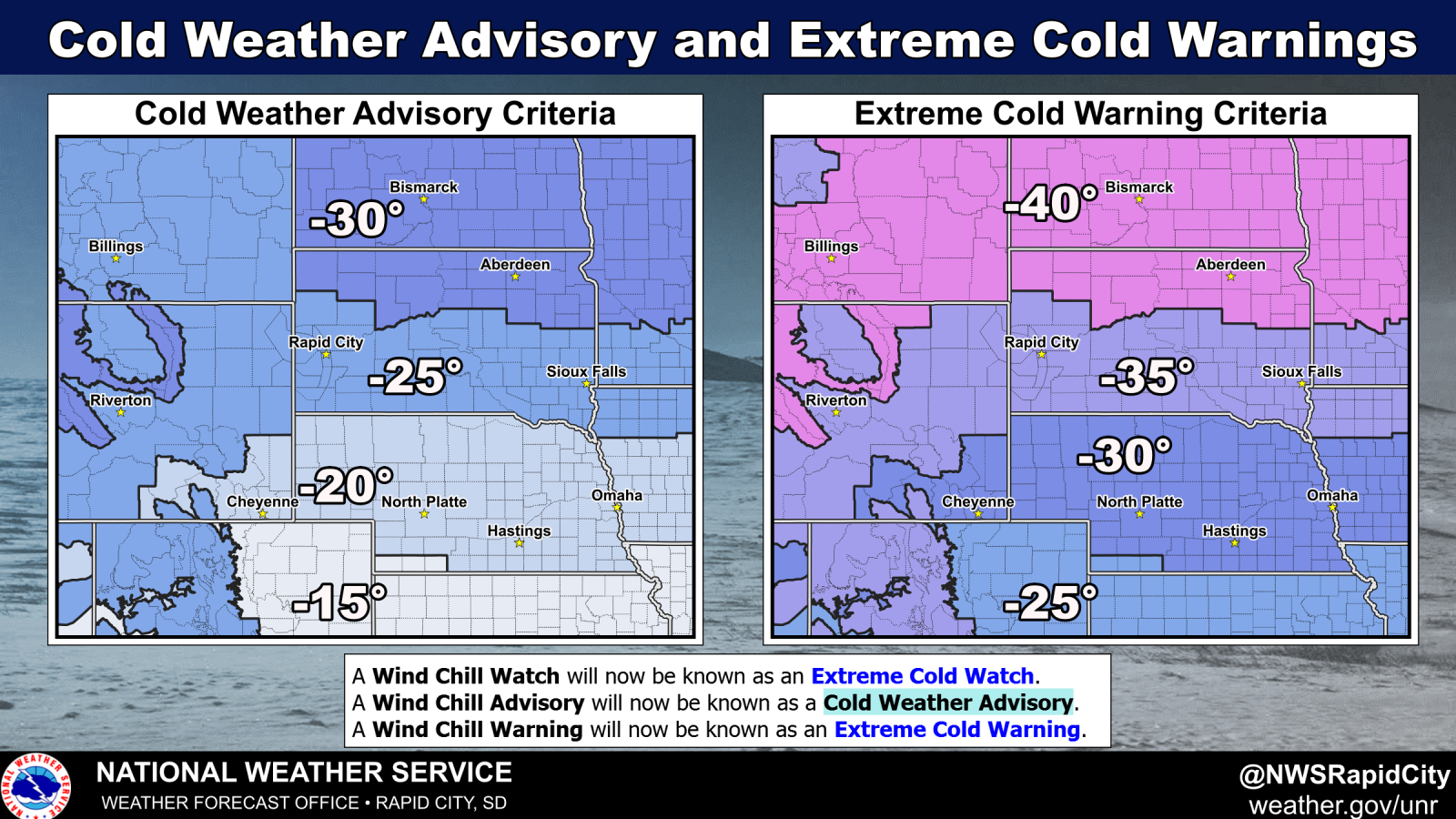
EXTREME COLD WARNING: Apparent temperature values of -35F to -40F or colder that can cause frostbite in only 10-15 minutes. Click for map.
COLD WEATHER ADVISORY: Apparent temperature values between -25 and -40F. Frostbite can occur in 20-25 minutes during those conditions. Click for map.
HIGH WIND WARNING: Winds 40 mph or greater; or wind gusts 58 mph or greater.
WIND ADVISORY: Winds 30 mph or greater; or wind gusts 45 mph or greater.
DENSE FOG ADVISORY: Visibility less than 1/4 mile.
BLOWING DUST WARNING: Visibility less than 1/4 mile over a widespread area.
BLOWING DUST ADVISORY: Visibility between 1 and 1/4 mile over a widespread area.
FREEZE WARNING: Temperatures 32 degrees or colder for a significant period of time that could kill outdoor plants at the beginning or end of the growing season.
FROST ADVISORY: Temperatures in the mid 30s with clear skies, light winds, and high humidity near the ground that could kill outdoor plants at the beginning or end of the growing season.
EXCESSIVE HEAT WARNING: Heat index values 105 F with a minimum heat index of 75 F for 48 hours; or heat index values 100 F for four consecutive days.
HEAT ADVISORY: Heat index values 100 F; or heat index values 95 F for four consecutive days.

