National Weather Service United States Department of Commerce

Areas of Excessive Rainfall and Severe Thunderstorms on Wednesday

Heavy to excessive rainfall may produce additional flash flooding Wednesday across parts of the southern Plains where the greatest risk is along the Red River Valley into western Arkansas. Scattered severe thunderstorms are also possible centered on central Texas to eastern Oklahoma and western Arkansas. Large hail, damaging wind, and a few tornadoes will be possible. Read More >

Mobile Spotter Page Skywarn Logo


Rapid City's Mobile SKYWARN Spotter Page


- Do not use to report tornadoes, flash floods, and other extreme life-threatening situations. Call the National Weather Service to talk to a forecaster directly
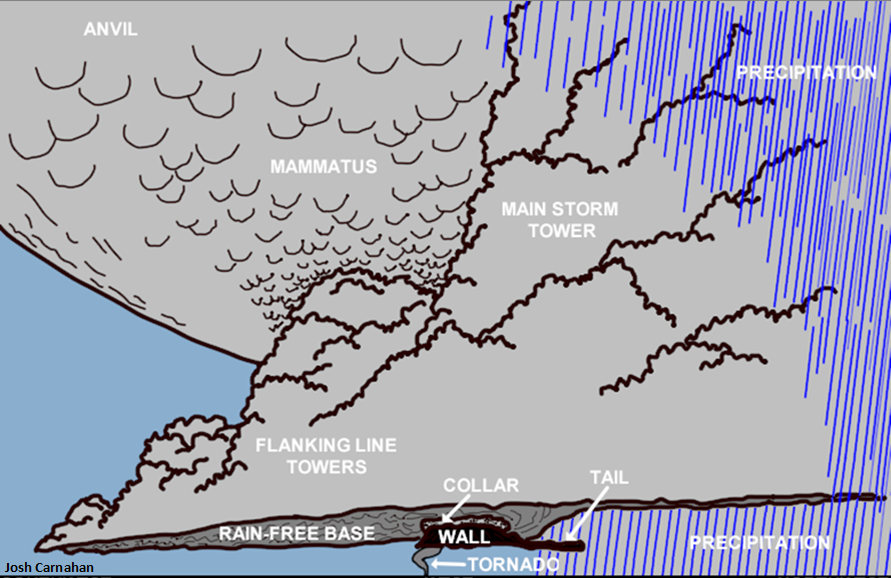

Active Hazards (Click for Details)


Rapid City's Radar (Click for More Images)


North Platte's Radar (Click for More Images)


Local Storm Reports


Severe Weather Outlooks


Day 1


Day 2


Reporting

Information to Report:

  • Tornadoes, funnel clouds, wall clouds

  • Hail: 1/2" or larger (Click here for a ruler)

  • Wind Gusts: 50 mph or stronger

  • Flash Flooding: water depth and movement

  • Heavy Rain: falling at the rate of 1" or more per hour

  • Storm Location & Time Observed

  • Your Identity & Specific Location: street address, latitude/longitude, or distance from an intersection

  • Storm Damage


Reporting Procedures:

  • Notify dispatcher or law enforcement office

  • Activate local warning systems

  • Contact Rapid City NWS:

    • SD State Radio Network: "RAPID CITY WEATHER" on NWS-W talkgroup

    • WYOLINK Radio Network: "RAPID CITY WEATHER" on NWS RC talkgroup

    • 605-341-7435 (local or cell) or 1-800-684-4163

  • Click here to send a report

  • Send pictures to: nws.rapidcity@noaa.gov

  • Send reports from your smartphone with the mPING app (download from your phone's app store)


Thunderstorm Information

Wall Cloud Characteristics:

  • Persists at least several minutes

  • Continuous, organized horizontal rotation

  • Ground-level winds flow toward the wall cloud

  • Upward motion in the base of the wall cloud


    • Wall Clouds Shelf Clouds
      Located below storm updraft Located around storm downdraft
      Toward back of storm At leading edge of storm
      Rotates horizontally Doesn't rotate
      Winds blow toward and upward into wall cloud Winds blow downward and away from shelf cloud

      Wind Speed Estimates

      Description of Damage Speed (mph)
      Large branches move, telephone lines whistle 25-31
      Whole trees move, difficult to walk against the wind 32-38
      Twigs break of trees, wind impedes walking 39-54
      Chimneys and TV antennas damaged, shallow-rooted trees uprooted 55-72
      Roof surfaces peel off, windows break, mobile homes overturn 73-112
      House roofs tear off, weak buildings and mobile homes destroyed, large trees uprooted over 113

      Hail Sizes

      Description of Hail Diameter (inches)
      Pea 1/2
      Penny, mothball 3/4
      Nickel 7/8
      Quarter 1
      Half-dollar 1 1/4
      Silver dollar, ping-pong ball, walnut 1 1/2
      Golf ball 1 3/4
      Tennis ball, snuff can 2 1/2
      Baseball 2 3/4
      Tea cup 3
      Grapefruit 4
      Softball 4 1/2

      Severe Thunderstorm Views

      Looking at the Storm


      Diagram of a Storm


      Helpful Links


      Local Forecasts and Warnings


      Rapid City Skywarn page


      Abridged Spotter's Guide


      PING hail and precipitation reports


      Local NOAA Weather Radios


      Definitions

      WATCH: Conditions are favorable for severe thunderstorms, tornadoes, or flash floods.


      WARNING: A severe thunderstorm, tornado, or flash flood is imminent. The storm has either been reported by spotters or detected by the radar.


      SEVERE THUNDERSTORM: A thunderstorm with hail at least 1 inch in diameter and/or winds of 58 mph or stronger.


      NWS Rapid City Social Media