
A heat wave over the Southwest will intensify this week, peaking and expanding into the Intermountain West and northern High Plains this weekend. Critical to extremely critical fire weather conditions are forecast from the Northwest and the northern Great Basin this weekend. Particularly Dangerous Situation Red Flag Warnings have been issued. Read More >
Overview
|
A significant October storm system brought soaking rains to southern and western portions of South Dakota, and parts of northeastern Wyoming. Light accumulations of snow were observed across the higher elevations of the Black Hills. Some minor flooding of the White River occurred across Jackson County near and downstream from Interior. |
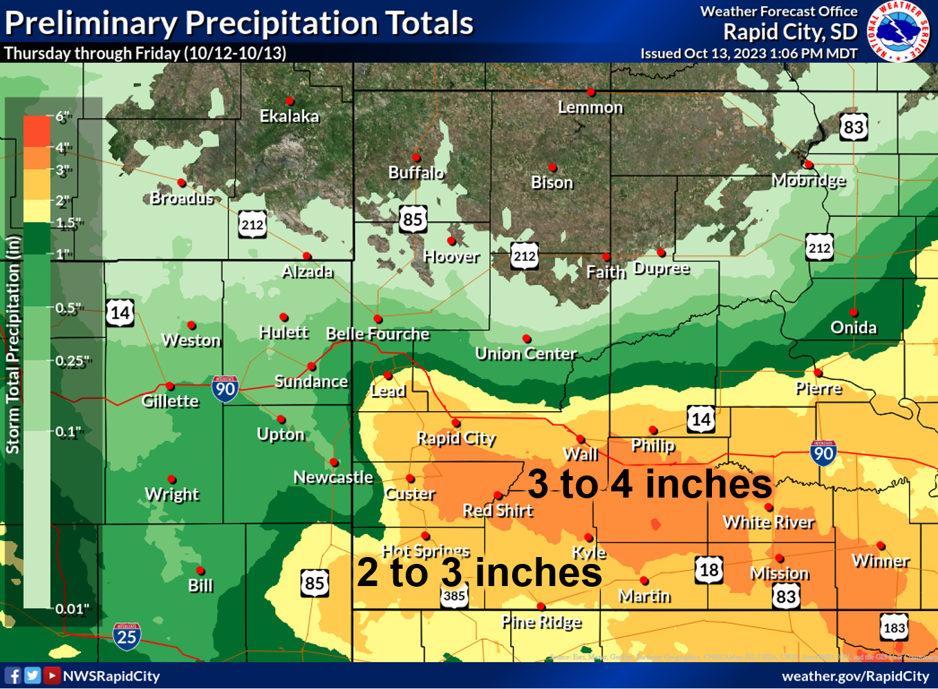 Estimated precipitation amounts from Thursday morning through Friday noon. |
Minor Flooding
Rainfall amounts of 3 to 4 inches along a good portion of the White River produced some minor flooding in and below the Interior area.
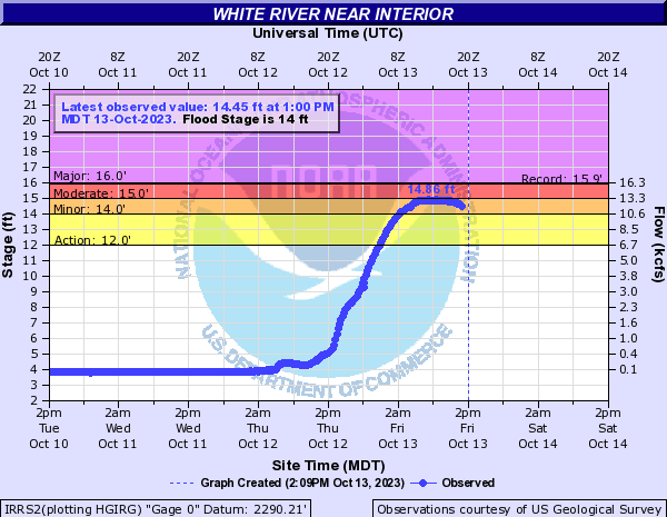
Hydrographs
 |
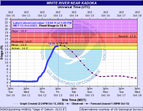 |
| Minor flooding along the White River near Interior Friday afternoon. | Minor flooding expected along the White River near Kadoka through Friday night. |
Photos
.jpg) |
.jpg) |
.jpg) |
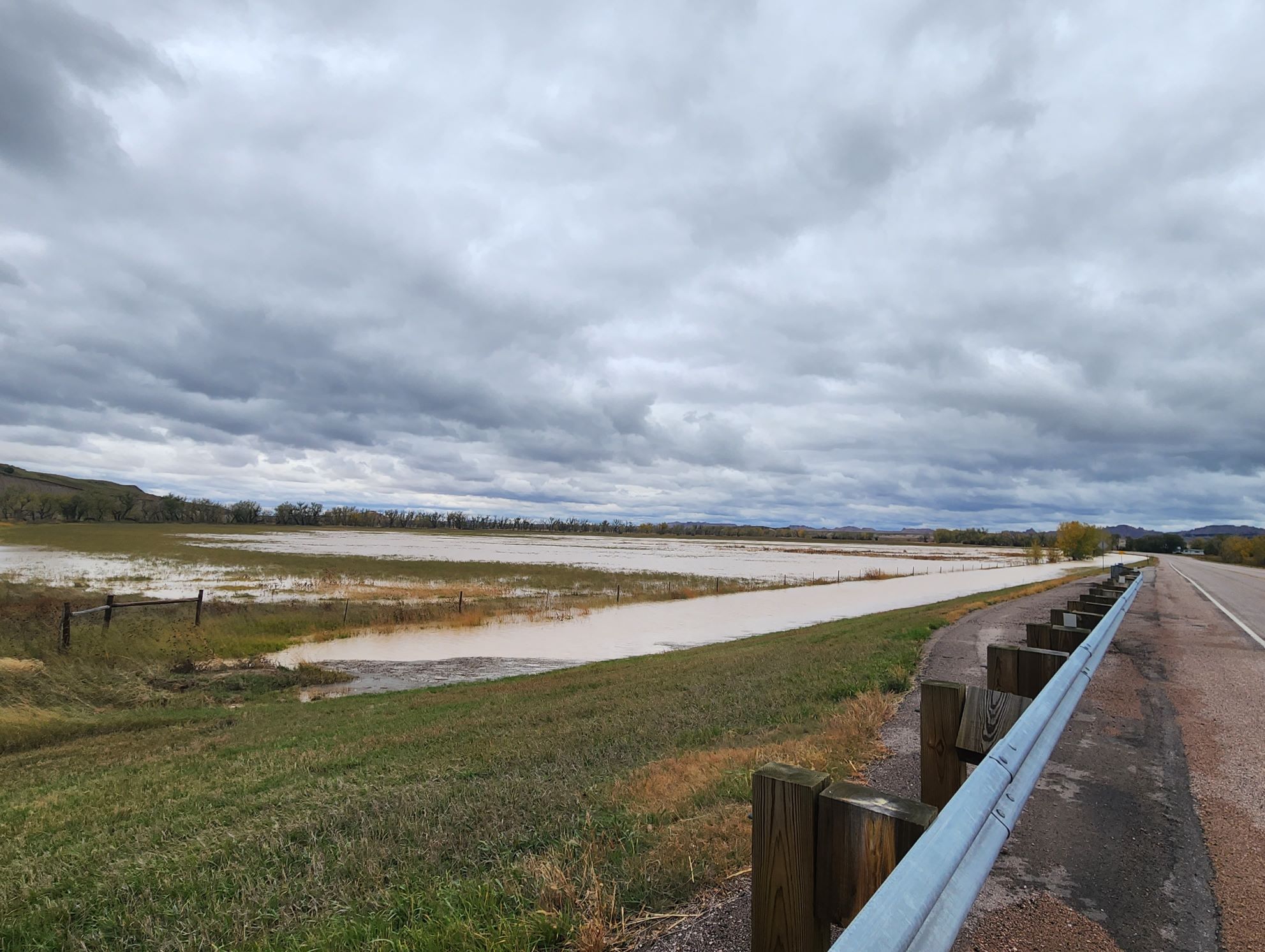 |
| White River near Interior | White River near Interior | White River near Interior | White River near Interior |
Rain Reports (Thursday morning through Friday noon)
*********STORM TOTAL RAINFALL (AT LEAST 1.00 INCH)**********

LOCATION                TOTAL      TIME/DATE  COMMENTS
                     RAINFALL       MEASURED
                     (inches)

SOUTH DAKOTA

...Bennett County...
  8 E Martin             2.75   700 AM 10/13  Co-Op Observer
  Martin                 1.68   345 PM 10/12  Public

...Custer County...
  1 SW Hermosa           4.28   754 AM 10/13  Trained Spotter
  Hermosa                4.14   600 AM 10/13  CoCoRaHS
  7 WSW Fairburn         3.67   700 AM 10/13  CoCoRaHS
  1 NW Hermosa           3.60   700 AM 10/13  CoCoRaHS
  6 W Hermosa            3.48   700 AM 10/13  CoCoRaHS
  7 WSW Folsom           3.33   500 AM 10/13  CoCoRaHS
  12 ENE Buffalo Gap     3.20   835 AM 10/13  Trained Spotter
  5 ENE Custer           3.11   700 AM 10/13  CoCoRaHS
  5 WNW Hermosa          3.08   917 PM 10/12  Trained Spotter
  1 ENE Custer           2.44   700 AM 10/13  CoCoRaHS

...Fall River County...
  Oral                   3.29   700 AM 10/13  Co-Op Observer
  2 SSW Ardmore          3.15   700 AM 10/13  CoCoRaHS
  Hot Springs            3.04   700 AM 10/13  CoCoRaHS
  1 S Hot Springs        2.26   800 AM 10/13  CoCoRaHS
  2 ENE Edgemont         2.00   700 AM 10/13  CoCoRaHS
  Angostura Res          1.32   700 AM 10/12  Trained Spotter
  14 NW Edgemont         1.23   800 AM 10/13  CoCoRaHS
  1 NNE Edgemont         1.20   700 AM 10/13  Co-Op Observer

...Haakon County...
  3 E Midland            2.68   700 AM 10/13  CoCoRaHS
  3 SE Philip            2.67   644 AM 10/13  CoCoRaHS
  9 SE Kirley            1.25   800 AM 10/13  CoCoRaHS

...Jackson County...
  3 WNW Kadoka           2.53   500 AM 10/13  CoCoRaHS
  3 WSW Wanblee          1.34   700 AM 10/12  CoCoRaHS

...Lawrence County...
  3 ESE Cheyenne Cross   1.67   700 AM 10/13  CoCoRaHS
  Lead                   1.40   900 AM 10/13  Co-Op Observer
  2 NW Central City      1.08   729 AM 10/13  CoCoRaHS

...Meade County...
  1 NNW Piedmont         2.96   728 PM 10/12  NWS Employee
  5 W Ellsworth AFB      1.99   700 AM 10/13  CoCoRaHS
  4 NNE Summerset        1.86   550 AM 10/13  CoCoRaHS
  Piedmont               1.86   700 AM 10/13  CoCoRaHS
  Tilford                1.76   700 AM 10/13  CoCoRaHS
  6 NE Summerset         1.56   700 AM 10/13  CoCoRaHS
  7 NNE Ellsworth AFB    1.24   700 AM 10/13  NWS Employee
  2 E Sturgis            1.19   700 PM 10/12  Co-Op Observer

...Mellette County...
  5 ESE Norris           5.10  1021 AM 10/13  Trained Spotter
  9 N Cedar Butte        4.78   600 AM 10/13  CoCoRaHS
  4 NE Wood              4.37   700 AM 10/13  CoCoRaHS
  3 NE Norris            3.95   500 AM 10/13  CoCoRaHS
  7 N Wood               3.83   600 AM 10/13  CoCoRaHS
  2 SSW Norris           3.06   700 AM 10/13  CoCoRaHS
  12 NNW White River     2.82   700 AM 10/13  CoCoRaHS

...Oglala Lakota County...
  3 ENE Kyle             3.06   700 AM 10/13  Co-Op Observer

...Pennington County...
  9 ENE Hayward          3.32   800 AM 10/13  CoCoRaHS
  3 NE Hisega            3.06   700 AM 10/13  CoCoRaHS
  4 W Dwtn Rapid City    2.99   700 AM 10/13  CoCoRaHS
  1 N Hisega             2.99   700 AM 10/13  NWS Employee
  4 NNE Johnson Siding   2.96   800 AM 10/13  CoCoRaHS
  12 S Quinn             2.94   800 AM 10/13  CoCoRaHS
  2 WNW Dwtn Rapid Cit   2.90   700 AM 10/13  CoCoRaHS
  3 NNE Johnson Siding   2.85   700 AM 10/13  CoCoRaHS
  2 SW Dwtn Rapid City   2.78   626 PM 10/12  NWS Employee
  4 NW Dwtn Rapid City   2.75   700 AM 10/13  Co-Op Observer
  1 ESE Pactola Resv     2.75   900 AM 10/13  Co-Op Observer
  1 N Johnson Siding     2.73   800 AM 10/13  CoCoRaHS
  2 SSE Dwtn Rapid Cit   2.72   700 AM 10/13  CoCoRaHS
  Hill City              2.70   928 AM 10/13  NWS Employee
  Mount Rushmore         2.67  1258 AM 10/13  Co-Op Observer
  1 NE Dwtn Rapid City   2.65   600 AM 10/13  CoCoRaHS
  1 E Dwtn Rapid City    2.63   600 PM 10/12  Official NWS Obs
  2 S Pactola Resv       2.60   600 AM 10/13  CoCoRaHS
  4 WNW Dwtn Rapid Cit   2.54   700 AM 10/13  CoCoRaHS
  4 S Dwtn Rapid City    2.42   700 AM 10/13  NWS Employee
  3 S Mystic             2.40   723 PM 10/12  Trained Spotter
  4 WNW Rapid City Arp   2.31   700 AM 10/13  CoCoRaHS
  3 W Scenic             2.17   700 AM 10/13  CoCoRaHS
  2 SE Dwtn Rapid City   1.80   900 AM 10/12  Public
  Wall                   1.76   800 AM 10/13  CoCoRaHS
  2 ENE Wall             1.67   700 AM 10/13  CoCoRaHS
  6 W New Underwood      1.64   700 AM 10/13  CoCoRaHS
  1 SSW Box Elder        1.62   700 AM 10/13  CoCoRaHS
  4 N Johnson Siding     1.50   922 AM 10/12  Trained Spotter
  3 SE Rapid Valley      1.25   800 AM 10/12  Public
  4 S New Underwood      1.10   900 AM 10/12  CoCoRaHS

...Todd County...
  4 NW Parmelee          4.52   700 AM 10/13  CoCoRaHS
  14 S Mission           3.69   700 AM 10/13  Co-Op Observer
  16 SSE Mission         2.96   600 AM 10/13  CoCoRaHS

...Tripp County...
  2 W Clearfield         4.61   802 AM 10/13  Public
  9 N Wewela             4.50   700 AM 10/13  CoCoRaHS
  1 NE Ideal             3.93   600 AM 10/13  CoCoRaHS
  6 N Hamill             3.87   600 AM 10/13  CoCoRaHS
  9 ENE Wewela           3.73   600 AM 10/13  CoCoRaHS
  2 SSE Ideal            3.60   600 AM 10/13  CoCoRaHS

WYOMING

...Campbell County...
  Wright                 1.84   700 AM 10/13  CoCoRaHS
  5 SSE Dwtn Gillette    1.53   700 AM 10/13  CoCoRaHS
  4 SE Gillette          1.46   530 PM 10/12  Co-Op Observer
  14 NNW Dwtn Gillette   1.11   700 AM 10/12  CoCoRaHS
  3 S Dwtn Gillette      1.11   700 AM 10/12  CoCoRaHS

...Weston County...
  1 WNW Clareton         2.04   700 AM 10/12  CoCoRaHS
  5 SW Upton             1.06   700 AM 10/13  CoCoRaHS


...PRELIMINARY RAINFALL TOTALS (AT LEAST 1.00 INCH) SORTED BY MAGNITUDE...

LOCATION                      TOTAL RAIN  COMMENTS
                               IN/S/

5 ESE Norris SD                5.10       1021 AM 10/13/2023
9 N Cedar Butte SD             4.78        600 AM 10/13/2023
2 W Clearfield SD              4.61        802 AM 10/13/2023
4 NW Parmelee SD               4.52        700 AM 10/13/2023
9 N Wewela SD                  4.50        700 AM 10/13/2023
4 NE Wood SD                   4.37        700 AM 10/13/2023
1 SW Hermosa SD                4.28        754 AM 10/13/2023
Hermosa SD                     4.14        600 AM 10/13/2023
3 NE Norris SD                 3.95        500 AM 10/13/2023
1 NE Ideal SD                  3.93        600 AM 10/13/2023
6 N Hamill SD                  3.87        600 AM 10/13/2023
7 N Wood SD                    3.83        600 AM 10/13/2023
9 ENE Wewela SD                3.73        600 AM 10/13/2023
14 S Mission SD                3.69        700 AM 10/13/2023
7 WSW Fairburn SD              3.67        700 AM 10/13/2023
2 SSE Ideal SD                 3.60        600 AM 10/13/2023
1 NW Hermosa SD                3.60        700 AM 10/13/2023
6 W Hermosa SD                 3.48        700 AM 10/13/2023
7 WSW Folsom SD                3.33        500 AM 10/13/2023
9 ENE Hayward SD               3.32        800 AM 10/13/2023
Oral SD                        3.29        700 AM 10/13/2023
12 ENE Buffalo Gap SD          3.20        835 AM 10/13/2023
2 SSW Ardmore SD               3.15        700 AM 10/13/2023
5 ENE Custer SD                3.11        700 AM 10/13/2023
5 WNW Hermosa SD               3.08        917 PM 10/12/2023
3 NE Hisega SD                 3.06        700 AM 10/13/2023
3 ENE Kyle SD                  3.06        700 AM 10/13/2023
2 SSW Norris SD                3.06        700 AM 10/13/2023
Hot Springs SD                 3.04        700 AM 10/13/2023
4 W Dwtn Rapid City SD         2.99        700 AM 10/13/2023
1 N Hisega SD                  2.99        700 AM 10/13/2023
1 NNW Piedmont SD              2.96        728 PM 10/12/2023
4 NNE Johnson Siding SD        2.96        800 AM 10/13/2023
16 SSE Mission SD              2.96        600 AM 10/13/2023
12 S Quinn SD                  2.94        800 AM 10/13/2023
2 WNW Dwtn Rapid City SD       2.90        700 AM 10/13/2023
3 NNE Johnson Siding SD        2.85        700 AM 10/13/2023
12 NNW White River SD          2.82        700 AM 10/13/2023
2 SW Dwtn Rapid City SD        2.78        626 PM 10/12/2023
4 NW Dwtn Rapid City SD        2.75        700 AM 10/13/2023
8 E Martin SD                  2.75        700 AM 10/13/2023
1 ESE Pactola Resv SD          2.75        900 AM 10/13/2023
1 N Johnson Siding SD          2.73        800 AM 10/13/2023
2 SSE Dwtn Rapid City SD       2.72        700 AM 10/13/2023
Hill City SD                   2.70        928 AM 10/13/2023
3 E Midland SD                 2.68        700 AM 10/13/2023
Mount Rushmore SD              2.67       1258 AM 10/13/2023
3 SE Philip SD                 2.67        644 AM 10/13/2023
1 NE Dwtn Rapid City SD        2.65        600 AM 10/13/2023
1 E Dwtn Rapid City SD         2.63        600 PM 10/12/2023
2 S Pactola Resv SD            2.60        600 AM 10/13/2023
4 WNW Dwtn Rapid City SD       2.54        700 AM 10/13/2023
3 WNW Kadoka SD                2.53        500 AM 10/13/2023
1 ENE Custer SD                2.44        700 AM 10/13/2023
4 S Dwtn Rapid City SD         2.42        700 AM 10/13/2023
3 S Mystic SD                  2.40        723 PM 10/12/2023
4 WNW Rapid City Arpt SD       2.31        700 AM 10/13/2023
1 S Hot Springs SD             2.26        800 AM 10/13/2023
3 W Scenic SD                  2.17        700 AM 10/13/2023
1 WNW Clareton WY              2.04        700 AM 10/12/2023
2 ENE Edgemont SD              2.00        700 AM 10/13/2023
5 W Ellsworth AFB SD           1.99        700 AM 10/13/2023
4 NNE Summerset SD             1.86        550 AM 10/13/2023
Piedmont SD                    1.86        700 AM 10/13/2023
Wright WY                      1.84        700 AM 10/13/2023
2 SE Dwtn Rapid City SD        1.80        900 AM 10/12/2023
Wall SD                        1.76        800 AM 10/13/2023
Tilford SD                     1.76        700 AM 10/13/2023
Martin SD                      1.68        345 PM 10/12/2023
3 ESE Cheyenne Crossing SD     1.67        700 AM 10/13/2023
2 ENE Wall SD                  1.67        700 AM 10/13/2023
6 W New Underwood SD           1.64        700 AM 10/13/2023
1 SSW Box Elder SD             1.62        700 AM 10/13/2023
6 NE Summerset SD              1.56        700 AM 10/13/2023
5 SSE Dwtn Gillette WY         1.53        700 AM 10/13/2023
4 N Johnson Siding SD          1.50        922 AM 10/12/2023
4 SE Gillette WY               1.46        530 PM 10/12/2023
Lead SD                        1.40        900 AM 10/13/2023
3 WSW Wanblee SD               1.34        700 AM 10/12/2023
Angostura Res SD               1.32        700 AM 10/12/2023
3 SE Rapid Valley SD           1.25        800 AM 10/12/2023
9 SE Kirley SD                 1.25        800 AM 10/13/2023
7 NNE Ellsworth AFB SD         1.24        700 AM 10/13/2023
14 NW Edgemont SD              1.23        800 AM 10/13/2023
1 NNE Edgemont SD              1.20        700 AM 10/13/2023
2 E Sturgis SD                 1.19        700 PM 10/12/2023
14 NNW Dwtn Gillette WY        1.11        700 AM 10/12/2023
3 S Dwtn Gillette WY           1.11        700 AM 10/12/2023
4 S New Underwood SD           1.10        900 AM 10/12/2023
2 NW Central City SD           1.08        729 AM 10/13/2023
5 SW Upton WY                  1.06        700 AM 10/13/2023
 |
Media use of NWS Web News Stories is encouraged! Please acknowledge the NWS as the source of any news information accessed from this site. |
|

