
Elevated to locally critical fire weather conditions will continue across portions of the Southern Plains and Southeast today due to gusty winds and low humidity. Widely scattered strong to severe storms may impact southern Texas through the Southeast and the central Appalachians and southern Mid-Atlantic. Read More >
Overview
|
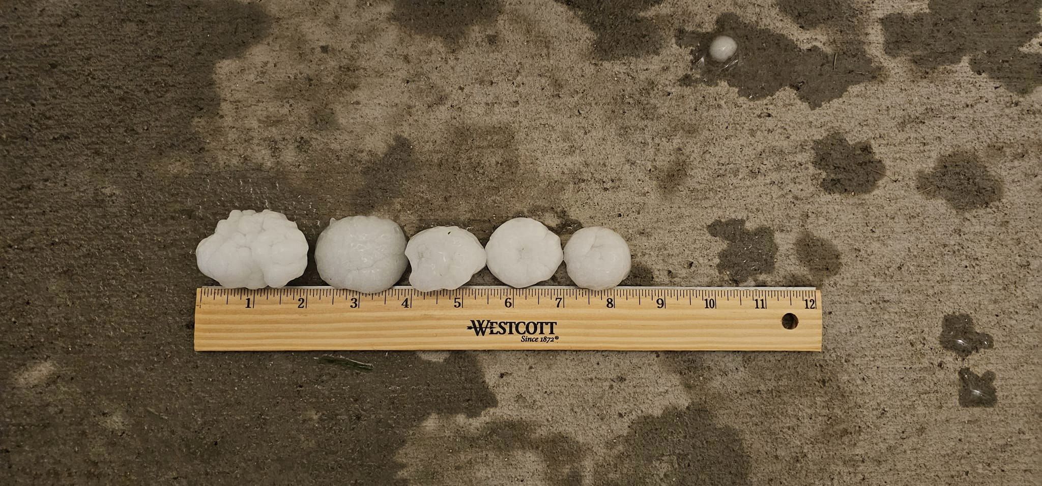
Severe storms with large hail and damaging winds occurred on July 11, 2023 over parts of northeastern Wyoming and western South Dakota. A swath of large hail, up to baseball size, moved through northern Campbell and Crook Counties, causing major damage to structures and vehicles. Other areas of northeastern Wyoming, the Black Hills, and the western South Dakota plains were hit with tennis ball sized hail. Along with the destructive hail, several strong and damaging wind reports occurred as the severe thunderstorms moved across the region. This highest wind gust reported was 71 MPH near Ludlow, SD. As can be seen in the lightning map to the right (click to enlarge), thunderstorms occurred across a large portion of northeast Wyoming, western South Dakota and south-central South Dakota. Positive cloud-to-ground flashes were especially notable from northern Campbell county through the Black Hills, and from northwestern South Dakota through south central South Dakota, where areas of heavier rain and larger hail occurred. |
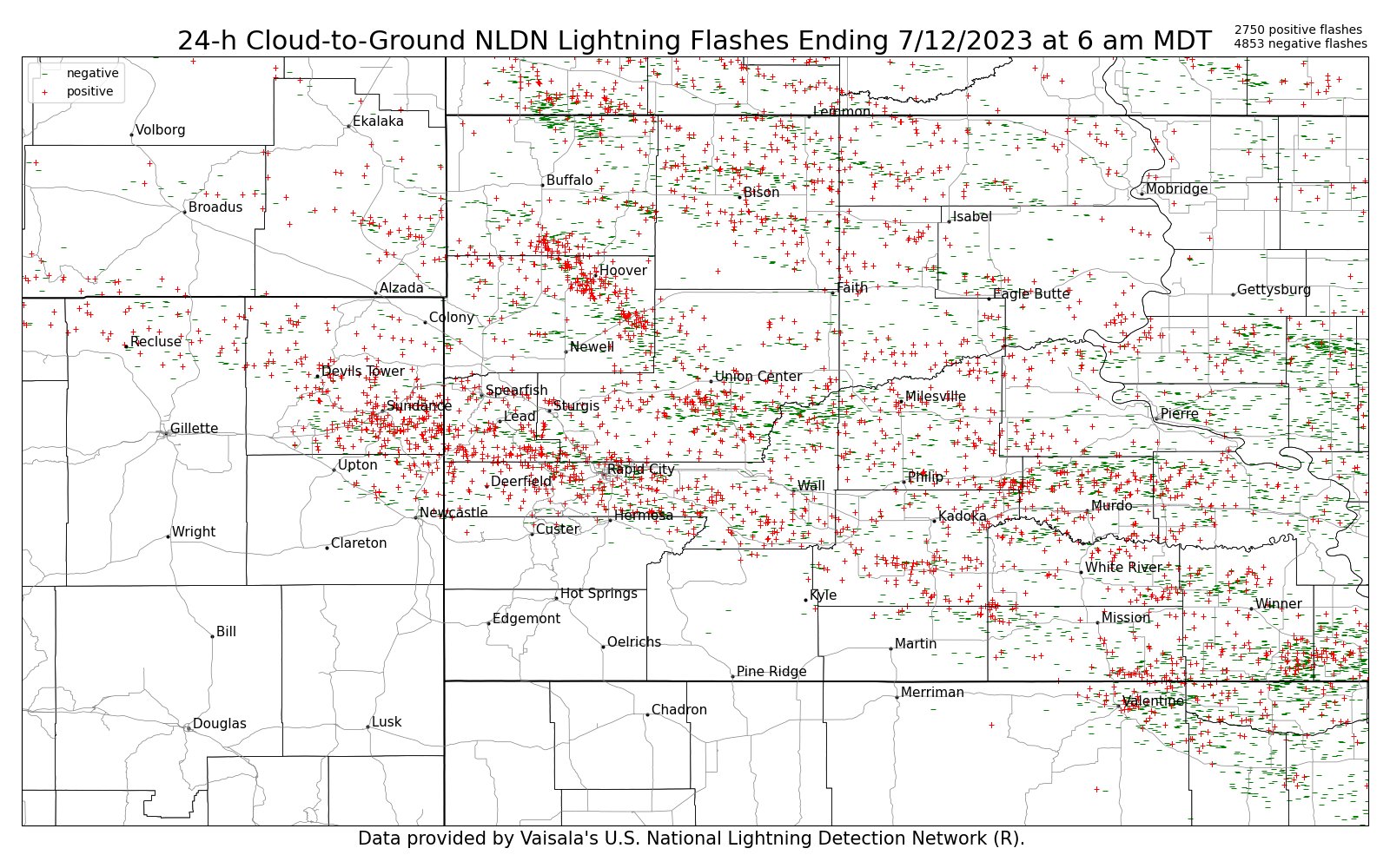
Here is the 24-hour cloud-to-ground lightning map from 6 am MDT Tuesday (7/11) to 6 am MDT Wednesday (7/12). Red plus signs indicate positive polarity flashes and green dashes indicate negative polarity flashes. Total flash counts in upper right. |
Photos
 |
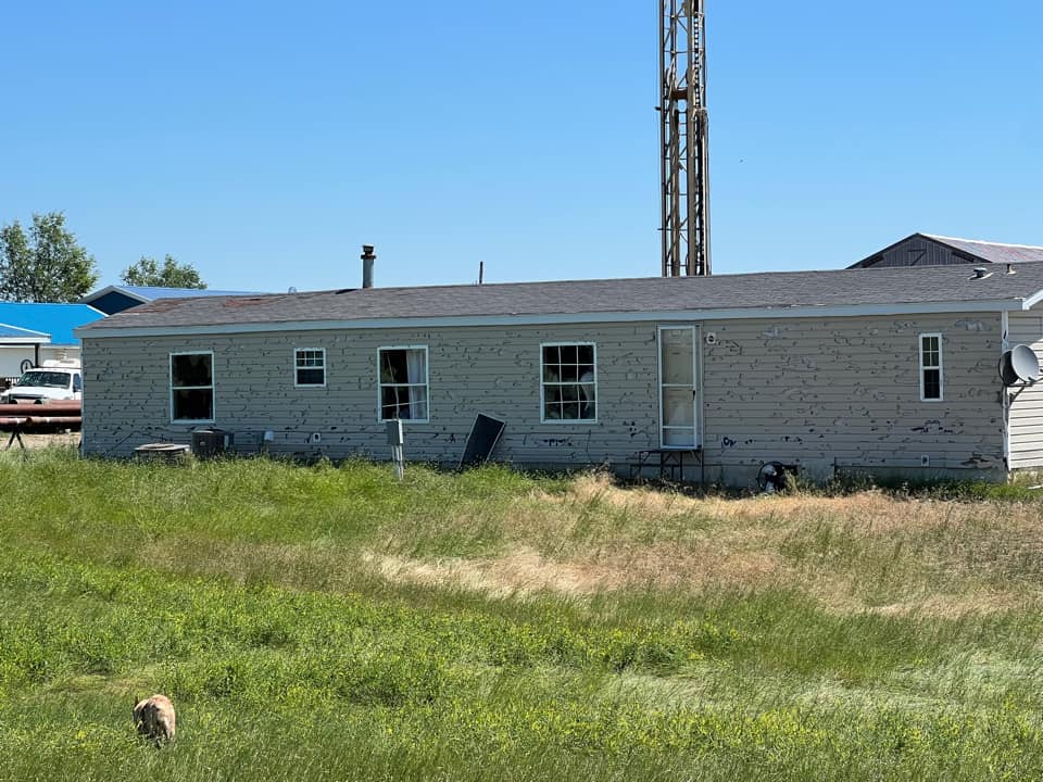 |
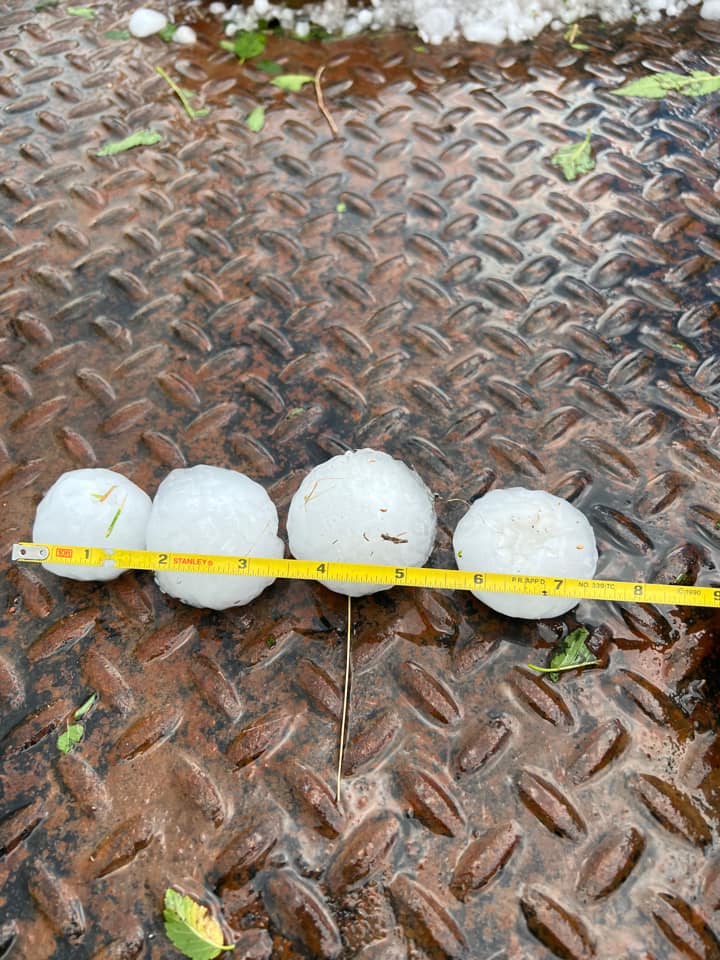
| Hail and home damage from hail near Spotted Horse WY (credit: Chris Odegard) |
|
 |
 |
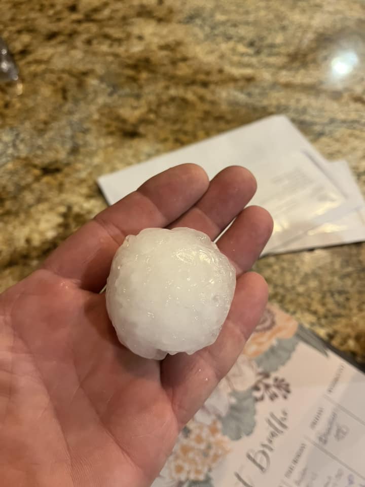
| Hail at Red Rocks Rapid City (credit: Cheryl O'Malley) |
Hail near Osage WY (credit: Lindsey Garhart) |
 |
 |
| Hail at Sheridan Lake Rd, Rapid City (Credit: Ben Nelson) |
Hail near Catron/Highway 16, Rapid City (Credit: Jon Chamberlain) |
Radar and Satellite
Radar loop from 350 PM to 950 PM MDT on July 11, 2023
Radar loop from 950 PM on July 11, 2023 to 350 AM MDT July 12, 2023
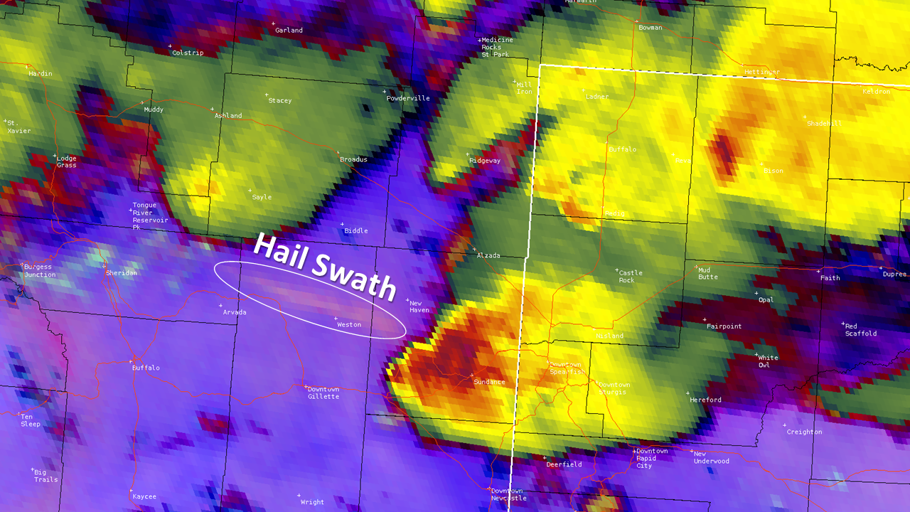
Satellite image showing a hail swath across northeast Wyoming
Storm Reports
Here are a list of storm reports collected during the event.
**************PEAK WIND GUST (AT LEAST 50 MPH)**************

LOCATION             MAX WIND      TIME/DATE  COMMENTS
                         GUST       MEASURED
                        (mph)

SOUTH DAKOTA

...Bennett County...
  1 ESE Martin             54  1215 AM  7/12  AWOS

...Butte County...
  7 WSW Hoover             58   621 PM  7/11  SDDOT

...Haakon County...
  1 NE Midland             54  1200 AM  7/12  SDDOT

...Harding County...
  4 N Ludlow               71   756 PM  7/11  SDDOT
  Reva                     60   830 PM  7/11  Trained Spotter
  7 NNE Ralph              60   806 PM  7/11  SDDOT

...Oglala Lakota County...
  5 NE Porcupine           52  1241 AM  7/12  RAWS

...Pennington County...
  1 WNW Caputa             53   605 PM  7/11  SDSU Mesonet

...Todd County...
  15 SSE Mission           64   112 AM  7/12  SDDOT
  6 W Parmelee             51  1228 AM  7/12  RAWS
  7 ESE Rosebud            51   105 AM  7/12  SDSU Mesonet

...Tripp County...
  Wewela                   69   157 AM  7/12  SDDOT
  1 NE Winner              54   131 AM  7/12  ASOS

WYOMING

...Campbell County...
  1 NNE Recluse            60   708 PM  7/11  Trained Spotter
  2 ENE Weston             53   738 PM  7/11  Trained Spotter

...Crook County...
  Devils Tower             60   815 PM  7/11  Public
  11 N Hulett              60  1045 PM  7/11  Public


***********MAXIMUM HAIL SIZE (AT LEAST 0.50 MPH)************

LOCATION                 HAIL      TIME/DATE  COMMENTS
                         SIZE       MEASURED
                     (inches)

SOUTH DAKOTA

...Butte County...
  6 W Hoover             1.25   614 PM  7/11  Public
  14 ESE Castle Rock     1.00   648 PM  7/11  Public

...Harding County...
  1 S Ludlow             1.75   933 PM  7/11  Mping
  4 E Ludlow             1.75   945 PM  7/11  Public
  8 SSE Ralph            1.50   818 PM  7/11  Trained Spotter
  8 W Harding            1.25   830 PM  7/11  Public
  7 N Ludlow             1.00   740 PM  7/11  Public
  6 S Reva               1.00   245 PM  7/11  Public

...Lawrence County...
  1 S Dwtn Spearfish     1.00   914 PM  7/11  mPING report
  Dwtn Spearfish         0.88   909 PM  7/11  Facebook

...Meade County...
  8 NNE Hereford         1.50   759 PM  7/11  Facebook

...Pennington County...
  4 S Dwtn Rapid City    2.00  1023 PM  7/11  NWS Employee
  5 NE Rockerville       1.75  1019 PM  7/11  mPING report
  Pactola Resv           1.75  1000 PM  7/11  Public
  4 SSW Dwtn Rapid Cit   1.75  1025 PM  7/11  Trained Spotter
  4 WSW Dwtn Rapid Cit   1.50  1025 PM  7/11  Trained Spotter
  4 SW Dwtn Rapid City   1.50  1024 PM  7/11  mPING report
  Box Elder              1.50   456 PM  7/11  Twitter
  2 WSW Rockerville      1.50  1034 PM  7/11  Facebook
  5 SW Dwtn Rapid City   1.50  1020 PM  7/11  NWS Employee
  Caputa                 1.00   615 PM  7/11  Public
  2 NNE Johnson Siding   1.00   548 PM  7/11  Facebook
  5 WNW Hermosa          1.00  1100 PM  7/11  Public
  Hisega                 1.00  1010 PM  7/11  Public
  1 S Dwtn Rapid City    1.00  1022 PM  7/11  Trained Spotter
  3 SW Dwtn Rapid City   1.00  1020 PM  7/11  mPING report
  Hill City              0.88  1231 AM  7/12  NWS Employee
  Rapid City Arpt        0.88   555 PM  7/11  ASOS
  4 WSW Rochford         0.75  1005 PM  7/11  mPING report
  2 SSE Dwtn Rapid Cit   0.75  1032 PM  7/11  mPING report

...Perkins County...
  11 SSW Bison           1.00   910 PM  7/11  Trained Spotter

WYOMING

...Campbell County...
  1 NNE Recluse          2.50   708 PM  7/11  Trained Spotter
  18 NNE Recluse         1.00   953 PM  7/11  Public

...Crook County...
  Devils Tower           2.00   815 PM  7/11  Public
  9 SSE Devils Tower     1.50   827 PM  7/11  Facebook
  4 ESE Pine Haven       1.50   900 PM  7/11  Trained Spotter
  Sundance               1.25   841 PM  7/11  Trained Spotter
  2 NW Oshoto            1.00   759 PM  7/11  Public
  11 N Hulett            1.00  1045 PM  7/11  Public

...Weston County...
  SE Osage               2.50  1135 PM  7/11  Facebook


...MAXIMUM OBSERVED WINDS (AT LEAST 50 MPH) SORTED BY MAGNITUDE...

LOCATION                      MAX WIND    COMMENTS
                               MPH

4 N Ludlow SD                    71        756 PM 7/11/2023
Wewela SD                        69        157 AM 7/12/2023
15 SSE Mission SD                64        112 AM 7/12/2023
Reva SD                          60        830 PM 7/11/2023
Devils Tower WY                  60        815 PM 7/11/2023
7 NNE Ralph SD                   60        806 PM 7/11/2023
11 N Hulett WY                   60       1045 PM 7/11/2023
1 NNE Recluse WY                 60        708 PM 7/11/2023
7 WSW Hoover SD                  58        621 PM 7/11/2023
1 ESE Martin SD                  54       1215 AM 7/12/2023
1 NE Winner SD                   54        131 AM 7/12/2023
1 NE Midland SD                  54       1200 AM 7/12/2023
2 ENE Weston WY                  53        738 PM 7/11/2023
1 WNW Caputa SD                  53        605 PM 7/11/2023
5 NE Porcupine SD                52       1241 AM 7/12/2023
6 W Parmelee SD                  51       1228 AM 7/12/2023
7 ESE Rosebud SD                 51        105 AM 7/12/2023


...MAXIMUM HAIL SIZE (AT LEAST 0.50 INCH) SORTED BY MAGNITUDE...

LOCATION                      MAX SIZE    COMMENTS
                               IN/S/

1 NNE Recluse WY               2.50        708 PM 7/11/2023
Osage WY                       2.50       1135 PM 7/11/2023
Devils Tower WY                2.00        815 PM 7/11/2023
4 S Dwtn Rapid City SD         2.00       1023 PM 7/11/2023
5 NE Rockerville SD            1.75       1019 PM 7/11/2023
Pactola Resv SD                1.75       1000 PM 7/11/2023
1 S Ludlow SD                  1.75        933 PM 7/11/2023
4 E Ludlow SD                  1.75        945 PM 7/11/2023
4 SSW Dwtn Rapid City SD       1.75       1025 PM 7/11/2023
9 SSE Devils Tower WY          1.50        827 PM 7/11/2023
4 WSW Dwtn Rapid City SD       1.50       1025 PM 7/11/2023
4 SW Dwtn Rapid City SD        1.50       1024 PM 7/11/2023
8 NNE Hereford SD              1.50        759 PM 7/11/2023
Box Elder SD                   1.50        456 PM 7/11/2023
2 WSW Rockerville SD           1.50       1034 PM 7/11/2023
4 ESE Pine Haven WY            1.50        900 PM 7/11/2023
5 SW Dwtn Rapid City SD        1.50       1020 PM 7/11/2023
8 SSE Ralph SD                 1.50        818 PM 7/11/2023
6 W Hoover SD                  1.25        614 PM 7/11/2023
8 W Harding SD                 1.25        830 PM 7/11/2023
Sundance WY                    1.25        841 PM 7/11/2023
14 ESE Castle Rock SD          1.00        648 PM 7/11/2023
18 NNE Recluse WY              1.00        953 PM 7/11/2023
11 SSW Bison SD                1.00        910 PM 7/11/2023
Caputa SD                      1.00        615 PM 7/11/2023
1 S Dwtn Spearfish SD          1.00        914 PM 7/11/2023
2 NNE Johnson Siding SD        1.00        548 PM 7/11/2023
SE Osage WY                    1.00       1135 PM 7/11/2023
5 WNW Hermosa SD               1.00       1100 PM 7/11/2023
Hisega SD                      1.00       1010 PM 7/11/2023
7 N Ludlow SD                  1.00        740 PM 7/11/2023
2 NW Oshoto WY                 1.00        759 PM 7/11/2023
1 S Dwtn Rapid City SD         1.00       1022 PM 7/11/2023
3 SW Dwtn Rapid City SD        1.00       1020 PM 7/11/2023
6 S Reva SD                    1.00        245 PM 7/11/2023
11 N Hulett WY                 1.00       1045 PM 7/11/2023
Dwtn Spearfish SD              0.88        909 PM 7/11/2023
Hill City SD                   0.88       1231 AM 7/12/2023
Rapid City Arpt SD             0.88        555 PM 7/11/2023
4 WSW Rochford SD              0.75       1005 PM 7/11/2023
2 SSE Dwtn Rapid City SD       0.75       1032 PM 7/11/2023
 |
Media use of NWS Web News Stories is encouraged! Please acknowledge the NWS as the source of any news information accessed from this site. |
|

