
A heat wave over the Southwest will intensify this week, peaking and expanding into the Intermountain West and northern High Plains this weekend. Critical to extremely critical fire weather conditions are forecast from the Northwest and the northern Great Basin this weekend. Particularly Dangerous Situation Red Flag Warnings have been issued. Read More >
Overview
|
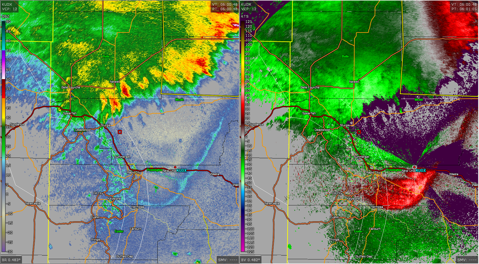
Severe thunderstorms with large hail and strong winds moved across northeastern Wyoming and western South Dakota Wednesday evening (June 26, 2019). By late evening, the storms began to move rapidly to the northeast around 40 mph across northwestern South Dakota, producing damaging winds and causing power outages. As the main part of the rain was concentrated over northwestern South Dakota, an outflow boundary from the storms moved rapidly to the south. As the boundary approached the Black Hills, the winds rapidly increased from the north and northwest. Wind gusts of 55 mph to 65 mph were reported shortly before midnight across the foothills and plains on the eastern side of the Black Hills around Rapid City. It is fairly unusual to get winds this strong this far ahead of thunderstorms. A heat burst also occurred across south-central South Dakota. |
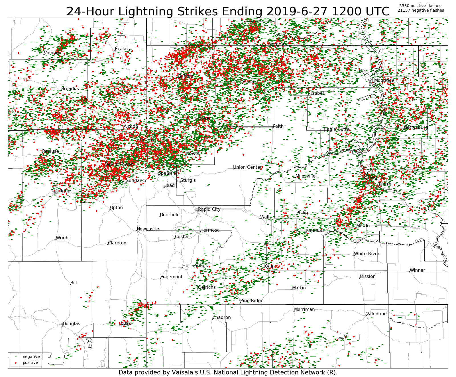
Radar & Lightning
Radar animation from 7:45 pm MDT to 1:03 am MDT (KUDX)
 |
 |
|
| Radar reflectivity (R) and velocity (L) at midnight showing outflow that produced 55-65 mph gusts along the eastern slopes of the Black Hills. |
|
Storm Reports
Here are the preliminary severe thunderstorm storm reports for June 26, 2019.
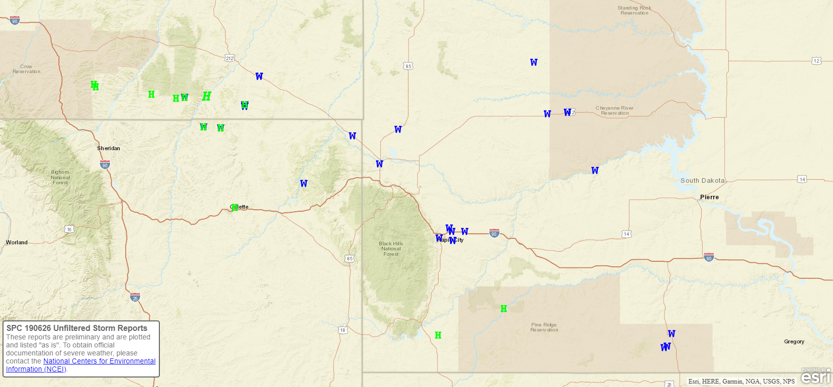 |
| Preliminary storm reports for June 26, 2019 (green H's represent hail; blue W's represent wind gusts) |
The storm reports listed below are in descending order and may not
necessarily be the final storm reports.

Hail reports listed by size (inches)

 SIZE    LOCATION                 ST  COUNTY           TIME
 ------  -----------------------  --  --------------   -------
  1.75   14 NNE RECLUSE           WY  CAMPBELL         0820 PM
  1.25   3 ENE DOWNTOWN GILLETTE  WY  CAMPBELL         0930 PM
  1.00   1 N ROCKYFORD            SD  OGLALA LAKOTA    0850 PM
  1.00   SMITHWICK                SD  FALL RIVER       0807 PM
  1.00   15 NNW RECLUSE           WY  CAMPBELL         0755 PM
  0.88   QUINN                    SD  PENNINGTON       0950 PM
  0.75   4 NW DOWNTOWN BELLE FOU  SD  BUTTE            1024 PM
  0.70   8 NW ROCKYPOINT          WY  CAMPBELL         0854 PM
  0.70   11 SSE WESTON            WY  CAMPBELL         0847 PM
  0.50   1 SSW DOWNTOWN BELLE FO  SD  BUTTE            1045 PM


Tstm wind reports listed by speed (mph)

 SPEED   LOCATION                 ST  COUNTY           TIME
 ------  -----------------------  --  --------------   -------
 70.00   HOOVER                   SD  BUTTE            1106 PM
 70.00   15 NNW RECLUSE           WY  CAMPBELL         0756 PM
 66.00   7 SSE MEADOW             SD  PERKINS          1224 AM
 65.00   6 ESE ROSEBUD            SD  TODD             1230 AM
                 HEAT BURST WITH A DECAYING THUNDERSTORM.
 64.00   BOX ELDER                SD  PENNINGTON       1155 PM
                 CONVECTIVE WIND GUSTS ALONG OUTFLOW BOUNDARY
                 30 MILES FROM THUNDERSTORMS.
 63.00   5 WNW NEW UNDERWOOD      SD  PENNINGTON       1155 PM
                 CONVECTIVE WIND GUSTS ALONG OUTFLOW BOUNDARY
                 30 MILES FROM THUNDERSTORMS.
 62.00   1 WSW RED ELM            SD  ZIEBACH          0118 AM
                 OCCURRED WITH DECAYING THUNDERSTORMS
 61.00   1 NNE FAITH              SD  MEADE            1256 AM
                 OCCURRED WITH DECAYING THUNDERSTORMS
 61.00   RAPID CITY AIRPORT       SD  PENNINGTON       1155 PM
                 CONVECTIVE WIND GUST ALONG OUTFLOW BOUNDARY
                 30 MILES FROM THUNDERSTORMS.
 61.00   ELLSWORTH AFB            SD  MEADE            1144 PM
                 CONVECTIVE WIND GUSTS ALONG OUTFLOW BOUNDARY
                 30 MILES FROM THUNDERSTORMS.
 60.00   7 SSW MISSION            SD  TODD             1233 AM
                 WIND GUST ASSOCIATED WITH A HEAT BURST WITH A
                 COLLAPSING THUNDERSTORM.
 60.00   CHERRY CREEK             SD  ZIEBACH          1223 AM
                 CONVECTIVE WIND GUST ALONG OUTFLOW BOUNDRY
                 FROM THUNDERSTORMS 30 MILES NORTH
 60.00   1 WSW RED ELM            SD  ZIEBACH          1219 AM
 60.00   RAPID CITY AIRPORT       SD  PENNINGTON       1146 PM
                 CONVECTIVE WIND GUSTS ALONG OUTFLOW BOUNDARY
                 30 MILES FROM THUNDERSTORMS.
 60.00   1 SSW DOWNTOWN BELLE FO  SD  BUTTE            1045 PM
 60.00   12 WSW CASTLE ROCK       SD  BUTTE            1045 PM
 60.00   COLONY                   WY  CROOK            1010 PM
 60.00   6 ENE CARLILE            WY  CROOK            0940 PM
 60.00   14 NNE RECLUSE           WY  CAMPBELL         0820 PM
 59.00   1 E DOWNTOWN RAPID CITY  SD  PENNINGTON       1147 PM
                 CONVECTIVE WIND GUSTS ALONG OUTFLOW BOUNDARY
                 30 MILES FROM THUNDERSTORMS.
 56.00   3 NW WASTA               SD  PENNINGTON       1229 AM
                 CONVECTIVE WIND GUST ON OUTFLOW BOUNDARY 30
                 MILES FROM THUNDERSTORMS.
 55.00   REDIG                    SD  HARDING          1119 PM
 54.00   3 W UNION CENTER         SD  MEADE            1200 AM
                 CONVECTIVE WIND GUSTS ALONG OUTFLOW BOUNDARY
                 5 TO 10 MILES FROM THUNDERSTORMS.
 53.00   SLIM BUTTES              SD  OGLALA LAKOTA    1114 PM
 52.00   3 SW OPAL                SD  MEADE            1158 PM
 51.00   1 N BUFFALO              SD  HARDING          1053 PM
 50.00   8 NW ROCKYPOINT          WY  CAMPBELL         0854 PM
 50.00   15 NNW RECLUSE           WY  CAMPBELL         0751 PM
 49.00   2 ENE WESTON             WY  CAMPBELL         0852 PM

Tstm wind damage reports

LOCATION                 ST  COUNTY           TIME
-----------------------  --  --------------   -------
8 WNW USTA               SD  PERKINS          1200 AM
                 ROOF TORN OFF BUILDINGS, HUGE TREES
                 SNAPPED AND SPLIT. TRAILER HOUSE
                 DAMAGED.
MISSION                  SD  TODD             1233 AM
                 TREES DOWN IN MISSION. APPEARS TO BE A
                 HEAT BURST WITH A COLLAPSING
                 THUNDERSTORM.
9 WSW RED ELM            SD  ZIEBACH          0100 AM
                 POWER POLE YARD LIGHT KNOCKED DOWN FROM
                 POST THUNDERSTORM OUTFLOW WIND. WIND
                 ESTIMATED 60 TO 80 MPH.

Rain amounts (inches)

 AMOUNT  LOCATION                 ST  COUNTY           TIME
 ------  -----------------------  --  --------------   -------
  1.84   1 SW SHADEHILL           SD  PERKINS          0644 AM
                 STORM TOTAL RAINFALL
  1.75   6 NW SHADEHILL RESERVOI  SD  PERKINS          0643 AM
                 STORM TOTAL RAINFALL
  1.50   8 WNW USTA               SD  PERKINS          1200 AM
                 ROOF TORN OFF BUILDINGS, HUGE TREES SNAPPED
                 AND SPLIT. TRAILER HOUSE DAMAGED.
  1.10   11 WNW DOWNTOWN BELLE F  SD  BUTTE            0647 AM
                 STORM TOTAL RAINFALL
  1.05   2 ENE WESTON             WY  CAMPBELL         0852 PM
  0.90   1 ESE DOWNTOWN BELLE FO  SD  BUTTE            0647 AM
                 STORM TOTAL RAINFALL
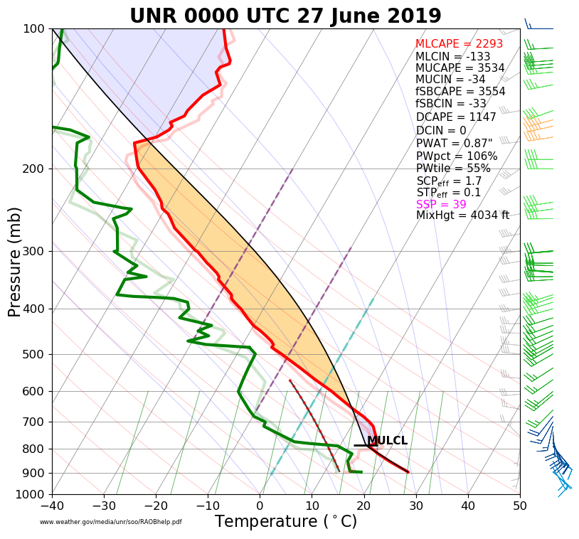
Environment
The near-storm environment was rather unstable (left image) and strongly sheared (right image) based upon the data gathered from the 6 pm MDT balloon launch.
 |
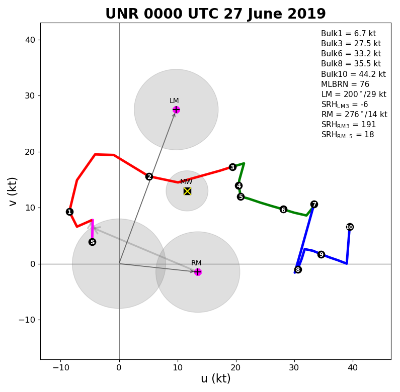 |
| Sounding based off the 6 pm balloon release at NWS Rapid City | Hodograph based off the 6 pm balloon release at NWS Rapid City |
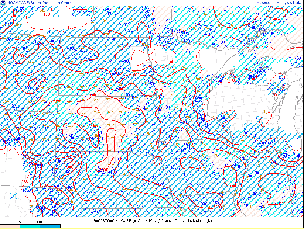
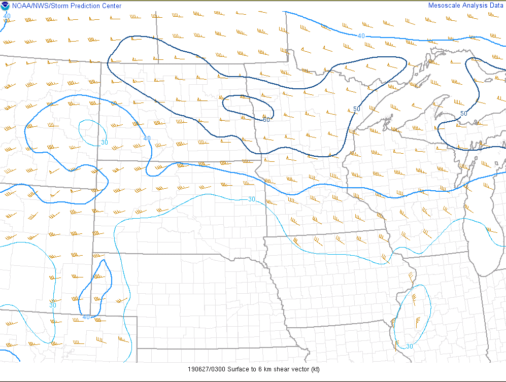
The mesoscale analysis from the Storm Prediction Center (SPC) showed modest buoyancy (left image) over northeastern Wyoming into northwestern South Dakota (strongest over central South Dakota). The vertical wind shear from the surface to about 18,000 feet above ground (middle image) was sufficient for rotating thunderstorms and subsequent severe weather across the area. While large hail was observed, especially early in the evening's evolution, the primary hazard was strong wind gusts. The atmosphere was primed for strong thunderstorm downdraft potential across much of northeastern Wyoming and western South Dakota (right image).
 |
 |
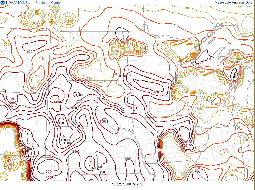 |
| Most-unstable CAPE (a measure of buoyancy in the atmosphere) valid at 9 pm MDT | 0-6 km wind difference (a measure of storm rotation potential) valid at 9 pm MDT | Downdraft CAPE (a measure of severe wind gust potential) valid at 9 pm MDT |
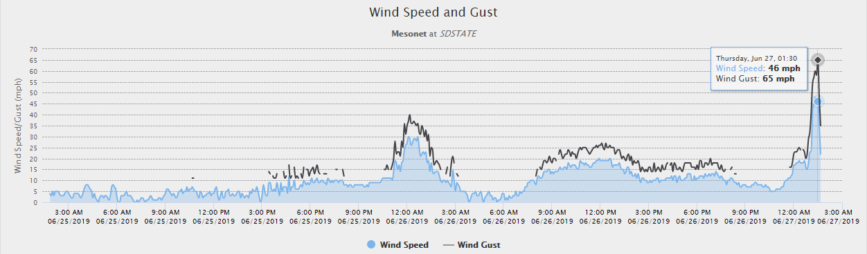
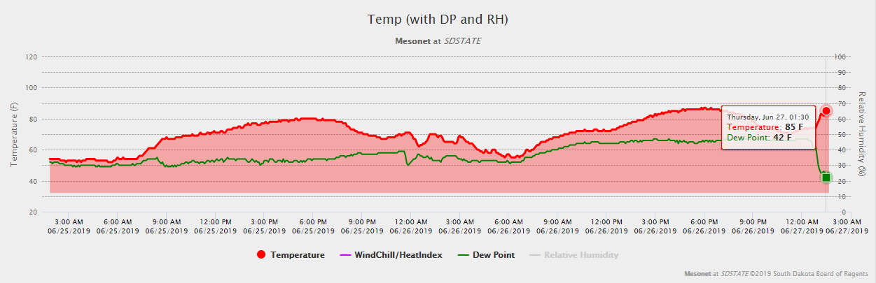
Heat Burst
 |
 |
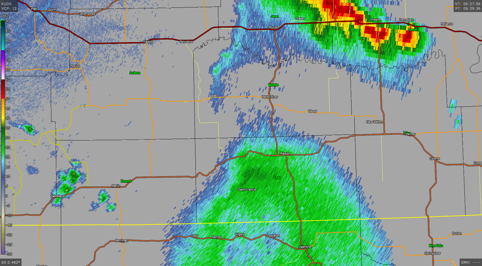 |
| Winds gusted to 65mph at Rosebud at 1:30am CDT (image courtesy of SDSU) | Temperature at Rosebud jumped from mid-70s to 85F while the dewpoint dropped to 42F (image courtesy of SDSU) | Radar reflectivity around 1:30am CDT shows collapsing thunderstorm near in Todd county. |
 |
Media use of NWS Web News Stories is encouraged! Please acknowledge the NWS as the source of any news information accessed from this site. |
|

