An unprecedented early-season blizzard with driving rain; heavy, wet snow; and strong winds struck the Black Hills region October 3-5, 2013; paralyzing much of the area for several days.


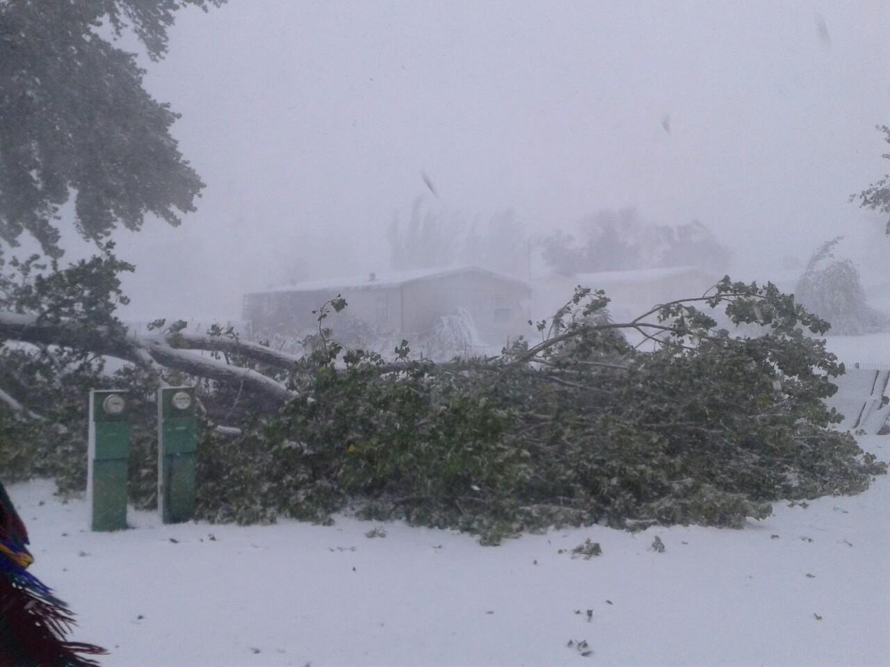
Tree debris at Fitzgerald Field in Rapid City. Photo by Pennington County Emergency Management Office.
On October 3, the intense moisture-laden storm moved from the Rockies onto the plains while unseasonably cold air pushed south from Canada. These air masses collided over the Black Hills region. Rain fell through much of the day, then turned to snow over the higher elevations of the Black Hills during the evening. Early on Friday, October 4, the rain changed to heavy, wet snow on the plains of western South Dakota while wind gusts reached 50-70 mph. The snow and strong winds continued until Saturday morning, October 5. Temperatures warmed quickly and the snow started to melt, but another storm just a week later dumped heavy rain that caused flooding and further delayed the recovery.
As the blizzard exited the area, residents were finally able to assess the damage. Snow drifts blocked roads and completely halted all methods of transportation. Trees snapped and toppled as snow piled on leaves and branches until they could no longer bear the weight when the winds increased. The falling trees and branches downed power lines, causing widespread outages that lasted a week or more. Clearing the tree debris took several months.
The blizzard’s most staggering toll was livestock losses. Cattle were in summer pastures far from shelters at the ranches. They had not yet grown thick winter coats so they became hypothermic after first being soaked by the rain, then chilled by the snow and wind. They drifted for miles and eventually the stress on the animals caused heart failure. Others wandered off embankments into creeks and drowned or suffocated in snow drifts. Thousands of cattle, sheep, horses, and even bison, usually known for their ability to survive harsh winter conditions, perished. The storm cost ranchers millions of dollars, not only from the loss of calves that were going to be sold in the coming months, but also from the loss of cows pregnant with next year’s calves.
The blizzard set records for the most snow in the month of October and also for being so early in the season, as well as producing some of the greatest daily snowfall totals for many stations.
Whether residents refer to the storm as “Winter Storm Atlas”, the "Cattlemen’s Blizzard”, “Shutdown Blizzard”, or just the "October 2013 blizzard”; its intensity, devastation, and hardships it caused will long be remembered as one of the region’s worst blizzards in history.


Series of weather maps for Noon MDT from Thursday, October 3 through Sunday, October 6 showing the track of the blizzard.

Observations from the National Weather Service office for Friday, October 4 and Saturday, October 5, 2013

Visible satellite image on Oct 6 showing the deep snow cover over Wyoming, western South Dakota, northwestern Nebraska, southwestern North Dakota, and southeastern Montana.

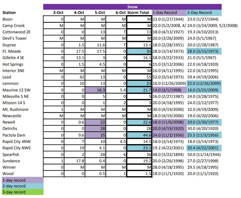
Map of snowfall over northeastern Wyoming and western South Dakota from October 3-5, 2013. Snow measurements the National Weather Service's official volunteer observing network are listed below. Observers record data once a day either in the morning or in the evening, which accounts for differences in the amounts for each day.
| Location | Daily Snowfall (inches) | Storm Total | |||
| Oct 3 | Oct 4 | Oct 5 | Oct 6 | ||
| Bear Ridge (8 W Spearfish) | 11.0 | 22.0 | 25.0 | 0.0 | 58.0 |
| Lead | 0.0 | 42.0 | 13.0 | 0.0 | 55.0 |
| Pactola | 0.0 | 9.6 | 35.0 | 0.0 | 44.6 |
| Spearfish | 0.0 | 2.0 | 28.0 | 6.0 | 36.0 |
| Piedmont | 0.0 | 31.0 | 4.0 | 0.0 | 35.0 |
| Belle Fourche | 0.0 | 1.0 | 24.0 | 7.0 | 32.0 |
| Hill City | 0.0 | 8.0 | 24.0 | 0.0 | 32.0 |
| Plainview | 0.0 | T | 26.0 | 4.0 | 30.0 |
| Fort Meade (Sturgis) | 0.0 | 17.5 | 11.5 | 0.0 | 29.0 |
| Oelrichs | 0.0 | 0.0 | 28.0 | 0.0 | 28.0 |
| Elm Springs 3 ESE | 0.0 | 0.0 | 25.0 | 0.6 | 25.6 |
| Oglala | 0.0 | 1.0 | 24.0 | T | 25.0 |
| Lodgepole | 0.0 | 0.0 | 24.0 | 0.0 | 24.0 |
| Rapid City NWS | 0.0 | 19.0 | 4.1 | 0.0 | 23.1 |
| Lemmon | 0.0 | 10.0 | 13.0 | 0.0 | 23.0 |
| Newell | 0.0 | 0.6 | 22.0 | 0.0 | 22.6 |
| Bison | 0.0 | 1.0 | 18.0 | 3.0 | 22.0 |
| Opal | 0.0 | 0.0 | 16.3 | 5.4 | 21.7 |
| Glad Valley | 0.0 | 0.0 | 16.0 | 4.0 | 20.0 |
| Upton | 0.0 | 18.0 | 2.0 | 0.0 | 20.0 |
| Sundance | 1.0 | 17.8 | 0.4 | 0.0 | 19.2 |
| Red Owl | 0.0 | 0.0 | 18.0 | 0.0 | 18.0 |
| Wright 12 W | 0.0 | 12.5 | 4.8 | 0.0 | 17.3 |
| Interior 3 NE (Badlands) | 0.0 | 1.0 | 16.0 | 0.0 | 17.0 |
| Ludlow | 0.0 | 9.0 | 8.0 | 0.0 | 17.0 |
| Gillette 4 SE | 0.0 | 13.1 | 3.0 | 0.0 | 16.1 |
| Hulett | 0.0 | 14.0 | 2.0 | 0.0 | 16.0 |
| Rapid City 4 NW | 0.0 | T | 10.0 | 4.5 | 14.5 |
| Dupree 15 SSE | 0.0 | 0.0 | 12.0 | 2.0 | 14.0 |
| Dupree | 0.0 | 1.5 | 11.6 | T | 13.1 |
| Cottonwood | 0.0 | 0.0 | 13.0 | T | 13.0 |
| Hoover | 0.0 | 1.0 | 12.0 | 0.0 | 13.0 |
| Dillinger (13 SE Rozet) | 0.0 | 10.3 | 2.0 | 0.0 | 12.3 |
| Harding 3SE | 0.0 | 0.1 | 10.0 | 0.0 | 10.1 |
| Wasta | 0.0 | 0.0 | 0.0 | 10.0 | 10.0 |
| Ardmore | 0.0 | 6.0 | 2.6 | 0.0 | 8.6 |
| Camp Crook | 0.0 | 6.0 | 2.0 | 0.0 | 8.0 |
| Edgemont | 0.0 | T | 8.0 | 0.0 | 8.0 |
| Kyle 2 E | 0.0 | 0.0 | 8.0 | 0.0 | 8.0 |
| Martin | 0.0 | 0.0 | 8.0 | 0.0 | 8.0 |
| Oral | 0.0 | 0.0 | 8.0 | 0.0 | 8.0 |
| Edgemont 23 NW | 0.0 | 1.0 | 6.0 | 0.0 | 7.0 |
| Weston | 0.0 | 7.0 | 0.0 | 0.0 | 7.0 |
| Cedar Butte | 0.0 | 0.0 | 4.0 | 2.0 | 6.0 |
| Hot Springs | 0.0 | 1.5 | 4.5 | 0.0 | 6.0 |
| Ladner | 0.0 | 5.0 | 1.0 | 0.0 | 6.0 |
| Wind Cave | 0.0 | 2.0 | 4.0 | 0.0 | 6.0 |
| Milesville 5 NE | 0.0 | 0.0 | 5.0 | 0.0 | 5.0 |
| Newcastle | 0.0 | 1.2 | 3.8 | 0.0 | 5.0 |
| Mission 14 S | 0.0 | 0.0 | 1.0 | 2.0 | 3.0 |
| Wood | 0.0 | 0.0 | 0.5 | 1.0 | 1.5 |
| Kirley 6 N | 0.0 | 0.0 | 1.0 | T | 1.0 |
| Winner | 0.0 | 0.0 | T | T | 0.0 |
| Rank | Maximum 1 Day Snowfall Total |
Date |
| 1 | 20.0 | 4/18/1970 |
| 2 | 19.2 | 4/22/2001 |
| 3 | 19.0 | 10/4/2013 |
| Rank | Maximum 3 Day Snowfall Total |
Date |
| 1 | 25.6 | 4/14/1927 |
| 2 | 23.1 | 10/5/2013 |
| 3 | 22.4 | 4/10/2013 |
| Rank | Maximum 1 Day Snowfall Total for October |
Date |
| 1 | 19.0 | 10/4/2013 |
| 2 | 9.9 | 10/19/1919 |
| 3 | 7.0 | 10/20/1906 |
| Rank | Maximum October Monthly Snowfall Total |
Date |
| 1 | 23.1 | 2013 |
| 2 | 15.1 | 1919 |
| 3 | 9.5 | 1932 |