Heavy to excessive rainfall may bring flooding to parts of Arizona, New Mexico, Florida, North Carolina, and Virginia today. Recently burned areas will be particularly vulnerable to flash flooding. Gusty winds and low humidity will bring elevated to critical fire weather conditions to parts of the Northwest U.S. and central Alaska today. Read More >
Overview
In the early evening of August 17, 2007, an intense thunderstorm developed along the eastern foothills of the Black Hills in central Custer County south of Rapid City. Southeasterly low-level winds fed moist air into the storm to help it grow. The thunderstorm remained nearly stationary for at least two hours, producing heavy rain over the same area.
Around 7:00 pm MDT, National Weather Service Doppler Radar in New Underwood, SD, estimated one to three inches of rain had fallen over Battle Creek from seven miles west of Hermosa to Hermosa, prompting a Flash Flood Warning for central Pennington County and northeastern Custer County issued at 7:09 pm MDT with another three inches of rain expected through 8:00 pm. The rain continued through the evening, with most of the rain falling before 9:00 pm.
Approximately 100 square miles were estimated to have received at least two inches of rain, while radar estimates indicated approximately 50 square miles received four to seven inches of rain. An automated rain gauge in Hermosa measured 0.86 inches of rain in 15 minutes between 7:30 pm and 7:45 pm. A rain gauge in Ghost Canyon west of Hermosa measured 5.33 inches and a gauge in Hermosa collected 5.5 inches of rain.
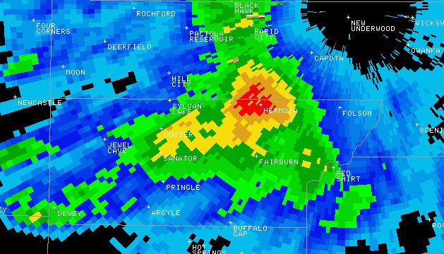
The Doppler radar image below shows estimated storm-total rainfall. The red area around Hermosa represents five to seven inches of rain that fell in Battle Creek and Grace Coolidge Creek, which flows into Battle Creek above SD Highway 79 south of Hermosa.
Flooding
Battle Creek just upstream of SD Highway 79 rose sharply from around two feet to a crest of almost 15 feet. A higher crest may have occurred between 8:45 pm and 9:15 pm, but the river gage only makes measurements every 15 minutes. Note all observations are preliminary and are provided by the U.S. Geological Survey (USGS), who owns and maintains the station.
The large amount of precipitation from this storm in such a short period of time caused flash flooding across north-central Custer County. The first report of flash flooding occurred at 7:20 pm in Custer and five miles west of Hermosa when water covered Highway 40 and portions of Custer. Between 8:00 and 8:15 pm, Battle Creek overflowed its banks around Hermosa and covered Highway 40 in several locations within five miles of Hermosa. Between 7:30 pm and 9:00 pm, the creek rose over 12 feet. Around 9:00 pm law enforcement reported water flowing over Highway 79 where it crosses Battle Creek. Between 8:00 pm and 9:00 pm, water backed up along the west side of a railroad embankment in the southeastern portion of Hermosa. Flooding was reported along the southern portions of 2nd and 3rd streets, the eastern portion of Whitney Street and the eastern portion of Manning Street. At approximately 9:00 pm the railroad embankment failed, causing flood waters to sweep three houses from their foundations and flooding about 30 other homes in a subdivision on the southeast side of Hermosa. According to the Rapid City Journal, the storm damaged 60 to 70 homes around the Hermosa area. At least a half mile section of railroad tracks and the embankment as well as several roads and vehicles were damaged.
Hydrograph
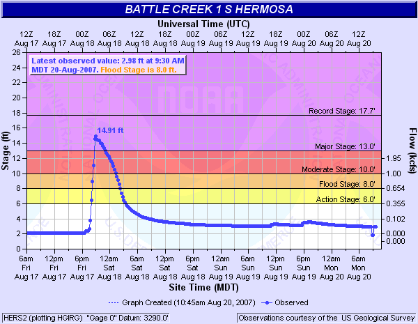 |
| Preliminary river stage data for Battle Creek at Hermosa |
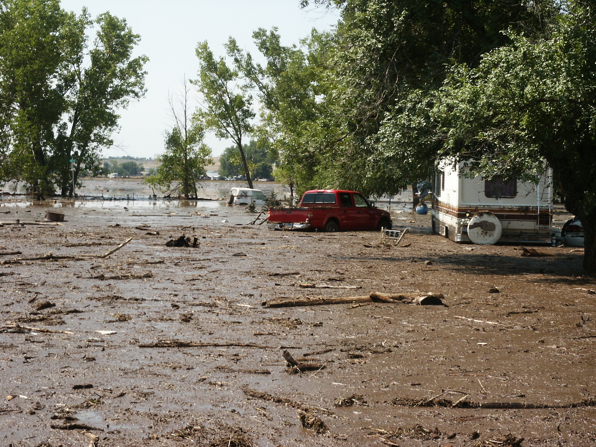
Photos
 |
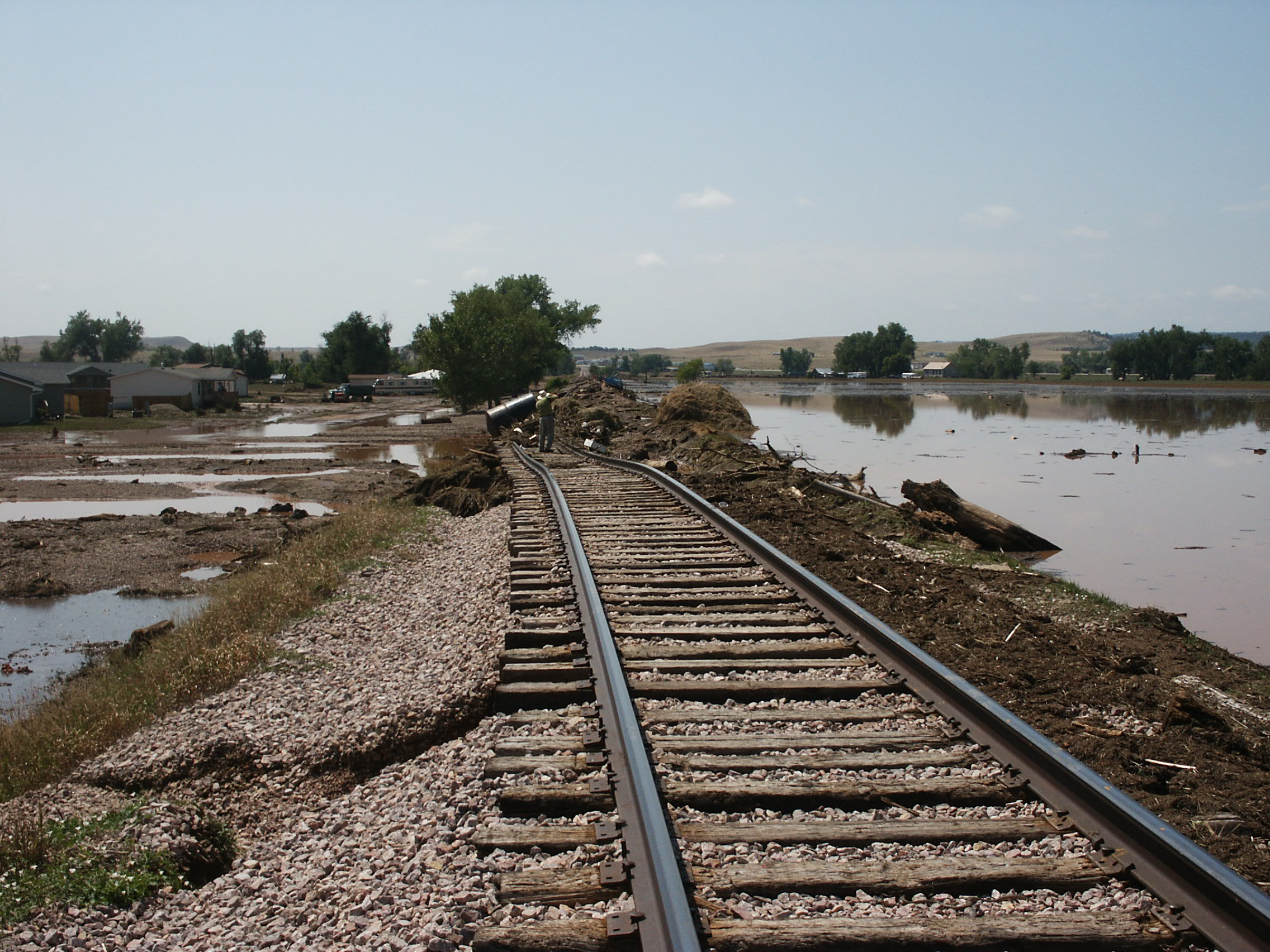 |
| Flooding behind the railroad embankment on the south side of Hermosa | Failure of the railroad bed on the south side of Hermosa |
Radar
The storm of interest developed just west of Hermosa and remained quasi-stationary for a few hours as other storms merged onto the western/southwestern flanks of the storm. This enhanced the rainfall duration and rate over Hermosa.
|
|
| Storm-total rainfall for the Hermosa area on August 17, 2017 (note rainfall scale below the image) |
| Radar animation from 5:12 pm to 10:00 pm MDT on August 17, 2007 |
Rain Reports
Below is a map of rain gage amounts and contours for the 12-hour period ending at midnight on August 18, 2007. The map is zoomed to a 15 x 15 mile square centered just west of Hermosa, SD. Blue lines indicate rivers and streams and the brown lines indicated state highways. The rainfall data were collected through the cooperative efforts of the USGS, NWS, and help of the general public. Most of the rain fell during the period from 5:30 pm to 8:30 pm MDT.
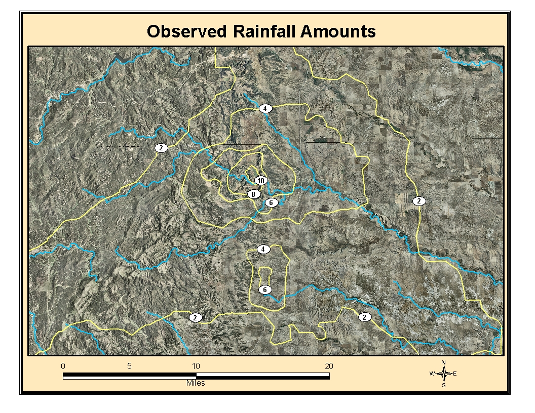 |
| Observed rainfall reports for Hermosa area ending at midnight August 18, 2007 |
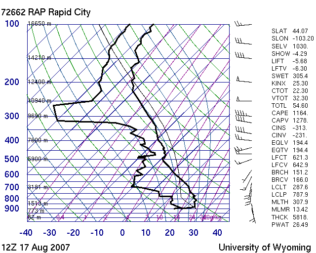
Environment
The atmosphere was very unstable and moist on the day of the Hermosa flood. The wind profile also favored slow-moving thunderstorms.
 |
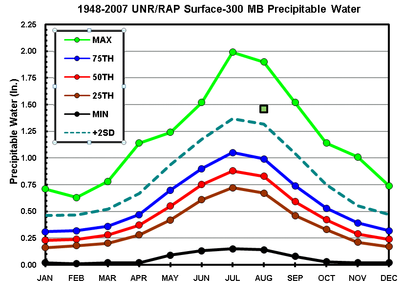 |
| 5:00 am MDT information from weather balloon released at NWS Rapid City | Chart showing atmospheric water vapor; green box is for Hermosa event |
There have been at least two research articles published about the Hermosa flood. One was published Melissa Smith (Service Hydrologist @ NWS Rapid City) and Meagan Holm (former Intern @ NWS Rapid City), and is titled "Rainfall Totals from the Hermosa Flash Flood of 17 August 2007". Much more information about the environment is contained within this article.
The other article was authored by the USGS, along with Matthew Bunkers (Science & Operations Officer @ NWS Rapid City), and is titled "Thunderstorms and flooding of August 17, 2007, with a context provided by a history of other large storm and flood events in the Black Hills area of South Dakota".
 |
Media use of NWS Web News Stories is encouraged! Please acknowledge the NWS as the source of any news information accessed from this site. |
|