Spring 2015 Highlights
| Jump To: | Temperatures | Precipitation | Drought Progression |
| Tulsa - Averages & Records | Fort Smith - Averages & Records | Fayetteville - Averages & Records | |
| Weather Highlights | Summer 2015 Outlook |
The following line graphs depict the mean temperature for the months of March - May (in blue) along with the expected mean temperature (in red) for Tulsa, OK, Fort Smith, AR and Fayetteville, AR. The mean temperatures were taken from 1980 - 2010.
 |
 |
 |
The spring months of 2015 were generally normal with respect to the temperatures, with all three climate sites remaining within two and a half degrees of average for March - May. March was a mix of slightly above and below normal temperatures, with Tulsa's average temperature 1.5 degrees above normal, and Fort Smith and Fayetteville falling slightly below normal at -0.4 degrees and -0.3 degrees. April was slightly above normal at all three sites, with Tulsa 2.3 degrees above normal, Fort Smith 1.9 degrees above normal, and Fayetteville 2.2 degrees above normal. The end of the spring 2015 season was slightly cooler than normal, with Tulsa -1.4 degrees below normal, Fort Smith -0.1 degrees below normal, and Fayetteville -0.3 degrees below normal.
The following bar graphs depict the mean precipitation for the months of March - May (in blue) along with the expected mean precipitation (in red) for Tulsa, OK, Fort Smith, AR and Fayetteville, AR. The mean precipitation amounts were taken from 1980 - 2010.
 |
 |
 |
The first two months of spring 2015 saw about average amounts of precipitation at the three climate sites, followed by a very wet and record breaking May. March totals generally ended up about a half inch above normal at all three sites (Tulsa +0.42", Fort Smith +0.65", Fayetteville +0.68"). April saw slightly above normal precipitation in Tulsa (+0.31"), and slightly below normal precipitation in Fort Smith (-0.01), and only about 60% of the expected precipitation in Fayetteville (-1.81"). May, however, saw record amounts of rainfall at all three climate sites, as a period of moderate to heavy rain developed during May 8-10, and also between May 23-29. Between 215% and 363% of the normal precipitation fell during the month of May across the three climate sites. Tulsa received 14.77", which is 8.86" above normal. Fort Smith recorded 19.85", which is 14.38" above normal. Fayetteville received 13.01", which is 6.97" above normal. This was the wettest May on record for Fort Smith, the 2nd wettest for Tulsa, and the 3rd wettest for Fayetteville.
The following bar graphs depict the mean snowfall for the months of March - May (in blue) along with the expected mean snowfall (in red) for Tulsa, OK, Fort Smith, AR and Fayetteville, AR. The mean snowfall amounts were taken from 1980 - 2010.
 |
 |
 |
Small amounts of snowfall were observed during early March, when 0.3" of snow fell in Tulsa, 1.0" of snow fell in Fort Smith, and 2.6" of snow fell in Fayetteville between March 4-5. No snow was recorded at any of the climate sites during the months of April or May.
The following chart depicts the amount of precipitation that fell leading up to, and during the spring months of 2015, and how that impacted the current drought across the area. The first image is the amount of rainfall that fell during the month (observed precipitation). The second image is the percentage of expected rainfall that fell during the month (percent of normal). The third image is the state of drought near the end of that month (drought progression).
| Observed Preciptation | Percent of Normal | Drought Progression | |
| February 2015 |  |
 |
|
| March 2015 |  |
 |
|
| April 2015 |  |
 |
|
| May 2015 |  |
 |
|
At the end of February 2015, most of eastern Oklahoma and all of northwest Arkansas remained in drought, ranging from D0 (abnormally dry) across much of the forecast area to D2 (severe drought) across portions of Osage, Pawnee, and Creek Counties. While above normal amounts of precipitation fell south and east of I-44 during the month of March 2015, below normal rain fell northwest of I-44. This served in reducing some of the slight drought conditions across southeast Oklahoma and northwest Arkansas, but drought conditions increased to D3 (extreme drought) across parts of Osage and Pawnee Counties. Below normal amounts of precipitation again occurred across northeast Oklahoma during April 2015, as well as across northwest Arkansas, while above normal rainfall fell across locations south of Highway 412. Thus, the D0 to D3 drought levels across northeast Oklahoma and northwest Arkansas remained, while additional slight drought conditions across southeast Oklahoma improved. Very heavy amounts of rain fell during May 2015, with much of southeast Oklahoma receiving over 300% of normal precipitation. Northeast Oklahoma and northwest Arkansas also received above normal amounts of rain, bringing an end to all of the drought across the forecast area, except a small area of D0 (abnormally dry) drought across far western Osage and far western Pawnee Counties.
Below are tables for Tulsa, OK, Fort Smith, AR and Fayetteville, AR with their monthly averages and records for temperatures and precipitation for the spring months of March - May, along with the spring seasonal averages. Below the tables are the daily temperature and precipitation records set this spring season.
Tulsa:
| Tulsa, OK |
Average Temperature |
Departure from Normal |
Rank | Record |
| March 2015 | 52.8°F | +1.5°F | 38th hottest | 61.5°F in 2012 |
| April 2015 | 62.9°F | +2.3°F | 29th hottest | 68.2°F in 1925 |
| May 2015 | 67.9°F | -1.4°F | 39th coldest | 60.8°F in 1907 |
| Spring Season 2015 | 61.2°F | +0.8°F | 34th hottest | 67.2°F in 2012 |
* April 7, tied the highest minimum temperature record of 68 degrees (other record from 2001).
* April 7, set a new highest average temperature record of 78 degrees (old record was 77 degrees from 1986, 2001).
*April 8, tied the highest minimum temperature record of 66 degrees (other records from 1999, 2001).
| Tulsa, OK | Precipitation | Departure from Normal | Rank | Record |
| March 2015 | 3.71" | +0.42" | 39th wettest | 11.94" in 1973 |
| April 2015 | 4.10" | +0.31" | 58th wettest | 9.33" in 2008 |
| May 2015 | 14.77" | +8.86" | 2nd wettest | 18.00" in 1943 |
| Spring Season 2015 | 22.58" | +9.59" | 3rd wettest | 24.46" in 1973 |
* May 23, set a new daily precipitation record of 3.36" (old record was 1.47" from 1947).
| Tulsa, OK | Snowfall | Departure from Normal | Rank | Record |
| March 2015 | 0.3" | -1.8" | 34th snowiest | 19.7" in 1924 |
| April 2015 | 0.0" | -Trace | - | 1.7" in 1957 |
| May 2015 | 0.0" | 0.0" | - | Trace in 2013 |
| Spring Season 2015 | 0.3" | -1.8" | 36th snowiest | 19.7" in 1924 |
* No daily snowfall records were set or tied during the spring season in Tulsa, OK
| Fort Smith, AR | Average Temperature | Departure from Normal | Rank | Record |
| March 2015 | 52.5°F | -0.4°F | 74th coldest | 41.4°F in 1960 |
| April 2015 | 63.5°F | +1.9°F | 32nd hottest | 68.0°F in 1896 |
| May 2015 | 69.8°F | -0.1°F | 68th coldest | 63.6°F in 1907 |
| Spring Season 2015 | 61.9°F | +0.5°F | 43rd hottest | 69.0°F in 2012 |
* March 25, tied the highest maximum temperature record of 86 degrees (other record from 1910).
| Fort Smith, AR | Precipitation | Departure from Normal | Rank | Record |
| March 2015 | 4.50" | +0.65" | 34th wettest | 13.03" in 1945 |
| April 2015 | 4.29" | -0.01" | 81st driest | 0.36" in 1903 |
| May 2015 | 19.85" | +14.38" | 1st wettest | 19.85" in 2015 |
| Spring Season 2015 | 28.64" | +15.02" | 1st wettest | 28.64" in 2015 |
* March 13, set a new daily precipitation record of 1.42" (old record was 1.14" from 1953).
* April 13, set a new daily precipitation record of 2.52" (old record was 1.47" from 1967).
* May 10, set a new daily precipitation record of 3.96" (old record was 3.93" from 1943).
| Fort Smith, AR | Snowfall | Departure from Normal | Rank | Record |
| March 2015 | 1.0" | +0.4" | 21st snowiest | 7.5" in 2010 |
| April 2015 | 0.0" | 0.0" | - | 0.7" in 1933 |
| May 2015 | 0.0" | 0.0" | - | - |
| Spring Season 2015 | 1.0" | +0.4" | 21st snowiest | 7.5" in 2010 |
* March 4, set a new daily snowfall record of 1.0" (old record was 0.3" from 1920, 1989).
| Fayetteville, AR | Average Temperature | Departure from Normal | Rank | Record |
| March 2015 | 47.8°F | -0.3°F | 33rd coldest | 37.5°F in 1960 |
| April 2015 | 59.0°F | +2.2°F | 25th hottest | 64.3°F in 1981 |
| May 2015 | 64.8°F | -0.3°F | 28th coldest | 60.1°F in 1976 |
| Spring Season 2015 | 57.2°F | +0.5°F | 28th hottest | 63.0°F in 2012 |
* March 24, tied the highest maximum temperature record of 79 degrees (other records from 1959, 1997).
* March 25, tied the highest maximum temperature record of 78 degrees (other records from 1989, 1991, 2007, 2012).
* April 8, tied the highest minimum temperature record of 66 degrees (other record from 2001).
| Fayetteville, AR | Precipitation | Departure from Normal | Rank | Record |
| March 2015 | 4.63" | +0.68" | 19th wettest | 10.05" in 2008 |
| April 2015 | 2.76" | -1.81" | 15th driest | 0.14" in 1989 |
| May 2015 | 13.01" | +6.97" | 3rd wettest | 13.39" in 1957 |
| Spring Season 2015 | 20.40" | +5.84" | 6th wettest | 28.81" in 2011 |
* March 25, set a new daily precipitation record of 1.14" (old record was 0.90"" from 1997).
* May 8, set a new daily precipitation record of 1.99" (old record was 1.49" from 1995).
* May 24, set a new daily precipitation record of 1.88" (old record was 1.52" from 1991).
| Fayetteville, AR | Snowfall | Departure from Normal | Rank | Record |
| March 2015 | 2.6" | +1.2" | 14th snowiest | 15.0" in 1968 |
| April 2015 | 0.0" | 0.0" | - | 1.0" in 1957 |
| May 2015 | 0.0" | 0.0" | - | 0.5" in 2013 |
| Spring Season 2015 | 2.6" | +1.2" | 14th snowiest | 15.0" in 1968 |
* March 4, set a new daily snowfall record of 2.6" (old record was 1.0" from 1964).
Here are a few of the more significant events of the spring season 2015, including winter weather, heavy rain, and severe weather.
March:
 |
 |
 |
|
March 4 Winter Weather Photo Credit: NWS Tulsa |
March 25 Severe Weather Photo Credit: NWS Tulsa |
March 31 Severe Weather Photo Credit: NWS Tulsa |
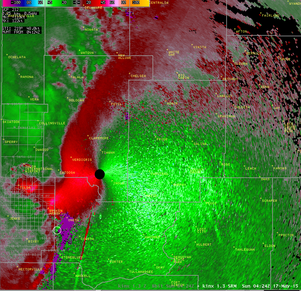
March 2015 started out colder than normal, with a winter weather system bringing a mix of sleet, snow, and freezing rain to much of eastern Oklahoma and western Arkansas. The precipitation began during the morning hours of March 4th, and persisted into the evening. Sleet and snow accumulations ranged from 3-4 inches across far northeast Oklahoma into northwest Arkansas, to 1-2 inches across much of eastern and southeast Oklahoma, with the Tulsa area receiving about a half inch (image above left). The three climate sites recorded 0.3" at Tulsa, 1.0" at Fort Smith, and 2.6" at Fayetteville. The middle part of March was mainly quiet, with seasonal temperatures. Heavy amounts of rain fell on March 13th, followed by the first severe weather outbreak on March 25th. Severe thunderstorms developed during the afternoon hours of March 25th, near a warm front that had surged northward into northeast Oklahoma and northwest Arkansas. With a highly sheared and unstable air mass in place across the area, discrete supercells were able to develop near the warm front late in the afternoon, and persist into the early evening hours. Many of the storms became severe, producing large hail to the size of softballs and damaging winds, as well as flash flooding across northeast Oklahoma and northwest Arkansas before exiting southeast Oklahoma and west central Arkansas. Several tornadoes were spawned from the supercells from west of Tulsa into northwest Arkansas, including an EF-2 in Sand Springs (image above center), an EF-0 in Tulsa, and an EF-1 near Clifty. More information about the severe weather on March 25th can be found here. Another round of severe weather developed at the end of the month, during the evening hours of March 31st, producing large hail up to 2.5" in diameter, as well as strong damaging winds, mainly within the counties of Okfuskee, Okmulgee, and McIntosh (image above right).
April:
 |
 |
 |
|
April 2-3 Severe Weather Photo Credit: NWS Tulsa |
April 9 Severe Weather Photo Credit: NWS Tulsa |
April 13 Heavy Rainfall Photo Credit: McAlester EM |
Severe weather developed across northeast portions of the forecast area during the evening hours of April 2nd along a stationary front that extended from north central Oklahoma into southeast Kansas. This activity affected locations north of Highway 412 in northeast Oklahoma and far northwest Arkansas during the evening and overnight hours. Supercells quickly developed due to plenty of instability and shear present in the atmosphere, producing large hail to the size of golf balls, and winds strong enough to damage several roofs and blow tractor trailer trucks over on I-44. An EF-1 tornado also formed during this event near the town of Afton (image above left). More information about the severe weather on April 2-3 can be found here. A second round of severe weather developed during the afternoon hours of April 9th, mainly affecting far eastern Oklahoma into western Arkansas (image above center). Several reports of hail were relayed to the National Weather Service office in Tulsa, with the largest being 1.25 inches in Le Flore County. A cold front moved into the region from the north on April 13th, triggering widespread showers and isolated thunderstorms across eastern Oklahoma and western Arkansas. The slow progression of the frontal boundary allowed heavy amounts of rainfall to accumulate as the large area of moderate to heavy rain shifted southward across the area. Precipitation amounts ranged from 0.95" in Tulsa, 2.52" in Fort Smith, 0.76" in Fayetteville, and 2.67" in McAlester. Several area saw flash flooding, including McAlester where a road was washed out due to the rapid rises on area creeks (image above center).
May:
 |
 |
|
|
May 10 Severe Weather Photo Credit: NWS Tulsa |
May 16 Severe Weather Photo Credit: NWS Tulsa |
May 2015 Record Rainfall Photo Credit: NOAA |
Several rounds of thunderstorms affected eastern Oklahoma and western Arkansas between May 8-10, as a strong upper level storm system slowly moved out of the southwestern United States and into the Central Plains. The event ended the night of May 10th, as an associated cold front finally pushed southeastward into Central Arkansas. Multiple reports of strong damaging winds and large hail were relayed to the National Weather Service. One particular storm that tracked northeast across southeast Oklahoma developed several tornadoes, including an EF-0 north of Moyers, an EF-2 southwest of Red Oak (image above left), and an EF-0 north of Red Oak. More information about the severe weather on May 10th can be found here. Scattered severe thunderstorms developed across the area ahead of line of storms moving eastward out of central Oklahoma during the evening of May 16th. The cells and the line merged over Tulsa County and produced a large bow echo along with tornadoes near the comma-head (image above center). That system continued producing damaging winds and tornadoes as it moved northeast into southwest Missouri. More information about the severe weather on May 16th can be found here. A progressive weather pattern developed during the month of May, allowing several low pressure systems to pass across the Southern Plains bringing heavy amounts of rainfall to the area. Much of southeast Oklahoma received 20 inches of rain or more during the month, causing flash flooding, as well as areal and river flooding (image above right). Tulsa recorded 14.77" during the month, making May 2015 the 2nd wettest on record, Fort Smith recorded 19.85" (1st wettest), Fayetteville recorded 13.01" (3rd wettest), McAlester recorded 22.98" (1st wettest).
Below are images of the Climate Prediction Center's forecasts for both temperatures and precipitation for the next three months (June - August), along with the Seasonal Drought Outlook for the summer months through August 31. For temperatures (left), there is an enhanced chance of below normal temperatures across all of eastern Oklahoma and western Arkansas. This does not mean that there will not be any hot periods during this time frame, but that the temperature averaged over the entire summer season has an increased chance of being cooler than normal. For precipitation (center), all of eastern Oklahoma and western Arkansas lie within an area of enhanced precipitation potential. This means that precipitation amounts averaged over the entire summer period are expected to be above normal. The third image depicts the drought outlook for the nation through the end of August. All of our forecast area (eastern Oklahoma and western Arkansas) is within the white area of "no drought posted or predicted", indicating this area is not under a D1 or greater drought, and is not expected to develop drought conditions. A small portion of far western Osage and Pawnee Counties remains under a D0 drought (Abnormally Dry), but these slight drought conditions are expected to improve.
 |
 |
 |
| Summer 2015 Temperature Outlook | Summer 2015 Precipitation Outlook | Summer 2015 Drought Outlook |
Updated: July 13, 2015


