|
March 12, 2006 Tornado Event
Last updated March 22, 2006
|
|
Thunderstorms erupted along a dry line that extended from Central Kansas through Central Oklahoma during the early evening hours of March 12th. These thunderstorms rapidly became severe in the unstable airmass that was in place across Eastern Oklahoma and Northwest Arkansas. The thunderstorms began to exhibit supercell characteristics shortly after they became severe. A PDS Tornado Watch was issued at 1245 pm March 12th for most Eastern Oklahoma and Northwest Arkansas through 10pm March 12th. |
 Initial Mesoscale Discussion from SPC |
 PDS Tornado Watch #74 |
 Reflectivity Loop from 6-11pm March 12th |
|
It has been determined by the National Weather Service storm survey teams that there were four tornadoes on the night of March 12th across far Eastern Oklahoma and Northwest Arkansas. Below are the preliminary details on each tornado: Tornado One: Touched down at 909pm, March 12, 2006 in Northwest Cherokee County Oklahoma...1 mile north of Peggs. The tornado traveled 29 miles at speeds of near 60 mph and attained a maximum width of 0.25 miles. The tornado was rated an F-3 on the Fujita scale based on damage 4 miles West-Southwest of Colcord, Oklahoma. The tornado lifted at 942 pm...4 miles northwest of Colcord. The tornado damaged 67 homes in the Twin Oaks and Colcord areas...destroying 36 of the homes. Five businessess were damaged in the same area. Eight people were injured...none life-threatening. Tornado Two:(updated 3/22/2006) A survey team spent the afternoon of March 22nd in far southeast Delware county Oklahoma where radar data had suggested that tornado damage may have occurred. Information provided by local officials and spotters in the region narrowed the search area and additional tornado damage was found...beginning about 2 miles southeast of Colcord. This damage appears to be associated with the aforementioned tornado 2...thus details of tornado 2 have been modified. Tornado 2 touched down at 937 pm, March 12, 2006 in southeastern Delaware County Oklahoma...about 3 miles southeast of Colcord. The tornado traveled about 22 miles at speeds near 45 mph and attained a maximum width of 0.4 miles. The tornado was rated F-3 on the Fujita scale based on damage to homes 2 to 3 miles southwest of Centerton Arkansas. The tornado lifted at 1008pm...4 miles west of the Bentonville Airport. The tornado damaged approximately 175 homes...41 reported destroyed. There were approximately 12 injuries...none life-threatening. The new damage also suggests that two tornadoes occurred simultaneously for a short period of time in southeast Delaware county. Tornado Three: Touched down at 1011pm, March 12, 2006...near Interstate 540 and Highway 62 just southwest of Bentonville in Benton County Arkansas. The tornado has a path length of 5 miles...and a maximum width of 250 yards before lifting at 1020pm 1.4 miles south of Avoca. Based on damage estimates this tornado was rated an F-2 on the Fujita scale. Tornado Four: Touched down at 1050pm, March 12, 2006...6.0 miles northwest of Urbanette in Northwest Carroll County Arkansas. The tornado had a path length of 3.0 miles...and a maximum width of 200 yards before lifting at 1055pm 5.4 miles north of Urbanette. The damage occurred in mostly open rural areas...damaging mainly trees and slightly damaging a few homes. Based on damage estimates this tornado was rated an F-1 on the Fujita scale. |
 |
 Detailed Track Of Northern Cherokee/Southern Delaware Tornado |
 WSR 88-D Reflectivity of Tornado as it moves near Twin Oaks, Oklahoma |
 WSR 88-D Reflectivity of Tornado as it moves near Bloomfield, Arkansas |
 WSR 88-D Reflectivity of Tornado as it moves near Bentonville, Arkansas |
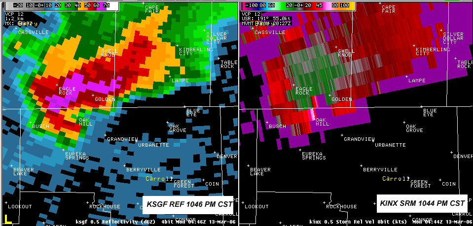
 WSR 88-D Reflectivity of Tornado as it moves across far northern Carroll County Arkansas |
|
Animated Radar Images
Images are large and may take some time to download |
|
Damage Photos - Tornado One |
 Near Twin Oaks |
 Near Twin Oaks |
 Near Twin Oaks |
 Near Kansas |
 Near Kansas |
 Near Kansas |
|
Damage Photos - Tornado Two |
 Near Centerton Near Centerton |
 Near Centerton Near Centerton |
 Near Centerton Near Centerton |
 Near Centerton Near Centerton |
 Near Centerton Near Centerton |
|
|
Damage Photos - Tornado Three |
 Near Bentonville/Little Flock Near Bentonville/Little Flock |
 Near Bentonville/Little Flock Near Bentonville/Little Flock |
 Near Bentonville/Little Flock Near Bentonville/Little Flock |
 Near Bentonville/Little Flock Near Bentonville/Little Flock |

