April 27, 2014 Quapaw and Octavia Tornado Event
( page last updated 10:30 am 4/30/2014 )
Information on this webpage is considered preliminary. Anyone with information that could enhance the record of these storms should contact the National Weather Service Office in Tulsa at 918-838-7838 during business hours or send us an email at: sr-tsa.stormreport@noaa.gov. Information can also be posted on our Facebook page.
Event Summary - 27 April 2014 Quapaw and Octavia Tornado Event
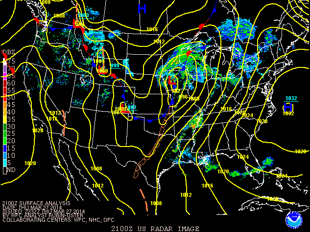
A powerful upper level storm system moved into the Plains on Sunday April 27th 2014. This storm helped to produce an initial round of thunderstorms early in the morning out over western and central OK which moved into eastern OK and northwest AR during the day. Other storms developed farther east in AR as well. The morning storms left an outflow boundary that stretched from central AR to near Fort Smith and then arced back to the northwest into far northeast OK. A Pacific front/dryline mixed east into eastern OK by mid-afternoon…and was the focus for discrete storm development. This boundary wavered back and forth into the evening hours…helping to develop another more linear round of thunderstorms during the evening hours.

Surface map at 4pm CST Sunday Apr 27, 2014 (From WPC)
Tornado Information (last updated 10:00 am 4/30/14):
| Quapaw Tornado (Ottawa County OK) |
| EF-Scale |
EF-2 |
| Maximum Estimated Wind Speed |
115 to 130 mph |
| Path Length |
11.25 miles (7 miles in Oklahoma) |
| Maximum Path Width |
325 yards |
| Start Time and Location |
2 miles SW of Quapaw, OK 529 PM CDT Sunday April 27, 2014 |
| End Location (in Oklahoma) and Times |
3 miles NE of Quapaw, OK (on KS border) at 542 PM CDT Sunday April 27, 2014
The tornado continued on into the Baxter Springs Kansas Area. |
| Fatalities |
1 |
| Injuries |
around 12, 7 serious |
| NWS DAMAGE SURVEY Information |
SURVEY SUMMARY: NATIONAL WEATHER SERVICE TULSA METEOROLOGISTS
SURVEYED TORNADO DAMAGE IN AND AROUND QUAPAW, OKLAHOMA, TODAY. THE
TORNADO APPARENTLY BEGAN OVER OPEN COUNTRY SOUTHWEST OF A RANCH
HOME 3.4 MILES SOUTHWEST OF QUAPAW. THE FIRST DAMAGE FROM THE
TORNADO WAS THAT RANCH HOME...WHICH LOST NUMEROUS SHINGLES...A
NEARBY BARN WAS DAMAGED...A MOBILE HOME HAD SIDING REMOVED...AND
LARGE TREE LIMBS WERE SNAPPED IN THIS AREA. THE TORNADO MOVED
NORTHEAST AND SNAPPED SEVERAL POWER POLES AND HARDWOOD TREES.
BASED ON PHOTOGRAPHS...THE TORNADO HAD VERY LITTLE CONDENSATION
ASSOCIATED WITH IT UNTIL IT NEARED HIGHWAY 69A JUST OUTSIDE OF
QUAPAW...WHERE IT SNAPPED TREES AND DESTROYED A BARN.
THE TORNADO THEN MOVED INTO THE TOWN...WHERE IT SEVERELY DAMAGED
SEVERAL METAL BUILDING STRUCTURES...INCLUDING THE FIRE STATION.
NUMEROUS HOMES WERE SEVERELY DAMAGED...SEVERAL OF WHICH HAD THEIR
ROOFS BLOWN OFF. SEVERAL BUILDINGS IN TOWN WERE DESTROYED. TWO
PEOPLE WERE IN A VEHICLE THAT THEY PARKED RIGHT UP AGAINST ONE OF
THOSE BUILDINGS...IN AN ATTEMPT TO SHELTER THEMSELVES FROM THE
APPROACHING TORNADO. THE BRICK AND CONCRETE WALLS OF THE BUILDING
COLLAPSED ON TOP OF THE VEHICLE...CRUSHING IT AND KILLING A 68
YEAR OLD MALE AND INJURING A FEMALE. SEVERAL OTHER VEHICLES IN
THIS AREA WERE DAMAGED FROM FLYING DEBRIS. ABOUT A DOZEN INJURIES
OCCURRED IN TOWN...SEVEN OF WHICH WERE SERIOUS ENOUGH TO WARRANT
BEING TRANSPORTED TO MEDICAL FACILITIES. NUMEROUS TREES AND POWER
POLES WERE SNAPPED.
THE TORNADO CONTINUED TO MOVE NORTHEAST FROM QUAPAW...SNAPPING
NUMEROUS TREES AND POWER POLES...AND DAMAGING HOMES AND
OUTBUILDINGS. THE ENDING POINT NOTED ABOVE IS WHERE IT CROSSED
INTO KANSAS. THE NATIONAL WEATHER SERVICE OFFICE IN SPRINGFIELD
SURVEYD THE DAMAGE FOR THE KANSAS SEGMENT OF THIS TORNADO AND
CONCLUDED THAT THE TORNADO WAS ON THE GROUND FOR ANOTHER 4.25
MILES. THE KANSAS SEGMENT OF THIS TORNADO WAS ALSO RATED EF-2 DUE
TO DAMAGE THAT OCCURRED IN AND AROUND BAXTER SPRINGS.
|
| Octavia Tornado (LeFlore County OK) |
| EF-Scale |
EF-1 |
| Maximum Estimated Wind Speed |
95 to 105 mph |
| Path Length |
1.5 miles |
| Maximum Path Width |
250 yards |
| Start Time and Location |
1.5 miles NNW of Octavia, OK 531 PM CDT Sunday April 27, 2014 |
| End Location and Times |
2.2 miles NE of Octavia, OK at 534 PM CDT Sunday April 27, 2014 |
| Fatalities |
None |
| Injuries |
None |
| NWS DAMAGE SURVEY Information |
SURVEY SUMMARY: A METEOROLOGIST FROM THE NATIONAL WEATHER SERVICE
IN TULSA SURVEYED TORNADO DAMAGE NORTH OF OCTAVIA. THE TORNADO
SNAPPED OR UPROOTED A NUMBER OF TREES.
THE PRIMARY AREA OF DAMAGE FOUND WAS ALONG HIGHWAY 259.
DUE TO MUCH OF THE REMAINDER OF THE PATH BEING IN AREAS INACCESSIBLE
BY ROAD,THE BEGINNING AND ENDING POINTS WERE ESTIMATED BASED ON RADAR
AS WELL AS ROADS AROUND THE PERIPHERY OF THE ESTIMATED PATH
ON WHICH NO DAMAGE WAS FOUND.
|
Event Radar Images (last updated 10:00 am 4/30/14):
| Quapaw Tornado (Ottawa County OK) |
 |
 |
|
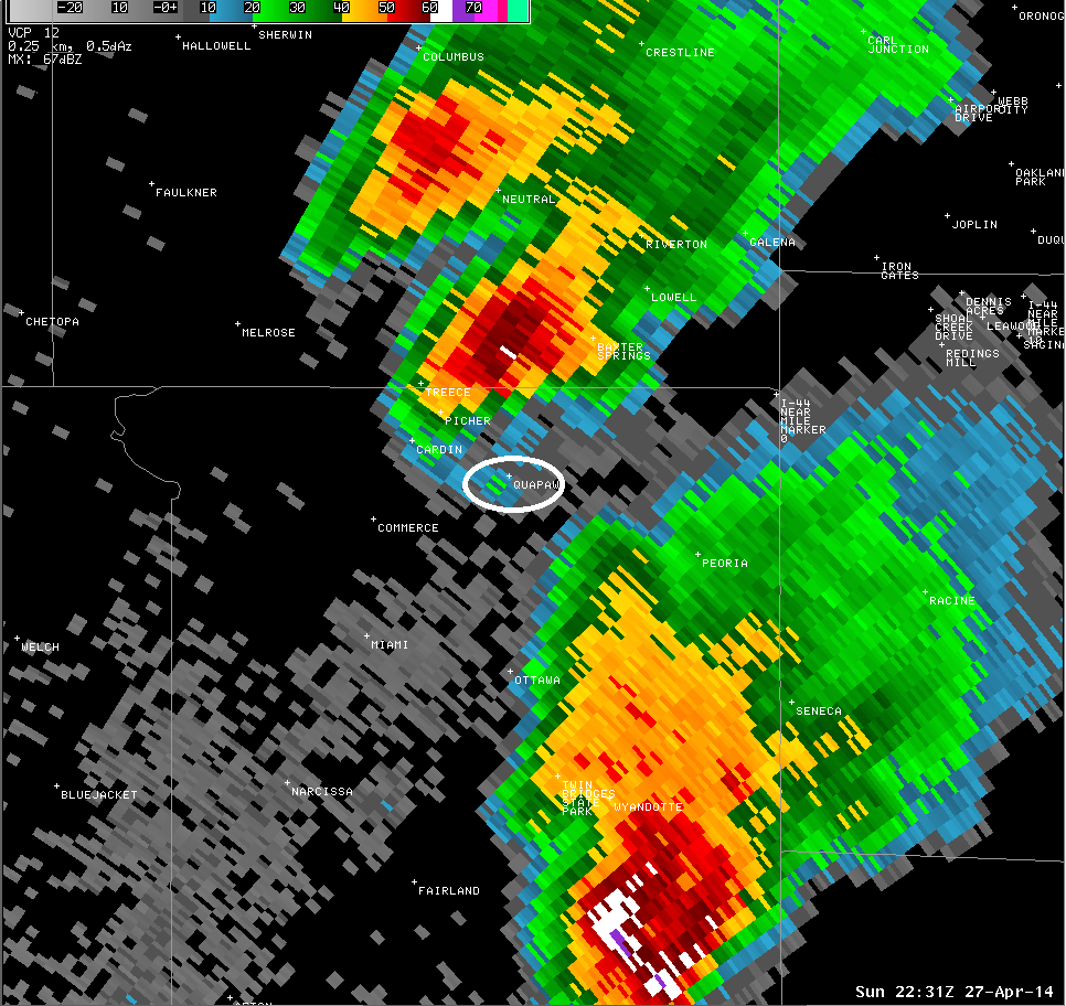
kinx reflectivity at 531pm. Quapaw is circled.
|
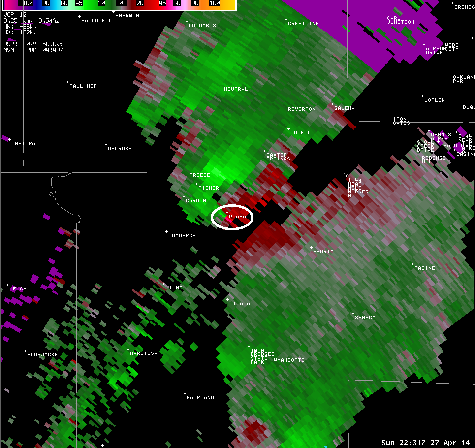
kinx storm relative velocity at 531pm. Quapaw is circled.
|
| Octavia Tornado (LeFlore County OK) |
 |
 |
|
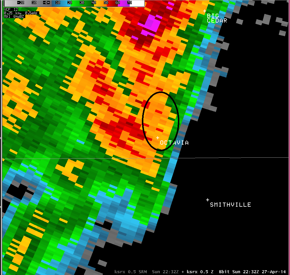
ksrx reflectivity at 532pm. Octavia is circled.
|
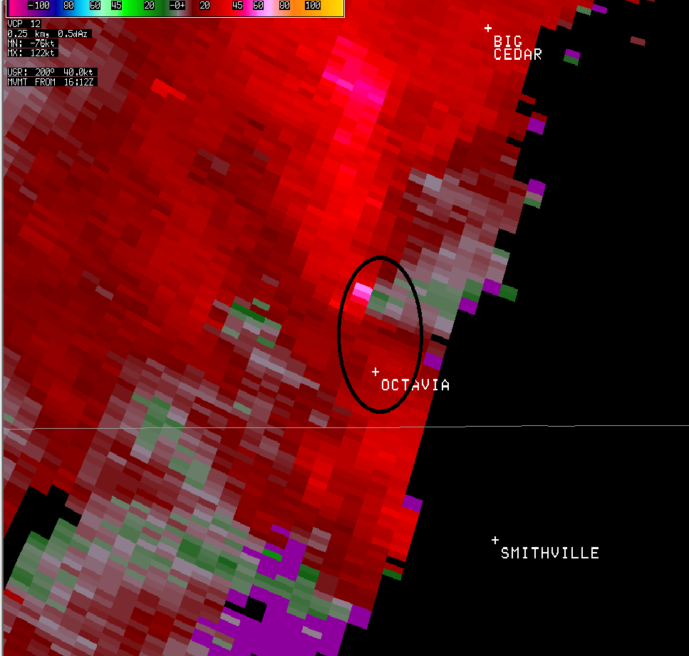
ksrx storm relative velocity at 532pm. Octavia is circled.
|
