May 2-4, 2013: Snow Event
|
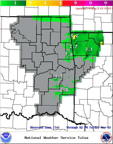
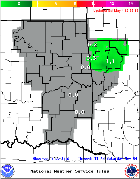
Strong upper-level highs over the Pacific Northwest and the northwest Atlantic funneled cold Canadian air southward into the Southern Plains on May 2, 2013. The cold front associated with this cold air moved through eastern Oklahoma and northwest Arkansas on May 2, with precipitation occurring along and behind the front. The unusually cold temperatures for May allowed for sleet and snow to mix in with the rain across northeast OK during the afternoon and evening hours of May 2. Snowflakes were first observed at the NWS Tulsa office at 1:40pm CDT, making May 2, 2013 the latest observed snow in Tulsa since records began in 1900. The previous latest observed snow in Tulsa was on April 18, 1953. This also marks the first time snow has fallen in Tulsa in the month of May. As the precipitation continued to move east overnight, heavier snow developed over far northeast Oklahoma, the higher elevations of southeast Oklahoma, and northwest Arkansas, where snowfall totals of 1" to 2" were common by the morning of May 3. The highest totals of 3"-5" occurred in Adair County, OK and Benton County, AR. This is the first time snow has fallen in the state of Arkansas during the month of May. Ironically, this latest snow on record follows the hottest year (2012) on record across eastern Oklahoma and northwest Arkansas. Additional snow occurred primarily over northwest Arkansas during the early morning hours of May 4 as precipitation wrapped around the upper-level low that was still near the Arkansas-Missouri state line. Overall, the snowfall on the 4th was much lighter than the previous night, though the higher elevations did receive near 2" of additional snow. May 4, 2013 will go down in the record books as the latest snowfall in Arkansas. |

Storm Total Snowfall
|
Records Broken during this Event:
| Tulsa: | Record | Date | Previous Record |
| Daily Snowfall | Trace | May 2, 2013 | 0.0" |
| Latest Snowfall | Trace | May 2, 2013 | Trace on April 18, 1953 |
| Highest May Snowfall | Trace | May 2, 2013 | Never snowed in May before |
| Daily Low Mean Temperature | 45°F | May 2, 2013 | 47°F in 2011 |
| Fort Smith: | |||
| Daily Low Min Temperature | 37°F | May 3, 2013 | 37°F in 2011 |
| Daily Low Mean Temperature | 48.0°F | May 3, 2013 | 49.0°F in 1954 |
| Daily Low Max Temperature | 49°F | May 4, 2013 | 52°F in 1935 |
| Daily Low Mean Temperature | 45.5°F | May 4, 2013 | 46.5°F in 1907 |
| Fayetteville: | |||
| Daily Snowfall | 0.5" | May 3, 2013 | 0.0" |
| Latest Measureable Snow | 0.5" | May 3, 2013 | 1.0" on April 12, 1957 |
| Latest Snowfall | 0.5" | May 3, 2013 | Trace on April 18, 1953 |
| Highest May Snowfall | 0.5" | May 3, 2013 | Never snowed in May before |
| Daily Low Max Temperature | 47°F | May 3, 2013 | 51°F in 1954 |
| Daily Low Mean Temperature | 39.5°F | May 3, 2013 | 43.0°F in 1954 |
| Daily Low Max Temperature | 44°F | May 4, 2013 | 51°F in 1978 |
| Daily Low Mean Temperature | 38.5°F | May 4, 2013 | 45.5°F in 1954 |
| Arkansas: | |||
| Latest Snowfall | May 4, 2013 (24-hr snowfall accumulation of 1.00" reported at 7am May 5, 2013 by NWS COOP observer WINA4 for snowfall that occurred on May 4, 2013) |
Trace on April 30, 1903 (at the Fayetteville Experimental Station (Washington County), in Gravette (Benton County) and in Harrison (Boone County)) |
Click on image for larger view in a new window.
 |
 |
 |
|
| Snowfall May 2-3, 2013 | Snowfall May 2-3, 2013 | Snowfall May 3-4, 2013 | Snowfall May 2-4, 2013 |
 |
 |
 |
 |
| Photo by Brenten Stevens in Fayetteville, AR. Courtesy of 5News/KFSM | Photo by Dave and Mary Bristow in Bentonville, AR. Courtesy of 5News/KFSM | Photo by Melissa Jones in Springdale, AR. Courtesy of 5News/KFSM | Photo by Rick Tollett in Lake Weddington, AR. Courtesy of 5News/KFSM |
 |
 |
 |
 |
| Photo by Rita Randall, near Decatur, AR. This picture was taken about an hour after the 5" snowfall was measured by the CoCoRaHS observer at this location. | Photo by Rita Randall, near Decatur, AR. This picture was taken about an hour after the 5" snowfall was measured by the CoCoRaHS observer at this location. | Photo by Taylor Farrell at the University of Arkansas campus. Courtesy of 5News/KFSM | Low temperatures on the morning of May 3, 2013 |
 |
 |
||
| Radar mosaic and surface observations at 1:42 pm CDT May 2, 2013, when snow was observed at the NWS Tulsa office. | Radar mosaic and surface observations at 3 am CDT May 3, 2013. |
Is the Ground Too Warm for Snow to Stick?
Leading up to this event, high temperaures on April 29, April 30, and May 1, 2013 were all in the 80s across eastern Oklahoma and northwest Arkansas. Likewise, 5cm soil temperatures had warmed into the 70s to low 80s across the area. There is almost always a warm ground discussion before snow in this part of the world. However, as seen on May 3, snow of sufficient intensity at night will accumulate despite ground temperatures well above freezing. With these conditions, the snow will not affect the roads too much, and 100% of the snow will not stick, but some will. In the below images of the Westville, OK mesonet soil temperature plots, there is the 40°F temperature drop at the 5 cm layer below bare ground.
 |
 |
|
...PRELIMINARY SNOW ACCUMULATION SUMMARY MAY 03 2013...
...PRELIMINARY SNOW ACCUMULATION SUMMARY MAY 04 2013... |
Updated: May 6, 2013

