December 20-21, 2013 Ice Storm
Information on this webpage is considered preliminary and will continue to be updated as the event is analyzed. You may need to refresh this website to see the latest information (including snowfall/ice estimates and other event images).
Anyone with information that could enhance the record of this storm should contact the National Weather Service Office in Tulsa at 918-838-7838 during business hours or send us an email at: sr-tsa.stormreport@noaa.gov.
 |
 |
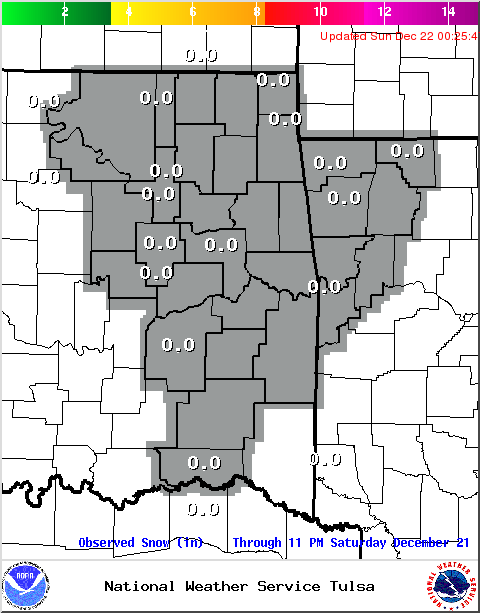
| Sleet/Snowfall Estimate (you may need to refresh this website for the latest image) | Ice Accumulation Estimate (you may need to refresh this website for the latest image) |
Event Summary (Updated 6pm 12/22/2013)
A significant ice storm impacted a large portion of Oklahoma extending from the southwestern portions of the state eastward through much of east central and northeast Oklahoma. The swath of accumulating ice also reached into extreme northwest portions of Arkansas. The weather event began as a strong cold pushed into northeast Oklahoma during the overnight hours on December 19, 2013. The post frontal air was cold, however, the depth of the cold temperatures remained very shallow, generally less than 1500 ft thick. This forced the cold front to stall upon impacting the higher terrain of northwest Arkansas into southeast Oklahoma, with locations south of the front remaining much warmer than locations north of the boundary. The location and magnitude of this cold front was a determining factor in the exact location of the heaviest icing and became a key feature during the forecast process.
A broad region of unseasonably high moisture was located across the Southern Plains ahead of the strong cold front. The upper air balloon launched from Fort Worth, TX Saturday morning (12/21/2013) sampled 1.32 inches of precipitable water. This is a measure of the total moisture available, and this amount is in the top 5% of precipitable water values observed during December for Fort Worth. This rich moisture was then lifted as a strong storm system tracked toward the region, with precipitation expanding into eastern Oklahoma Friday (12/20/2013) evening, and increasing in coverage and intensity Friday night through Saturday (12/21/2013). The shallow, yet very cold, nature of the airmass north of the cold front allowed widespread freezing rain to develop, with a swath of heavy icing along the Interstate 44 corridor and also across a portion of Osage County. Ice accumulations of 0.50-0.75 inches were reported in these areas. Further south, across southeast Oklahoma into extreme northwest Arkansas, icing accumulations of 0.25-0.50 inches were reported. The extensive icing extended west across much of Oklahoma, with the Oklahoma Mesonet reporting many frozen wind anemometers across the state. South of the cold front, temperatures remained warm enough to prevent icing, however localized flooding was reported with the widespread and long duration rainfall.
| Tulsa Snowfall Normals and Records | Fort Smith Snowfall Normals and Records | Fayetteville Snowfall Normals and Records |
Event Images
Image captions below the image. Click on image to open a larger version in a new window.
 |
 |
 |
|
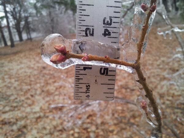
Ice measured near Sapulpa, OK. Image Credit: Craig Sullivan, NWS Tulsa |
Tree Damage in Owasso, OK Image Credit: Karen Hatfield, NWS Tulsa |
Ice Accumulation Near Owasso, OK Image Credit: Ed Calianese, NWS Tulsa |
 |
 |
 |
|
Wind speeds can not be reported due to frozen anemometers. Image Credit: Oklahoma Mesonet
|
Power lines down near ORU campus in Tulsa, OK Image Credit: FOX23 staff |
Ice on the Tulsa Golden Driller. Image Credit: JulieClemons |
PUBLIC INFORMATION STATEMENT
NATIONAL WEATHER SERVICE TULSA OK
757 PM CST SUN DEC 22 2013
...PRELIMINARY ICE ACCUMULATION SUMMARY DEC 22 2013...
...REPORTS SORTED BY AMOUNTS...
IN OKLAHOMA...
0.75 INCH OF ICE AT BLUEJACKET IN CRAIG COUNTY
0.70 INCH OF ICE 1 MILES WEST OF CATOOSA IN ROGERS COUNTY
0.60 INCH OF ICE 1 MILES WEST OF TALALA IN ROGERS COUNTY
0.60 INCH OF ICE AT GRAINOLA IN OSAGE COUNTY
0.50 INCH OF ICE 2 MILES SOUTHWEST OF TIAWAH IN ROGERS COUNTY
0.50 INCH OF ICE AT WHITE OAK IN CRAIG COUNTY
0.50 INCH OF ICE AT WYANDOTTE IN OTTAWA COUNTY
0.50 INCH OF ICE AT SCHULTER IN OKMULGEE COUNTY
0.50 INCH OF ICE 5 MILES EAST-SOUTHEAST OF OWASSO IN ROGERS COUNTY
0.50 INCH OF ICE AT CHECOTAH IN MCINTOSH COUNTY
0.50 INCH OF ICE AT OWASSO IN TULSA COUNTY
0.50 INCH OF ICE 3 MILES EAST OF SAPULPA IN CREEK COUNTY
0.50 INCH OF ICE AT GLENPOOL IN TULSA COUNTY
0.50 INCH OF ICE AT NOWATA IN NOWATA COUNTY
0.50 INCH OF ICE AT TULSA IN TULSA COUNTY
0.40 INCH OF ICE 6 MILES EAST-NORTHEAST OF OWASSO IN ROGERS COUNTY
0.40 INCH OF ICE AT BIXBY IN TULSA COUNTY
0.40 INCH OF ICE 7 MILES EAST OF BROKEN ARROW IN WAGONER COUNTY
0.37 INCH OF ICE 5 MILES EAST-SOUTHEAST OF TULSA IN TULSA COUNTY
0.37 INCH OF ICE 8 MILES NORTH OF MANNFORD IN OSAGE COUNTY
0.33 INCH OF ICE 4 MILES EAST-NORTHEAST OF TULSA IN TULSA COUNTY
0.30 INCH OF ICE 5 MILES SOUTHEAST OF TULSA IN TULSA COUNTY
0.30 INCH OF ICE AT GROVE IN DELAWARE COUNTY
0.30 INCH OF ICE AT MUSKOGEE IN MUSKOGEE COUNTY
0.25 INCH OF ICE 2 MILES SOUTHEAST OF COLLINSVILLE IN ROGERS COUNTY
0.25 INCH OF ICE AT HULBERT IN CHEROKEE COUNTY
0.25 INCH OF ICE AT BARTLESVILLE IN WASHINGTON COUNTY
0.25 INCH OF ICE 2 MILES SOUTH OF SAND SPRINGS IN TULSA COUNTY
0.25 INCH OF ICE 2 MILES NORTHWEST OF CLAREMORE IN ROGERS COUNTY
0.25 INCH OF ICE AT WARNER IN MUSKOGEE COUNTY
0.25 INCH OF ICE 4 MILES SOUTHEAST OF EUFAULA IN PITTSBURG COUNTY
0.20 INCH OF ICE AT HECTORVILLE IN OKMULGEE COUNTY
0.15 INCH OF ICE 3 MILES NORTH OF OWASSO IN TULSA COUNTY
0.13 INCH OF ICE 5 MILES WEST OF TULSA IN TULSA COUNTY
0.10 INCH OF ICE AT WELEETKA IN OKFUSKEE COUNTY
0.10 INCH OF ICE AT TAHLEQUAH IN CHEROKEE COUNTY
0.10 INCH OF ICE 4 MILES EAST OF ARPELAR IN PITTSBURG COUNTY
0.05 INCH OF ICE 4 MILES EAST OF COLCORD IN DELAWARE COUNTY
0.00 INCH OF ICE AT STONEBLUFF IN WAGONER COUNTY
0.00 INCH OF ICE AT BROKEN ARROW IN TULSA COUNTY
0.00 INCH OF ICE AT PEGGS IN CHEROKEE COUNTY
0.00 INCH OF ICE AT OKMULGEE IN OKMULGEE COUNTY
0.00 INCH OF ICE 7 MILES WEST OF SILOAM SPRINGS IN DELAWARE COUNTY
0.00 INCH OF ICE AT CLEVELAND IN PAWNEE COUNTY
0.00 INCH OF ICE AT CANADIAN IN PITTSBURG COUNTY
0.00 INCH OF ICE AT COLLINSVILLE IN TULSA COUNTY
0.00 INCH OF ICE AT FAIRFAX IN OSAGE COUNTY
0.00 INCH OF ICE AT BRISTOW IN CREEK COUNTY
IN ARKANSAS...
0.10 INCH OF ICE AT SILOAM SPRINGS IN BENTON COUNTY
0.10 INCH OF ICE AT DECATUR IN BENTON COUNTY
0.09 INCH OF ICE AT BELLA VISTA IN BENTON COUNTY

