December 5-6, 2013 Winter Storm and Ice Storm Event
Information on this webpage is considered preliminary and will continue to be updated as the event is analyzed. You may need to refresh this website to see the latest information (including snowfall/ice estimates and other event images).
Anyone with information that could enhance the record of this storm should contact the National Weather Service Office in Tulsa at 918-838-7838 during business hours or send us an email at: sr-tsa.stormreport@noaa.gov.
 |
 |
| Sleet/Snowfall Estimate as of 3pm CST 12/06/2013 (you may need to refresh this website for the latest image) | Ice Accumulation Estimate as of 3pm CST 12/06/2013 (you may need to refresh this website for the latest image) |
Event Summary (Updated 6pm 12/6/2013)
A major winter storm impacted eastern Oklahoma and northwest Arkansas, beginning early Thursday, December 5th, and continuing through late Friday, December 6th. Significant ice accumulations and sleet and snow accumulations occurred. An arctic cold front pushed through the region during the daylight hours Wednesday, December 4th, dropping temperatures from the 60s in some locations to below freezing in a matter of hours. Precipitation did not develop along the surface front, but instead, waited for a series of upper-level disturbances to move northeastward across eastern Oklahoma and northwest Arkansas on Thursday and Friday.
Freezing rain, mixed with sleet at times, developed through Thursday morning, primarily to the southeast of the Interstate 44 corridor. Temperatures were warm enough initially in far southeast Oklahoma and a small part of west central Arkansas that the precipitation began as rain before quickly transitioning to freezing rain by mid morning. Cold air gradually deepened from north to south during the afternoon and evening, allowing some of the freezing rain to transition to sleet and finally snow. Additional precipitation blossomed overnight Thursday and into Friday morning, bringing some of the first measurable snow or sleet to areas north of the Interstate 44 corridor, as well as locations in southeast Oklahoma and west central Arkansas that previously saw significant ice accumulation.
Far southeast Oklahoma and west central Arkansas were hardest hit with ice accumulation and related impacts. Areas from Hugo to Antlers, Poteau, and toward Greenwood and Ozark saw between a half inch and an inch of ice accumulation. Widespread power outages occurred. Snow and sleet accumulated to 3 to 6 inches across a large part of northeast Oklahoma, east central Oklahoma, and northwest Arkansas. The largest snow and sleet accumulations, a foot or more, were recorded in far northwest Arkansas across Benton and Carroll counties.
Officially, Tulsa, OK received 4.9", Fort Smith, AR 5.0", and Fayetteville, AR 7.0" of sleet and snow during this event.
| Tulsa Snowfall Normals and Records | Fort Smith Snowfall Normals and Records | Fayetteville Snowfall Normals and Records |
Event Images
Image captions below the image. Click on image to open a larger version in a new window.
 |
 |
 |
| Sperry-Piltz Ice Accumulation (SPIA) Index based on preliminary observed ice amounts as of 1pm CST 12/06/2013. We likely reached Level 5 in a narrow swath from southeast Oklahoma into west-central Arkansas. We have to do an observed ice analysis so agencies can continue to assess the situation. Some people will likely be out of power for more than 10 days. Fire and carbon monoxide safety has to be stressed in the ice storm area. | 6 miles ENE of Owasso, OK (Rogers County): 5" snowfall storm total.
Image Credit: Ed Calianese/NWS Tulsa |
Freezing Rain in Hugo, OK (Choctaw County) with accumulation on trees shown at 8:00am 12/06/2013. Ongoing severe damage.
Image Credit: @NAisOK twitter pic |
 |
 |
 |
| Numerous trees down in Cecil, AR (Franklin County) along Valley Creek Road.
Image Credit: Dana Howard via @5NEWSJoe twitter pic |
Ice accumulation in Hartford, AR (Sebastain County).
Image Credit: @5NEWSJoe twitter pic |
11 inches of snow in Pea Ridge, AR (Benton County).
Image Credit: Benton County Emergency Management @robert_mcgowen twitter pic |
 |
 |
 |
| View from NWS Tulsa at 8:30am CST 12/06/2013.
Image Credit: Steve Piltz/NWS Tulsa |
Car off the road on interstate 540 in Rogers next to Hammons Center.
Image Credit: @5NEWSTyler twitter pic |
Frozen branches in Spiro, OK (Le Flore County). Image Credit: Brittany Barnes @Blbarnes123 twitter pic |
 |
 |
 |
|
8" in Bella Vista, AR (Benton County). Image Credit: @nicolelinder81 twitterpic |
Trees with broken branches from ice in the Fort Smith, AR (34th street) area. Image Credit: iPIX Zena Chinos via @5NEWSGarrett twitter pic |
Ice in Hugo, OK (Choctaw County). Image Credit: Karen Bailey-Boone (via OAEC) |
 |
 |
 |
|
Ice in Hugo, OK (Choctaw County) Photo Credit: Melissa Methvin (via OAEC) |
Ice in Frogville, OK (Choctaw County) Photo Credit: Danielle and Tyson Houston (via OAEC) |
Ice damage in Rattan, OK (Pushmataha County) Photo Credit: Tammy Lawless (via OAEC) |
 |
||
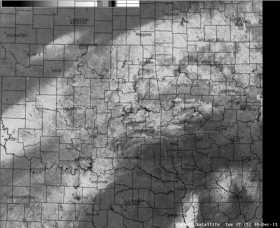
| Visible satellite image of snow across eastern Oklahoma and northwest Arkansas. Satellite image valid at 11:15am CST Dec. 10, 2013 |
PUBLIC INFORMATION STATEMENT
NATIONAL WEATHER SERVICE TULSA OK
239 PM CST FRI DEC 6 2013
...PRELIMINARY ICE ACCUMULATION SUMMARY DEC 06 2013...
...REPORTS SORTED BY AMOUNTS...
IN OKLAHOMA...
1.25 INCHES OF ICE AT FORT TOWSON IN CHOCTAW COUNTY
1.00 INCH OF ICE AT POTEAU IN LE FLORE COUNTY
1.00 INCH OF ICE AT ANTLERS IN PUSHMATAHA COUNTY
1.00 INCH OF ICE AT HUGO IN CHOCTAW COUNTY
0.50 INCH OF ICE AT OCTAVIA IN LE FLORE COUNTY
0.50 INCH OF ICE AT NASHOBA IN PUSHMATAHA COUNTY
0.50 INCH OF ICE AT SWINK IN CHOCTAW COUNTY
0.50 INCH OF ICE AT SOBOL IN PUSHMATAHA COUNTY
0.10 INCH OF ICE AT CHECOTAH IN MCINTOSH COUNTY
IN ARKANSAS...
1.25 INCHES OF ICE AT GREENWOOD IN SEBASTIAN COUNTY
1.00 INCH OF ICE 10 MILES EAST OF FORT SMITH IN CRAWFORD COUNTY
1.00 INCH OF ICE AT OZARK IN FRANKLIN COUNTY
1.00 INCH OF ICE AT MANSFIELD IN SEBASTIAN COUNTY
0.50 INCH OF ICE AT PETER PENDER IN FRANKLIN COUNTY
0.25 INCH OF ICE AT JETHRO IN FRANKLIN COUNTY
0.25 INCH OF ICE AT FORT SMITH IN SEBASTIAN COUNTY
0.25 INCH OF ICE AT ELM SPRINGS IN WASHINGTON COUNTY
0.10 INCH OF ICE AT BUSCH IN CARROLL COUNTY
...PRELIMINARY SNOW ACCUMULATION SUMMARY DEC 06 2013...
...REPORTS SORTED BY AMOUNTS...
IN OKLAHOMA...
6.00 INCHES OF SNOW 3 MILES NORTH OF CASTLE IN OKFUSKEE COUNTY
6.00 INCHES OF SNOW AT CHECOTAH IN MCINTOSH COUNTY
6.00 INCHES OF SNOW AT MULDROW IN SEQUOYAH COUNTY
6.00 INCHES OF SNOW AT COLCORD IN DELAWARE COUNTY
6.00 INCHES OF SNOW AT BROKEN ARROW IN TULSA COUNTY
5.00 INCHES OF SNOW AT OKEMAH IN OKFUSKEE COUNTY
5.00 INCHES OF SNOW AT OKMULGEE IN OKMULGEE COUNTY
5.00 INCHES OF SNOW 6 MILES SOUTH OF LOCUST GROVE IN MAYES COUNTY
5.00 INCHES OF SNOW AT DISNEY IN MAYES COUNTY
5.00 INCHES OF SNOW AT GROVE IN DELAWARE COUNTY
5.00 INCHES OF SNOW AT MORRIS IN OKMULGEE COUNTY
5.00 INCHES OF SNOW AT PEGGS IN CHEROKEE COUNTY
5.00 INCHES OF SNOW AT CLAREMORE IN ROGERS COUNTY
5.00 INCHES OF SNOW AT TULSA IN TULSA COUNTY
5.00 INCHES OF SNOW 2 MILES EAST OF BRISTOW IN CREEK COUNTY
5.00 INCHES OF SNOW AT CASTLE IN OKFUSKEE COUNTY
5.00 INCHES OF SNOW AT KANSAS IN DELAWARE COUNTY
5.00 INCHES OF SNOW AT CLEORA IN DELAWARE COUNTY
5.00 INCHES OF SNOW 3 MILES WEST OF CHELSEA IN ROGERS COUNTY
5.00 INCHES OF SNOW AT EUFAULA IN MCINTOSH COUNTY
5.00 INCHES OF SNOW AT WAGONER IN WAGONER COUNTY
5.00 INCHES OF SNOW 6 MILES EAST-NORTHEAST OF OWASSO IN ROGERS COUNTY
5.00 INCHES OF SNOW AT ZENA IN DELAWARE COUNTY
5.00 INCHES OF SNOW AT MUSE IN LE FLORE COUNTY
5.00 INCHES OF SNOW AT COOKSON IN CHEROKEE COUNTY
5.00 INCHES OF SNOW AT WESTVILLE IN ADAIR COUNTY
5.00 INCHES OF SNOW AT MUSKOGEE IN MUSKOGEE COUNTY
4.50 INCHES OF SNOW AT CLEVELAND IN PAWNEE COUNTY
4.00 INCHES OF SNOW AT KEEFETON IN MUSKOGEE COUNTY
4.00 INCHES OF SNOW AT BRISTOW IN CREEK COUNTY
4.00 INCHES OF SNOW AT HENRYETTA IN OKMULGEE COUNTY
4.00 INCHES OF SNOW AT CHOUTEAU IN MAYES COUNTY
4.00 INCHES OF SNOW AT SAND SPRINGS IN TULSA COUNTY
4.00 INCHES OF SNOW AT CATOOSA IN ROGERS COUNTY
4.00 INCHES OF SNOW AT TAHLEQUAH IN CHEROKEE COUNTY
4.00 INCHES OF SNOW AT SAPULPA IN CREEK COUNTY
4.00 INCHES OF SNOW AT KEOTA IN HASKELL COUNTY
4.00 INCHES OF SNOW AT OILTON IN CREEK COUNTY
4.00 INCHES OF SNOW AT BIXBY IN TULSA COUNTY
4.00 INCHES OF SNOW AT BEGGS IN OKMULGEE COUNTY
4.00 INCHES OF SNOW 4 MILES WEST-NORTHWEST OF SAND SPRINGS IN OSAGE COUNTY
4.00 INCHES OF SNOW AT MCALESTER IN PITTSBURG COUNTY
4.00 INCHES OF SNOW AT SCHULTER IN OKMULGEE COUNTY
3.60 INCHES OF SNOW AT SPAVINAW IN MAYES COUNTY
3.50 INCHES OF SNOW AT OWASSO IN TULSA COUNTY
3.50 INCHES OF SNOW AT MANNFORD IN CREEK COUNTY
3.00 INCHES OF SNOW AT PORTER IN WAGONER COUNTY
3.00 INCHES OF SNOW 5 MILES NORTH-NORTHEAST OF BEGGS IN OKMULGEE COUNTY
3.00 INCHES OF SNOW AT TERLTON IN PAWNEE COUNTY
3.00 INCHES OF SNOW AT ENTERPRISE IN HASKELL COUNTY
3.00 INCHES OF SNOW AT WEBBERS FALLS IN MUSKOGEE COUNTY
3.00 INCHES OF SNOW AT AVANT IN OSAGE COUNTY
3.00 INCHES OF SNOW 2 MILES EAST OF MIAMI IN OTTAWA COUNTY
3.00 INCHES OF SNOW AT NASHOBA IN PUSHMATAHA COUNTY
2.50 INCHES OF SNOW AT GORE IN SEQUOYAH COUNTY
2.50 INCHES OF SNOW AT COWETA IN WAGONER COUNTY
2.50 INCHES OF SNOW AT PAWNEE IN PAWNEE COUNTY
2.50 INCHES OF SNOW AT OCTAVIA IN LE FLORE COUNTY
2.50 INCHES OF SNOW AT WILBURTON IN LATIMER COUNTY
2.00 INCHES OF SNOW 5 MILES WEST-SOUTHWEST OF SKIATOOK IN OSAGE COUNTY
2.00 INCHES OF SNOW AT HULBERT IN CHEROKEE COUNTY
2.00 INCHES OF SNOW AT POTEAU IN LE FLORE COUNTY
2.00 INCHES OF SNOW AT HUGO IN CHOCTAW COUNTY
2.00 INCHES OF SNOW AT ANTLERS IN PUSHMATAHA COUNTY
2.00 INCHES OF SNOW AT FAIRFAX IN OSAGE COUNTY
2.00 INCHES OF SNOW AT PAWHUSKA IN OSAGE COUNTY
2.00 INCHES OF SNOW 10 MILES EAST OF NOWATA IN NOWATA COUNTY
1.50 INCHES OF SNOW AT KINTA IN HASKELL COUNTY
1.50 INCHES OF SNOW AT BRIARTOWN IN MUSKOGEE COUNTY
1.50 INCHES OF SNOW AT VINITA IN CRAIG COUNTY
1.50 INCHES OF SNOW AT SOUTH COFFEYVILLE IN NOWATA COUNTY
1.50 INCHES OF SNOW AT WELCH IN CRAIG COUNTY
1.30 INCHES OF SNOW AT MIAMI IN OTTAWA COUNTY
1.25 INCHES OF SNOW AT ELDON IN CHEROKEE COUNTY
1.00 INCH OF SNOW 3 MILES EAST-SOUTHEAST OF OWASSO IN ROGERS COUNTY
1.00 INCH OF SNOW AT DEWEY IN WASHINGTON COUNTY
1.00 INCH OF SNOW AT SOBOL IN PUSHMATAHA COUNTY
0.50 INCH OF SNOW AT SHIDLER IN OSAGE COUNTY
0.50 INCH OF SNOW 5 MILES NORTH OF COPAN IN WASHINGTON COUNTY
0.25 INCH OF SNOW AT KIOWA IN PITTSBURG COUNTY
IN ARKANSAS...
12.00 INCHES OF SNOW AT PEA RIDGE IN BENTON COUNTY
11.50 INCHES OF SNOW AT CENTERTON IN BENTON COUNTY
10.50 INCHES OF SNOW 1 MILES NORTH OF MILLER IN BENTON COUNTY
8.00 INCHES OF SNOW AT GENTRY IN BENTON COUNTY
8.00 INCHES OF SNOW AT ROGERS IN BENTON COUNTY
7.50 INCHES OF SNOW AT BELLA VISTA IN BENTON COUNTY
7.00 INCHES OF SNOW AT BENTONVILLE IN BENTON COUNTY
7.00 INCHES OF SNOW AT SILOAM SPRINGS IN BENTON COUNTY
7.00 INCHES OF SNOW AT FAYETTEVILLE IN WASHINGTON COUNTY
7.00 INCHES OF SNOW 4 MILES NORTHWEST OF FAYETTEVILLE IN WASHINGTON COUNTY
6.50 INCHES OF SNOW AT BEAVER IN CARROLL COUNTY
6.00 INCHES OF SNOW 1 MILES WEST OF PEA RIDGE IN BENTON COUNTY
6.00 INCHES OF SNOW AT CAVE SPRINGS IN BENTON COUNTY
6.00 INCHES OF SNOW AT FORT SMITH IN SEBASTIAN COUNTY
5.50 INCHES OF SNOW 3 MILES SOUTHWEST OF JOHNSON IN WASHINGTON COUNTY
5.00 INCHES OF SNOW AT SAINT PAUL IN MADISON COUNTY
5.00 INCHES OF SNOW AT PETER PENDER IN FRANKLIN COUNTY
4.80 INCHES OF SNOW AT ELM SPRINGS IN WASHINGTON COUNTY
4.00 INCHES OF SNOW 1 MILES SOUTH-SOUTHWEST OF BENTONVILLE IN BENTON COUNTY
4.00 INCHES OF SNOW AT SPRINGDALE IN WASHINGTON COUNTY
4.00 INCHES OF SNOW AT BUSCH IN CARROLL COUNTY
4.00 INCHES OF SNOW AT GREENWOOD IN SEBASTIAN COUNTY
3.50 INCHES OF SNOW AT OZARK IN FRANKLIN COUNTY
2.00 INCHES OF SNOW AT MANSFIELD IN SEBASTIAN COUNTY
0.75 INCH OF SNOW 4 MILES SOUTH OF HUNTSVILLE IN MADISON COUNTY
0.75 INCH OF SNOW AT MIDLAND IN SEBASTIAN COUNTY
0.50 INCH OF SNOW AT JETHRO IN FRANKLIN COUNTY

