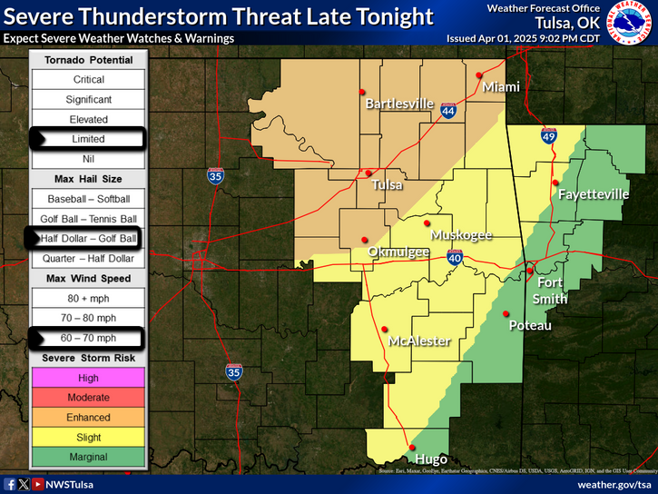
National Weather Service United States Department of Commerce

Beryl Forecast to Strengthen as it Heads Towards Southeast Texas; Dangerous Heat Continues in the Western and Eastern U.S.

There is an increasing risk of damaging hurricane-force winds, life-threatening storm surge, and flash flooding in southeast Texas late Sunday into Monday from Beryl. Extremely dangerous heat continues in the Western U.S. into next week, with heat persisting today from New York to the Gulf before gradually subsiding with time into next week. Excessive heat may bring heat-related illness. Read More >

Click a location below for detailed forecast.

Last Map Update: Sat, Jul 6, 2024 at 2:16:41 pm CDT

Scattered storms are expected to develop Sunday afternoon across northwest/north-central OK and eventually become a southeastward moving complex into Sunday evening. A mainly damaging wind threat with the storm complex could spread into parts of eastern OK, with the greatest potential to the west of highway 75.
TS Beryl is expected to make landfall on the TX coast as a hurricane on Monday, and then the remnant low of Beryl is expected to recurve to the northeast over the ArkLaTex Tuesday night into Wednesday. The forecast track of the storm is expected to keep the bulk of the impacts from this system to our south and east.
Hurricane Beryl is expected to track across the southern and western Gulf of Mexico. It will likely create some high seas along the Texas and Louisiana coastlines, increasing the risk for rip currents over the weekend and into next week. Please be aware of rip currents if you have plans to head to the coast.
Latest Text Product Selector (Selected product opens in a new window)

Decision Support Hazards Models Observations Climate Hydrology
 
 
Social Media Satellite Fire Weather Weather Radio Spotter Training Text Products