Last Map Update: Tue, Apr 14, 2026 at 3:50:36 am CDT


| Latest Text Product Selector (Selected product opens in a new window) | |
 |
 |
 |
 |
 |
 |
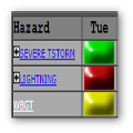
| Decision Support | Winter | Hazards | Observations | Climate | Hydrology |
 |
 |
 |
 |
 |
 |
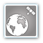
| Social Media | Satellite | Fire Weather | Weather Radio | Spotter Training | Text Products |
 |
|||||
| Models | |||||


 Tulsa Radar
  Weather Map
 Fort Smith Radar