A heat wave over the Southwest will intensify this week, peaking and expanding into the Intermountain West and northern High Plains this weekend. Severe thunderstorms and heavy rainfall are expected over parts of the Upper Midwest to mid-Mississippi Valley today. Critical to extremely critical fire weather conditions from the Northwest and the northern Great Basin on Saturday and Sunday. Read More >
Overview
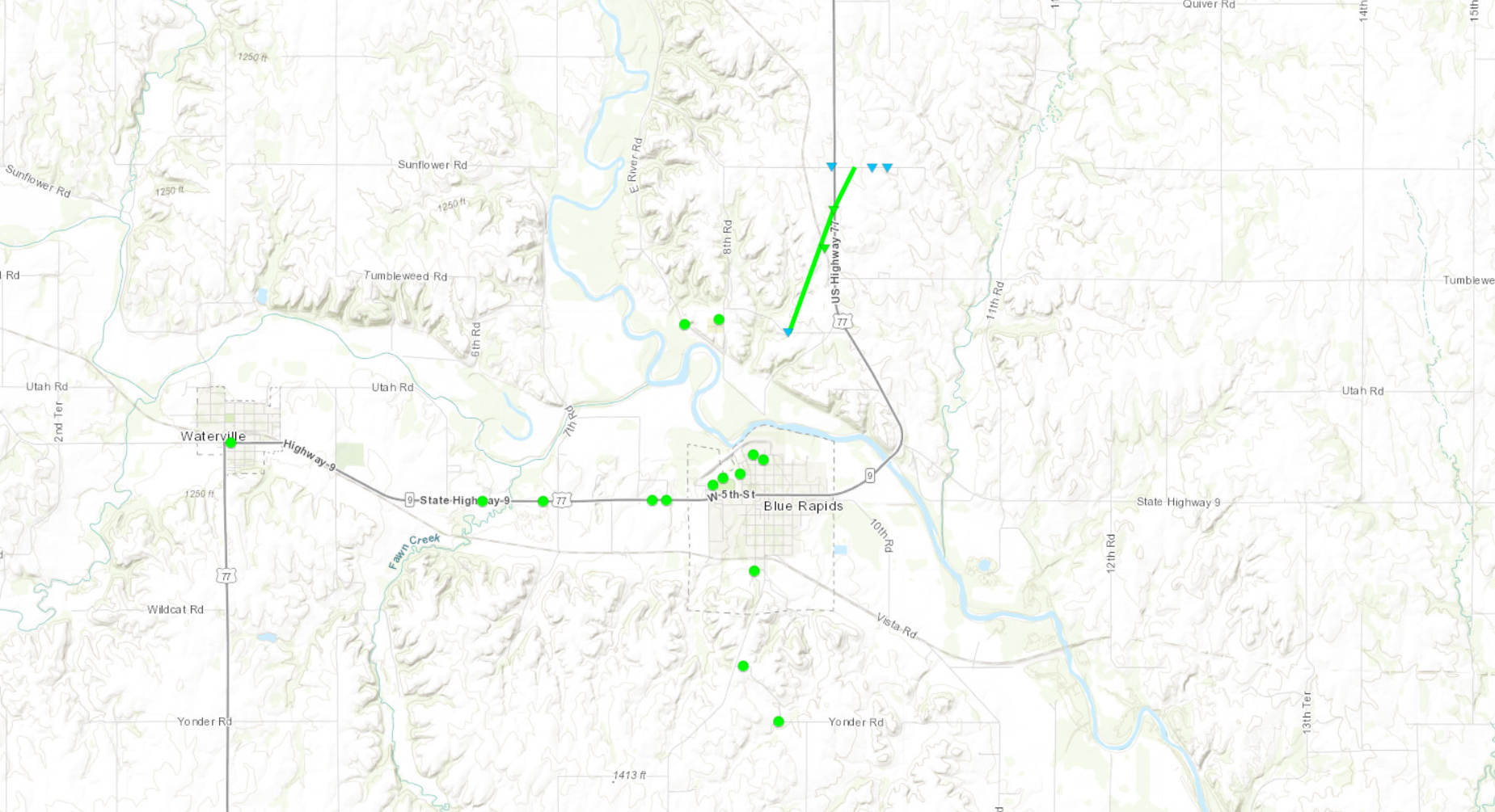
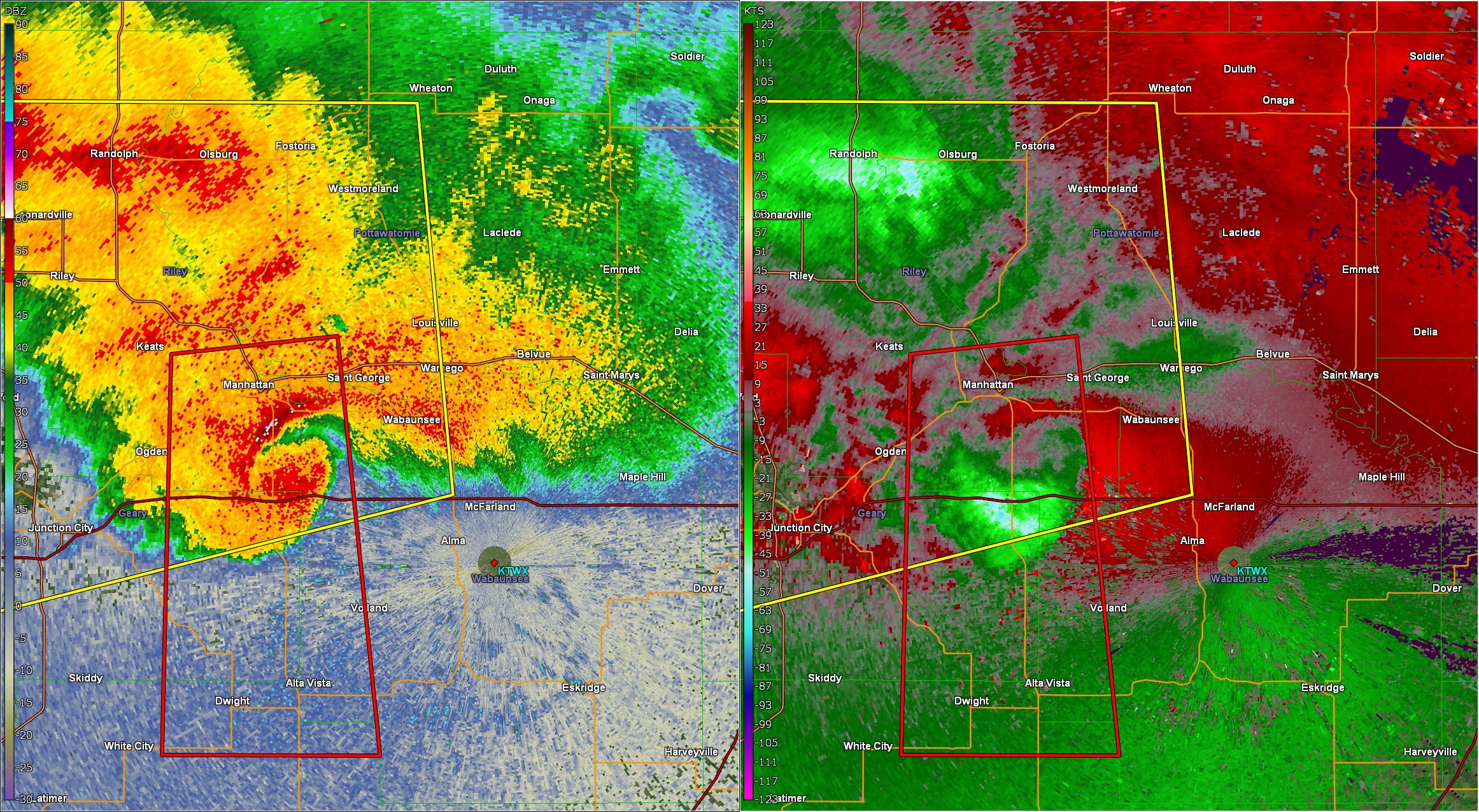
A large, high-precipitation supercell moved south across northeast Kansas over a five hour period. The supercell produced four EF-1 tornadoes, as well as several areas of straight-line winds in excess of 80 mph from the rear flank downdraft of the supercell:Tornadoes:
|
Tornado 1 - Nebraska/Kansas Border
|
||||||||||||||||
|
Tornado 2 - Marysville
|
||||||||||||||||
|
Tornado 3 - 1 Mile E of Marysville
|
||||||||||||||||
|
Tornado 4 - 1 Mile N of Blue Rapids
|
||||||||||||||||
|
Tornado 5 - 3 Miles E of Olsburg
|
||||||||||||||||
|
Tornado 6 - Manhattan
|
||||||||||||||||
|
Tornado 7 - 7 miles SE of Manhattan
|
||||||||||||||||
The Enhanced Fujita (EF) Scale classifies tornadoes into the following categories:
| EF0 Weak 65-85 mph |
EF1 Moderate 86-110 mph |
EF2 Significant 111-135 mph |
EF3 Severe 136-165 mph |
EF4 Extreme 166-200 mph |
EF5 Catastrophic 200+ mph |
 |
|||||
Photos & Video
Header
 |
 |
 |
 |
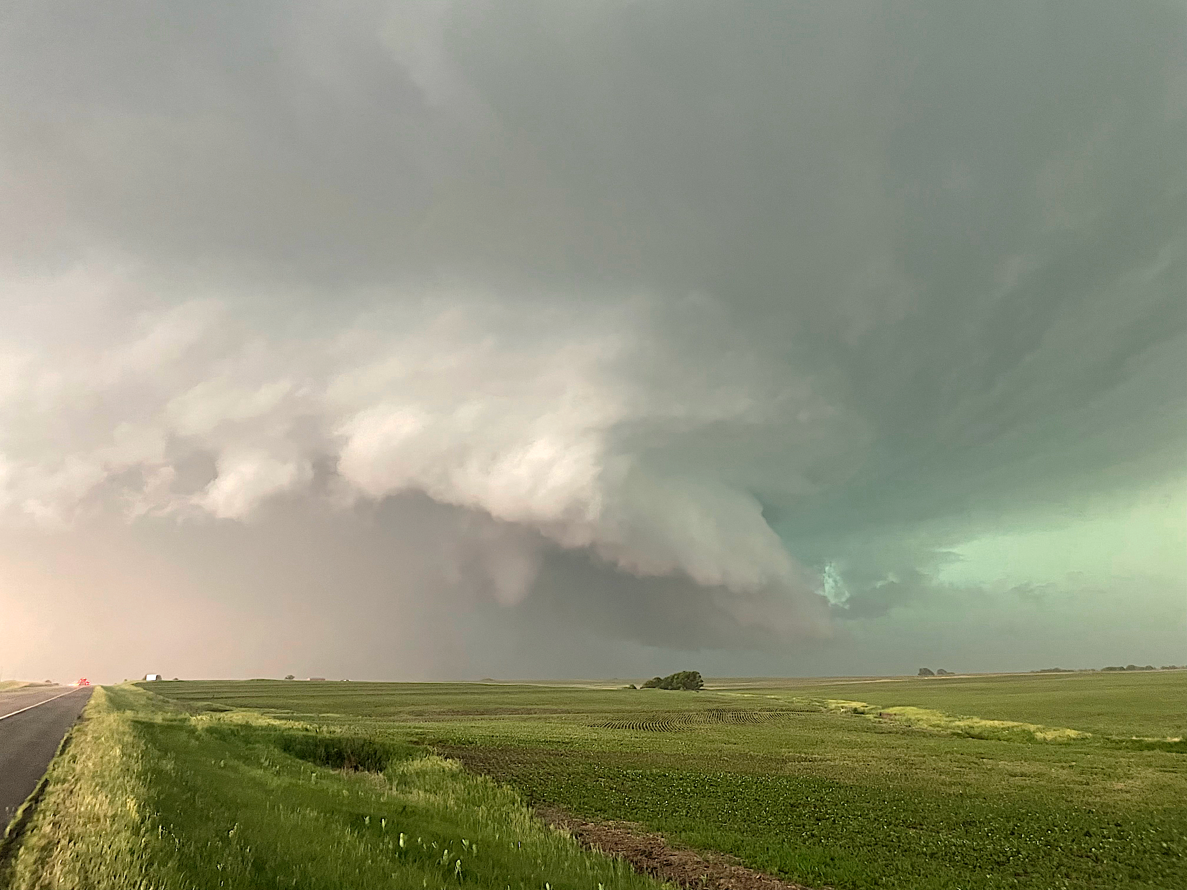
| Supercell as it approached Marysville. (Charles Peek) |
Brief tornado on the east side of Marysville, shortly after 6pm. | Supercell as it approached Blue Rapids. (Bryan Baerg) |
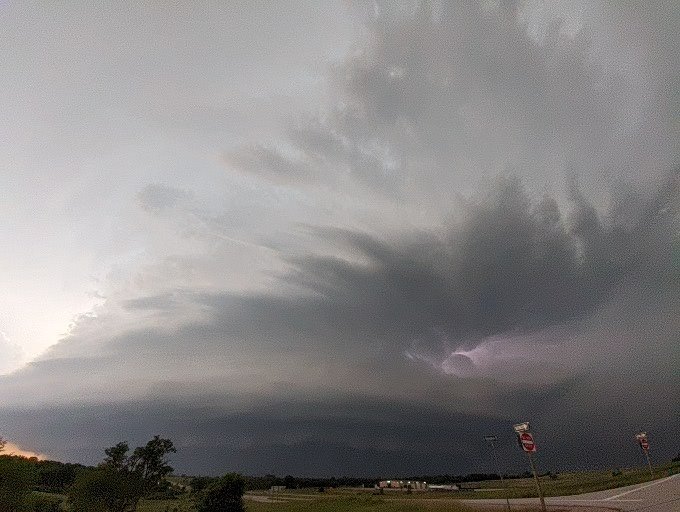
Supercell as it approached Manhattan. (Austin Jones) |
 |
 |
 |
 |
| EF-1 damage to an outbuilding along the KS/NE border. (NWS Damage Survey) |
EF-1 damage in Marysville. (NWS Damage Survey) |
Warehouse wall that collapsed onto a police car in Marysville. (Charles Peek) |
Damage to another warehouse in Marysville. (Freddy McKinney) |
|
 |
 |
 |
| EF-1 damage on the southeast side of Tuttle Creek Lake. (NWS Damage Survey) |
Overhead view of the damage in Manhattan. (Dawson Wagner) |
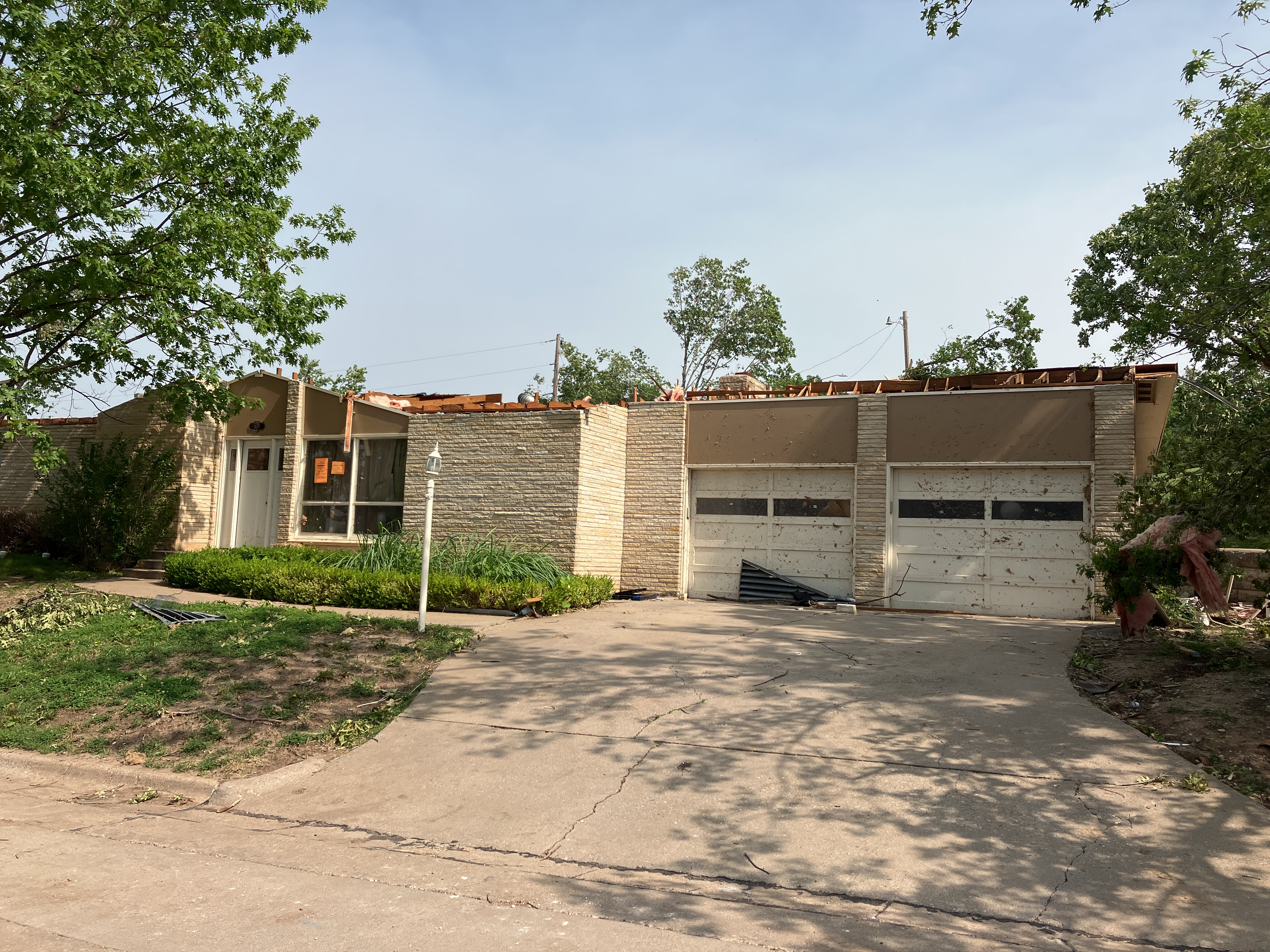
EF-2 damage in Manhattan. (NWS Damage Survey) |
EF-2 damage in Manhattan. (NWS Damage Survey) |
Radar
Header
 |
 |
 |
| Radar at 5:45 PM as the tornado neared the Kansas/Nebraska border. | Radar at 6:05 PM with likely two tornadoes occurring near Marysville. | Radar at 6:26 with the tornado just north of Blue Rapids. |
 |
 |
 |
| Radar at 7:11 with the tornado southeast of Olsburg. | Radar at 7:21 around the time of the brief EF-2 tornado in Manhattan. | Radar at 7:34 near the time of the brief tornado in open country southeast of Manhattan. |
Environment
Soundings |
 |
| 20z (3pm CDT) Topeka sounding | 0z (7pm CDT) Topeka sounding |
Storm Prediction Center Outlooks
 |
 |
 |
 |
| 11:30 AM SPC Outlook - Overall Categories | SPC Outlook - Tornado | SPC Outlook - Wind | SPC Outlook - Hail |
Additional environmental data.
 |
 |
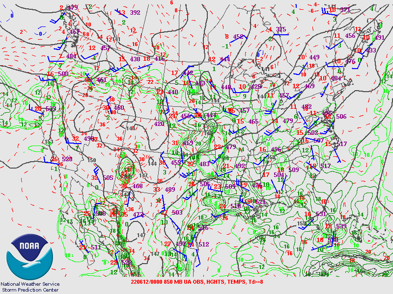 |
| 250 mb pattern valid at 7 pm | 500 mb pattern valid at 7 pm | 850 mb pattern valid at 7 pm |
 |
 |
 |
| Surface winds and mean sea level pressure valid at 7 pm | Surface-based CAPE valid at 7 pm | Effective shear valid at 7 pm |
 |
Media use of NWS Web News Stories is encouraged! Please acknowledge the NWS as the source of any news information accessed from this site. |
|