
Severe thunderstorms are forecast through this weekend along a slow moving cold front and secondary storm system that will impact areas from the southern Plains to the Great Lakes. Large hail and isolated damaging wind gusts are the main threats with these storms along with a risk for heavy to excessive rainfall which could bring flooding. Read More >
Significant Damage from an EF-2 Tornado in Harveyville, Kansas

On the evening of Tuesday, February 28 2012, a very strong upper level storm system caused widespread thunderstorms to form across most of central and eastern Kansas. The storms initiated approximately 4:00 PM and increased in coverage and intensity throughout the night. Since atmospheric instability was not extremely high there were few reports of severe hail; however, many structures across the area were damaged due to strong, straight-line thunderstorm winds.
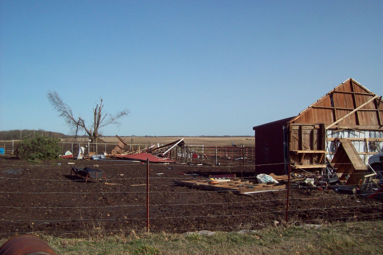
The most significant event from the evening of February 28 was a strong torando that impacted Harveyville, Kansas at approximately 9:03 pm CST. The town sustained significant damage to some structures, including an apartment complex and a church. On Wednesday, February 29 a National Weather Service survey crew travelled to Harveyville to assess the damage. The survey crew gave a preliminary assessment of EF-2 damage, indicating wind speeds of 111 - 135 mph.


Above: Radar reflectivity (left) and Storm Relative Velocity (right) indicates an area of enhanced rotation just west of Harveyville, Kansas. Click on the images to enlarge.
|
Harveyville Tornado, February 28, 2011 |
|
EF-0 |
EF-1 |
EF-2 |
EF-3 |
EF-4 |
EF-5 |
|
Tornado tracks and damage contours are based on individual damage points and should not be expected to be fully accurate down to the sub-neighborhood level. |
|
|
 |
 |
 |
 |
 |
 |
 |
 |
Public Information Statement
A weak tornado touches down in extreme Northern Franklin and South Central Douglas Counties.
|
Franklin-Douglas County Tornado on February 28, 2012 |
|
EF-0 |
EF-1 |
EF-2 |
EF-3 |
EF-4 |
EF-5 |
|
Tornado tracks and damage contours are based on individual damage points and should not be expected to be fully accurate down to the sub-neighborhood level. |
|
The path of the EF-0 tornado started 3 miles South of Globe in Northern Franklin County, then continued to 1.5 miles South of Worden, KS in Southern Douglas County. The estimated path length of the tornado was 3.5 miles, and the width of the tornado ranged from 50 yards to 100 yards. The time estimated from 10:06 PM CST to 10:11 PM CST. Several Barns were damaged or destroyed, and numerous trees were uprooted.
|
Photos of Damage from Franklin-Douglas County, Kansas on February 28, 2012 courtesy of the Douglas County Emergency Management office
 |
 |
 |
 |
 |
 |
A weak tornado touches down in extreme Northwest Cloud County.
PRELIMINARY LOCAL STORM REPORT
NATIONAL WEATHER SERVICE TOPEKA KS
428 PM CST WED FEB 29 2012
..TIME... ...EVENT... ...CITY LOCATION... ...LAT.LON...
..DATE... ....MAG.... ..COUNTY LOCATION..ST.. ...SOURCE....
..REMARKS..
0538 PM TORNADO 4 NW JAMESTOWN 39.64N 97.91W
02/28/2012 CLOUD KS NWS STORM SURVEY
EF0 TORNADO CONFIRMED IN FAR NORTHWEST CLOUD COUNTY VIA
DAMAGE REPORTS FROM SURVEY TEAM AND MULTIPLE PUBLIC
REPORTS. TORNADO LIKELY ENTERED FROM THE JEWELL-CLOUD
COUNTY LINE...4 WNW JAMESTOWN...AND ENDED 4 NW JAMESTOWN.
TOTAL PATH LENGTH WAS 2.5 MILES. EVENT OCCURRED FROM 536
PM CST TO 538 PM CST. NUMEROUS TREES UPROOTED OR SHEARED
OFF...10X40 METAL BUILDING DESTROYED...CARS DAMAGED BY
DEBRIS...PARTIAL BARN ROOF DAMAGED...WATER TANKS THROWN.
A map of all severe weather reports across the area.
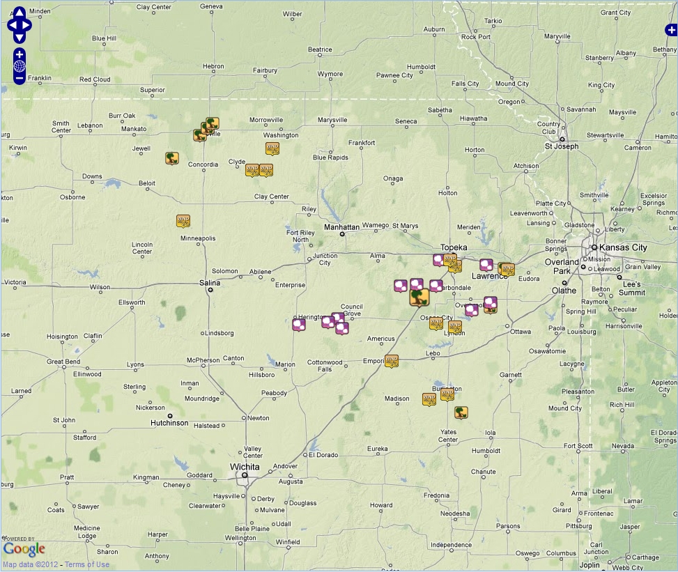
Click on image for an interactive damage map from February 28, 2012.
Some helpful links:


