Weather Impacts of ENSO
The Jetstream
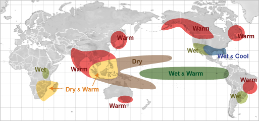
El Niño effect during June through August
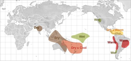
La Niña effect during December through February
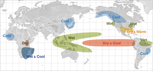
La Niña effect during June through August
 As the position of the warm water along the equator shifts back and
forth across the Pacific Ocean, the position where the greatest evaporation of
water into the atmosphere also shifts with it. This has a profound effect on the
average position of the jet stream which, in turn, effects the storm track.
As the position of the warm water along the equator shifts back and
forth across the Pacific Ocean, the position where the greatest evaporation of
water into the atmosphere also shifts with it. This has a profound effect on the
average position of the jet stream which, in turn, effects the storm track.
During El Niño (warm phase of ENSO), the jet stream's position shows a dip in the Eastern Pacific. The stronger the El Niño, the farther east in the Eastern Pacific the dip in the jetstream occurs. Conversely, during La Niña's, this dip in the jet stream shifts west of its normal position toward the Central Pacific.
The position of this dip in the jet stream, called a trough, can have a huge effect on the type of weather experienced in North America.
During the warm episode of ENSO (El Niño) the eastern shift in the trough typically sends the storm track, with huge amounts of tropical moisture, into California, south of its normal position of the Pacific Northwest.
Very strong El Niños will cause the trough to shift further south with the average storm track position moving into Southern California.
During these times, rainfall in California can be significantly above normal, leading to numerous occurrences of flash flood and debris flows. With the storm track shifted south, the Pacific Northwest becomes drier and drier as the tropical moisture is shunted south of the region.
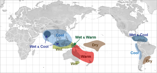
The maps (right) show the regions where the greatest impacts due to the shift in the jet stream as a result of ENSO. The highlighted areas indicate significant changes from normal weather occur. The the magnitude of the change from normal is dependent upon the strength of the El Niño or La Niña.