Springfield, MO
Weather Forecast Office
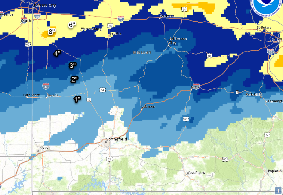
A couple of systems moved through the area from Sunday, December 15th through Monday, December 16th. As it happens frequently, the Missouri Ozarks was within the transition zone of precipitation types with these systems. Areas of far southern Missouri mostly had rainfall and some freezing rain, while further north up in central Missouri had more of a mix of sleet and snow. The heaviest snow with these systems affected areas north of Interstate 70 in the Kansas City and St. Louis areas. As the colder air moved in towards the end of the event on Monday, areas generally north of U.S. 60 had some light measurable snowfall. In our area, the region from Fort Leonard Wood to Rolla had the highest snow totals from 2 to 4 inches. Highest ice totals were in parts of south-central Missouri which had up to 0.20" of ice. Here is a map of the snow totals reported.
Current Hazards
Experimental Graphical Hazardous Weather Outlook
Submit a storm report
Local Storm Reports
Current Conditions
Observations
Lake Levels
Snowfall Analysis
Road Conditions
Satellite
CoCoRaHS
Graphical Conditions
Precip. Analysis
Forecasts
Forecast Discussion
Fire Weather
Aviation
GIS Forecast Maps
Activity Planner
Severe Weather
Winter Weather
Hurricanes
FAA Center Weather
Space Weather
Climatology
Records and Normals
Monthly Climate Summary
Local
National
Drought
Climate Science
Astronomical Data
US Dept of Commerce
National Oceanic and Atmospheric Administration
National Weather Service
Springfield, MO
Springfield-Branson National Airport
5805 West Highway EE
Springfield, MO 65802-8430
Business: 417-863-8028 Recording: 417-869-4491
Comments? Questions? Please Contact Us.


 Weather Story
 Weather Map
 Local Radar